
ckanext-geoview - Geospatial viewer for CKAN resources
This extension contains view plugins to display geospatial files and services in CKAN. It contains an OpenLayers based viewer originally developed by Philippe Duchesne and other view plugins that used to be part of ckanext-spatial.
Note: This is a work in progress, if you can help with OpenLayers or Leaflet development, check the Issues section for what needs to be done or add a new issue.
This extension supports CKAN 2.10 onwards.
Installation
To install ckanext-geoview on a production site:
-
Activate your CKAN virtual environment, for example:
source /usr/lib/ckan/default/bin/activate -
Install the ckanext-geoview Python package into your virtual environment:
pip install ckanext-geoview -
Add the relevant plugins to the
ckan.pluginssetting in your CKAN config file (by default the config file is located at/etc/ckan/default/production.ini). Check Available plugins to see which ones are available and if they require further configuration. -
Add the
resource_proxyplugin to theckan.pluginssetting. -
Restart CKAN.
Development Installation
To install ckanext-geoview for development:
-
Clone the source:
cd /usr/lib/ckan/default/src git clone https://github.com/ckan/ckanext-geoview.git -
Activate your CKAN virtual environment, for example:
source /usr/lib/ckan/default/bin/activate -
Install the ckanext-geoview Python package into your python virtual environment:
cd ckanext-geoview pip install -e . -
Continue with the main installation instructions above (step 3 onwards).
Available plugins
OpenLayers Viewer
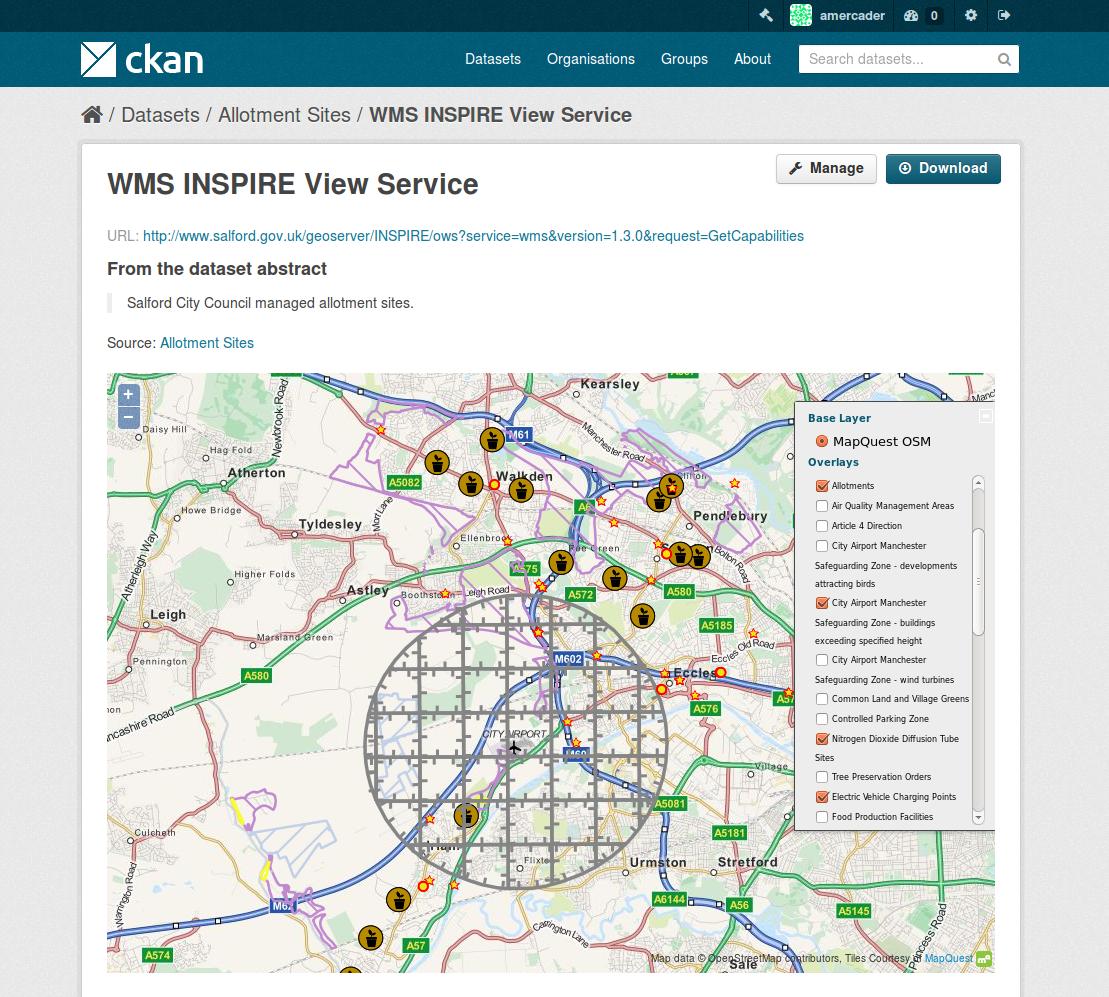
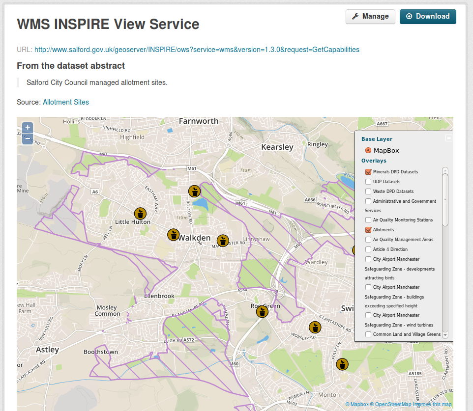
The OpenLayers viewer provides access to different geospatial formats and services:
To enable it, add geo_view to your ckan.plugins setting:
ckan.plugins = ... resource_proxy geo_view
If you want the geospatial views to be created by default, add the plugin to the following setting:
ckan.views.default_views = ... geo_view
The formats and services supported are:
| Type | Resource format (*) |
|---|---|
| Web Map Service (WMS) | wms |
| Web Feature Service (WFS) | wfs |
| GeoJSON | geojson |
| GML | gml |
| KML | kml |
| ArcGIS REST API | arcgis_rest |
| Google Fusion Tables | gft |
(*) Resource formats are case insensitive
Support varies across formats, so you might want to deactivate the ones you are not interested in. To choose which formats to display, set the following configuration option:
ckanext.geoview.ol_viewer.formats = wms kml
To render Google Fusion Tables resources, a Google API Key must be provided in the ini file:
ckanext.geoview.gapi_key = <API Key here>
This key must be granted Fusion Tables permissions. More information on obtaining such a key can be found at https://developers.google.com/fusiontables/docs/v1/using#APIKey.
All configuration options relating to the OpenLayers viewer (ie those prefixed with ckanext.geoview.ol_viewer.*)
are passed to the JavaScript module, where they are accessible on the options.ol_config object:
this.ckan.module('olpreview', function (jQuery, _) {

    // ...

    _onReady: function () {


        console.log(this.options.ol_config)

    }

    // ...

}
Other available configuration options are:
ckanext.geoview.ol_viewer.hide_overlays: if set to True, overlays won't be visible by default (only the base layer)ckanext.geoview.ol_viewer.default_feature_hoveron: if set to True, feature data popup will be displayed when hovering onckanext.geoview.ol_viewer.forward_ogc_request_params: if set to True, OGC request parameters that may be present in resource URLs will be kept as part of proxied service requests. If False (default), such parameters will be removed from URL when proxying requests.
Each instance of a view has the following configuration options that can override the global configuration:
feature_hoveron: if set to True, feature data popup will be displayed when hovering onfeature_style: JSON representation of an OpenLayers style, as accepted by the StyleMap constructor
Specific basemap support
In addition to the basemap types described in Common base layers for Map Widgets, the OpenLayers viewer supports several other basemap types, namely TMS, WMTS, WMS
TMS example (here in Mercator projection):
ckanext.spatial.common_map.tms.url = <tms URL>
ckanext.spatial.common_map.tms.srs = EPSG:900913
ckanext.spatial.common_map.tms.layername = <TMS layer name>
ckanext.spatial.common_map.tms.resolutions = [156543.03390625,78271.516953125,39135.7584765625,19567.87923828125,9783.939619140625,4891.9698095703125,2445.9849047851562,1222.9924523925781,611.4962261962891,305.74811309814453,152.87405654907226,76.43702827453613,38.218514137268066,19.109257068634033,9.554628534317017,4.777314267158508,2.388657133579254,1.194328566789627,0.5971642833948135,0.29858214169740677,0.14929107084870338,0.07464553542435169,0.037322767712175846,0.018661383856087923,0.009330691928043961,0.004665345964021981,0.0023326729820109904,0.0011663364910054952,5.831682455027476E-4,2.915841227513738E-4,1.457920613756869E-4]
ckanext.spatial.common_map.tms.extent = [-20037508.34, -20037508.34,20037508.34, 20037508.34]
WMTS (in this case parameters will be fetched from online capabilities):
ckanext.spatial.common_map.type = wmts
ckanext.spatial.common_map.wmts.url = <wmts URL>
ckanext.spatial.common_map.wmts.layer = <WMTS layer name>
ckanext.spatial.common_map.wmts.srs = EPSG:4326
WMS:
ckanext.spatial.common_map.wms.url = <wms URL>
ckanext.spatial.common_map.wms.layer = <layer name>
ckanext.spatial.common_map.wms.srs = EPSG:31370
ckanext.spatial.common_map.wms.extent = [141192.712000, 161464.403000, 158005.472000, 178169.335000]
Multi basemaps
Multiple basemaps can be defined in a separate file, and will result in a dropdown in the interface allowing to switch between basemaps. Basemap definition file is defined as follows:
#ckanext.geoview.basemaps=%(here)s/basemaps.json
(here pointing to a file next to the ini file). This file is a JSON encoded array of basemap definitions reproducing the structure and syntax described above:
[
    {
        "title": "OSM",
        "type" : "custom",
        "url" : "https://tile.openstreetmap.org/{z}/{x}/{y}.png",
        "attribution" : " Map tiles & Data by OpenStreetMap, under CC BY SA."
    },
    {
        "title": "Blue Marble Mercator",
        "type" : "tms",
        "url" : "http://demo.opengeo.org/geoserver/gwc/service/tms/",
        "srs" : "EPSG:900913",
        "layername" : "nasa%3Abluemarble@EPSG%3A900913@png",
        "resolutions" : [156543.03390625,78271.516953125,39135.7584765625,19567.87923828125,9783.939619140625,4891.9698095703125,2445.9849047851562,1222.9924523925781,611.4962261962891,305.74811309814453,152.87405654907226,76.43702827453613,38.218514137268066,19.109257068634033,9.554628534317017,4.777314267158508,2.388657133579254,1.194328566789627,0.5971642833948135,0.29858214169740677,0.14929107084870338,0.07464553542435169,0.037322767712175846,0.018661383856087923,0.009330691928043961,0.004665345964021981,0.0023326729820109904,0.0011663364910054952,5.831682455027476E-4,2.915841227513738E-4,1.457920613756869E-4],
        "extent" : [-20037508.34, -20037508.34,20037508.34, 20037508.34]
    },
    {
        "title": "Blue Marble 4326",
        "type" : "tms",
        "url" : "http://demo.opengeo.org/geoserver/gwc/service/tms/",
        "srs" : "EPSG:4326",
        "layername" : "nasa%3Abluemarble@EPSG%3A4326@png",
        "resolutions" : [0.703125,0.3515625,0.17578125,0.087890625,0.0439453125,0.02197265625,0.010986328125,0.0054931640625,0.00274658203125,0.001373291015625,6.866455078125E-4,3.4332275390625E-4,1.71661376953125E-4,8.58306884765625E-5,4.291534423828125E-5,2.1457672119140625E-5,1.0728836059570312E-5,5.364418029785156E-6,2.682209014892578E-6,1.341104507446289E-6,6.705522537231445E-7,3.3527612686157227E-7],
        "extent" : [-180,-90,180,90]
    },
    {
        "title": "Opengeo WMS demo",
        "type" : "wms",
        "url" : "http://demo.opengeo.org/geoserver/ows",
        "layer" : "ne:NE1_HR_LC_SR_W_DR",
        "srs" : "EPSG:4326",
        "extent" : [-180,-90,180,90]
    }
]
When declared, this basemap list will override the ckanext.spatial.common_map properties.
URL specification
For WMS and WFS views, the URL must be specified carefully to get the desired result. In general, to browse the offered layers or features of a WMS or WFS endpoint, just specify the endpoint in the URL field of the resource, e.g.:
https://neo.sci.gsfc.nasa.gov/wms/wms
or
http://giswebservices.massgis.state.ma.us/geoserver/wfs
You can request individual layers/features using the "#" sign, e.g.:
https://neo.sci.gsfc.nasa.gov/wms/wms#MOD14A1_M_FIRE
or
http://giswebservices.massgis.state.ma.us/geoserver/wfs#GISDATA.MINLL1_ARC
N.B. For WFS this is the feature name without the qualifier, e.g. GISDATA.MINLL1_ARC and not massgis:GISDATA.MINLL1_ARC in the example above.
Leaflet GeoJSON Viewer
Note: This plugin used to be part of ckanext-spatial.
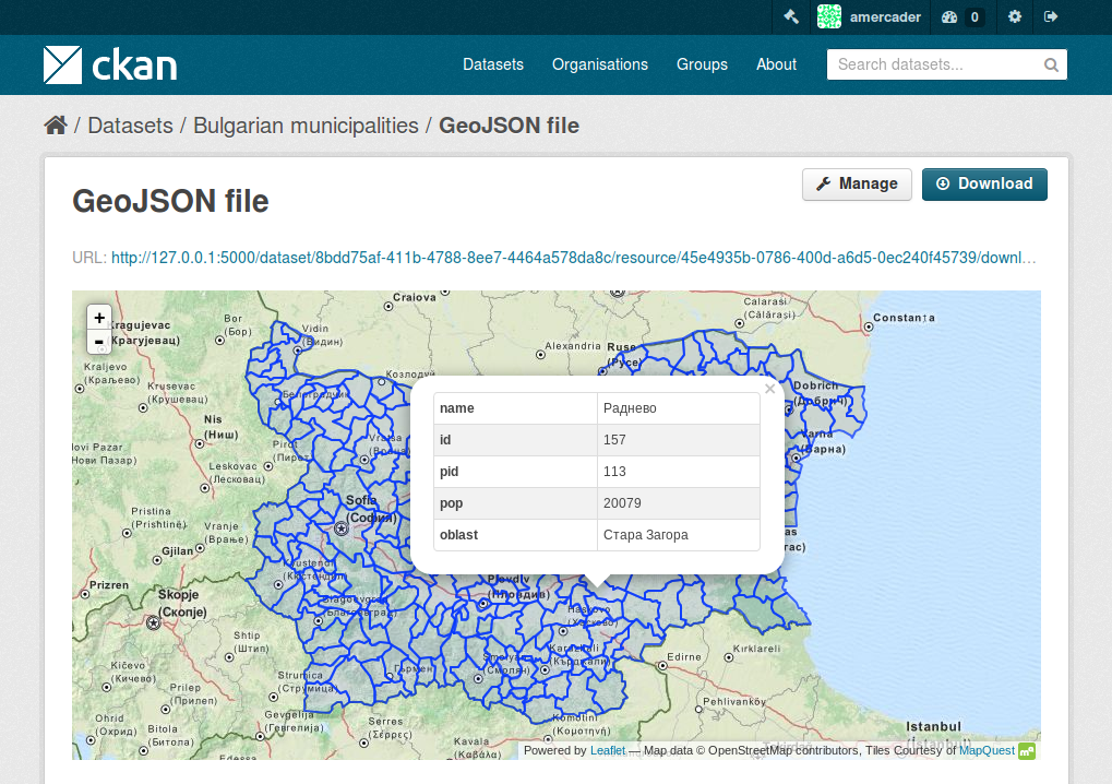
The Leaflet GeoJSON viewer will render GeoJSON files on a map and add a popup showing the features properties, for those resources that have a geojson format.
To enable it, add geojson_view to your ckan.plugins setting:
ckan.plugins = ... resource_proxy geojson_view
If you want the views to be created by default on all GeoJSON files, add the plugin to the following setting:
ckan.views.default_views = ... geojson_view
You can use the ckanext.geoview.geojson.max_file_size configuration option to define the maximum file size (in bytes) that will be rendered in the map widget. Default is 25 Mb.
Note that this relies on the resource size field being set (ie it will only work with uploaded files, not linked externally).
Base map (MapBox) example configuration
ckanext.spatial.common_map.type = MapBox
ckanext.spatial.common_map.mapbox.id = mapbox/streets-v12
ckanext.spatial.common_map.mapbox.accesstoken = <your_mapbox_public_token>
For envvars:
CKANEXT__SPATIAL__COMMON_MAP__TYPE=MapBox
CKANEXT__SPATIAL__COMMON_MAP__MAPBOX__ID=mapbox/streets-v12
CKANEXT__SPATIAL__COMMON_MAP__MAPBOX__ACCESSTOKEN=<your_mapbox_public_token>
Leaflet WMTS Viewer
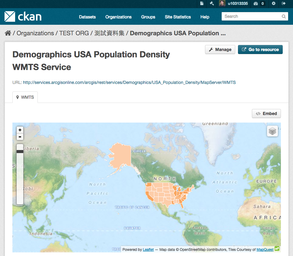
The Leaflet WMTS viewer will render WMTS (Web Map Tile Service) layers on a map for those resources that have a wmts format.
To enable it, add wmts_view to your ckan.plugins setting:
ckan.plugins = ... resource_proxy wmts_view
If you want the views to be created by default on all WMTS resources, add the plugin to the following setting:
ckan.views.default_views = ... wmts_view
Leaflet ESRI Shapefile Viewer
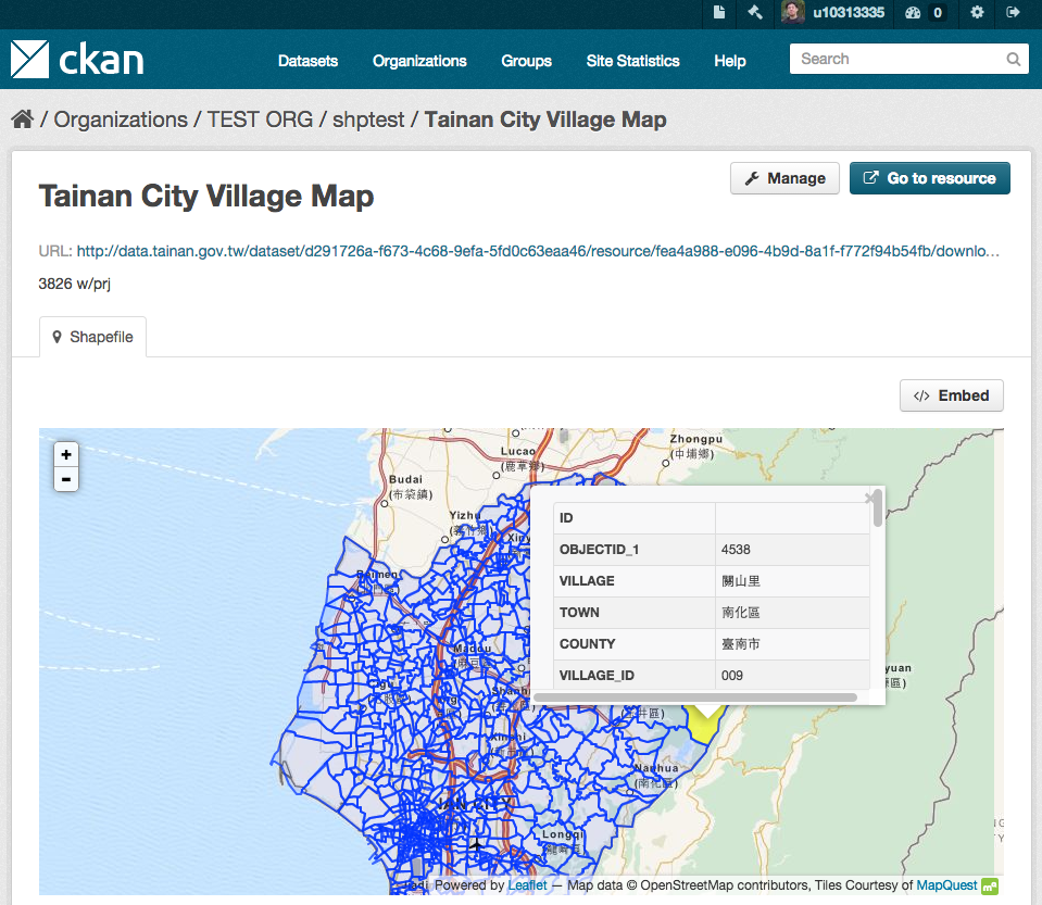
The Leaflet Shapefile viewer will render ESRI Shapefiles (A ZIP archive contains the .shp, .shx, .dbf, and .prj files) on a map and add a popup showing the features properties, for those resources that have a shp format.
To enable it, add shp_view to your ckan.plugins setting:
ckan.plugins = ... resource_proxy shp_view
If you want the views to be created by default on all Shapefiles, add the plugin to the following setting:
ckan.views.default_views = ... shp_view
The projection information (EPSG code, e.g., 4326 and 3857) will be loaded if there is a .prj file provided. You can also add a new field named 'resource_crs' in your custom resource fields or the following configuration option (The loading order is: .prj file, 'resource_crs' field, option and EPSG:4326/WGS84):
ckanext.geoview.shp_viewer.srid = 4326
The encoding of the shapefile can be defined by a custom resource field named 'encoding' in the metadata of the dataset or the following configuration option (The loading order is: 'encoding' field, option and UTF-8):
ckanext.geoview.shp_viewer.encoding = UTF-8
Common base layers for Map Widgets
The geospatial view plugins support the same base map configurations as the ckanext-spatial widgets.
Check the following page to learn how to choose a different base map layer:
http://docs.ckan.org/projects/ckanext-spatial/en/latest/map-widgets.html
Updating the JS libraries
To update a JS library to a new version:
- Update the version number in
package.json - Run
npm install - Run
npm run update-libs
The following libraries are managed manually as they don't have npm packages:
- ol-helpers
- shp2geojson
Releasing a new version of ckanext-geoview
ckanext-geoview is available on PyPI as https://pypi.python.org/pypi/ckanext-geoview. To publish a new version to PyPI follow these steps:
-
Update the version number in the
pyproject.tomlfile. See PEP 440 for how to choose version numbers. -
Build the distribution:
pip install build python -m build -
Upload to PyPI:
pip install twine twine upload dist/* -
Tag the new release of the project on GitHub with the version number from the
pyproject.tomlfile. For example if the version number is 0.2.3 then do:git tag 0.2.3 git push --tags
Metadata
Release files for ckanext-geoview 0.3.2
For a detailed explanation of source distributions (sdists) and built distributions (wheels), please see the package formats documentation.
Source distribution (sdist)
| File | Size | Uploaded | |
|---|---|---|---|
| ckanext_geoview-0.3.2.tar.gz | 491.4 kB | Details |
Built distribution (wheel)
| File | Interpreter | ABI | Platform | Reset |
|---|---|---|---|---|
| ckanext_geoview-0.3.2-py3-none-any.whl | Python 3 | none | any | Details |
Total release size: 988.9 kB
Release files / ckanext_geoview-0.3.2.tar.gz
| Download URL | ckanext_geoview-0.3.2.tar.gz |
|---|---|
| Size | 491.4 kB |
| Tags | Source |
|
SHA-256 checksum How to use checksums |
749a5742eae2ce01815f1c2df55f468c22727472134ce4d96818aad522a7589a
|
|
BLAKE2b-256 checksum How to use checksums |
63ca83ab34bd2050da3d00703adb96206df12068b13d7902c779de33c70b5562
|
| Upload date | |
|
Uploaded using Trusted Publishing? What is trusted publishing? |
Yes |
| Uploaded via |
twine/6.1.0 CPython/3.13.13
|
Provenance
Provenance describes where a file came from. On PyPI, provenance is shared via attestations, which provide a verifiable record of the build or publishing details. View details, limitations and caveats.


PyPI Publish Attestation
PyPI verified that this artifact, at this checksum, originated from the publisher listed below.
Signed by GitHub Actions, verified by PyPI on Oct 2, 2026.
Transparency logRelease files / ckanext_geoview-0.3.2-py3-none-any.whl
| Download URL | ckanext_geoview-0.3.2-py3-none-any.whl |
|---|---|
| Size | 497.5 kB |
| Tags | Python 3 |
|
SHA-256 checksum How to use checksums |
ac806af6a381f8cfbd4a814fb3f772f8eb3715d0fa0e4e934d12d110432e7346
|
|
BLAKE2b-256 checksum How to use checksums |
743e233ed0dc7eb5383929aa2f48e6fb82cf5ec9bd19fd6a9c9c26429b29c117
|
| Upload date | |
|
Uploaded using Trusted Publishing? What is trusted publishing? |
Yes |
| Uploaded via |
twine/6.1.0 CPython/3.13.13
|
Provenance
Provenance describes where a file came from. On PyPI, provenance is shared via attestations, which provide a verifiable record of the build or publishing details. View details, limitations and caveats.
PyPI Publish Attestation
PyPI verified that this artifact, at this checksum, originated from the publisher listed below.
Signed by GitHub Actions, verified by PyPI on Oct 2, 2026.
Transparency log













