Generate an interactive geo-heatmap from your Google location data
Project description
Geo Heatmap
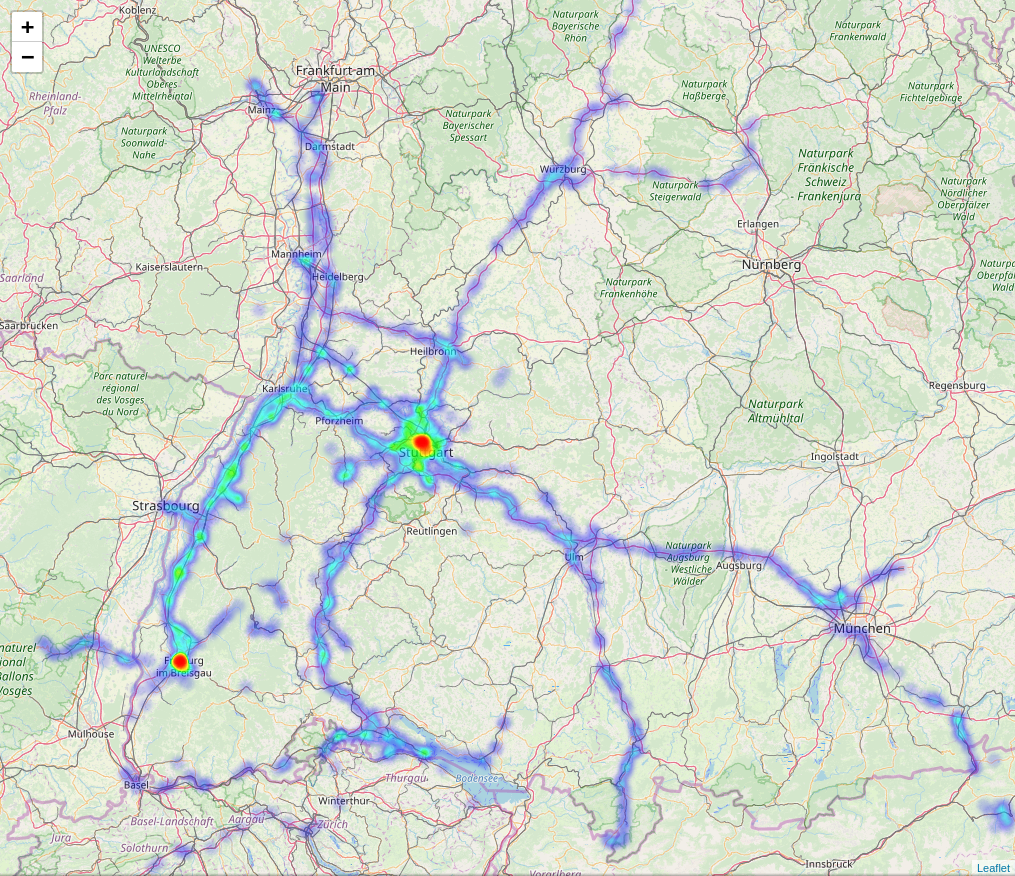
This is a script that generates an interactive geo heatmap from your Google location history data using Python, Folium and OpenStreetMap.
Getting Started
1. Install Python 3+
If you don't already have Python 3+ installed, grab it from https://www.python.org/downloads/. You'll want to download install the latest version of Python 3.x. As of 2019-11-22, that is Version 3.8.
For ease of python version handling, I'd recommend installing it through pyenv.
2. Get Your Location Data
Here you can find out how to download your Google data: https://support.google.com/accounts/answer/3024190?hl=en
Here you can download all of the data that Google has stored on you: https://takeout.google.com/
To use this script, you only need to select and download your "Location History", which Google will provide to you as a JSON file by default. KML is also an output option and is accepted for this program.
3. Install the script
In a command prompt or Terminal window, navigate to the directory containing the location data files. Then, type the following, and press enter:
pip install geo-heatmap
4. Run the Script
In the same command prompt or Terminal window, type the following, and press enter:
geo-heatmap <file> [<file> ...]
Replace the string <file> from above with the path to any of the following files:
- The
Location History.jsonJSON file from Google Takeout - The
Location History.kmlKML file from Google Takeout - The
takeout-*.zipraw download from Google Takeout that contains either of the above files
Examples:
Single file:
geo-heatmap C:\Users\Testuser\Desktop\locations.json
geo-heatmap "C:\Users\Testuser\Desktop\Location History.json"
geo-heatmap locations.json
Multiple files:
geo-heatmap locations.json locations.kml takeout.zip
Using the stream option (for users with Memory Errors):
geo-heatmap -s locations.json
Set a date range:
geo-heatmap --min-date 2017-01-02 --max-date 2018-12-30 locations.json
Usage:
usage: geo-heatmap [-h] [-o] [--min-date YYYY-MM-DD]
                      [--max-date YYYY-MM-DD] [-s] [--map MAP]
                      file [file ...]

positional arguments:
  file                  Any of the following files:
                        1. Your location history JSON file from Google Takeout
                        2. Your location history KML file from Google Takeout
                        3. The takeout-*.zip raw download from Google Takeout
                        that contains either of the above files

optional arguments:
  -h, --help            show this help message and exit
  -o , --output         Path of heatmap HTML output file.
  --min-date YYYY-MM-DD
                        The earliest date from which you want to see data in the heatmap.
  --max-date YYYY-MM-DD
                        The latest date from which you want to see data in the heatmap.
  -s, --stream          Option to iteratively load data.
  --map MAP, -m MAP     The name of the map tiles you want to use.
                        (e.g. 'OpenStreetMap', 'StamenTerrain', 'StamenToner', 'StamenWatercolor')
6. Review the Results
The script will generate a HTML file named heatmap.html. This file will automatically open in your browser once the script completes. Enjoy!
FAQ
I'm getting an "Out of Memory" error or MemoryError when I try to run the script. What's going on?
Your LocationHistory.json file is probably huge, and Python is running out of memory when the script tries to parse that file.
To fix this, download and install the 64-bit version of Python. To do this:
- Go to python.org.
- Click the link corresponding to your OS next to "Looking for Python with a different OS?"
- Click the "Latest Python 3 Release" link.
- Scroll down to "Files".
- Click to download the x64 release. For example, on Windows, that's the "Windows x86-64 executable installer" link.
- Install!
If this does not fix the issue you can use the stream option:
geo-heatmap -s <file>
This will be slower but will use much less memory to load your location data.
I'm getting a SyntaxError when running pip install -r requirements.txt or python geo_heatmap.py <file>. What am I doing wrong?
You are probably using the python interpreter to run these commands. Try to run them in cmd.exe or Windows PowerShell (Windows) or the Terminal (Linux, MacOS).
I'm getting the error message TypeError: __init__() got an unexpected keyword argument 'max_value'. What can I do to fix this?
Try to run:
pip uninstall progressbar
pip install progressbar2
You probably have progressbar installed, which uses maxval as an argument for __init__. Progressbar2 uses max_value.
Development
This project is using Poetry to manage dependencies. You can install it by following their guide.
If you would like to develop on this further, after cloning this repository and navigating into it you can get up and running with the following:
poetry install
poetry run geo-heatmap
Project details
Release history Release notifications | RSS feed
Download files
Download the file for your platform. If you're not sure which to choose, learn more about installing packages.
Source Distribution
Built Distribution
Hashes for geo_heatmap-0.1.5-py3-none-any.whl
| Algorithm | Hash digest | |
|---|---|---|
| SHA256 | 34f9912801c27734cdc301c3cab3e5134eb668944f0230961ee12b943be6192e |
|
| MD5 | 42ed950d1d9d67f3637406deb21bdeaf |
|
| BLAKE2b-256 | fcb82cb922a749f670a856f627650628d2d7a1d17358a9c925e9b4300fc40852 |


