Geoformat is a 99 % python geospatial blacksmith


Project description
Welcome to Geoformat
Introduction
Geoformat is a geospatial library. The library aims to simplify loading data, manipulations, and storage of geospatial data. Currently, this library is in Alpha mode. This means that at the moment, the structure of this library is not fully object-oriented compatible.
Installation
$ pip install geoformat
Geoformat Cookbook
- Create geoformat objects
- Geometry usefully functions
- Attributes usefully functions
- Feature usefully functions
- Geolayer usefully functions
- Write geolayer in GIS file
Create geoformat objects
When you use Geoformat, there are two basic objects:
- feature: the content. This object can store attributes and/or geometry data.
- geolayer: the container. It stores features. It is equivalent to a table in a database.
Create a feature
A feature contains attributes and geometry information. (For more technical information, see: Geoformat Technical Description [WIP])
# create a feature dict
feature = {}

# add attributes data
feature['attributes'] = {'integer_field': 1704, 'string_field': 'hello world', 'real_list_field': [123.43, 65., 356.65]}

# add geometry data
feature['geometry'] = {'type': 'Point', 'coordinates': [2.34886039, 48.85332408]}

print(feature)

# >>> {'attributes': {'integer_field': 1704, 'string_field': 'hello world', 'real_list_field': [123.43, 65.0, 356.65]}, 'geometry': {'type': 'Point', 'coordinates': [2.34886039, 48.85332408]}}
Create a geolayer
A geolayer is an equivalent to a file or a table in database containing one or several features with attibutes and/or geometry. (For more technical information, see: Geoformat Technical Description [WIP])
handmade
# first create geolayer dict with 'metadata' keys and features 'keys'
geolayer = {"metadata": {"name": "handmade geolayer"}, "features": {}}

# create fields metadata
metadata_fields = {
    "id": {"type": "Integer", "index": 0},
    "foo": {"type": "String", "width": 50, "index": 1}
}

# create geometry metadata
metadata_geometry = {"type": {"Point", "LineString"}, "crs": 4326}

# rattach fields metadata and geometry metadata to geolayer metadata
geolayer["metadata"]["fields"] = metadata_fields
geolayer["metadata"]["geometry_ref"] = metadata_geometry

# create features
feature_a = {"attributes": {"id": 8754, "foo": "bar"}, "geometry": {"type": "Point", "coordinates": [2.3488, 48.8533]}}
feature_b = {"attributes": {"id": 764, "foo": "baz"}, "geometry": {"type": "LineString", "coordinates": [[-2.1368, 47.2829], [-1.5655, 47.1971],  [3.9097, 44.8938]]}}

# rattach features to geolayer
geolayer['features'][0] = feature_a
geolayer['features'][1] = feature_b

print(geolayer)

# >>> {'metadata': {'name': 'handmade geolayer', 'fields': {'id': {'type': 'Integer', 'index': 0}, 'foo': {'type': 'String', 'width': 50, 'index': 1}}, 'geometry_ref': {'type': {'LineString', 'Point'}, 'crs': 4326}}, 'features': {0: {'attributes': {'id': 8754, 'foo': 'bar'}, 'geometry': {'type': 'Point', 'coordinates': [2.3488, 48.8533]}}, 1: {'attributes': {'id': 764, 'foo': 'baz'}, 'geometry': {'type': 'LineString', 'coordinates': [[-2.1368, 47.2829], [-1.5655, 47.1971], [3.9097, 44.8938]]}}}}
Using a driver
import geoformat

departement_path = 'data/FRANCE_IGN/DEPARTEMENT_2016_L93.shp'

geolayer = geoformat.shapefile_to_geolayer(departement_path)

print(len(geolayer['features']))

# >>> 96
Print data geolayer
Sometimes it can be useful to print in terminal geolayer's attributes.
Print fields metadata
import geoformat

region_path = 'data/FRANCE_IGN/REGION_2016_L93.shp'

geolayer = geoformat.shapefile_to_geolayer(region_path)

print(geoformat.print_metadata_field_table(geolayer))

# >>>
# +------------+---------+-------+-----------+-------+
# | field name | type    | width | precision | index |
# +============+=========+=======+===========+=======+
# | CODE_REG   | String  | 2     | None      | 0     |
# | NOM_REG    | String  | 35    | None      | 1     |
# | POPULATION | Integer | None  | None      | 2     |
# | SUPERFICIE | Integer | None  | None      | 3     |
# +------------+---------+-------+-----------+-------+
Print features data
import geoformat

region_path = 'data/FRANCE_IGN/REGION_2016_L93.shp'

geolayer = geoformat.shapefile_to_geolayer(region_path)

print(geoformat.print_features_data_table(geolayer))

# ### >>>
# +--------+----------+-------------------------------------+------------+------------+--------------+--------------------------------+
# | i_feat | CODE_REG | NOM_REG                             | POPULATION | SUPERFICIE | type         | coordinates                    |
# +========+==========+=====================================+============+============+==============+================================+
# | 0      | 76       | LANGUEDOC-ROUSSILLON-MIDI-PYRENEES  | 5683878    | 7243041    | MultiPolygon | [[[[449862.6000001011, ...]]]] |
# | 1      | 75       | AQUITAINE-LIMOUSIN-POITOU-CHARENTES | 5844177    | 8466821    | MultiPolygon | [[[[547193.100000056,  ...]]]] |
# | 2      | 84       | AUVERGNE-RHONE-ALPES                | 7757595    | 7014795    | Polygon      | [[[831613.6999999505, 6 ...]]] |
# | 3      | 32       | NORD-PAS-DE-CALAIS-PICARDIE         | 5987883    | 3187435    | Polygon      | [[[608820.0000000052, 7 ...]]] |
# | 4      | 44       | ALSACE-CHAMPAGNE-ARDENNE-LORRAINE   | 5552388    | 5732928    | Polygon      | [[[776081.0999999898, 6 ...]]] |
# | 5      | 93       | PROVENCE-ALPES-COTE D'AZUR          | 4953675    | 3155736    | MultiPolygon | [[[[1009696.399999884, ...]]]] |
# | 6      | 27       | BOURGOGNE-FRANCHE-COMTE             | 2819783    | 4746283    | Polygon      | [[[826122.1999999635, 6 ...]]] |
# | 7      | 52       | PAYS DE LA LOIRE                    | 3660852    | 2997777    | MultiPolygon | [[[[396406.200000058,  ...]]]] |
# | 8      | 28       | NORMANDIE                           | 3328364    | 2728511    | MultiPolygon | [[[[414934.20000005106 ...]]]] |
# | 9      | 11       | ILE-DE-FRANCE                       | 11959807   | 1205191    | Polygon      | [[[607657.2000000161, 6 ...]]] |
# | 10     | 24       | CENTRE-VAL DE LOIRE                 | 2570548    | 3905914    | Polygon      | [[[690565.4000000022, 6 ...]]] |
# | 11     | 53       | BRETAGNE                            | 3258707    | 2702269    | MultiPolygon | [[[[263628.30000009853 ...]]]] |
# | 12     | 94       | CORSE                               | 320208     | 875982     | MultiPolygon | [[[[1232225.1999997576 ...]]]] |
# +--------+----------+-------------------------------------+------------+------------+--------------+--------------------------------+
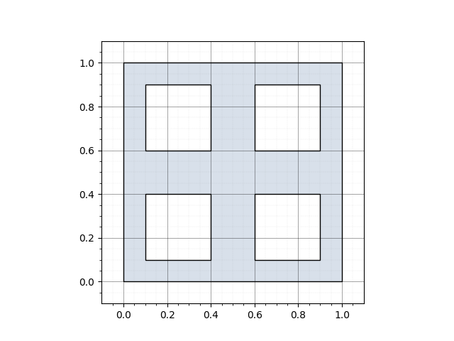
Draw a Geometry
Functions let you quickly visualize the geometries you are
manipulating or export them to an image file.
You can display:
- a standalone geometry,
- a geometry contained in a Feature, or
- all geometries inside a Geolayer.
Display a geometry in a window
Example with a polygon.
Set graticule=True to add major/minor grid lines (default is False):
import geoformat
from tests.data.geometries import polygon_square_with_holes

geoformat.draw_geometry(polygon_square_with_holes, graticule=True)
If a graphical backend is available, a Matplotlib window opens and shows:
Save the figure directly to a file
In headless environments (servers, CI, SSH sessions) there may be no
interactive display.
Pass a file path to path to export the figure without opening a
window.
Optionally set dpi to control resolution:
import geoformat
from tests.data.geometries import polygon_square_with_holes

# Save as a 300 dpi PNG without showing a window
geoformat.draw_geometry(
    polygon_square_with_holes,
    graticule=True,
    path="polygon_output.png",
    dpi=300
)
When path is provided, no interactive window is created---the
image is written directly.
Draw a geometry in a Feature
To render a geometry stored inside a GeoJSON-like feature:
import geoformat
from tests.data.features import feature_katsuragawa

# Show interactively
geoformat.draw_feature(feature_katsuragawa, graticule=True)

# Or export only
geoformat.draw_feature(feature_katsuragawa, path="katsuragawa.png", dpi=200)

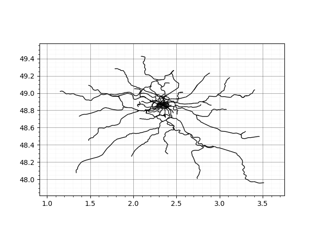
Draw an entire Geolayer
To view or export all geometries of a geolayer:
import geoformat
from tests.data.geolayers import geolayer_idf_reseau_ferre

# Interactive window
geoformat.draw_geolayer(geolayer_idf_reseau_ferre, graticule=True)

# Save to file instead
geoformat.draw_geolayer(geolayer_idf_reseau_ferre,
                        graticule=True,
                        path="idf_reseau_ferre.png",
                        dpi=250)
Summary of new parameters
Parameter Type Default Purpose
path str | PathLike None If set, save the figure to this file and
skip plt.show().
dpi int | float | None None Resolution (dots per inch) when saving
the figure.
Tip:
If you are running on a server or inside a CI pipeline and see
RuntimeError: Interactive display is not available, simply supplypath="output.png"to save the image instead of trying to open a window.
Geometry usefully functions
Area, length, distance, bbox and centroid
Area
import geoformat

geometry = {
    "type": "Polygon",
    "coordinates": [[[273950.31, 6643295.0], [190786.82, 6599267.27], [190786.82, 6467184.09], [44027.73, 6408480.45], [4891.97, 6364452.72], [39135.76, 6335100.9], [-122299.25, 6315533.03], [-141867.12, 6388912.57], [-200570.76, 6388912.57], [-176110.91, 6315533.03], [-151651.06, 6207909.69], [-288626.22, 6183449.84], [-337545.92, 6237261.51], [-513656.83, 6217693.63], [-528332.74, 6163881.96], [-489196.98, 6168773.93], [-469629.1, 6134530.14], [-513656.83, 6119854.23], [-484305.01, 6061150.59], [-450061.22, 6105178.32], [-313086.07, 6056258.63], [-225030.61, 5953527.26], [-249490.46, 5929067.41], [-136975.15, 5826336.04], [-112515.31, 5743172.56], [-73379.55, 5640441.19], [-127191.22, 5699144.83], [-127191.22, 5523033.92], [-195678.79, 5356706.94], [63595.61, 5258867.55], [73379.55, 5293111.33], [210354.7, 5229515.73], [362005.77, 5214839.82], [327761.98, 5307787.24], [464737.13, 5390950.73], [547900.62, 5386058.76], [665307.89, 5327355.12], [719119.56, 5342031.03], [841418.81, 5420302.55], [846310.78, 5479006.19], [782715.17, 5488790.13], [748471.38, 5625765.28], [777823.2, 5718712.71], [768039.26, 5836119.98], [684875.77, 5782308.32], [679983.8, 5860579.83], [758255.32, 5938851.35], [841418.81, 6031798.78], [851202.75, 6114962.26], [914798.35, 6271505.3], [748471.38, 6291073.18], [714227.59, 6354668.78], [635956.08, 6344884.84], [513656.83, 6447616.21], [322870.01, 6555239.55], [273950.31, 6643295.0]]]
}

geom_area = geoformat.geometry_area(geometry)

print(geom_area)

# >>> 1126425592118.5842
Length
import geoformat

geometry = {
    "type": "Polygon",
    "coordinates": [[[273950.31, 6643295.0], [190786.82, 6599267.27], [190786.82, 6467184.09], [44027.73, 6408480.45], [4891.97, 6364452.72], [39135.76, 6335100.9], [-122299.25, 6315533.03], [-141867.12, 6388912.57], [-200570.76, 6388912.57], [-176110.91, 6315533.03], [-151651.06, 6207909.69], [-288626.22, 6183449.84], [-337545.92, 6237261.51], [-513656.83, 6217693.63], [-528332.74, 6163881.96], [-489196.98, 6168773.93], [-469629.1, 6134530.14], [-513656.83, 6119854.23], [-484305.01, 6061150.59], [-450061.22, 6105178.32], [-313086.07, 6056258.63], [-225030.61, 5953527.26], [-249490.46, 5929067.41], [-136975.15, 5826336.04], [-112515.31, 5743172.56], [-73379.55, 5640441.19], [-127191.22, 5699144.83], [-127191.22, 5523033.92], [-195678.79, 5356706.94], [63595.61, 5258867.55], [73379.55, 5293111.33], [210354.7, 5229515.73], [362005.77, 5214839.82], [327761.98, 5307787.24], [464737.13, 5390950.73], [547900.62, 5386058.76], [665307.89, 5327355.12], [719119.56, 5342031.03], [841418.81, 5420302.55], [846310.78, 5479006.19], [782715.17, 5488790.13], [748471.38, 5625765.28], [777823.2, 5718712.71], [768039.26, 5836119.98], [684875.77, 5782308.32], [679983.8, 5860579.83], [758255.32, 5938851.35], [841418.81, 6031798.78], [851202.75, 6114962.26], [914798.35, 6271505.3], [748471.38, 6291073.18], [714227.59, 6354668.78], [635956.08, 6344884.84], [513656.83, 6447616.21], [322870.01, 6555239.55], [273950.31, 6643295.0]]]
}

geom_length = geoformat.geometry_length(geometry)

print(geom_length)
# >>> 5999094.432367001
Distance
You can compute the distance between two points. There are two types of distance allowed:
- Euclidean
- Manhattan
Bbox
Each geometry has an associated bbox. The bbox represents the minimum bounding rectangle in which the geometry is embedded.
import geoformat

polygon_geometry = {"type": "Polygon", "coordinates": [
    [[2.38, 57.322], [23.194, -20.28], [-120.43, 19.15], [2.38, 57.322]],
    [[-5.21, 23.51], [15.21, -10.81], [-20.51, 1.51], [-5.21, 23.51]],
]}

polygon_bbox = geoformat.geometry_to_bbox(polygon_geometry)

print(polygon_bbox)

# >>> (-120.43, -20.28, 23.194, 57.322)
Centroid
You can get the centroid coordinates, which is the mean of all coordinates of a geometry.
import geoformat

multi_point_coordinates  = [[-155.52, 19.61], [-156.22, 20.74], [-157.97, 21.46]]

multi_point_centroid = geoformat.coordinates_to_centroid(multi_point_coordinates)

print(multi_point_centroid)

# >>> [-156.57000000000002, 20.60333333333333]
Euclidean distance
import geoformat

point_a = (0, 0)
point_b = (1, 1)

print(geoformat.euclidean_distance(point_a, point_b))

# >>> 1.4142135623730951
Manhattan distance
import geoformat

point_a = (0, 0)
point_b = (1, 1)

print(geoformat.manhattan_distance(point_a, point_b))

# >>> 2.0
Reproject
You can reproject an entire Geolayer or a simple geometry. To do that, indicate the input EPSG and the desired EPSG for the output.
Reproject Geometry
import geoformat

point_geometry_4326 = {"type": "Point", "coordinates": [-115.81, 37.24]}

point_geometry_3857 = geoformat.reproject_geometry(point_geometry_4326, 4326, 3857)

print(point_geometry_3857)

# >>> {'type': 'Point', 'coordinates': [-12891910.228769012, 4472612.698469004]}
Reproject Geolayer
In this example, we will transform a geolayer from the Lambert93 projection [EPSG:2154] to the WGS84 coordinate system [EPSG:4326].
import geoformat

region_path = 'data/FRANCE_IGN/REGION_2016_L93.shp'

geolayer = geoformat.shapefile_to_geolayer(region_path)

geolayer = geoformat.reproject_geolayer(geolayer, in_crs=2154, out_crs=4326)

print(geolayer['metadata']['geometry_ref']['crs'])

# >>>4326
Geometry formatting
wkb_to_geometry
You can convert geometry in WKB format to Geoformat geometry.
import geoformat

geoformat_geometry = geoformat.wkb_to_geometry(b"\x00\x00\x00\x00\x01\xc0\\\xf3\xd7\n=p\xa4@B\x9e\xb8Q\xeb\x85\x1f")

print(geoformat_geometry)

# >>>  {"type": "Point", "coordinates": [-115.81, 37.24], "bbox": (-115.81, 37.24, -115.81, 37.24)}
geometry_to_wkb
You can convert Geoformat geometry to WKB format.
import geoformat

wkb_geometry = geoformat.geometry_to_wkb({"type": "Point", "coordinates": [-115.81, 37.24]})

print(wkb_geometry)

# >>> b"\x00\x00\x00\x00\x01\xc0\\\xf3\xd7\n=p\xa4@B\x9e\xb8Q\xeb\x85\x1f"
wkt_to_geometry
From WKT geometry, you can make a conversion to Geoformat geometry.
import geoformat

geoformat_geometry = geoformat.wkt_to_geometry("POINT (-115.81 37.24)")

print(geoformat_geometry)

# >>>  {"type": "Point", "coordinates": [-115.81, 37.24], "bbox": (-115.81, 37.24, -115.81, 37.24)}
geometry_to_wkt
Convert a geometry to WKT.
import geoformat

wkt_geometry = geoformat.geometry_to_wkt({"type": "Point", "coordinates": [-115.81, 37.24]})

print(wkt_geometry)

# >>> "POINT (-115.81 37.24)"
Geometrics manipulations
In this section, we will present the functions for performing geometric operations.
- Generalization
- Merging geometries
- Point on Linestring
- Force rhr
- Multi and single geometry
- Snap to grid
Generalization
Geoformat allows cartographic generalization via the simplify function by allowing the user to choose between two algorithms:
- Ramer-Douglas-Peucker (RDP)
- Visvalingam-Whyatt (VW)
Ramer-Douglas-Peucker
The Ramer-Douglas-Peucker algorithm is a geometric simplification technique that reduces the number of points in a geometry while maintaining its overall shape. It recursively subdivides the polyline, retaining points that exceed a specified distance tolerance.
Advantages:
- Preserves overall shape.
- Efficient for simple or mildly complex geometry.
- Easy to implement.
Disadvantages:
- Can produce suboptimal results for densely packed points.
- Slower for highly complex geometries.
- Fixed tolerance might not suit varying data densities.
import geoformat

loire_geometry = {"type": "LineString", "coordinates": [[-237872.03, 5988382.54], [-209743.21, 5987159.55], [-198124.78, 5976152.62], [-174276.42, 5974318.13], [-154097.05, 5986548.06], [-145536.1, 5998777.98], [-119241.76, 6002446.96], [-104565.85, 6003669.95], [-88055.46, 6004281.45], [-78271.52, 6004281.45], [-66653.09, 6009173.42], [-52588.68, 6009173.42], [-37301.27, 6009173.42], [-32409.3, 6008561.92], [-23236.86, 5996331.99], [-4891.97, 5983490.57], [9172.44, 5977987.11], [18344.89, 5980433.09], [48919.7, 5996943.49], [67264.58, 6001223.96], [91724.43, 6009784.91], [116184.28, 6010396.41], [149205.08, 6032410.27], [155320.04, 6045863.19], [181002.88, 6060539.1], [182225.88, 6071546.03], [194455.8, 6079495.48], [204851.24, 6083775.96], [218915.65, 6089890.92], [245209.99, 6084387.45], [257439.91, 6077049.5], [295352.68, 6051978.15], [307582.6, 6038525.23], [328984.97, 6018957.36], [317366.54, 5998166.48], [342437.89, 5969426.16], [344883.87, 5941297.33], [389523.1, 5912557.01], [409702.47, 5892377.64], [412759.95, 5881982.2], [426824.37, 5861802.83], [447615.24, 5848961.4], [451284.21, 5812271.63], [452507.21, 5782919.81], [448838.23, 5766409.41], [457399.18, 5755402.48], [469017.61, 5738280.59], [465348.63, 5710151.76], [473298.08, 5695475.85], [468406.11, 5678965.45], [461068.15, 5656951.59], [448838.23, 5654811.35], [437066.93, 5651753.87], [436608.31, 5643498.67], [435385.31, 5636772.21], [440583.03, 5624695.16], [434468.07, 5621943.43], [435538.19, 5617815.83], [437831.3, 5613229.61], [435232.44, 5604821.54]]}
loire_simplify_geometry = geoformat.simplify(
    geometry=loire_geometry,
    tolerance=5000,
    algo='RDP'
)

print(loire_simplify_geometry)

# >>> {'type': 'LineString', 'coordinates': [[-237872.03, 5988382.54], [-174276.42, 5974318.13], [-145536.1, 5998777.98], [-37301.27, 6009173.42], [9172.44, 5977987.11], [48919.7, 5996943.49], [116184.28, 6010396.41], [149205.08, 6032410.27], [194455.8, 6079495.48], [218915.65, 6089890.92], [245209.99, 6084387.45], [295352.68, 6051978.15], [328984.97, 6018957.36], [317366.54, 5998166.48], [342437.89, 5969426.16], [344883.87, 5941297.33], [389523.1, 5912557.01], [426824.37, 5861802.83], [447615.24, 5848961.4], [448838.23, 5766409.41], [469017.61, 5738280.59], [465348.63, 5710151.76], [473298.08, 5695475.85], [461068.15, 5656951.59], [437066.93, 5651753.87], [435232.44, 5604821.54]]}
Visvalimgam Whyatt
The Visvalingam-Whyatt algorithm is a geometry simplification method that reduces the number of points while preserving shape. It iteratively removes points based on their "effective area," which is the triangular area formed by a point and its two neighbors. The algorithm removes points with the smallest areas until a desired level of simplification is achieved.
Advantages:
- Better preservation of local features.
- More intuitive elimination based on effective area.
- Adaptive to varying data densities.
Disadvantages:
- Can be slower for large datasets.
- More complex to implement.
- Requires pre-sorting or priority queue for best performance.
import geoformat

france_geometry = {
    "type": "Polygon",
    "coordinates":  [[[273950.31, 6643295.0], [190786.82, 6599267.27], [190786.82, 6467184.09], [44027.73, 6408480.45], [4891.97, 6364452.72], [39135.76, 6335100.9], [-122299.25, 6315533.03], [-141867.12, 6388912.57], [-200570.76, 6388912.57], [-176110.91, 6315533.03], [-151651.06, 6207909.69], [-288626.22, 6183449.84], [-337545.92, 6237261.51], [-513656.83, 6217693.63], [-528332.74, 6163881.96], [-489196.98, 6168773.93], [-469629.1, 6134530.14], [-513656.83, 6119854.23], [-484305.01, 6061150.59], [-450061.22, 6105178.32], [-313086.07, 6056258.63], [-225030.61, 5953527.26], [-249490.46, 5929067.41], [-136975.15, 5826336.04], [-112515.31, 5743172.56], [-73379.55, 5640441.19], [-127191.22, 5699144.83], [-127191.22, 5523033.92], [-195678.79, 5356706.94], [63595.61, 5258867.55], [73379.55, 5293111.33], [210354.7, 5229515.73], [362005.77, 5214839.82], [327761.98, 5307787.24], [464737.13, 5390950.73], [547900.62, 5386058.76], [665307.89, 5327355.12], [719119.56, 5342031.03], [841418.81, 5420302.55], [846310.78, 5479006.19], [782715.17, 5488790.13], [748471.38, 5625765.28], [777823.2, 5718712.71], [768039.26, 5836119.98], [684875.77, 5782308.32], [679983.8, 5860579.83], [758255.32, 5938851.35], [841418.81, 6031798.78], [851202.75, 6114962.26], [914798.35, 6271505.3], [748471.38, 6291073.18], [714227.59, 6354668.78], [635956.08, 6344884.84], [513656.83, 6447616.21], [322870.01, 6555239.55], [273950.31, 6643295.0]]],
}
france_simplify_geometry = geoformat.simplify(
    geometry=france_geometry,
    tolerance=3000000000,
    algo='VW'
)

print(france_simplify_geometry)

# >>> {'type': 'Polygon', 'coordinates': [[[273950.31, 6643295.0], [190786.82, 6599267.27], [190786.82, 6467184.09], [44027.73, 6408480.45], [39135.76, 6335100.9], [-122299.25, 6315533.03], [-151651.06, 6207909.69], [-288626.22, 6183449.84], [-337545.92, 6237261.51], [-513656.83, 6217693.63], [-469629.1, 6134530.14], [-313086.07, 6056258.63], [-225030.61, 5953527.26], [-136975.15, 5826336.04], [-127191.22, 5699144.83], [-127191.22, 5523033.92], [-195678.79, 5356706.94], [63595.61, 5258867.55], [210354.7, 5229515.73], [362005.77, 5214839.82], [327761.98, 5307787.24], [464737.13, 5390950.73], [547900.62, 5386058.76], [665307.89, 5327355.12], [719119.56, 5342031.03], [841418.81, 5420302.55], [782715.17, 5488790.13], [748471.38, 5625765.28], [777823.2, 5718712.71], [768039.26, 5836119.98], [684875.77, 5782308.32], [679983.8, 5860579.83], [758255.32, 5938851.35], [841418.81, 6031798.78], [851202.75, 6114962.26], [914798.35, 6271505.3], [748471.38, 6291073.18], [635956.08, 6344884.84], [513656.83, 6447616.21], [322870.01, 6555239.55], [273950.31, 6643295.0]]]}
Merging geometries
LineString merging
This function is similar than ST_LineMerge from Postgis.
You can optionaly choose to not allow reverse geometry when setting directed to True. This is useful when dealing
with a road network where the direction in which the coordinates are encoded is important for defining the direction of
traffic.)
import geoformat

multi_line_geometry = {
            "type": "MultiLineString",
            "coordinates": [
                [[2, 3], [5, 2], [8, 4]],
                [[5, 9], [3, 6]],
                [[3, 6], [2, 3]],
                [[8, 4], [9, 7], [5, 9]],
            ],
        }

line_merged_geometry = geoformat.line_merge(geometry=multi_line_geometry)

print(line_merged_geometry)

# >>> {"type": "LineString", "coordinates": [[8, 4], [9, 7], [5, 9], [3, 6], [2, 3], [5, 2], [8, 4]]}
Example with directed linestring.
import geoformat

multi_line_geometry = {
  "type": "MultiLineString",
  "coordinates": [
    [[0, 0], [0, 10],],
    [[0, 10], [0, 20]],
    [[0, 30], [0, 20]]
    ]
}

line_merged_geometry = geoformat.line_merge(geometry=multi_line_geometry, directed=True)

print(line_merged_geometry)

# >>> {'type': 'MultiLineString', 'coordinates': [[[0, 0], [0, 10], [0, 20]], [[0, 30], [0, 20]]]}
Geometry merging
Return the result of merging two different geometries by adding them together. Please note that this function does not "union" two geometries that intersect. It simply adds one geometry to another.
Here is an example of merging combinations:
-
Single AND Single
Point+Point=MultiPointLineString+LineString=MultiLineStringPolygon+Polygon=MultiPolygon
-
Single AND Multi
Point+MultiPoint=MultiPointLineString+MultiLineString=MultiLineStringPolygon+MultiPolygon=MultiPolygon
-
Mixed Geometries Types and GeometryCollection
Point+Polygon=GeometryCollection(Point, Polygon)GeometryCollection(Polygon + LineString)+LineSting=GeometryCollection(Polygon + MultiLineString)GeometryCollection(MultiPolygon, LineString), GeometryCollection(MultiPoint, LineString)=GeometryCollection(MultiPolygon, MultiLineString, MultiPoint)
import geoformat

geometry_a = {"type": "Point", "coordinates": [-115.81, 37.24]}
geometry_b = {"type": "Polygon", "coordinates": [
    [[2.38, 57.322], [23.194, -20.28], [-120.43, 19.15], [2.38, 57.322]],
    [[-5.21, 23.51], [15.21, -10.81], [-20.51, 1.51], [-5.21, 23.51]],
]}

merged_geometry = geoformat.merge_geometries(geometry_a, geometry_b, bbox=False)

print(merged_geometry)

# >>> {'type': 'GeometryCollection', 'geometries': [{'type': 'Point', 'coordinates': [-115.81, 37.24]}, {'type': 'Polygon', 'coordinates': [[[2.38, 57.322], [23.194, -20.28], [-120.43, 19.15], [2.38, 57.322]], [[-5.21, 23.51], [15.21, -10.81], [-20.51, 1.51], [-5.21, 23.51]]]}]}
Point on Linestring
If you want to add point(s) on a linestring at a given distance, points_on_linestring_distance is for you. You can optionally add an offset that will shift each point created to the left (positive offset) or right (negative offset) of the line depending on the direction of the line.
import geoformat

linestring_geometry =  {
    "type": "LineString",
    "coordinates": [[-10, -10], [-10, 10], [10, 10]],
}

point_on_linestring_gen = geoformat.points_on_linestring_distance(linestring_geometry, 5)

for point in point_on_linestring_gen:
    print(point)

# >>> {'type': 'Point', 'coordinates': [-10, -10]}
# >>> {'type': 'Point', 'coordinates': [-10, -5]}
# >>> {'type': 'Point', 'coordinates': [-10, 0]}
# >>> {'type': 'Point', 'coordinates': [-10, 5]}
# >>> {'type': 'Point', 'coordinates': [-10, 10]}
# >>> {'type': 'Point', 'coordinates': [-5.0, 10.0]}
# >>> {'type': 'Point', 'coordinates': [0.0, 10.0]}
# >>> {'type': 'Point', 'coordinates': [5.0, 10.0]}
# >>> {'type': 'Point', 'coordinates': [10.0, 10.0]}
Same with offset:
import geoformat

linestring_geometry =  {
    "type": "LineString",
    "coordinates": [[-10, -10], [-10, 10], [10, 10]],
}

point_on_linestring_offset_gen = geoformat.points_on_linestring_distance(linestring_geometry, 5, -10)

for point in point_on_linestring_offset_gen:
    print(point)

# >>> {'type': 'Point', 'coordinates': [-20.0, -10.0]}
# >>> {'type': 'Point', 'coordinates': [-20.0, -5.0]}
# >>> {'type': 'Point', 'coordinates': [-20.0, 0.0]}
# >>> {'type': 'Point', 'coordinates': [-20.0, 5.0]}
# >>> {'type': 'Point', 'coordinates': [-20.0, 10.0]}
# >>> {'type': 'Point', 'coordinates': [-5.0, 0.0]}
# >>> {'type': 'Point', 'coordinates': [0.0, 0.0]}
# >>> {'type': 'Point', 'coordinates': [5.0, 0.0]}
# >>> {'type': 'Point', 'coordinates': [10.0, 0.0]}
Force rhr
Force the orientation of the vertices in a polygon to follow the Right-Hand-Rule, in which the area bounded by the polygon is to the right of the boundary. Specifically, the exterior ring is oriented in a clockwise direction, and the interior rings are oriented in a counter-clockwise direction.
import geoformat

polygon = {'type': 'Polygon',
           'coordinates': [[[0, 0], [5, 0], [0, 5], [0, 0]],
                           [[1, 1], [1, 3], [3, 1], [1, 1]]]}


polygon_rhr = geoformat.force_rhr(polygon)

print(polygon_rhr)

# >>> {'type': 'Polygon', 'coordinates': [[[0, 0], [0, 5], [5, 0], [0, 0]], [[1, 1], [3, 1], [1, 3], [1, 1]]]}
Multi and single geometry
As you know, there are single and multi geometries:
Single geometry:
PointLineStringPolygon
Multi geometry:
MultiPointMultiLineStringMultiPolygon
There are two functions for switching from one to the other: single_geometry_to_multi_geometry and multi_geometry_to_single_geometry.
single_geometry_to_multi_geometry
import geoformat

polygon = {"type": "Polygon", "coordinates": [
        [[2.38, 57.322], [23.194, -20.28], [-120.43, 19.15], [2.38, 57.322]],
        [[-5.21, 23.51], [15.21, -10.81], [-20.51, 1.51], [-5.21, 23.51]],
    ]
}

multi_polygon = geoformat.single_geometry_to_multi_geometry(polygon)

print(multi_polygon)

# >>> {'type': 'MultiPolygon', 'coordinates': [[[[2.38, 57.322], [23.194, -20.28], [-120.43, 19.15], [2.38, 57.322]], [[-5.21, 23.51], [15.21, -10.81], [-20.51, 1.51], [-5.21, 23.51]]]]}
multi_geometry_to_single_geometry
This function returns a generator with single geometries of multi geometry in each iteration.
import geoformat

multi_geometry = {
    "type": "MultiLineString",
    "coordinates": [
        [[3.75, 9.25], [-130.95, 1.52]],
        [[23.15, -34.25], [-1.35, -4.65], [3.45, 77.95]],
    ],
}

for geometry in geoformat.multi_geometry_to_single_geometry(multi_geometry):
    print(geometry)

# >>> {'type': 'LineString', 'coordinates': [[3.75, 9.25], [-130.95, 1.52]]}
# >>> {'type': 'LineString', 'coordinates': [[23.15, -34.25], [-1.35, -4.65], [3.45, 77.95]]}
Snap to grid
snap_to_grid snaps all vertices of a geometry to the nearest point on a regular grid of a given cell size.
This is useful for reducing coordinate precision, removing near-duplicate vertices that arise from floating-point noise,
or aligning geometries that should share boundaries.
The optional delete_collinear_vertex parameter removes vertices that lie on a straight line between their two
neighbours after snapping, further reducing the number of points.
import geoformat

# Snap a Point to the nearest integer grid (size=1)
point = {"type": "Point", "coordinates": [257439.91, 6077049.5]}

snapped_point = geoformat.snap_to_grid(geometry=point, size=1)

print(snapped_point)

# >>> {'type': 'Point', 'coordinates': [257440.0, 6077049.0]}
import geoformat

# Snap a LineString — intermediate vertices that land on the same grid point
# are merged into one (duplicate consecutive coordinates are removed)
linestring = {
    "type": "LineString",
    "coordinates": [[1, 0], [2.1, 0.9], [3, 2], [3.1, 2.25], [3.9, 3.1], [5, 4]],
}

snapped_linestring = geoformat.snap_to_grid(geometry=linestring, size=1)

print(snapped_linestring)

# >>> {'type': 'LineString', 'coordinates': [[1.0, 0.0], [2.0, 1.0], [3.0, 2.0], [4.0, 3.0], [5.0, 4.0]]}
With delete_collinear_vertex=True, vertices that are perfectly aligned after snapping are also removed:
import geoformat

linestring = {
    "type": "LineString",
    "coordinates": [[1, 0], [2.1, 0.9], [3, 2], [3.1, 2.25], [3.9, 3.1], [5, 4]],
}

snapped_linestring = geoformat.snap_to_grid(
    geometry=linestring,
    size=1,
    delete_collinear_vertex=True,
)

print(snapped_linestring)

# >>> {'type': 'LineString', 'coordinates': [[1, 0], [5, 4]]}
Low level geometrics objects
There are low-level geometric objects that compose or describe the geometries generally used in GIS (point, linestring, polygon, etc.). It is with these low-level geometric objects that we calculate the existing interactions between the GIS geometries. For more details, refer to the technical documentation : Geoformat Technical Description [WIP].
point, segment and bbox
point_intersects_point
Check if two points are similar.
import geoformat

point_a = (10, 10)
point_b = (10, 10)
pt_a_int_pt_b = geoformat.point_intersects_point(point_a, point_b)

print(pt_a_int_pt_b)

# >>> True
point_intersects_segment
Check if a point intersects a segment.
import geoformat

point =  (0, 0)
segment = ((-10, -10), (10, 10))

pt_int_seg = geoformat.point_intersects_segment(point, segment)

print(pt_int_seg)

# >>> True
point_intersects_bbox
Check if a point is in a bounding box (bbox).
import geoformat

point =  (0, 0)
bbox = (-10, -10, 10, 10)

pt_int_bbx = geoformat.point_intersects_bbox(point, bbox)

print(pt_int_bbx)

# >>> True
segment_intersects_segment
Check if a segment intersects another segment.
import geoformat

segment_a = ((10, 10), (-10, -10))
segment_b = ((-10, 10), (10, -10))

seg_int_seg = geoformat.segment_intersects_segment(segment_a, segment_b)

print(seg_int_seg)

# >>> True
segment_intersects_bbox
Check if a segment intersects a bounding box (bbox).
import geoformat

segment = ((-2, 0), (2, 0))
bbox = (-10, -10, 10, 10)

seg_int_bbx = geoformat.segment_intersects_bbox(segment, bbox)

print(seg_int_bbx)

# >>> True
bbox_intersects_bbox
Check if two bounding boxes (bbox) intersect.
import geoformat

bbox_a = (-10, -10, 10, 10)
bbox_b = (-10, -10, 10, 10)

bbx_int_bbx = geoformat.bbox_intersects_bbox(bbox_a, bbox_b)

print(bbx_int_bbx)

# >>> True
ccw_or_cw_segments
Check if two continuous segments are clockwise ('CW') or counterclockwise ('CCW').
Counter-clockwise example:
import geoformat

segment_a = ((-5, -5), (5, 5))
segment_b =  ((5, 5), (-1, 2))

seg_a_and_seg_b_clock_wise = geoformat.ccw_or_cw_segments(segment_a, segment_b)

print(seg_a_and_seg_b_clock_wise)

# >>> 'CCW'
Clockwise example:
import geoformat

segment_a = ((-5, -5), (5, 5))
segment_b = ((5, 5), (5, -5))

seg_a_and_seg_b_clock_wise = geoformat.ccw_or_cw_segments(segment_a, segment_b)

print(seg_a_and_seg_b_clock_wise)

# >>> 'CCW'
point_position_segment
Give the position of a point with respect to the direction of a segment. There are three possible positions:
LEFTRIGHTNEITHER
Left example :
import geoformat

segment = ((-5, -5), (5, 5))
point =  (-1, 2)

pt_vs_seg_position = geoformat.point_position_segment(point, segment)

print(pt_vs_seg_position)

# >>> 'LEFT'
right example :
import geoformat

segment = ((-5, -5), (5, 5))
point = (5, -5)

pt_vs_seg_position = geoformat.point_position_segment(point, segment)

print(pt_vs_seg_position)

# >>> 'RIGHT'
neither example :
import geoformat

segment = ((-5, -5), (5, 5))
point = (10, 10)

pt_vs_seg_position = geoformat.point_position_segment(point, segment)

print(pt_vs_seg_position)

# >>> 'NEITHER'
bbox_expand
Expand a bounding box (bbox).
import geoformat

bbox = (-1, -1, 1, 1)
bbox_expanded = geoformat.bbox_expand(bbox, 10)

print(bbox_expanded)

# >>> (-11, -11, 11, 11)
bbox_union
Union two bounding boxes (bbox).
import geoformat

bbox_a = (-10, -10, 0, 0)
bbox_b = (0, 0, 10, 10)

bbox_unioned = geoformat.bbox_union(bbox_a, bbox_b)

print(bbox_unioned)

# >>> (-10, -10, 10, 10)
point_bbox_position
Gives the position of a point relative to a bounding box (bbox). This function returns 2 main pieces of information:
- If the point is localized in the Exterior, Interior, or on the bbox Boundary
- The place of the frame where the point is located (NW, N, NE, W, E, SW, S, SE)
   NW  |   N  |  NE
-------+------+-------
    W  | bbox |   E
-------+------+-------
   SW  |   S  |  SE
Point localized on the bbox North-West (NW) corner.
import geoformat

point = (-10, 10)
bbox = (-10, -10, 10, 10)

point_position = geoformat.point_bbox_position(point, bbox)

print(point_position)

# >>> ('Boundary', 'NW')
Point localised in bounding boxes (bbox).
import geoformat

point = (0, 0)
bbox = (-10, -10, 10, 10)

point_position = geoformat.point_bbox_position(point, bbox)

print(point_position)

# >>> ('Interior', None)
Point localised in South (S) of bounding boxes (bbox).
import geoformat

point = (0, -11)
bbox = (-10, -10, 10, 10)

point_position = geoformat.point_bbox_position(point, bbox)

print(point_position)

# >>> ('Exterior', 'S')
random
These three low-level geometric objects can be created randomly. You must specify a bounding box (bbox) within which these objects will be created. Optionally, you can specify the number of digits after the decimal point for each coordinate.
####### random_point
import geoformat

bbox = (-180, -90, 180, 90)
random_point = geoformat.random_point(bbox)

print(random_point)

# >>> (59.89, 1.04)
####### random_segment
import geoformat

bbox = (-180, -90, 180, 90)
random_segment = geoformat.random_segment(bbox)

print(random_segment)

# >>> ((-155.78, 82.55), (99.11, -17.46))
####### random_bbox
import geoformat

bbox = (-180, -90, 180, 90)
random_bbox = geoformat.random_bbox(bbox)

print(random_bbox)

# >>> (-63.44, -87.6, -16.79, 15.78)
Line
Geoformat lets you use the concept of a line.
A line is an infinite, one-dimensional entity made up of an infinite succession of aligned points. It is defined by its constituent points as a mathematical equation in the form: y = mx + c
line_parameters
A line is defined by two pieces of information:
- slope: characterizes the slope of the line. (if the line is vertical, this parameter is 'VERTICAL')
- intercept: is the line y-intercept to the origin.
Example of a basic line:
import geoformat

segment = ((645285, 6779558), (647006, 6779454))

line_param = geoformat.line_parameters(segment)

print(line_param)

# >>> {'slope': -0.06042998256827426, 'intercept': 6818552.5613015685}
example of horizontal line :
import geoformat

segment = ((-5, 1), (5, 1))

line_param = geoformat.line_parameters(segment)

print(line_param)

# >>> {'slope': 0.0, 'intercept': 1.0}
example of vertical line :
import geoformat

segment = ((0, -5), (0, 5))

line_param = geoformat.line_parameters(segment)

print(line_param)

# >>> {'slope': 'VERTICAL', 'intercept': 0.0}
perpendicular_line_parameters_at_point
Return the perpendicular line parameters to a given point on a line.
import geoformat

line_param = {'slope': 0.0, 'intercept': 0.0}
point = (0, 0)

perpendicular_line_param = geoformat.perpendicular_line_parameters_at_point(line_param, point)

print(perpendicular_line_param)

# >>> {'slope': 'VERTICAL', 'intercept': 0.}
point_at_distance_with_line_parameters
To create a point on a line at a distance from a reference point on the line.
import geoformat

start_point = (0, 0)
line_parameters =  {'slope': 1, 'intercept': 0}
distance = 5

point_at_distance = geoformat.point_at_distance_with_line_parameters(start_point, line_parameters, distance)

print(point_at_distance)

# >>> (3.5355339059327373, 3.5355339059327373)
crossing_point_from_lines_parameters
How to find the crossing point between two lines?
import geoformat

line_parameter_a = {'slope': 1, 'intercept': -2}
line_parameter_b = {'slope': -1, 'intercept': -3.}

crossing_point = geoformat.crossing_point_from_lines_parameters(line_parameter_a, line_parameter_b)

print(crossing_point)

# >>> (-0.5, -2.5)
Geometry Index and Matrix
Index and matrix allow for speeding up access to geometry for some geoprocessing.
Geometry Index
Grid index
You can create a grid index.
import geoformat

from tests.data.geolayers import geolayer_for_index

geolayer_grd_idx = geoformat.create_grid_index(geolayer_for_index)

print(geolayer_grd_idx)

# >>> {'metadata': {'type': 'grid', 'mesh_size': 15.093333333333334, 'x_grid_origin': 0, 'y_grid_origin': 0, 'grid_precision': None}, 'index': {(-1, 0): [0, 1], (0, 0): [0, 1], (-1, -1): [1, 2], (0, -1): [1]}}
Geometry Matrix
Adjacency matrix
import geoformat

from tests.data.geolayers import geolayer_grid_3_3

adjacency_mtx = geoformat.create_adjacency_matrix(geolayer_grid_3_3)

print(adjacency_mtx)

# >>> {'matrix': {0: {1, 3, 4}, 1: {0, 2, 3, 4, 5}, 2: {1, 4, 5}, 3: {0, 1, 4, 6, 7}, 4: {0, 1, 2, 3, 5, 6, 7, 8}, 5: {1, 2, 4, 7, 8}, 6: {3, 4, 7}, 7: {3, 4, 5, 6, 8}, 8: {4, 5, 7}}, 'metadata': {'type': 'adjacency'}}
Attributes usefully functions
Attribute data is the second component of the information stored in a Geolayer. Here, we'll take a look at the main functions for making the most of the attribute information contained in a Geolayer.
Attributes index
The best way to access attribute data quickly and repeatedly is to create an attribute index.
For the moment, only a hash table index is available via the function: create_attribute_index.
To associate the index created with a geolayer, use the add_attribute_index function.
import geoformat

geolayer = geoformat.geojson_to_geolayer('data/doc/dept_population_extract.geojson')

geolayer_index = geoformat.create_attribute_index(geolayer, 'INSEE_REG')

print(geolayer_index)

geolayer = geoformat.add_attributes_index(geolayer, 'INSEE_REG', geolayer_index)

# >>> {'metadata': {'type': 'hashtable'}, 'index': {'75': [0], '52': [1], '32': [2]}}
Join geolayer attributes
Initially, the data is stored in a geolayer. Sometimes it's more practical to store data in several geolayers, and often we want to exchange/combine data between several geolayers. Attribute joins enable us to link one geolayer to another by means of a column containing information they have in common.
Geoformat offers four different types of attribute joins:
- Full join
- Inner join
- Left join
- Right join
The parameters can be transposed from one type to another, but the result in terms of returned entities will vary (see examples below).
field_name_filter_aorfield_name_filter_b: allows you to keep in the output geolayer only the fields of the specified geolayer.rename_output_field_from_geolayer_aorrename_output_field_from_geolayer_b: renames fields from input geolayer in the output geolayer. By default, renaming is automatic when a duplicate field name is detected.geometry_ref: A geolayer can only contain one geometry field, so the user must specify the geometry of which geolayer to keep. By default, the geometry fromgeolayer_ais kept (except forjoin_rightwheregeolayer_bis the default value). If you want to keep the geometry of the second geolayer, just indicategeolayer_bfor this parameter.
full join
The join_full function keeps the entirety of the features of each of the two geolayers to be joined.
If there is no matching for a feature in the other geolayer, the fields in the other geolayer will have a None value.
       *~~*   *~~*
     *~~~~~*~~*~~~~~*
    *~~A~~*~~~~*~~B~~*
    *~~~~~*~~~~*~~~~~*
     *~~~~~*~~*~~~~~*
        *~~*  *~~*
import geoformat

from tests.data.geolayers import feature_list_data_and_geometry_geolayer_2
from tests.data.geolayers import feature_list_dpt_data_pop_geolayer

geolayer_full_join = geoformat.join_full(
    geolayer_a=feature_list_data_and_geometry_geolayer_2,
    geolayer_b=feature_list_dpt_data_pop_geolayer,
    on_field_a="CODE_DEPT",
    on_field_b="CODE_DEPT",
    output_geolayer_name= "FRANCE_DPT_FULL_JOIN",
)

print(geoformat.print_features_data_table(geolayer_full_join))

# >>>
# +--------+-----------+-------------+------------+-----------+------------+---------+---------+---------+--------------------------------+
# | i_feat | CODE_DEPT | NOM_DEPT    | CODE_DEPT1 | INSEE_REG | POPULATION | AREA    | DENSITY | type    | coordinates                    |
# +========+===========+=============+============+===========+============+=========+=========+=========+================================+
# | 0      | 53        | MAYENNE     | 53         | 52        | 307445     | 5208.37 | 59.03   | Polygon | [[[399495.0, 6830885.0] ...]]] |
# | 1      | 02        | AISNE       | 02         | 32        | 534490     | 7418.97 | 72.04   | Polygon | [[[776081.0, 6923412.0] ...]]] |
# | 2      | 02        | AISNE       | 02         | 32        | 534490     | 7418.97 | 72.04   | Polygon | [[[776081.0, 6923412.0] ...]]] |
# | 3      | 70        | HAUTE-SAONE | None       | None      | None       | None    | None    | Polygon | [[[986052.0, 6752778.0] ...]]] |
# | 4      | None      | None        | 87         | 75        | 374426     | 5549.31 | 67.47   | None    | None                           |
# | 5      | 53        | MAYENNE     | 53         | 52        | 307445     | 5208.37 | 59.03   | Polygon | [[[399495.0, 6830885.0] ...]]] |
# | 6      | 02        | AISNE       | 02         | 32        | 534490     | 7418.97 | 72.04   | Polygon | [[[776081.0, 6923412.0] ...]]] |
# | 7      | 02        | AISNE       | 02         | 32        | 534490     | 7418.97 | 72.04   | Polygon | [[[776081.0, 6923412.0] ...]]] |
# +--------+-----------+-------------+------------+-----------+------------+---------+---------+---------+--------------------------------+
join
On the other hand, join will only keep entities that are related to each other between two geolayers.
       *  *   *  *
     *     *~~*     *
    *  A  *~~~~*  B  *
    *     *~~~~*     *
     *     *~~*     *
        *  *  *  *
import geoformat

from tests.data.geolayers import feature_list_data_and_geometry_geolayer_2
from tests.data.geolayers import feature_list_dpt_data_pop_geolayer

geolayer_join = geoformat.join(
    geolayer_a=feature_list_data_and_geometry_geolayer_2,
    geolayer_b=feature_list_dpt_data_pop_geolayer,
    on_field_a="CODE_DEPT",
    on_field_b="CODE_DEPT",
    output_geolayer_name= "FRANCE_DPT_FULL_JOIN",
)

print(geoformat.print_features_data_table(geolayer_join))

# >>>
# +--------+-----------+----------+------------+-----------+------------+---------+---------+---------+--------------------------------+
# | i_feat | CODE_DEPT | NOM_DEPT | CODE_DEPT1 | INSEE_REG | POPULATION | AREA    | DENSITY | type    | coordinates                    |
# +========+===========+==========+============+===========+============+=========+=========+=========+================================+
# | 0      | 53        | MAYENNE  | 53         | 52        | 307445     | 5208.37 | 59.03   | Polygon | [[[399495.0, 6830885.0] ...]]] |
# | 1      | 02        | AISNE    | 02         | 32        | 534490     | 7418.97 | 72.04   | Polygon | [[[776081.0, 6923412.0] ...]]] |
# | 2      | 02        | AISNE    | 02         | 32        | 534490     | 7418.97 | 72.04   | Polygon | [[[776081.0, 6923412.0] ...]]] |
# +--------+-----------+----------+------------+-----------+------------+---------+---------+---------+--------------------------------+
import geoformat

from tests.data.geolayers import feature_list_data_and_geometry_geolayer
from tests.data.geolayers import feature_list_dpt_data_pop_geolayer

geolayer_full_join = geoformat.join(
    geolayer_a=feature_list_data_and_geometry_geolayer,
    geolayer_b=feature_list_dpt_data_pop_geolayer,
    on_field_a="CODE_DEPT",
    on_field_b="CODE_DEPT",
    output_geolayer_name= "FRANCE_DPT_JOIN",
)

print(geoformat.print_features_data_table(geolayer_full_join))

# >>>
# +--------+-----------+----------+------------+-----------+------------+---------+---------+---------+--------------------------------+
# | i_feat | CODE_DEPT | NOM_DEPT | CODE_DEPT1 | INSEE_REG | POPULATION | AREA    | DENSITY | type    | coordinates                    |
# +========+===========+==========+============+===========+============+=========+=========+=========+================================+
# | 0      | 53        | MAYENNE  | 53         | 52        | 307445     | 5208.37 | 59.03   | Polygon | [[[399495.0, 6830885.0] ...]]] |
# | 1      | 02        | AISNE    | 02         | 32        | 534490     | 7418.97 | 72.04   | Polygon | [[[776081.0, 6923412.0] ...]]] |
# +--------+-----------+----------+------------+-----------+------------+---------+---------+---------+--------------------------------+
left join
The join_left function will keep all the features of the left geolayer and join them to the right geolayer.
If an entity on the left corresponds to several entities on the right, then the entity on the left will be duplicated as many times.
If there is no matching for a feature in the other geolayer, the fields in the other geolayer will have a None value.
       *~~*   *  *
     *~~~~~*~~*     *
    *~~A~~*~~~~*  B  *
    *~~~~~*~~~~*     *
     *~~~~~*~~*     *
        *~~*  *  *
import geoformat

from tests.data.geolayers import feature_list_data_and_geometry_geolayer_2
from tests.data.geolayers import feature_list_dpt_data_pop_geolayer

geolayer_left_join = geoformat.join_left(
    geolayer_a=feature_list_data_and_geometry_geolayer_2,
    geolayer_b=feature_list_dpt_data_pop_geolayer,
    on_field_a="CODE_DEPT",
    on_field_b="CODE_DEPT",
    output_geolayer_name= "FRANCE_DPT_LEFT_JOIN",
    field_name_filter_a=['CODE_DEPT', 'NOM_DEPT'],
    field_name_filter_b=['INSEE_REG', 'POPULATION', 'AREA', 'DENSITY']
)

print(geoformat.print_features_data_table(geolayer_left_join))

# >>>
# +--------+-----------+-------------+-----------+------------+---------+---------+---------+--------------------------------+
# | i_feat | CODE_DEPT | NOM_DEPT    | INSEE_REG | POPULATION | AREA    | DENSITY | type    | coordinates                    |
# +========+===========+=============+===========+============+=========+=========+=========+================================+
# | 0      | 53        | MAYENNE     | 52        | 307445     | 5208.37 | 59.03   | Polygon | [[[399495.0, 6830885.0] ...]]] |
# | 1      | 02        | AISNE       | 32        | 534490     | 7418.97 | 72.04   | Polygon | [[[776081.0, 6923412.0] ...]]] |
# | 2      | 02        | AISNE       | 32        | 534490     | 7418.97 | 72.04   | Polygon | [[[776081.0, 6923412.0] ...]]] |
# | 3      | 70        | HAUTE-SAONE | None      | None       | None    | None    | Polygon | [[[986052.0, 6752778.0] ...]]] |
# +--------+-----------+-------------+-----------+------------+---------+---------+---------+--------------------------------+
right join
The join_right function will keep all the features of the right geolayer and join them to the left geolayer.
If an entity on the right corresponds to several entities on the left, then the entity on the right will be duplicated as many times.
If there is no matching for a feature in the other geolayer, the fields in the other geolayer will have a None value.
       *  *   *~~*
     *     *~~*~~~~~*
    *  A  *~~~~*~~B~~*
    *     *~~~~*~~~~~*
     *     *~~*~~~~~*
        *  *  *~~*
import geoformat

from tests.data.geolayers import feature_list_data_and_geometry_geolayer_2
from tests.data.geolayers import feature_list_dpt_data_pop_geolayer

geolayer_right_join = geoformat.join_right(
    geolayer_a=feature_list_data_and_geometry_geolayer_2,
    geolayer_b=feature_list_dpt_data_pop_geolayer,
    on_field_a="CODE_DEPT",
    on_field_b="CODE_DEPT",
    output_geolayer_name= "FRANCE_DPT_LEFT_JOIN",
    field_name_filter_a=['CODE_DEPT', 'NOM_DEPT'],
    field_name_filter_b=['AREA', 'DENSITY'],
    rename_output_field_from_geolayer_a={'CODE_DEPT': 'id', 'NOM_DEPT': 'name'},
    rename_output_field_from_geolayer_b={'AREA': 'area', 'DENSITY': 'density'},
    geometry_ref='geolayer_a'
)

print(geoformat.print_features_data_table(geolayer_right_join))

# >>>
# +--------+----+---------+---------+---------+---------+--------------------------------+
# | i_feat | id | name    | area    | density | type    | coordinates                    |
# +========+====+=========+=========+=========+=========+================================+
# | 0      | None| None    | 5549.31 | 67.47   | None    | None                           |
# | 1      | 53 | MAYENNE | 5208.37 | 59.03   | Polygon | [[[399495.0, 6830885.0] ...]]] |
# | 2      | 02 | AISNE   | 7418.97 | 72.04   | Polygon | [[[776081.0, 6923412.0] ...]]] |
# | 3      | 02 | AISNE   | 7418.97 | 72.04   | Polygon | [[[776081.0, 6923412.0] ...]]] |
# +--------+----+---------+---------+---------+---------+--------------------------------+
Clause functions
Similar to SQL language, the purpose of clauses is to find, sort, and group data within a geolayer.
Each function returns a list of feature identifiers corresponding to what the user is looking for.
From the result, with the function create_geolayer_from_i_feat_list, a new geolayer can be reconstructed.
clause where
The clause_where function returns feature identifiers corresponding to the desired value of a field according to a given predicate.
Here is the list of predicates managed by the function:
=<><>LIKEBETWEENISIS NOT
import geoformat

from tests.data.geolayers import geolayer_fr_dept_data_only

i_feat_list = geoformat.clause_where(geolayer_fr_dept_data_only, 'NOM_DEPT', '=', 'MEUSE')

print(i_feat_list)

meuse_geolayer = geoformat.create_geolayer_from_i_feat_list(geolayer_fr_dept_data_only, i_feat_list)

print(geoformat.print_features_data_table(meuse_geolayer))

# >>> [15]
# >>>
# +--------+-----------+----------+
# | i_feat | CODE_DEPT | NOM_DEPT |
# +========+===========+==========+
# | 0      | 55        | MEUSE    |
# +--------+-----------+----------+
clause group by
The clause_group_by clause is used to highlight the unique occurrences of one or more fields in a geolayer.
In return, the function returns a dictionary with a tuple of unique values as the key and a list of feature identifiers as the value.
import geoformat

from tests.data.geolayers import geolayer_fr_dept_population

clause_group_by_dict = geoformat.clause_group_by(geolayer_fr_dept_population, 'INSEE_REG')

print(clause_group_by_dict)

for insee_reg_value, i_feat_list in clause_group_by_dict.items():
    insee_reg_geolayer =  geoformat.create_geolayer_from_i_feat_list(geolayer_fr_dept_population, i_feat_list)
    print(geoformat.print_features_data_table(insee_reg_geolayer))

# >>> {('76',): [0, 8, 28, 31, 36, 40, 42, 47, 48, 57, 77, 79, 92], ('75',): [1, 13, 16, 22, 25, 26, 32, 56, 64, 75, 83, 87], ('84',): [2, 6, 20, 30, 35, 44, 55, 66, 74, 76, 78, 80], ('32',): [3, 21, 46, 59, 67], ('44',): [4, 5, 15, 18, 24, 39, 41, 45, 54, 58], ('93',): [7, 49, 82, 84, 89, 93], ('27',): [9, 14, 27, 34, 60, 62, 69, 72], ('52',): [10, 29, 50, 61, 88], ('11',): [11, 43, 68, 71, 90, 91, 94, 95], ('28',): [12, 17, 37, 38, 70], ('24',): [19, 23, 33, 53, 81, 85], ('53',): [51, 63, 65, 73], ('94',): [52, 86]}
# >>>
# +--------+-----------+-----------+------------+---------+---------+
# | i_feat | CODE_DEPT | INSEE_REG | POPULATION | AREA    | DENSITY |
# +========+===========+===========+============+=========+=========+
# | 0      | 32        | 76        | 191091     | 6304.33 | 30.31   |
# | 1      | 31        | 76        | 1362672    | 6364.82 | 214.09  |
# | 2      | 82        | 76        | 258349     | 3731.0  | 69.24   |
# | 3      | 12        | 76        | 279206     | 8770.69 | 31.83   |
# | 4      | 81        | 76        | 387890     | 5785.79 | 67.04   |
# | 5      | 30        | 76        | 744178     | 5874.71 | 126.67  |
# | 6      | 11        | 76        | 370260     | 6351.35 | 58.3    |
# | 7      | 46        | 76        | 173828     | 5221.64 | 33.29   |
# | 8      | 65        | 76        | 228530     | 4527.89 | 50.47   |
# | 9      | 09        | 76        | 153153     | 4921.75 | 31.12   |
# | 10     | 34        | 76        | 1144892    | 6231.05 | 183.74  |
# | 11     | 66        | 76        | 474452     | 4147.76 | 114.39  |
# | 12     | 48        | 76        | 76601      | 5172.02 | 14.81   |
# +--------+-----------+-----------+------------+---------+---------+
# >>>
# +--------+-----------+-----------+------------+----------+---------+
# | i_feat | CODE_DEPT | INSEE_REG | POPULATION | AREA     | DENSITY |
# +========+===========+===========+============+==========+=========+
# | 0      | 87        | 75        | 374426     | 5549.31  | 67.47   |
# | 1      | 16        | 75        | 352335     | 5963.54  | 59.08   |
# | 2      | 33        | 75        | 1583384    | 10068.74 | 157.26  |
# | 3      | 64        | 75        | 677309     | 7691.6   | 88.06   |
# | 4      | 86        | 75        | 436876     | 7025.24  | 62.19   |
# | 5      | 24        | 75        | 413606     | 9209.9   | 44.91   |
# | 6      | 23        | 75        | 118638     | 5589.16  | 21.23   |
# | 7      | 19        | 75        | 241464     | 5888.93  | 41.0    |
# | 8      | 40        | 75        | 407444     | 9353.03  | 43.56   |
# | 9      | 17        | 75        | 644303     | 6913.03  | 93.2    |
# | 10     | 79        | 75        | 374351     | 6029.06  | 62.09   |
# | 11     | 87        | 75        | 374426     | 5549.31  | 67.47   |
# +--------+-----------+-----------+------------+----------+---------+
# >>>
# +--------+-----------+-----------+------------+---------+---------+
# | i_feat | CODE_DEPT | INSEE_REG | POPULATION | AREA    | DENSITY |
# +========+===========+===========+============+=========+=========+
# | 0      | 38        | 84        | 1258722    | 7868.79 | 159.96  |
# | 1      | 42        | 84        | 762941     | 4795.85 | 159.08  |
# | 2      | 07        | 84        | 325712     | 5562.05 | 58.56   |
# | 3      | 69        | 84        | 1843319    | 3253.11 | 566.63  |
# | 4      | 63        | 84        | 653742     | 8003.1  | 81.69   |
# | 5      | 43        | 84        | 227283     | 4996.58 | 45.49   |
# | 6      | 01        | 84        | 643350     | 5773.77 | 111.43  |
# | 7      | 74        | 84        | 807360     | 4596.53 | 175.65  |
# | 8      | 03        | 84        | 337988     | 7365.26 | 45.89   |
# | 9      | 15        | 84        | 145143     | 5767.47 | 25.17   |
# | 10     | 26        | 84        | 511553     | 6553.53 | 78.06   |
# | 11     | 73        | 84        | 431174     | 6260.4  | 68.87   |
# +--------+-----------+-----------+------------+---------+---------+
# >>>
# +--------+-----------+-----------+------------+---------+---------+
# | i_feat | CODE_DEPT | INSEE_REG | POPULATION | AREA    | DENSITY |
# +========+===========+===========+============+=========+=========+
# | 0      | 62        | 32        | 1468018    | 6714.14 | 218.65  |
# | 1      | 02        | 32        | 534490     | 7418.97 | 72.04   |
# | 2      | 80        | 32        | 572443     | 6206.58 | 92.23   |
# | 3      | 59        | 32        | 2604361    | 5774.99 | 450.97  |
# | 4      | 60        | 32        | 824503     | 5893.6  | 139.9   |
# +--------+-----------+-----------+------------+---------+---------+
# >>>
# +--------+-----------+-----------+------------+---------+---------+
# | i_feat | CODE_DEPT | INSEE_REG | POPULATION | AREA    | DENSITY |
# +========+===========+===========+============+=========+=========+
# | 0      | 08        | 44        | 273579     | 5253.13 | 52.08   |
# | 1      | 10        | 44        | 310020     | 6021.83 | 51.48   |
# | 2      | 55        | 44        | 187187     | 6233.18 | 30.03   |
# | 3      | 88        | 44        | 367673     | 5891.56 | 62.41   |
# | 4      | 57        | 44        | 1043522    | 6252.63 | 166.89  |
# | 5      | 52        | 44        | 175640     | 6249.91 | 28.1    |
# | 6      | 67        | 44        | 1125559    | 4796.37 | 234.67  |
# | 7      | 51        | 44        | 568895     | 8195.78 | 69.41   |
# | 8      | 54        | 44        | 733481     | 5283.29 | 138.83  |
# | 9      | 68        | 44        | 764030     | 3526.37 | 216.66  |
# +--------+-----------+-----------+------------+---------+---------+
# >>>
# +--------+-----------+-----------+------------+---------+---------+
# | i_feat | CODE_DEPT | INSEE_REG | POPULATION | AREA    | DENSITY |
# +========+===========+===========+============+=========+=========+
# | 0      | 06        | 93        | 1083310    | 4291.62 | 252.42  |
# | 1      | 04        | 93        | 163915     | 6993.79 | 23.44   |
# | 2      | 05        | 93        | 141284     | 5685.31 | 24.85   |
# | 3      | 84        | 93        | 559479     | 3577.19 | 156.4   |
# | 4      | 83        | 93        | 1058740    | 6002.84 | 176.37  |
# | 5      | 13        | 93        | 2024162    | 5082.57 | 398.26  |
# +--------+-----------+-----------+------------+---------+---------+
# >>>
# +--------+-----------+-----------+------------+---------+---------+
# | i_feat | CODE_DEPT | INSEE_REG | POPULATION | AREA    | DENSITY |
# +========+===========+===========+============+=========+=========+
# | 0      | 71        | 27        | 553595     | 8598.33 | 64.38   |
# | 1      | 25        | 27        | 539067     | 5248.31 | 102.71  |
# | 2      | 39        | 27        | 260188     | 5040.63 | 51.62   |
# | 3      | 70        | 27        | 236659     | 5382.37 | 43.97   |
# | 4      | 90        | 27        | 142622     | 609.64  | 233.94  |
# | 5      | 89        | 27        | 338291     | 7450.97 | 45.4    |
# | 6      | 58        | 27        | 207182     | 6862.87 | 30.19   |
# | 7      | 21        | 27        | 532871     | 8787.51 | 60.64   |
# +--------+-----------+-----------+------------+---------+---------+
# >>>
# +--------+-----------+-----------+------------+---------+---------+
# | i_feat | CODE_DEPT | INSEE_REG | POPULATION | AREA    | DENSITY |
# +========+===========+===========+============+=========+=========+
# | 0      | 53        | 52        | 307445     | 5208.37 | 59.03   |
# | 1      | 49        | 52        | 813493     | 7161.34 | 113.6   |
# | 2      | 72        | 52        | 566506     | 6236.75 | 90.83   |
# | 3      | 44        | 52        | 1394909    | 6992.78 | 199.48  |
# | 4      | 85        | 52        | 675247     | 6758.23 | 99.91   |
# +--------+-----------+-----------+------------+---------+---------+
# >>>
# +--------+-----------+-----------+------------+---------+----------+
# | i_feat | CODE_DEPT | INSEE_REG | POPULATION | AREA    | DENSITY  |
# +========+===========+===========+============+=========+==========+
# | 0      | 78        | 11        | 1438266    | 2305.64 | 623.8    |
# | 1      | 77        | 11        | 1403997    | 5924.64 | 236.98   |
# | 2      | 95        | 11        | 1228618    | 1254.18 | 979.62   |
# | 3      | 91        | 11        | 1296130    | 1818.35 | 712.81   |
# | 4      | 94        | 11        | 1387926    | 244.7   | 5671.95  |
# | 5      | 92        | 11        | 1609306    | 175.63  | 9163.05  |
# | 6      | 93        | 11        | 1623111    | 236.96  | 6849.73  |
# | 7      | 75        | 11        | 2187526    | 105.44  | 20746.64 |
# +--------+-----------+-----------+------------+---------+----------+
# >>>
# +--------+-----------+-----------+------------+---------+---------+
# | i_feat | CODE_DEPT | INSEE_REG | POPULATION | AREA    | DENSITY |
# +========+===========+===========+============+=========+=========+
# | 0      | 50        | 28        | 496883     | 6015.07 | 82.61   |
# | 1      | 14        | 28        | 694002     | 5588.48 | 124.18  |
# | 2      | 27        | 28        | 601843     | 6035.85 | 99.71   |
# | 3      | 76        | 28        | 1254378    | 6318.26 | 198.53  |
# | 4      | 61        | 28        | 283372     | 6142.73 | 46.13   |
# +--------+-----------+-----------+------------+---------+---------+
# >>>
# +--------+-----------+-----------+------------+---------+---------+
# | i_feat | CODE_DEPT | INSEE_REG | POPULATION | AREA    | DENSITY |
# +========+===========+===========+============+=========+=========+
# | 0      | 18        | 24        | 304256     | 7292.67 | 41.72   |
# | 1      | 41        | 24        | 331915     | 6412.3  | 51.76   |
# | 2      | 45        | 24        | 678008     | 6804.01 | 99.65   |
# | 3      | 28        | 24        | 433233     | 5927.23 | 73.09   |
# | 4      | 37        | 24        | 606511     | 6147.6  | 98.66   |
# | 5      | 36        | 24        | 222232     | 6887.38 | 32.27   |
# +--------+-----------+-----------+------------+---------+---------+
# >>>
# +--------+-----------+-----------+------------+---------+---------+
# | i_feat | CODE_DEPT | INSEE_REG | POPULATION | AREA    | DENSITY |
# +========+===========+===========+============+=========+=========+
# | 0      | 56        | 53        | 750863     | 6864.07 | 109.39  |
# | 1      | 35        | 53        | 1060199    | 6830.2  | 155.22  |
# | 2      | 29        | 53        | 909028     | 6756.76 | 134.54  |
# | 3      | 22        | 53        | 598814     | 6963.26 | 86.0    |
# +--------+-----------+-----------+------------+---------+---------+
# >>>
# +--------+-----------+-----------+------------+---------+---------+
# | i_feat | CODE_DEPT | INSEE_REG | POPULATION | AREA    | DENSITY |
# +========+===========+===========+============+=========+=========+
# | 0      | 2A        | 94        | 157249     | 4028.53 | 39.03   |
# | 1      | 2B        | 94        | 177689     | 4719.71 | 37.65   |
# +--------+-----------+-----------+------------+---------+---------+
clause order by
The clause_order_by function returns a list of geolayer feature identifiers ordered according to the values contained in one or more fields in ascending (ASC) or descending (DESC) order.
import geoformat
from tests.data.geolayers import geolayer_france_japan

order_i_feat_list = geoformat.clause_order_by(geolayer_france_japan, [['country', 'ASC'], ['name', 'DESC']])

print(order_i_feat_list)

geolayer_france_japan_order = geoformat.create_geolayer_from_i_feat_list(geolayer_france_japan, order_i_feat_list)

print(geoformat.print_features_data_table(geolayer_france_japan_order))

# >>> [0, 2, 4, 1, 3, 5]
# >>>
# +--------+-------------+---------+------------+--------------------------------+
# | i_feat | name        | country | type       | coordinates                    |
# +========+=============+=========+============+================================+
# | 0      | Paris       | France  | Point      | [2.34886039, 48.85332408]      |
# | 1      | Loire       | France  | LineString | [[-2.13684082, 47.282955 ...]] |
# | 2      | France      | France  | Polygon    | [[[2.4609375, 51.124212 ...]]] |
# | 3      | Tokyo       | Japan   | Point      | [139.75309029, 35.68537297]    |
# | 4      | Katsuragawa | Japan   | LineString | [[135.42228699, 34.68291 ...]] |
# | 5      | Honshu      | Japan   | Polygon    | [[[140.88867188, 41.525 ...]]] |
# +--------+-------------+---------+------------+--------------------------------+
Field statistics
As its name suggests, field_statistics is a function for producing statistics on one or more fields. Among other things, it can be used to characterize the statistical distribution of one or more fields in a geolayer.
Here are the different indicators that can be calculated:
SUMMEANMINMAXRANGESTDCOUNTFIRSTLASTVARIANCEALL
This function returns a dictionary made up of field names as keys, which returns a dictionary where the key is the indicator and the value is the statistical result.
import geoformat

from tests.data.geolayers import geolayer_fr_dept_population

dept_population_stat = geoformat.field_statistics(geolayer_fr_dept_population, [['POPULATION', 'SUM'], ['POPULATION', 'MIN'], ['POPULATION', 'MAX']])

print(dept_population_stat)

# >>> {'POPULATION': {'SUM': 64638088, 'MIN': 76601, 'MAX': 2604361}}
Feature usefully functions
Update attributes in feature
Drop field
If your feature contains attributes, then it is possible to delete a field containing data with drop_field_in_feature.
import geoformat

feature = {"attributes": {"CODE_DEPT": "53", "NOM_DEPT": "MAYENNE"}}

feature_drop_field = geoformat.drop_field_in_feature(feature, "NOM_DEPT")

print(feature_drop_field)

# >>> {"attributes": {"CODE_DEPT": "53"}}
Drop field that not exists
Suppose we have a "feature" containing attributes, and we only want to keep certain fields. That's what drop_field_that_not_exists_in_feature is for.
It's the exact opposite of the drop_field_in_feature function.
import geoformat

feature = {"attributes": {"CODE_DEPT": "53", "NOM_DEPT": "MAYENNE"}}

feature_drop_field = geoformat.drop_field_that_not_exists_in_feature(feature, "NOM_DEPT")

print(feature_drop_field)

# >>> {"attributes": {"NOM_DEPT": "MAYENNE"}}
Rename field
You can change the name of a field contained in a feature using the rename_field_in_feature function.
import geoformat

feature = {"attributes": {"CODE_DEPT": "53", "NOM_DEPT": "MAYENNE"}}

feature_drop_field = geoformat.rename_field_in_feature(feature, "CODE_DEPT", "ID")

print(feature_drop_field)

# >>> {"attributes": {"ID": "53", "NOM_DEPT": "MAYENNE"}}
Merge feature
With merge_feature, you can merge two features into one.
Of course, there are options for easily merging two features:
merge_metadata: You can add geolayer metadata. They are used as constraints in the merge to check that the output feature conforms to an insertion in the geolayer from which the metadata came.field_name_filter_a: list of fields from feature_a that you want to keep in the output feature.field_name_filter_b: list of fields from feature_b that you want to keep in the output feature.rename_fields_a: you can rename fields to avoid field name collisions when merging. Here you can rename fields from feature_a.rename_fields_b: you can rename fields to avoid field name collisions when merging. Here you can rename fields from feature_b.geometry_ref: a feature can contain only one geometry, so here you have to choose which feature geometry to keep. (default value:feature_a)
Examples:
import geoformat

feature_a = {"attributes": {"CODE_DEPT": "53", "NOM_DEPT": "MAYENNE"}}
feature_b = {
    "geometry": {
        "type": "Polygon",
        "coordinates": [
            [
                [399495.0, 6830885.0],
                [400197.0, 6773697.0],
                [393110.0, 6750366.0],
                [440863.0, 6746201.0],
                [455060.0, 6767070.0],
                [465298.0, 6799724.0],
                [463434.0, 6833996.0],
                [429868.0, 6822252.0],
                [399495.0, 6830885.0],
            ]
        ],
    }
}

feature_merged = geoformat.merge_feature(feature_a, feature_b, geometry_ref='feature_b')

print(feature_merged)

# >>> {'attributes': {'CODE_DEPT': '53', 'NOM_DEPT': 'MAYENNE'}, 'geometry': {'type': 'Polygon', 'coordinates': [[[399495.0, 6830885.0], [400197.0, 6773697.0], [393110.0, 6750366.0], [440863.0, 6746201.0], [455060.0, 6767070.0], [465298.0, 6799724.0], [463434.0, 6833996.0], [429868.0, 6822252.0], [399495.0, 6830885.0]]]}}
import geoformat

feature_a = {"attributes": {"CODE_DEPT": "53", "NOM_DEPT": "MAYENNE"}}
feature_b = {
    "attributes": {"CODE_DEPT": "02", "INSEE_REG": "32", "POPULATION": 534490, "AREA": 7418.97, "DENSITY": 72.04},
    "geometry": {
        "type": "Polygon",
        "coordinates": [
            [
                [399495.0, 6830885.0],
                [400197.0, 6773697.0],
                [393110.0, 6750366.0],
                [440863.0, 6746201.0],
                [455060.0, 6767070.0],
                [465298.0, 6799724.0],
                [463434.0, 6833996.0],
                [429868.0, 6822252.0],
                [399495.0, 6830885.0],
            ]
        ],
    }
}

feature_merged = geoformat.merge_feature(feature_a, feature_b, field_name_filter_b=['POPULATION', 'AREA'], geometry_ref='feature_b')

print(feature_merged)

# >>> {'attributes': {'CODE_DEPT': '53', 'NOM_DEPT': 'MAYENNE', 'POPULATION': 534490, 'AREA': 7418.97}, 'geometry': {'type': 'Polygon', 'coordinates': [[[399495.0, 6830885.0], [400197.0, 6773697.0], [393110.0, 6750366.0], [440863.0, 6746201.0], [455060.0, 6767070.0], [465298.0, 6799724.0], [463434.0, 6833996.0], [429868.0, 6822252.0], [399495.0, 6830885.0]]]}}
Feature filter
When you want to filter out certain elements in a feature, the feature_filter function is for you.
It allows you to filter:
field_name_filter: filter a field (or a list of fields).geometry_type_filter: filter a geometry type (if the geometry is not compatible with the desired geometry, the function returns None). You can use a list of geometries to filter.bbox_filter: filter by bbox (if the feature does not intersect the given bbox, the function returns None). You can use a list of bboxes.
Example: field filter
import geoformat

feature = {'attributes': {'CODE_DEPT': '53', 'NOM_DEPT': 'MAYENNE', 'POPULATION': 534490, 'AREA': 7418.97}, 'geometry': {'type': 'Polygon', 'coordinates': [[[399495.0, 6830885.0], [400197.0, 6773697.0], [393110.0, 6750366.0], [440863.0, 6746201.0], [455060.0, 6767070.0], [465298.0, 6799724.0], [463434.0, 6833996.0], [429868.0, 6822252.0], [399495.0, 6830885.0]]]}}

filtered_feature = geoformat.feature_filter(feature, field_name_filter=['CODE_DEPT', 'NOM_DEPT'])

print(filtered_feature)

# >>> {'attributes': {'CODE_DEPT': '53', 'NOM_DEPT': 'MAYENNE'}, 'geometry': {'type': 'Polygon', 'coordinates': [[[399495.0, 6830885.0], [400197.0, 6773697.0], [393110.0, 6750366.0], [440863.0, 6746201.0], [455060.0, 6767070.0], [465298.0, 6799724.0], [463434.0, 6833996.0], [429868.0, 6822252.0], [399495.0, 6830885.0]]]}}
Example : geometry type filter
import geoformat

feature = {'attributes': {'CODE_DEPT': '53', 'NOM_DEPT': 'MAYENNE', 'POPULATION': 534490, 'AREA': 7418.97}, 'geometry': {'type': 'Polygon', 'coordinates': [[[399495.0, 6830885.0], [400197.0, 6773697.0], [393110.0, 6750366.0], [440863.0, 6746201.0], [455060.0, 6767070.0], [465298.0, 6799724.0], [463434.0, 6833996.0], [429868.0, 6822252.0], [399495.0, 6830885.0]]]}}

filtered_feature = geoformat.feature_filter(feature, geometry_type_filter='Point' )

print(filtered_feature)

# >>> None
Example : multi geometry type
import geoformat

feature = {'attributes': {'CODE_DEPT': '53', 'NOM_DEPT': 'MAYENNE', 'POPULATION': 534490, 'AREA': 7418.97}, 'geometry': {'type': 'Polygon', 'coordinates': [[[399495.0, 6830885.0], [400197.0, 6773697.0], [393110.0, 6750366.0], [440863.0, 6746201.0], [455060.0, 6767070.0], [465298.0, 6799724.0], [463434.0, 6833996.0], [429868.0, 6822252.0], [399495.0, 6830885.0]]]}}

filtered_feature = geoformat.feature_filter(feature, geometry_type_filter={'Point', 'Polygon'} )

print(filtered_feature)

# >>> {'attributes': {'CODE_DEPT': '53', 'NOM_DEPT': 'MAYENNE', 'POPULATION': 534490, 'AREA': 7418.97}, 'geometry': {'type': 'Polygon', 'coordinates': [[[399495.0, 6830885.0], [400197.0, 6773697.0], [393110.0, 6750366.0], [440863.0, 6746201.0], [455060.0, 6767070.0], [465298.0, 6799724.0], [463434.0, 6833996.0], [429868.0, 6822252.0], [399495.0, 6830885.0]]]}}
Example : bbox filter
import geoformat

feature = {'attributes': {'CODE_DEPT': '53', 'NOM_DEPT': 'MAYENNE', 'POPULATION': 534490, 'AREA': 7418.97}, 'geometry': {'type': 'Polygon', 'coordinates': [[[399495.0, 6830885.0], [400197.0, 6773697.0], [393110.0, 6750366.0], [440863.0, 6746201.0], [455060.0, 6767070.0], [465298.0, 6799724.0], [463434.0, 6833996.0], [429868.0, 6822252.0], [399495.0, 6830885.0]]]}}

filtered_feature = geoformat.feature_filter(feature, bbox_filter=(-10, -10, 10, 10) )

print(filtered_feature)

# >>> None
Example : list of bbox filter
import geoformat

feature = {'attributes': {'CODE_DEPT': '53', 'NOM_DEPT': 'MAYENNE', 'POPULATION': 534490, 'AREA': 7418.97}, 'geometry': {'type': 'Polygon', 'coordinates': [[[399495.0, 6830885.0], [400197.0, 6773697.0], [393110.0, 6750366.0], [440863.0, 6746201.0], [455060.0, 6767070.0], [465298.0, 6799724.0], [463434.0, 6833996.0], [429868.0, 6822252.0], [399495.0, 6830885.0]]]}}

filtered_feature = geoformat.feature_filter(feature, bbox_filter=[(-10, -10, 10, 10), (392000, 6740000, 465000, 6832000) ])

print(filtered_feature)

# >>> {'attributes': {'CODE_DEPT': '53', 'NOM_DEPT': 'MAYENNE', 'POPULATION': 534490, 'AREA': 7418.97}, 'geometry': {'type': 'Polygon', 'coordinates': [[[399495.0, 6830885.0], [400197.0, 6773697.0], [393110.0, 6750366.0], [440863.0, 6746201.0], [455060.0, 6767070.0], [465298.0, 6799724.0], [463434.0, 6833996.0], [429868.0, 6822252.0], [399495.0, 6830885.0]]]}}
Geolayer usefully functions
- Create geolayer from another
- Primary key
- Create field
- Rename field
- Drop field
- Delete feature
- Union geolayer
- Geolayer geometry update
Create geolayer from another
Some functions (such as clauses: clause_where, group_by, order_by) return a list of feature identifiers (i_feat).
It is then possible to recreate a new geolayer from another using the function: create_geolayer_from_i_feat_list.
By default, the feature identifiers (i_feat) are overwritten when a new geolayer is created, but it is possible to keep the old i_feat identifiers using the reset_i_feat=False option.
Other options are available:
output_geolayer_name: choose output geolayer namefield_name_filter: list of fields that you want to keep in geolayer.geometry_type_filter: list of fields that you want to keep in geolayer.bbox_filter: filter geolayer feature by bbox. You can use a list of bbox.
import geoformat

geolayer = geoformat.geojson_to_geolayer(path='data/doc/dept_population_extract.geojson')

print(geoformat.print_features_data_table(geolayer))

i_feat_list = [0, 2]

new_geolayer = geoformat.create_geolayer_from_i_feat_list(geolayer, i_feat_list)

print(geoformat.print_features_data_table(new_geolayer))

# >>>
# +--------+-----------+-----------+------------+---------+---------+
# | i_feat | CODE_DEPT | INSEE_REG | POPULATION | AREA    | DENSITY |
# +========+===========+===========+============+=========+=========+
# | 0      | 87        | 75        | 374426     | 5549.31 | 67.47   |
# | 1      | 53        | 52        | 307445     | 5208.37 | 59.03   |
# | 2      | 02        | 32        | 534490     | 7418.97 | 72.04   |
# +--------+-----------+-----------+------------+---------+---------+
# >>>
# +--------+-----------+-----------+------------+---------+---------+
# | i_feat | CODE_DEPT | INSEE_REG | POPULATION | AREA    | DENSITY |
# +========+===========+===========+============+=========+=========+
# | 0      | 02        | 32        | 534490     | 7418.97 | 72.04   |
# | 1      | 87        | 75        | 374426     | 5549.31 | 67.47   |
# +--------+-----------+-----------+------------+---------+---------+
Primary key
As in relational databases, it is possible to add a primary key in order to optimize the links between geolayers. This function returns an object which must be stored in the geolayer's metadata (for future use) or, if necessary, used independently.
import geoformat

geolayer = geoformat.geojson_to_geolayer(path='data/doc/dept_population_extract.geojson')

geolayer_pk = geoformat.create_pk(geolayer, 'CODE_DEPT')

print(geolayer_pk)

# >>> {'87': 0, '53': 1, '02': 2}
Create field
import geoformat

geolayer = geoformat.geojson_to_geolayer(path='data/doc/dept_population_extract.geojson')

print(geoformat.print_metadata_field_table(geolayer))

geolayer = geoformat.create_field(geolayer, 'country', 'String', 100)

print(geoformat.print_metadata_field_table(geolayer))

# >>>
# +------------+---------+-------+-----------+-------+
# | field name | type    | width | precision | index |
# +============+=========+=======+===========+=======+
# | CODE_DEPT  | String  | 2     | None      | 0     |
# | INSEE_REG  | String  | 2     | None      | 1     |
# | POPULATION | Integer | None  | None      | 2     |
# | AREA       | Real    | 6     | 2         | 3     |
# | DENSITY    | Real    | 4     | 2         | 4     |
# +------------+---------+-------+-----------+-------+
# >>>
# +------------+---------+-------+-----------+-------+
# | field name | type    | width | precision | index |
# +============+=========+=======+===========+=======+
# | CODE_DEPT  | String  | 2     | None      | 0     |
# | INSEE_REG  | String  | 2     | None      | 1     |
# | POPULATION | Integer | None  | None      | 2     |
# | AREA       | Real    | 6     | 2         | 3     |
# | DENSITY    | Real    | 4     | 2         | 4     |
# | country    | String  | 100   | None      | 5     |
# +------------+---------+-------+-----------+-------+
Rename field
import geoformat

geolayer = geoformat.geojson_to_geolayer(path='data/doc/dept_population_extract.geojson')

print(geoformat.print_metadata_field_table(geolayer))

geolayer = geoformat.rename_field(geolayer, 'CODE_DEPT', 'ID')

print(geoformat.print_metadata_field_table(geolayer))

# >>>
# +------------+---------+-------+-----------+-------+
# | field name | type    | width | precision | index |
# +============+=========+=======+===========+=======+
# | CODE_DEPT  | String  | 2     | None      | 0     |
# | INSEE_REG  | String  | 2     | None      | 1     |
# | POPULATION | Integer | None  | None      | 2     |
# | AREA       | Real    | 6     | 2         | 3     |
# | DENSITY    | Real    | 4     | 2         | 4     |
# +------------+---------+-------+-----------+-------+
# >>>
# +------------+---------+-------+-----------+-------+
# | field name | type    | width | precision | index |
# +============+=========+=======+===========+=======+
# | INSEE_REG  | String  | 2     | None      | 1     |
# | POPULATION | Integer | None  | None      | 2     |
# | AREA       | Real    | 6     | 2         | 3     |
# | DENSITY    | Real    | 4     | 2         | 4     |
# | ID         | String  | 2     | None      | 0     |
# +------------+---------+-------+-----------+-------+
Drop field
import geoformat

geolayer = geoformat.geojson_to_geolayer(path='data/doc/dept_population_extract.geojson')

print(geoformat.print_metadata_field_table(geolayer))

geolayer = geoformat.drop_field(geolayer, 'AREA')

print(geoformat.print_metadata_field_table(geolayer))

# >>>
# +------------+---------+-------+-----------+-------+
# | field name | type    | width | precision | index |
# +============+=========+=======+===========+=======+
# | CODE_DEPT  | String  | 2     | None      | 0     |
# | INSEE_REG  | String  | 2     | None      | 1     |
# | POPULATION | Integer | None  | None      | 2     |
# | AREA       | Real    | 6     | 2         | 3     |
# | DENSITY    | Real    | 4     | 2         | 4     |
# +------------+---------+-------+-----------+-------+
# >>>
# +------------+---------+-------+-----------+-------+
# | field name | type    | width | precision | index |
# +============+=========+=======+===========+=======+
# | CODE_DEPT  | String  | 2     | None      | 0     |
# | INSEE_REG  | String  | 2     | None      | 1     |
# | POPULATION | Integer | None  | None      | 2     |
# | DENSITY    | Real    | 4     | 2         | 3     |
# +------------+---------+-------+-----------+-------+
Delete feature
As its name suggests, delete_feature is used to delete an entity from a geolayer.
Unfortunately, this function does not currently allow metadata to be updated. We're working on it.
import geoformat

geolayer = geoformat.geojson_to_geolayer(path='data/doc/dept_population_extract.geojson')

print(geoformat.print_features_data_table(geolayer))

geolayer = geoformat.delete_feature(geolayer, 1)

print(geoformat.print_features_data_table(geolayer))

# >>>
# +--------+-----------+-----------+------------+---------+---------+
# | i_feat | CODE_DEPT | INSEE_REG | POPULATION | AREA    | DENSITY |
# +========+===========+===========+============+=========+=========+
# | 0      | 87        | 75        | 374426     | 5549.31 | 67.47   |
# | 1      | 53        | 52        | 307445     | 5208.37 | 59.03   |
# | 2      | 02        | 32        | 534490     | 7418.97 | 72.04   |
# +--------+-----------+-----------+------------+---------+---------+
# >>>
# +--------+-----------+-----------+------------+---------+---------+
# | i_feat | CODE_DEPT | INSEE_REG | POPULATION | AREA    | DENSITY |
# +========+===========+===========+============+=========+=========+
# | 0      | 87        | 75        | 374426     | 5549.31 | 67.47   |
# | 2      | 02        | 32        | 534490     | 7418.97 | 72.04   |
# +--------+-----------+-----------+------------+---------+---------+
Union geolayer
You can merge several geolayers into one by using the union_geolayer function.
import geoformat

france_japan_cities_geolayer = geoformat.geojson_to_geolayer('data/doc/france_japan_cities.geojson')
france_japan_rivers_geolayer =  geoformat.geojson_to_geolayer('data/doc/france_japan_rivers.geojson')
france_japan_courntries_geolayer = geoformat.geojson_to_geolayer('data/doc/france_japan_countries.geojson')

geolayer = geoformat.union_geolayer(
    [france_japan_cities_geolayer, france_japan_rivers_geolayer, france_japan_courntries_geolayer],
    'france_japan'
)

print(geoformat.print_features_data_table(geolayer))

# >>>
# +--------+-------------+---------+------------+--------------------------------+
# | i_feat | name        | country | type       | coordinates                    |
# +========+=============+=========+============+================================+
# | 0      | Paris       | France  | Point      | [2.34886039, 48.85332408]      |
# | 1      | Tokyo       | Japan   | Point      | [139.75309029, 35.68537297]    |
# | 2      | Loire       | France  | LineString | [[-2.13684082, 47.282955 ...]] |
# | 3      | Katsuragawa | Japan   | LineString | [[135.42228699, 34.68291 ...]] |
# | 4      | Honshu      | Japan   | Polygon    | [[[140.88867188, 41.525 ...]]] |
# | 5      | France      | France  | Polygon    | [[[2.4609375, 51.124212 ...]]] |
# +--------+-------------+---------+------------+--------------------------------+
Geolayer geometry update
multi_geometry_to_single_geometry_geolayer
If you have a multi-geometry geolayer, the function multi_geometry_to_single_geometry_geolayer will return a geolayer with simple geometries, so the attribute data will be duplicated as many times as there are simple geometries for a multi-geometry.
import geoformat

geolayer = geoformat.geojson_to_geolayer('data/doc/data_and_geometries_extract.geojson')

geolayer_single = geoformat.multi_geometry_to_single_geometry_geolayer(geolayer)

print(geoformat.print_features_data_table(geolayer_single))

# >>>
# +--------+-----------+------------+---------+--------------------------------+
# | i_feat | CODE_DEPT | NOM_DEPT   | type    | coordinates                    |
# +========+===========+============+=========+================================+
# | 0      | 53        | MAYENNE    | Polygon | [[[399495.0, 6830885.0] ...]]] |
# | 1      | 02        | AISNE      | Polygon | [[[776081.0, 6923412.0] ...]]] |
# | 2      | 95        | VAL-D'OISE | Polygon | [[[598361.0, 6887345.0] ...]]] |
# | 3      | 56        | MORBIHAN   | Polygon | [[[229520.0, 6710085.0] ...]]] |
# | 4      | 56        | MORBIHAN   | Polygon | [[[212687.0, 6770001.0] ...]]] |
# +--------+-----------+------------+---------+--------------------------------+
split_geolayer_by_geometry_type
Imagine you have a geolayer containing several types of geometries. Of these geometries, only some are of interest, or you want to make a geolayer containing only a group of such-and-such geometries and another of such-and-such others: split_geolayer_by_geometry_type solves this problem.
It is possible to use the key: SPLIT_BY_GEOMETRY_TYPE for a GeometryCollection. This will distribute the geometries making up the GeometryCollection according to the categories present in the geometry_type_mapping dictionary.
Example with basic geolayer:
import geoformat

geolayer = geoformat.geojson_to_geolayer('data/doc/france_japan.geojson')

for output_geolayer in geoformat.split_geolayer_by_geometry_type(
        geolayer,
        {
            "Point": "ponctual_and_reliable" ,
            "LineString": "ponctual_and_reliable" ,
            "Polygon": "surface"
        }
):
    print(output_geolayer['metadata']['name'])
    print(geoformat.print_features_data_table(output_geolayer))

# >>>
# +--------+-------------+---------+------------+--------------------------------+
# | i_feat | name        | country | type       | coordinates                    |
# +========+=============+=========+============+================================+
# | 0      | Paris       | France  | Point      | [2.34886039, 48.85332408]      |
# | 1      | Tokyo       | Japan   | Point      | [139.75309029, 35.68537297]    |
# | 2      | Loire       | France  | LineString | [[-2.13684082, 47.282955 ...]] |
# | 3      | Katsuragawa | Japan   | LineString | [[135.42228699, 34.68291 ...]] |
# +--------+-------------+---------+------------+--------------------------------+
# >>>
# +--------+--------+---------+---------+--------------------------------+
# | i_feat | name   | country | type    | coordinates                    |
# +========+========+=========+=========+================================+
# | 0      | France | France  | Polygon | [[[2.4609375, 51.124212 ...]]] |
# | 1      | Honshu | Japan   | Polygon | [[[140.88867188, 41.525 ...]]] |
# +--------+--------+---------+---------+--------------------------------+
Example with GeometryCollection :
import geoformat

geolayer = geoformat.geojson_to_geolayer('data/doc/geometry_collection_geolayer.geojson')

for output_geolayer in geoformat.split_geolayer_by_geometry_type(
    geolayer,
    {
        "Point": "ponctual" ,
        "LineString": "reliable" ,
        "Polygon": "surface",
        "MultiPoint": "ponctual" ,
        "MultiLineString": "reliable" ,
        "MultiPolygon": "surface",
        "GeometryCollection": "SPLIT_BY_GEOMETRY_TYPE"
    }
):
    print(output_geolayer['metadata']['name'])
    print(geoformat.print_features_data_table(output_geolayer))
#
# >>> geometry_collection_geolayer_ponctual
# >>>
# +--------+------------+--------------------------------+
# | i_feat | type       | coordinates                    |
# +========+============+================================+
# | 0      | Point      | [-115.81, 37.24]               |
# | 1      | MultiPoint | [[-155.52, 19.61], [-156 ...]] |
# +--------+------------+--------------------------------+
#
# >>> geometry_collection_geolayer_reliable
# >>>
# +--------+-----------------+--------------------------------+
# | i_feat | type            | coordinates                    |
# +========+=================+================================+
# | 0      | LineString      | [[8.919, 44.4074], [8.92 ...]] |
# | 1      | MultiLineString | [[[3.75, 9.25], [-130.9 ...]]] |
# +--------+-----------------+--------------------------------+
#
# >>> geometry_collection_geolayer_surface
# >>>
# +--------+--------------+--------------------------------+
# | i_feat | type         | coordinates                    |
# +========+==============+================================+
# | 0      | Polygon      | [[[2.38, 57.322], [23.1 ...]]] |
# | 1      | MultiPolygon | [[[[3.78, 9.28], [-130 ...]]]] |
# +--------+--------------+--------------------------------+
Write geolayer in GIS file
Geoforamt GIS drivers
Make a GIS format transormation (shapefile => geojson)
You can obviously convert a geolayer to a compatible OGR file format. In this case, you put a geolayer in 'ESRI SHAPEFILE' format and create a new file in 'GEOJSON' (with reprojection because GeoJSON should be in WGS84 coordinate system).
import geoformat

gares_shp_path = 'data/FRANCE_IGN/GARES_L93.shp'
gares_geojson_path =  'data/FRANCE_IGN/GARES_L93.geojson'

geolayer = geoformat.shapefile_to_geolayer(gares_shp_path, encoding='iso-8859-15')

geolayer = geoformat.reproject_geolayer(geolayer, in_crs=2154, out_crs=4326)

geoformat.geolayer_to_geojson(geolayer, gares_geojson_path, overwrite=True)

geojson_geolayer = geoformat.geojson_to_geolayer(path=gares_geojson_path)

# print 10 first features of geojson geolayer
print(geoformat.print_features_data_table(geojson_geolayer, limit=10))

# >>>
# +--------+------------+---------------+------+-----------+------------+------+---------+------------+------------+-----------+-----------+------------------+-----------------+-------+--------------------------------+
# | i_feat | code_uic   | libelle_ga    | fret | voyageurs | code_ligne | rang | pk      | x_lambert_ | y_lambert_ | x_wgs84   | y_wgs84   | commune          | departemen      | type  | coordinates                    |
# +========+============+===============+======+===========+============+======+=========+============+============+===========+===========+==================+=================+=======+================================+
# | 0      | 87471185.0 | Messac-Guipry | N    | O         | 463000     | 1.0  | 398+272 | 339653.0   | 6757878.0  | -202440.0 | 6077344.0 | Messac           | Ille-et-Vilaine | Point | [-1.8185528943432585, 47. ...] |
# | 1      | 87471029.0 | Vern          | N    | O         | 466000     | 1.0  | 50+491  | 357685.0   | 6781809.0  | -177731.0 | 6114673.0 | Vern-sur-Seiche  | Ille-et-Vilaine | Point | [-1.5965909351293788, 48. ...] |
# | 2      | 87476317.0 | Quimperlé     | O    | O         | 470000     | 1.0  | 639+694 | 210637.0   | 6772419.0  | -395516.0 | 6085140.0 | Quimperlé        | Finistère       | Point | [-3.552988951324049, 47.8 ...] |
# | 3      | 87474031.0 | Hanvec        | N    | N         | 470000     | 1.0  | 740+360 | 171994.0   | 6828441.0  | -460348.0 | 6163846.0 | Hanvec           | Finistère       | Point | [-4.135378530070003, 48.3 ...] |
# | 4      | 87476671.0 | Questembert   | O    | O         | 470000     | 1.0  | 540+326 | 291464.0   | 6745525.0  | -272690.0 | 6054309.0 | Questembert      | Morbihan        | Point | [-2.4496209535332447, 47. ...] |
# | 5      | 87476648.0 | Ste-Anne      | N    | O         | 470000     | 1.0  | 581+996 | 253190.0   | 6747773.0  | -329570.0 | 6053535.0 | Pluneret         | Morbihan        | Point | [-2.960580973370048, 47.6 ...] |
# | 6      | 87471243.0 | St-Méen       | O    | N         | 472000     | 1.0  | 68+200  | 315077.0   | 6800114.0  | -243043.0 | 6138128.0 | St-Méen-le-Grand | Ille-et-Vilaine | Point | [-2.1832958937261893, 48. ...] |
# | 7      | 87476200.0 | Auray         | O    | O         | 473000     | 1.0  | 584+946 | 250286.0   | 6748188.0  | -333913.0 | 6053823.0 | Auray            | Morbihan        | Point | [-2.99959548260269, 47.68 ...] |
# | 8      | 87476408.0 | Belz-Ploemel  | N    | O         | 473000     | 1.0  | 591+597 | 244616.0   | 6745536.0  | -341998.0 | 6049244.0 | Ploemel          | Morbihan        | Point | [-3.072226071667076, 47.6 ...] |
# | 9      | 87473330.0 | Quintin       | O    | O         | 475000     | 1.0  | 492+810 | 264298.0   | 6827046.0  | -321902.0 | 6173216.0 | St-Brandan       | Côte-d'Armor    | Point | [-2.8917008446444417, 48. ...] |
# +--------+------------+---------------+------+-----------+------------+------+---------+------------+------------+-----------+-----------+------------------+-----------------+-------+--------------------------------+
Geoformat technical description
This section is in work in progress mode
To be used optimally, it is necessary to understand how two objects specific to Geoformat work:
- the
Geolayer - the
Feature
To sum up, the Geolayer stores Features. So, the Geolayer contains Features that contain information (attribute and/or geometric).
We'll now take a look at the technical details of how to create, modify, and manipulate these two types of objects.
Geolayer structure
A Geolayer is the database equivalent of an attribute table. It stores features (see below) that contain attribute data and/or geographic information.
For the moment, a geolayer is a Python dictionary.
Some developments are underway to make it a Python object easier to manipulate.
How is organised a geolayer
The figure shows two branches:
metadata: stores a summary of the information characterizing theGeolayer. This includes its name, the fields containing attribute information, the type of geometry contained in the Geolayer, and the associated projection or coordinate system...features: stores, in dictionary form, the features that make up theGeolayer.
Geolayer metadata
The metadata key in the geolayer root structure is used to inform the structure of the geolayer.
If the geolayer contains attribute data, the "fields" key must be filled in. If the geolayer contains geometries data, the "geometry_ref" key must be filled in.
Field type
Each field in the geolayer must be filled in the "metadata" => "fields" structure.
It is informed:
- field name
-
field type (mandatory)
-
field width (if necessary)
-
field precision (if necessary)
-
field index (optional)
| type | width | precision | index | +===============+==========+===========+==========+ | 'Integer' | None | None | Optional | | 'IntegerList' | None | None | Optional | | 'Real' | Required | Required | Optional | | 'RealList' | Required | Required | Optional | | 'String' | Required | None | Optional | | 'StringList' | Required | None | Optional | | 'Binary' | None | None | Optional | | 'Date' | None | None | Optional | | 'Time' | None | None | Optional | | 'DateTime' | None | None | Optional | | 'Boolean' | None | None | Optional |
-
Geometry type
Each geometry in the geolayer must be filled in the "metadata" => "geometry_ref" structure.
It is informed:
- type: each geometry type code present in the geolayer (see table below)
- crs: coordinate reference system in WKT format or EPSG
List of valid geometries:
| Code | Name |
|---|---|
| 0 | Unknown |
| 1 | Point |
| 2 | LineString |
| 3 | Polygon |
| 4 | MultiPoint |
| 5 | MultiLinestring |
| 6 | MultiPolygon |
| 7 | GeometryCollection |
| 100 | None |
Feature structure
The feature is the basic object that contains information. This information is of two types:
- attributes: alphanumeric data that describes feature
- geometry: type and coordinates that describe geometrically the feature
Attributes
Geometry
There are seven types of geometries that we can group into 3 categories.
Attributes
Geometries
7 geometries
Low-level geometric objects
Vertex
Segment
Bbox
Line
Basics
| type | representation | sample data | geoformat |
|---|---|---|---|
| Point |  |
underground station | { |
| LineString |  |
a road | { |
| Polygon |  |
an island | { |
composed
| type | representation | sample data | geoformat |
|---|---|---|---|
| MultiPoint |  |
exits from same underground station | { |
| MultiLineString |  |
a river with several tributaries | { |
| MultiPolygon |  |
a country with an island | { |
sets
| type | representation | sample data | geoformat |
|---|---|---|---|
| GeometryCollection |  |
a mix of all examples above | { |
Drivers
Drivers are useful for reading and writing data in a geospatial standard like Esri Shapefile, GeoJSON, PostGIS/PostgreSQL, CSV, etc.
Geoformat is progressively integrating its own drivers, but it is possible to use the GDAL/OGR library drivers.
Geoformat driver
| driver | read | write | read function name | write function name |
|---|---|---|---|---|
| Geojson | X | X | geojson_to_geolayer | geolayer_to_geojson |
| Postgres / Postgis | NOK | X | geolayer_to_postgres | |
| CSV | X | X | csv_to_geolayer | geolayer_to_csv |
| esri shapefile | X | X | shapefile_to_geolayer | geolayer_to_shapefile |
OGR GDAL driver
Useful if you want to work with ESRI Shapefile or MapInfo File or GML, you can use these two functions:
| read | write |
|---|---|
| ogr_layer_to_geolayer | geolayer_to_ogr_layer |
list of maintained drivers :
| driver_name |
|---|
| "ESRI SHAPEFILE" |
| "MAPINFO FILE" |
| "POSTGRESQL" |
| "GML" |
| "KML" |
| "XLSX" |
| "CSV" |
| "GEOJSON" |
Table of contents
- Welcome to Geoformat
- Introduction
- Installation
- Geoformat Cookbook
- Create geoformat objects
- Geometry usefully functions
- Attributes usefully functions
- Feature usefully functions
- Geolayer usefully functions
- Write geolayer in GIS file
- Geoformat technical description
- Drivers
- Table of contents
- Usefull command line
Usefull command line
Publish new Geoformat version on pypi
python -m build
twine upload dist/*
Install dependencies
pip install -e .
Install GDAL
pip install gdal[numpy]=="$(gdal-config --version).*"
Release history Release notifications | RSS feed


Download files
Download the file for your platform. If you're not sure which to choose, learn more about installing packages.
Source Distribution
Built Distribution
Filter files by name, interpreter, ABI, and platform.
If you're not sure about the file name format, learn more about wheel file names.
Copy a direct link to the current filters
File details
Details for the file geoformat-20260315.tar.gz.
File metadata
- Download URL: geoformat-20260315.tar.gz
- Upload date:
- Size: 203.4 kB
- Tags: Source
- Uploaded using Trusted Publishing? No
- Uploaded via: twine/5.0.0 CPython/3.12.3
File hashes
| Algorithm | Hash digest | |
|---|---|---|
| SHA256 |
7fec981a7f0d57251c8bb2c0d0625ee4f3afd4bd00d30f1525e54175c3323f39
|
|
| MD5 |
c618e89aa4f2fbc0f6f3cb2bf919a422
|
|
| BLAKE2b-256 |
a2d8e9e541a39191b284313b278fc5bc4772ab207292e6f327613f09d9f5ef7f
|
File details
Details for the file geoformat-20260315-py3-none-any.whl.
File metadata
- Download URL: geoformat-20260315-py3-none-any.whl
- Upload date:
- Size: 175.2 kB
- Tags: Python 3
- Uploaded using Trusted Publishing? No
- Uploaded via: twine/5.0.0 CPython/3.12.3
File hashes
| Algorithm | Hash digest | |
|---|---|---|
| SHA256 |
77671c98be8d8d63ca1ece99de33937322d9251c5ecbe597e852d7d38eb7bd52
|
|
| MD5 |
45062b0ec9531651ccebfeacd7317477
|
|
| BLAKE2b-256 |
39ca2bf271981e66900bff0e180f27bdfcbd2e5e67d28a93f0e18ae5ee0a74c0
|


