No project description provided


Project description


GeoWATCH is an open source research and production environment for image and video segmentation and detection with geospatial awareness.
This repository addresses the algorithmic challenges of the IARPA SMART (Space-based Machine Automated Recognition Technique) program. The goal of this software is analyze space-based imagery to perform broad-area search for natural and anthropogenic events and characterize their extent and progression in time and space.
The following table provides links to relevant resources for the SMART WATCH project:
The GeoWATCH Gitlab Repo |
|
Pypi |
|
Read the docs |
|
Slides |
|
Blog Post |
|
The Phase 2 Internal SMART GeoWATCH DVC Data Repo |
|
The Phase 2 Internal SMART GeoWATCH DVC Experiment Repo |
Purpose & Features
GeoWATCH can be used to train, predict, and evaluate segmentation models on multi-sensor image or video data. Polygons can be extracted or “tracked” across frames in a video to produce vectorized predictions.
Images can be in different resolutions, may be paired with geospatial metadata (but this is not required), and have any number of sensed or derived raster bands. Each raster band for an image need not be at the same resolution. The only requirement is that there is an affine transform that relates each underlying “asset space” into “image space”, which in turn must be similarly related to each “video space”. These transforms and all other details of the dataset are provided in a kwcoco file.
Dataloaders are setup to work with kwcoco files, and at train time details like mean/std computation, classes, frequency weights are handled automatically as opposed to common practice of hardcoding those values somewhere in a config file or in the code. In this way GeoWATCH seeks to run on the input data the user provides, rather than make assumptions about it. The only restriction is that the data must be registered in a kwcoco file, which is easy to do, can co-exist with arbitrary other on-disk structures, and has many benefits. Images can be arbitrarily large or small, and can be used in-situ (i.e. the raw images need not be pre-processed in any way), although some formats (e.g. COGs) will be more efficient than others.
Use Case: Heavy Construction
The motivating use-case for this software is detection of heavy construction events and the classification of their phases.
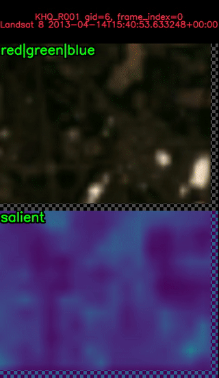
The first image illustrates the broad area search (BAS) component of the pipeline that uses low spatio-temporal resolution data to detect candidate “salient” regions for further processing.
The next main component of the system is activity characterization (AC) where higher resolution data is used to refine predicted information. In this case we classify each polygon as a different phase of construction. In the above example there are 3 detected candidates. We now zoom in on the one in the middle.
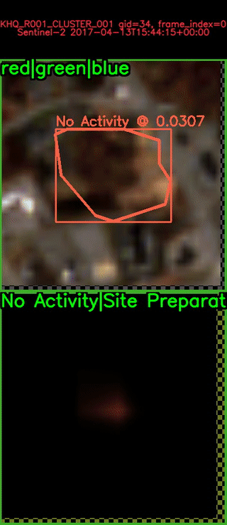
This shows the system detecting the construction of the KHQ building and classifying its phases. This demo was run on public data, and can be reproduced with Tutorial 6. The system was not trained on this region.
Publicly released model weights indexed via the decentralized IPFS protocol as well as through Kitware’s centralized Girder system. Note IPFS links use the ipfs.io gateway, but the CID can be used to accesss the data directly. See IPFS tutorials for details.
Publicly Released Model Weights |
||
|---|---|---|
Release Date |
IPFS |
Girder |
2024-01-11 |
System Requirements
Before you start you must have installed Python. We currently support CPython versions 3.10 and 3.11.
Getting Started
The geowatch package is available on pypi and can be installed with pip. To install a barebones version of geowatch with limited features and dependencies, run:
pip install geowatch[headless]Note that it is import to specify “headless”, to indicate that the opencv-python-headless variant of opencv that should be used. Alternatively, you could specify “graphics” to use the opencv-python variant, but we have found that this can cause conflicts with Qt libraries.
Alternatively, for a fully featured install of GeoWATCH run:
pip install geowatch[headless,optional,development,tests]After installing geowatch from from pypi, you will have access to the GeoWATCH command line interface (CLI). At this point you should be able to use the CLI to list available commands:
geowatch --helpUnfortunately, the install is not complete. This is because binary wheels for GDAL are not available on pypi, and this means we cannot access them at GeoWATCH install-time. Fortunately, Kitware hosts binary GDAL wheels, and GeoWATCH provides a tool to install them and complete its installation.
geowatch finish_installIf you use the fully featured install command (which can be run even if GeoWATCH is already installed), or have at least installed xdoctest, you can test that your install is functioning correctly by running the doctests in the geowatch module:
xdoctest -m geowatchThe GeoWATCH CLI has support for tab-complete, but this feature needs to be enabled.
For more details see the installing GeoWATCH for development guide.
We also have limited windows support, see installing GeoWATCH on Windows.
Tutorials
We have a set of tutorials related to training models and predicting with the system.
Tutorial 1: Toy RGB Fusion Model Example
Tutorial 2: Toy MSI Fusion Model Example
Tutorial 3: Feature Fusion Tutorial
Tutorial 4: Misc Training Tutorial
Tutorial 5: KR2 BAS SMART Demo
Tutorial 6: KHQ SMART Demo
Documentation
For quick reference, a list of current documentation files is:
Contribution:
Installing:
Fusion Related Docs:
Older Design Docs:
Development
For new collaborators, please refer to the onboarding docs
For internal collaborators, please refer to the internal docs
For more details about the GeoWATCH CLI and other CLI tools included in this package see: the GeoWATCH CLI docs
The geowatch module is built on top of several other supporting libraries developed by Kitware. Familiarity with these packages will make it easier to understand the GeoWATCH codebase. Particularly, developers should be have some familiarity with kwcoco, kwimage, scriptconfig, and ubelt. Also helpful is familiarity with ndsampler, delayed_image, cmd_queue, and xdoctest.
Published Research
IGARSS 2024: Slides, Conference Page, Paper (ArXiV), Paper (DeSci)
WACV 2024: Open Access Paper.
Acknowledgement
This research is based upon work supported in part by the Office of the Director of National Intelligence (ODNI), 6 Intelligence Advanced Research Projects Activity (IARPA), via 2021-2011000005. The views and conclusions contained herein are those of the authors and should not be interpreted as necessarily representing the official policies, either expressed or implied, of ODNI, IARPA, or the U.S. Government. The U.S. Government is authorized to reproduce and distribute reprints for governmental purposes notwithstanding any copyright annotation therein
Release history Release notifications | RSS feed


Download files
Download the file for your platform. If you're not sure which to choose, learn more about installing packages.
Source Distribution
Built Distribution
Filter files by name, interpreter, ABI, and platform.
If you're not sure about the file name format, learn more about wheel file names.
Copy a direct link to the current filters
File details
Details for the file geowatch-0.20.0.tar.gz.
File metadata
- Download URL: geowatch-0.20.0.tar.gz
- Upload date:
- Size: 2.5 MB
- Tags: Source
- Uploaded using Trusted Publishing? No
- Uploaded via: twine/6.1.0 CPython/3.13.5
File hashes
| Algorithm | Hash digest | |
|---|---|---|
| SHA256 |
27754e244a84c03d8ab7331725d107f93695d804e13b64c92bfdf813190c44f5
|
|
| MD5 |
602bf3c13f4d1cde805f186425bf02fb
|
|
| BLAKE2b-256 |
aeafd585911b2161a9d7345d6d05d9c1221c98202f98e0a77f02f19edb459a77
|
File details
Details for the file geowatch-0.20.0-py3-none-any.whl.
File metadata
- Download URL: geowatch-0.20.0-py3-none-any.whl
- Upload date:
- Size: 2.8 MB
- Tags: Python 3
- Uploaded using Trusted Publishing? No
- Uploaded via: twine/6.1.0 CPython/3.13.5
File hashes
| Algorithm | Hash digest | |
|---|---|---|
| SHA256 |
b1c580a69e2966610b1b9c6ff9647800a17fa8898ef4c3737e48097a7630c381
|
|
| MD5 |
54ae8b38d7a47a8864739cfd9c4323cd
|
|
| BLAKE2b-256 |
76f86d168691ff027ee815bdc03c9cf2cfba9ad1d8292a798720b69f4f933421
|


