A Python package to process raw GPS data of public transit and transform to GTFS format.

Project description
gps2gtfs: A Python package to process raw GPS data of public transit and transform to GTFS format


-
Project Lead(s) / Mentor(s)
- Dr. T. Uthayasanker
-
Contributor(s)
- R. Shiveswarran
- S. Gopinath
- S. Kajanan
- A. Kesavi
Description
Keywords: GTFS, GPS, Travel Time, Public Transit, Heterogeneous Traffic Condition, ITS (Intelligent Transportation System)
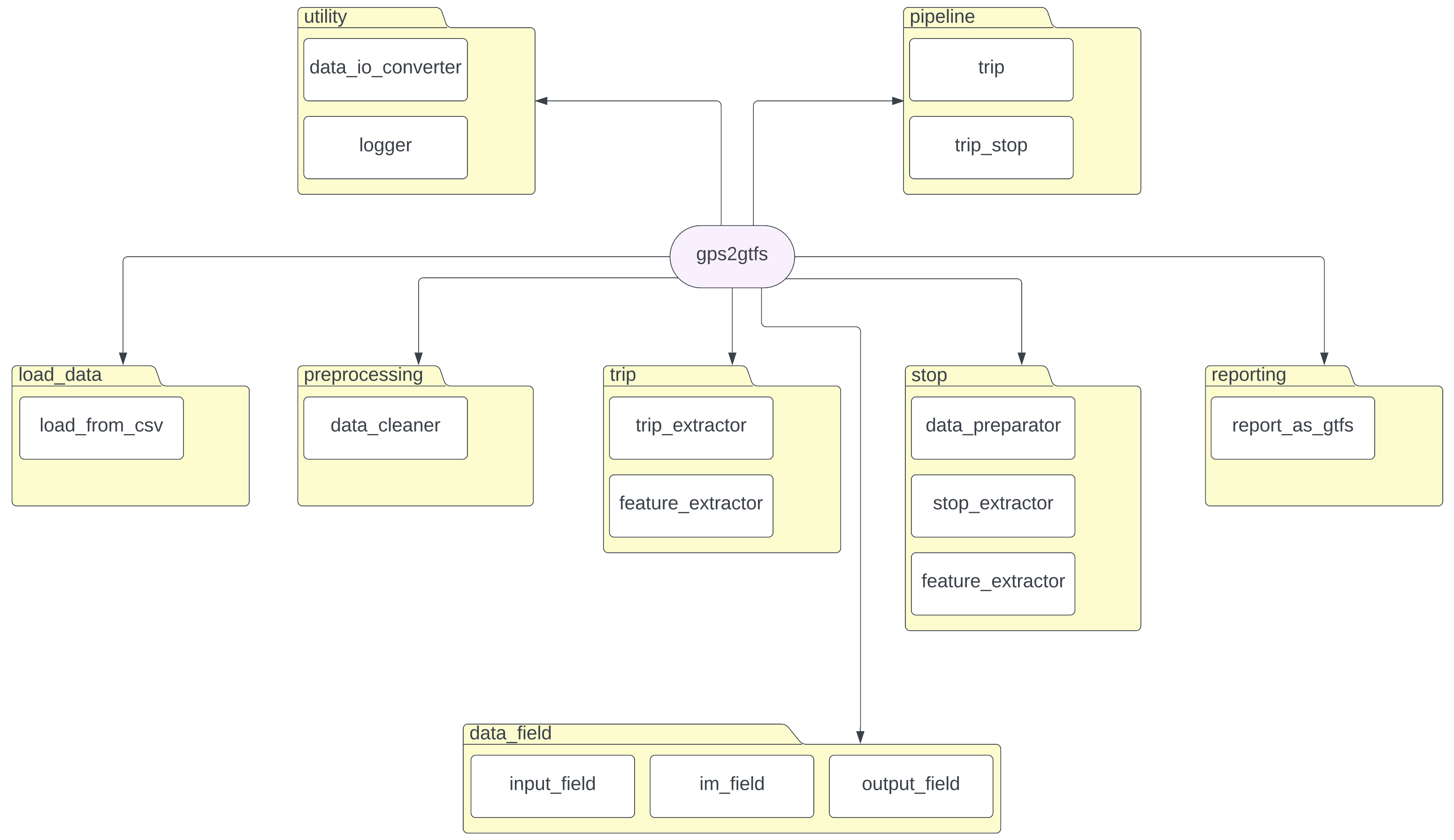
Architecture
The package is structured into eight(8) primary packages:
- data_field: This package is responsible for managing column names for user input and a predefined set of output columns. The fields provided by the user should be a superset of the defined fields within this package.
- load_data: This package handles the loading of necessary data into the pipeline.
- preprocessing: The preprocessing package is designed to clean the data loaded from the previous step.
- trip: The trip package focuses on extracting trips and generating associated features.
- stop: Within the stop package, the identification of stops and the creation of related features take place.
- reporting: This package is responsible for generating outputs containing the extracted information.
- pipeline: This package contains functionality to execute the trip extraction pipeline and the trip & stop extraction pipeline.
- utility: The utility module provides support for various utility functions, including input/output operations, data conversions, and logging.
Architecture digram of gps2gfts
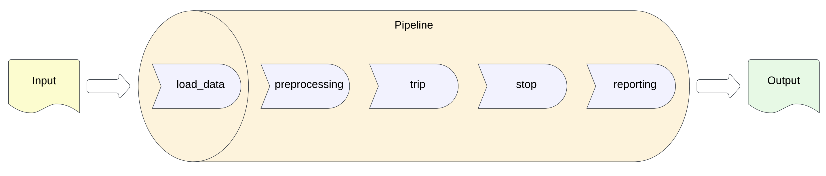
How the gps2gfts works
Quick Example
It is essential to provide input files in CSV format for proper functionality. Additionally, the utilization of this package requires the presence of a main thread.
1. Pipeline to extract trips details
from gps2gtfs.pipeline.trip import run


if __name__ == "__main__":
    raw_gps_data_path = "path/to/raw_gps_data/csv"
    trip_terminals_data_path = "path/to/trip_terminals_data/csv"
    terminals_buffer_radius = 100

    run(
        raw_gps_data_path,
        trip_terminals_data_path,
        terminals_buffer_radius,
    )
2. Pipeline to extract trips and stops details
from gps2gtfs.pipeline.trip_stop import run


if __name__ == "__main__":
    raw_gps_data_path = "path/to/raw_gps_data/csv"
    trip_terminals_data_path = "path/to/trip_terminals_data/csv"
    stops_data_path = "path/to/stops_data/csv"
    terminals_buffer_radius = 100
    stops_buffer_radius = 50
    stops_extended_buffer_radius = 100

    run(
        raw_gps_data_path,
        trip_terminals_data_path,
        stops_data_path,
        terminals_buffer_radius,
        stops_buffer_radius,
        stops_extended_buffer_radius,
    )
License
MIT License. You can see here.
Code of Conduct
Please read our code of conduct document here.
Release history Release notifications | RSS feed

Download files
Download the file for your platform. If you're not sure which to choose, learn more about installing packages.
Source Distributions
Built Distribution
Filter files by name, interpreter, ABI, and platform.
If you're not sure about the file name format, learn more about wheel file names.
Copy a direct link to the current filters
File details
Details for the file gps2gtfs-0.1.0-py3-none-any.whl.
File metadata
- Download URL: gps2gtfs-0.1.0-py3-none-any.whl
- Upload date:
- Size: 22.7 kB
- Tags: Python 3
- Uploaded using Trusted Publishing? No
- Uploaded via: twine/4.0.2 CPython/3.9.13
File hashes
| Algorithm | Hash digest | |
|---|---|---|
| SHA256 |
997d4c80812f57e52e74373ec5b1d190e4de53d731228fd1e2079f746b679744
|
|
| MD5 |
9354a4977e73882df3cd0dcfdd9b088c
|
|
| BLAKE2b-256 |
3de0b63f58e2cb8eed0b61ea4fbab922abd7816f45f894cc839f9f7df0dde64c
|


