
gridwxcomp
A package for comparing climate station time series data to gridMET (or other gridded) data. Major functionality includes tools to:
pair station locations with overlapping grid cells
download gridMET data from OpenDap server
calculate mean bias ratios between station and gridded data and other statistics
spatial interpolation of bias ratios with multiple interpolation options
build geo-referenced files of point data and interpolated rasters
extract zonal means for a subset of gridcells
graphics, e.g. time series comparisons and interpolated residuals at stations
Bias ratios calculated by gridwxcomp can be used to correct bias of grid to station data based on the properties of the stations. For example, monthly humidity ratios between station and grid for stations within agricultural settings can be used to estimate grid bias relative to agricultural locations. gridwxcomp includes an intuitive command line interface and a Python API.
Documentation
Installation
Currently we recommend using the provided conda environment file to install gridwxcomp and its dependencies in a virtual environment. Download the environment.yml file and then install and activate it. If you don’t have conda get it here. To install dependencies in a virtual environment run
$ conda env create -f environment.ymlTo activate the environment before using gridwxcomp run
$ conda activate gridwxcompOptionally, install using pip,
$ pip install gridwxcompDue to dependency conflicts you may have issues directly installing with pip before activating the conda environment.
Alternatively, or if there are installation issues, you can manually install. First activate the gridwxcomp conda environment (above). Next, clone or download the package from GitHub or PyPI and then install locally with pip in “editable” mode. For example with cloning,
$ git clone https://github.com/WSWUP/gridwxcomp.git
$ cd gridwxcomp
$ pip install -e .
If you downloaded the source distribution then run pip install -e . in the root directory where the setup.py file is located. This installation method is ideal if you want to be able to modify the source code.
Quick start from command line
This example uses data provided with gridwxcomp including climate variable time series data for four climate stations, it uses the gridMET as the gridded dataset however any uniform gridded data product can be used with gridwxcomp if extra information including a vector grid file is provided.
After installation you can find the location of the data needed for the example by typing the following at the command line,
$ python -c "import pkg_resources; print(pkg_resources.resource_filename('gridwxcomp', 'example_data/Station_Data.txt'))"Once complete, this example will calculate bias ratios between station and gridMET ETr (reference evapotranspiration), spatially interpolate GeoTIFF rasters of bias ratios at 400 meter resolution, and calculate zonal statistics of mean bias ratios for each gridMET cell in the region of the stations, similar to what is shown in the figure below.
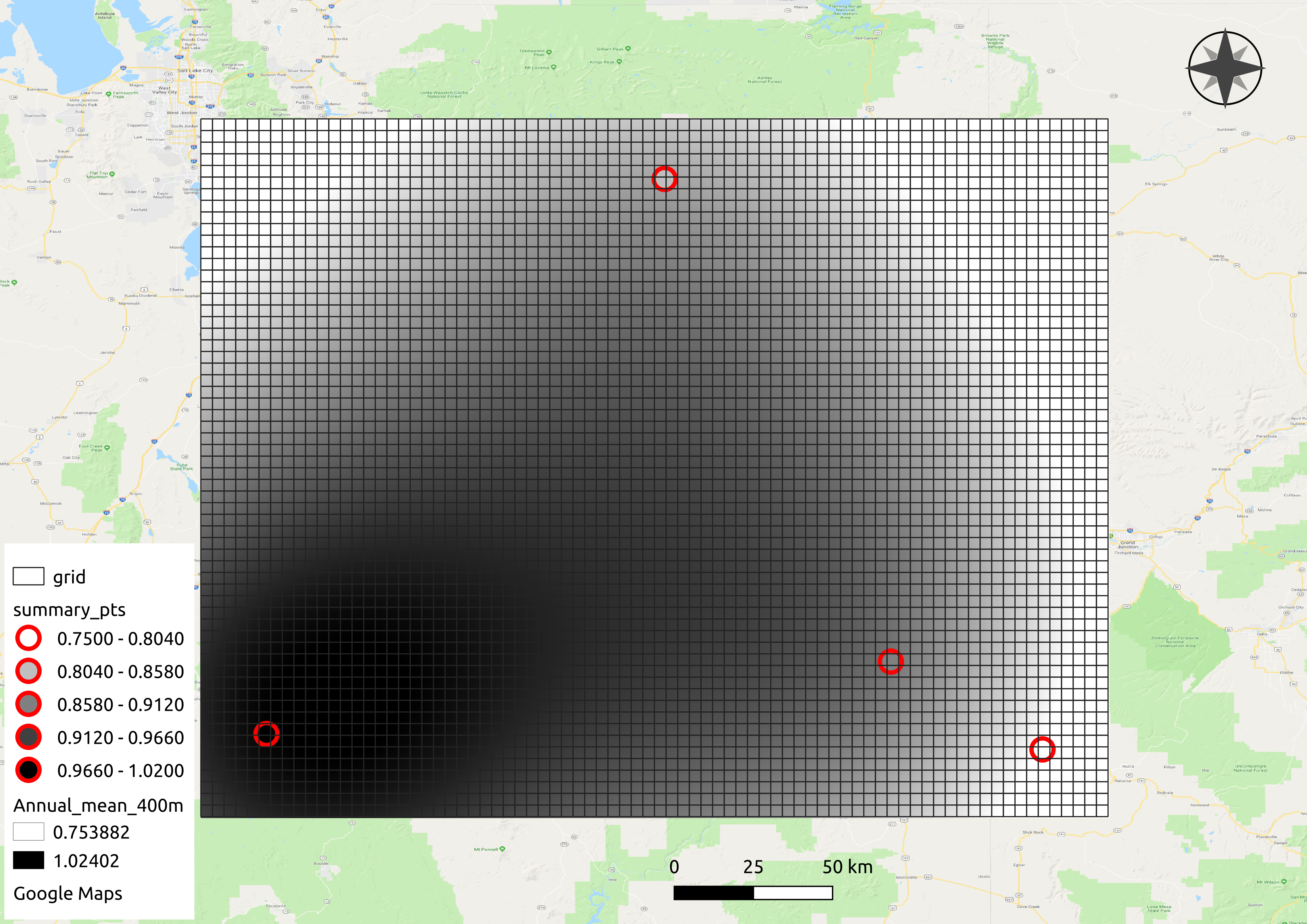
The same procedure can be done for climate variables other than ETr, e.g. observed evapotranspiration, temperature, precipitation, wind speed, short wave radiation, etc.
After installing with pip the gridwxcomp command line interface can be used from any directory, the first step pairs climate station data with their nearest gridMET cell and produces a CSV file used in the following steps,
$ gridwxcomp prep-input <PATH_TO example_data/Station_Data.txt>This will result in the file “merged_input.csv”. Next download matching gridMET climate time series with OpeNDAP by running
$ gridwxcomp download-gridmet-opendap merged_input.csv -y 2016-2017The time series of gridMET data that correpond with the stations in “merged_input.csv” will be saved to a new folder called “gridmet_data” by default. In this case only the years 2016-2017 are used.
Next, to calculate mean monthly and annual bias ratios for each station/gridMET pair along with other statistics and metadata and save to CSV files,
$ gridwxcomp calc-bias-ratios merged_input.csv -o monthly_ratiosLast, to calculate interpolated surfaces of mean bias ratios and extract zonal means to gridMET cells using the default interpolation method (inverse distance weighting):
$ gridwxcomp spatial monthly_ratios/etr_mm_summary_comp_all_yrs.csv -b 5The [-b 5] option indicates that we want to expand the rectangular bounding area for interpolation by five gridMET cells (extrapolation in the outer regions).
GeoTIFF rasters of interpolated ratios will be saved to “monthly_ratios/spatial/etr_mm_invdist_400m/”. Note, the gridMET variable name (etr_mm), the interpolation method (invdist), and the raster resolution (400m) are specified in the output directory. A fishnet grid with gridMET id values and a point shapefile of station ratios should all be created and saved in the “monthly_ratios/spatial/” directory.
The output file “monthly_ratios/spatial/etr_mm_invdist_400m/gridMET_stats.csv” contains monthly bias ratios for each gridMET cell in the interpolation region, similar to what is shown below.
GRIDMET_ID
Jan_mean
Feb_mean
Mar_mean
…
515902
0.66
0.76
0.96
…
514516
0.66
0.77
0.96
…
513130
0.67
0.77
0.97
…
511744
0.67
0.78
0.97
…
510358
0.68
0.79
0.97
…
…
…
…
…
…
Note GRIDMET_ID is the index of the master gridMET dataset 4 km fishnet grid starting at 0 in the upper left corner and moving across rows and down columns. This value can be joined with previously created data, e.g. the ID values can be joined to centroid coordinates of gridMET cells.
Bar plots that show the residual between station mean ratios and interpolated estimates are saved to “monthly_ratios/spatial/etr_mm_invdist_400m/residual_plots/”.
To get abbreviated descriptions for any of the above gridwxcomp commands use the [--help] option, e.g.
$ gridwxcomp spatial --help1 maintainer

Metadata
1 maintainer
Release files for gridwxcomp 0.1.0
For a detailed explanation of source distributions (sdists) and built distributions (wheels), please see the package formats documentation.
Source distribution (sdist)
| File | Size | Uploaded | Provenance | Actions |
|---|---|---|---|---|
| gridwxcomp-0.1.0.tar.gz | 1.6 MB | Without provenance | Details for gridwxcomp-0.1.0.tar.gz |
Built distribution (wheel)
| File | Interpreter | ABI | Platform | Actions Reset |
|---|---|---|---|---|
| gridwxcomp-0.1.0-py2.py3-none-any.whl | Python 2, Python 3 | none | any | Details for gridwxcomp-0.1.0-py2.py3-none-any.whl |
Total release size: 13.7 MB
Release files / gridwxcomp-0.1.0.tar.gz
| Download URL | gridwxcomp-0.1.0.tar.gz |
|---|---|
| Size | 1.6 MB |
| Tags | Source |
|
SHA-256 checksum How to use checksums |
64887f10f8b0717bb596fcb9ae2d212a830b5d512cd08b1767f84207e09e5453
|
|
BLAKE2b-256 checksum How to use checksums |
6fae7652a6011c4e54e53cf2e3be96bdea19c4746a0b570753b0b35693bce66f
|
| Upload date | |
|
Uploaded using Trusted Publishing? What is trusted publishing? |
No |
| Uploaded via |
twine/1.11.0 pkginfo/1.4.2 requests/2.19.1 setuptools/40.1.0 requests-toolbelt/0.8.0 tqdm/4.24.0 CPython/3.6.8
|
Release files / gridwxcomp-0.1.0-py2.py3-none-any.whl
| Download URL | gridwxcomp-0.1.0-py2.py3-none-any.whl |
|---|---|
| Size | 12.2 MB |
| Tags | Python 2 Python 3 |
|
SHA-256 checksum How to use checksums |
cec8f411f7d599df808bcb19731137bfd997ba235d2140d52d6be16016d68af5
|
|
BLAKE2b-256 checksum How to use checksums |
d4f224ce80a23216bd4cec4b8d507c3e110ef94810199a0abc5f16e59dad9853
|
| Upload date | |
|
Uploaded using Trusted Publishing? What is trusted publishing? |
No |
| Uploaded via |
twine/1.11.0 pkginfo/1.4.2 requests/2.19.1 setuptools/40.1.0 requests-toolbelt/0.8.0 tqdm/4.24.0 CPython/3.6.8
|
Security for gridwxcomp 0.1.0
Provenance
Provenance describes where a file came from. On PyPI, provenance is shared via attestations, which provide a verifiable record of the build or publishing details. View details, limitations and caveats.
No provenance found
None of the files in this release were uploaded with provenance metadata.
A note on package security
PyPI is a repository for distributing packages, not a service for auditing them. While third-party security researchers and our staff do their best to detect and remove malicious packages, PyPI cannot guarantee the quality, security or suitability of any given package.
To learn more about protecting yourself from malicious actors, visit our package security documentation.














