Hydro Engine is a small service and a command-line tool built on top of [Google Earth Engine](http://earthengine.google.com) that allows querying various hydrological variables, useful as an input for hydrological models.
[](https://travis-ci.org/openearth/hydro-engine)
The command-line Python tool can be installed using the following commands: ` > pip install hydroengine `
Once the package is installed, you can use `hydroengine` command to download input data needed for your hydrological model.
Upstream catchments, rivers and various raster variables can be queried using following commands:
` > hydroengine region.json --get-catchments catchments.json > hydroengine region.json --get-rivers rivers.json > hydroengine region.json --get-raster dem dem.tif 1000 EPSG:4326 > hydroengine region.json --get-lakes lakes.json > hydroengine region.json --get-lake-variable 183160 water_area area.json `
See [examples/run.sh](https://github.com/Deltares/hydro-engine/blob/master/examples/run.sh), showing how different data types can be downloaded.
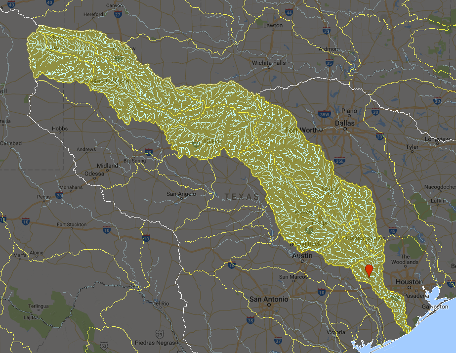
All data types can be queried for an input area or location (GeoJSON polygon geometry). A polygon may define a flood location. For example, in the figure below, a single point near Houston is used to query upstream catchments and a drainage network, providing runoff water for that location.
<img src=”https://github.com/Deltares/hydro-engine/blob/master/docs/example_query.png?raw=true” alt=”Example” width=”626” height=”485”>
Supported functionality:
Querying upstream catchments as a single or multiple polygons. Source: [HydroBASINS](http://www.hydrosheds.org/page/hydrobasins)
Querying upstream drainage network as polylines. Source: [HydroSHEDS](http://hydrosheds.org)
- Querying raster variables:
dem [m] - in meters, source: 30m SRTM v4
hand [m] - Height Above the Nearest Drainage ([HAND](http://global-hand.appspot.com))
FirstZoneCapacity [-] - ?
FirstZoneKsatVer [-] - ?
FirstZoneMinCapacity [-] - ?
InfiltCapSoil [-] - ?
M [-] - ?
PathFrac [-] - ?
WaterFrac [-] - ?
thetaS [-] - ?
soil_type [-] - soil type, based on ?
landuse [-] - land use type, based on MODIS 500m
LAI01…LAI12 - leaf area index monthly climatology, source: [eartH2Observe](http://www.earth2observe.eu/)
History
0.1.0 (2018-08-27)
First release on PyPI.
1 maintainer

Metadata
1 maintainer
Release files for hydroengine 0.0.30
For a detailed explanation of source distributions (sdists) and built distributions (wheels), please see the package formats documentation.
Source distribution (sdist)
| File | Size | Uploaded | |
|---|---|---|---|
| hydroengine-0.0.30.tar.gz | 370.1 kB | Details |
Built distribution (wheel)
| File | Interpreter | ABI | Platform | Reset |
|---|---|---|---|---|
| hydroengine-0.0.30-py2.py3-none-any.whl | Python 3, Python 2 | none | any | Details |
Total release size: 376.2 kB
Release files / hydroengine-0.0.30.tar.gz
| Download URL | hydroengine-0.0.30.tar.gz |
|---|---|
| Size | 370.1 kB |
| Tags | Source |
|
SHA-256 checksum How to use checksums |
7711fccea6bb4a8b7ecf0085a62e3400f8820a98fa61359065b701c6abfcc524
|
|
BLAKE2b-256 checksum How to use checksums |
cdd6f10efea5e2c547e7c924bd6d4b794f95855ebf1bb0dba1c34b6fa4a34a6a
|
| Upload date | |
|
Uploaded using Trusted Publishing? What is trusted publishing? |
No |
| Uploaded via |
twine/1.10.0 pkginfo/1.4.2 requests/2.19.1 setuptools/40.4.3 requests-toolbelt/0.8.0 tqdm/4.26.0 CPython/2.7.6
|
Release files / hydroengine-0.0.30-py2.py3-none-any.whl
| Download URL | hydroengine-0.0.30-py2.py3-none-any.whl |
|---|---|
| Size | 6.1 kB |
| Tags | Python 2 Python 3 |
|
SHA-256 checksum How to use checksums |
42531f6eb7526a8ef97a8b78c7766ec0fcbbbc9bb996f63a75116b9a465446bb
|
|
BLAKE2b-256 checksum How to use checksums |
ed986a5e1eb225296e36d55a388faca897fe90b32f5f436ca81374dd866f6b72
|
| Upload date | |
|
Uploaded using Trusted Publishing? What is trusted publishing? |
No |
| Uploaded via |
twine/1.10.0 pkginfo/1.4.2 requests/2.19.1 setuptools/40.4.3 requests-toolbelt/0.8.0 tqdm/4.26.0 CPython/2.7.6
|















](https://travis-ci.org/openearth/hydro-engine)