A rio-tiler plugin to create tile for arbitraty grid


Project description
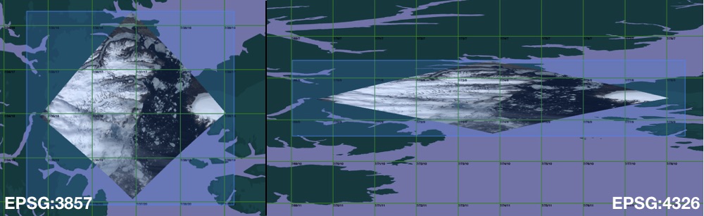
rio-tiler-crs
A rio-tiler plugin to create tiles in different projection


Install
$ pip install pip -U
$ pip install rio-tiler-crs

# Or using source

$ pip install git+http://github.com/cogeotiff/rio-tiler-crs
How To
rio-tiler-crs uses morecantile to define the custom tiling grid schema.
- Define grid system
import morecantile
from rasterio.crs import CRS

# Use default TMS
tms = morecantile.tms.get("WorldCRS84Quad")

# or create a custom TMS
crs = CRS.from_epsg(3031)  # Morecantile TileMatrixSet uses Rasterio CRS object
extent = [-948.75, -543592.47, 5817.41, -3333128.95]  # From https:///epsg.io/3031
tms = morecantile.TileMatrixSet.custom(extent, crs)
- read tile
from rio_tiler_crs import tiler

# Read tile x=10, y=10, z=4
tile, mask = tiler.tile("myfile.tif", 10, 10, 4, tms=tms)
API
- rio_tiler_crs.tiler.get_zoom: Get Min/Max zoom for a specific Raster in a specific TMS system
tms = morecantile.tms.get("WorldCRS84Quad")
with rasterio.open("myfile.tif") as src_dst:
    minzoom, maxzoom = tiler.get_zoom(src_dst, tms)
- rio_tiler_crs.tiler.spatial_info: Return Raster spatial info for a specific TMS system
tms = morecantile.tms.get("WorldCRS84Quad")
tiler.spatial_info("myfile.tif", tms)
{
    "address": "myfile.tif",
    "bounds": List[float],  # raster bounds in tms's CRS
    "center": Tuple[float, float, int],  # raster center in tms's CRS
    "minzoom": int,  # raster minzoom in tms
    "maxzoom": int,  # raster maxzoom in tms

}
- rio_tiler_crs.tiler.bounds: Return Raster bounds for a specific CRS
dst_crs = CRS.from_epsg(3031)
tiler.bounds("myfile.tif", dst_crs)

{
    "address": "myfile.tif",
    "bounds": List[float],  # raster bounds in dst_crs
}
-
rio_tiler_crs.tiler.metadata: same as rio_tiler.io.cogeo.metadata
-
rio_tiler_crs.tiler.info: Return simple metadata about the raster
tms = morecantile.tms.get("WorldCRS84Quad")
tiler.info("myfile.tif", tms)

{
    "address": "myfile.tif",
    "bounds": List[float],  # raster bounds in tms's CRS
    "center": Tuple[float, float, int],  # raster center in tms's CRS
    "minzoom": int,  # raster minzoom in tms
    "maxzoom": int,  # raster maxzoom in tms
    "band_metadata": List[Tulple[int, Dict]],  # List of band tags
    "band_descriptions": List[str],  # List of band names
    "dtype": str,  # raster datatype
    "colorinterp": List[str],  # List of band colorinterpretation values
    "nodata_type": str,  # raster io nodata type
    "scale": float,  # raster scaling factor
    "offset": float,  # raster offset factor
    "cmap":  Dict,  # raster internal colormap
}
- rio_tiler_crs.tiler.tile: Return map tile from a raster
tms = morecantile.tms.get("WorldCRS84Quad")
tile, mask = tiler.tile("myfile.tif", 1, 2, 3, 256, tms)
Example
See /demo
Contribution & Development
Issues and pull requests are more than welcome.
dev install
$ git clone https://github.com/cogeotiff/rio-tiler-crs.git
$ cd rio-tiler-crs
$ pip install -e .[dev]
Python >=3.7 only
This repo is set to use pre-commit to run isort, flake8, pydocstring, black ("uncompromising Python code formatter") and mypy when committing new code.
$ pre-commit install

$ git add .

$ git commit -m'my change'
isort....................................................................Passed
black....................................................................Passed
Flake8...................................................................Passed
Verifying PEP257 Compliance..............................................Passed
mypy.....................................................................Passed

$ git push origin
Release history Release notifications | RSS feed


Download files
Download the file for your platform. If you're not sure which to choose, learn more about installing packages.
Source Distribution
rio-tiler-crs-1.0.2.tar.gz
(5.2 kB
view details)
File details
Details for the file rio-tiler-crs-1.0.2.tar.gz.
File metadata
- Download URL: rio-tiler-crs-1.0.2.tar.gz
- Upload date:
- Size: 5.2 kB
- Tags: Source
- Uploaded using Trusted Publishing? No
- Uploaded via: twine/3.1.1 pkginfo/1.5.0.1 requests/2.23.0 setuptools/40.8.0 requests-toolbelt/0.9.1 tqdm/4.46.0 CPython/3.7.2
File hashes
| Algorithm | Hash digest | |
|---|---|---|
| SHA256 |
7ac4349449064a2c16682ebae490f7814d843df7d0725e59bcc0bef870e82580
|
|
| MD5 |
06aa9c13e4c8895a9752540b28a596e9
|
|
| BLAKE2b-256 |
f635524f0d32ebd583c35a49a7d395eee7dd6330d9d8b2144fb9fbad0262dddb
|


