User friendly Rasterio plugin to read raster datasets.
Verified details
These details have been verified by PyPIProject links
GitHub Statistics
Maintainers


Project description
rio-tiler
User friendly Rasterio plugin to read raster datasets.


Documentation: https://cogeotiff.github.io/rio-tiler/
Source Code: https://github.com/cogeotiff/rio-tiler
Description
rio-tiler was initially designed to create slippy map
tiles from large raster data
sources and render these tiles dynamically on a web map. Since rio-tiler v2.0, we added many more helper methods to read
data and metadata from any raster source supported by Rasterio/GDAL.
This includes local and remote files via HTTP, AWS S3, Google Cloud Storage,
etc.
At the low level, rio-tiler is just a wrapper around the rasterio and GDAL libraries.
Features
-
Read any dataset supported by GDAL/Rasterio
from rio_tiler.io import Reader

with Reader("my.tif") as image:
    print(image.dataset)  # rasterio opened dataset
    img = image.read()    # similar to rasterio.open("my.tif").read() but returns a rio_tiler.models.ImageData object
-
User friendly
tile,part,feature,pointreading methodsfrom rio_tiler.io import Reader with Reader("my.tif") as image: img = image.tile(x, y, z) # read mercator tile z-x-y img = image.part(bbox) # read the data intersecting a bounding box img = image.feature(geojson_feature) # read the data intersecting a geojson feature img = image.point(lon,lat) # get pixel values for a lon/lat coordinates
-
Enable property assignment (e.g nodata) on data reading
from rio_tiler.io import Reader

with Reader("my.tif") as image:
    img = image.tile(x, y, z, nodata=-9999) # read mercator tile z-x-y
-
STAC support
from rio_tiler.io import STACReader

with STACReader("item.json") as stac:
    print(stac.assets)  # available asset
    img = stac.tile(  # read tile for asset1 and indexes 1,2,3
        x,
        y,
        z,
        assets="asset1",
        indexes=(1, 2, 3),  # same as asset_indexes={"asset1": (1, 2, 3)},
    )

    # Merging data from different assets
    img = stac.tile(  # create an image from assets 1,2,3 using their first band
        x,
        y,
        z,
        assets=("asset1", "asset2", "asset3",),
        asset_indexes={"asset1": 1, "asset2": 1, "asset3": 1},
    )
-
Xarray support (>=4.0)
import xarray
from rio_tiler.io import XarrayReader

ds = xarray.open_dataset(
    "https://pangeo.blob.core.windows.net/pangeo-public/daymet-rio-tiler/na-wgs84.zarr/",
    engine="zarr",
    decode_coords="all",
    consolidated=True,
)
da = ds["tmax"]
with XarrayReader(da) as dst:
    print(dst.info())
    img = dst.tile(1, 1, 2)
Note: The XarrayReader needs optional dependencies to be installed
pip install rio-tiler["xarray"]. -
Non-Geo Image support (>=4.0)
from rio_tiler.io import ImageReader

with ImageReader("image.jpeg") as src:
    im = src.tile(0, 0, src.maxzoom)  # read top-left `tile`
    im = src.part((0, 100, 100, 0))  # read top-left 100x100 pixels
    pt = src.point(0, 0)  # read pixel value
Note:
ImageReaderis also compatible with proper geo-referenced raster datasets. -
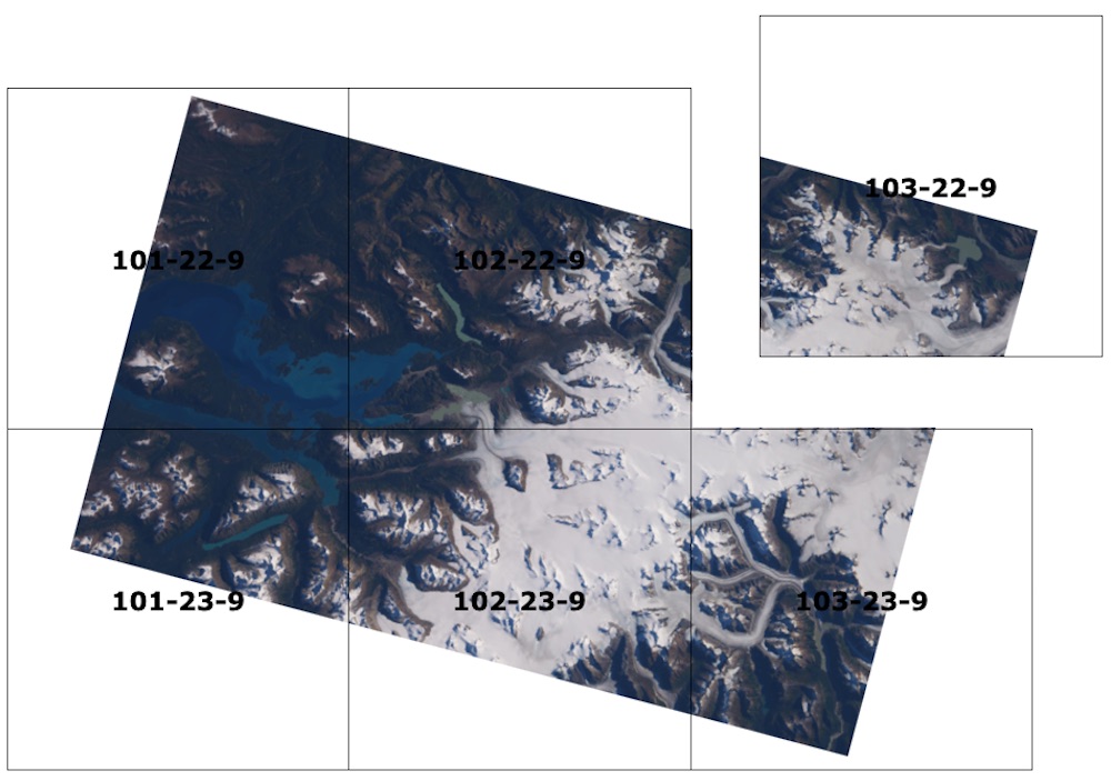
Mosaic (merging or stacking)
from rio_tiler.io import Reader
from rio_tiler.mosaic import mosaic_reader

def reader(file, x, y, z, **kwargs):
    with Reader(file) as image:
        return image.tile(x, y, z, **kwargs)

img, assets = mosaic_reader(["image1.tif", "image2.tif"], reader, x, y, z)
-
Native support for multiple TileMatrixSet via morecantile
import morecantile
from rio_tiler.io import Reader

# Use EPSG:4326 (WGS84) grid
wgs84_grid = morecantile.tms.get("WorldCRS84Quad")
with Reader("my.tif", tms=wgs84_grid) as src:
    img = src.tile(1, 1, 1)
Install
You can install rio-tiler using pip
python -m pip install -U pip
python -m pip install -U rio-tiler
or install from source:
git clone https://github.com/cogeotiff/rio-tiler.git
cd rio-tiler
python -m pip install -U pip
python -m pip install -e .
Plugins
rio-tiler-pds
rio-tiler v1 included several helpers for reading popular public datasets (e.g. Sentinel 2, Sentinel 1, Landsat 8, CBERS) from cloud providers. This functionality is now in a separate plugin, enabling easier access to more public datasets.
rio-tiler-mvt
Create Mapbox Vector Tiles from raster sources
Implementations
titiler: A lightweight Cloud Optimized GeoTIFF dynamic tile server.
cogeo-mosaic: Create mosaics of Cloud Optimized GeoTIFF based on the mosaicJSON specification.
Contribution & Development
See CONTRIBUTING.md
Authors
The rio-tiler project was begun at Mapbox and was transferred to the cogeotiff Github organization in January 2019.
See AUTHORS.txt for a listing of individual contributors.
Changes
See CHANGES.md.
License
See LICENSE
Project details
Verified details
These details have been verified by PyPIProject links
GitHub Statistics
Maintainers
Release history Release notifications | RSS feed


Download files
Download the file for your platform. If you're not sure which to choose, learn more about installing packages.
Source Distribution
Built Distribution
Filter files by name, interpreter, ABI, and platform.
If you're not sure about the file name format, learn more about wheel file names.
Copy a direct link to the current filters
File details
Details for the file rio_tiler-9.4.0.tar.gz.
File metadata
- Download URL: rio_tiler-9.4.0.tar.gz
- Upload date:
- Size: 212.2 kB
- Tags: Source
- Uploaded using Trusted Publishing? Yes
- Uploaded via: twine/6.1.0 CPython/3.13.13
File hashes
| Algorithm | Hash digest | |
|---|---|---|
| SHA256 |
e9872746181097ff2eac68270069459f98d93e82390419d14798ece135759ed1
|
|
| MD5 |
30c54d87ca7c0e72afe12dc51a5c056a
|
|
| BLAKE2b-256 |
9de9f5c6516866f18a1fcad23cef8bbf29d9006d14714b2c8c8dac758c6a4c73
|
Provenance
The following attestation bundles were made for rio_tiler-9.4.0.tar.gz:
Publisher:
release.yml on cogeotiff/rio-tiler
-
Statement:
-
Statement type:
https://in-toto.io/Statement/v1 -
Predicate type:
https://docs.pypi.org/attestations/publish/v1 -
Subject name:
rio_tiler-9.4.0.tar.gz -
Subject digest:
e9872746181097ff2eac68270069459f98d93e82390419d14798ece135759ed1 - Sigstore transparency entry: 2047883975
- Sigstore integration time:
-
Permalink:
cogeotiff/rio-tiler@c4b4d377c01fd28fc692635748bfe82bcf47dd90 -
Branch / Tag:
refs/tags/9.4.0 - Owner: https://github.com/cogeotiff
-
Access:
public
-
Token Issuer:
https://token.actions.githubusercontent.com -
Runner Environment:
github-hosted -
Publication workflow:
release.yml@c4b4d377c01fd28fc692635748bfe82bcf47dd90 -
Trigger Event:
push
-
Statement type:
File details
Details for the file rio_tiler-9.4.0-py3-none-any.whl.
File metadata
- Download URL: rio_tiler-9.4.0-py3-none-any.whl
- Upload date:
- Size: 316.0 kB
- Tags: Python 3
- Uploaded using Trusted Publishing? Yes
- Uploaded via: twine/6.1.0 CPython/3.13.13
File hashes
| Algorithm | Hash digest | |
|---|---|---|
| SHA256 |
fd73107b21d3fd7b93214b69eb67ba1359653388e5ff54c7a848281b3a886a1a
|
|
| MD5 |
5fcd0b5a9518754272547823c6773dae
|
|
| BLAKE2b-256 |
06e99fda5bfb9c6cb198a8187740cd4575c6871b966f02cda696a3c43bfa3986
|
Provenance
The following attestation bundles were made for rio_tiler-9.4.0-py3-none-any.whl:
Publisher:
release.yml on cogeotiff/rio-tiler
-
Statement:
-
Statement type:
https://in-toto.io/Statement/v1 -
Predicate type:
https://docs.pypi.org/attestations/publish/v1 -
Subject name:
rio_tiler-9.4.0-py3-none-any.whl -
Subject digest:
fd73107b21d3fd7b93214b69eb67ba1359653388e5ff54c7a848281b3a886a1a - Sigstore transparency entry: 2047883992
- Sigstore integration time:
-
Permalink:
cogeotiff/rio-tiler@c4b4d377c01fd28fc692635748bfe82bcf47dd90 -
Branch / Tag:
refs/tags/9.4.0 - Owner: https://github.com/cogeotiff
-
Access:
public
-
Token Issuer:
https://token.actions.githubusercontent.com -
Runner Environment:
github-hosted -
Publication workflow:
release.yml@c4b4d377c01fd28fc692635748bfe82bcf47dd90 -
Trigger Event:
push
-
Statement type:


