Spatial data processing for geomodeling


Project description

Spatial data and information processing for geomodeling and subsurface data


Overview
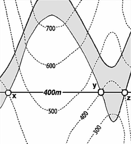
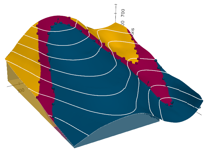
We attempt to simplify the access to open-source spatial data processing for geological modeling and for subsurface data (wells, seismic, etc.) with the development of GemGIS, a Python-based open-source library.
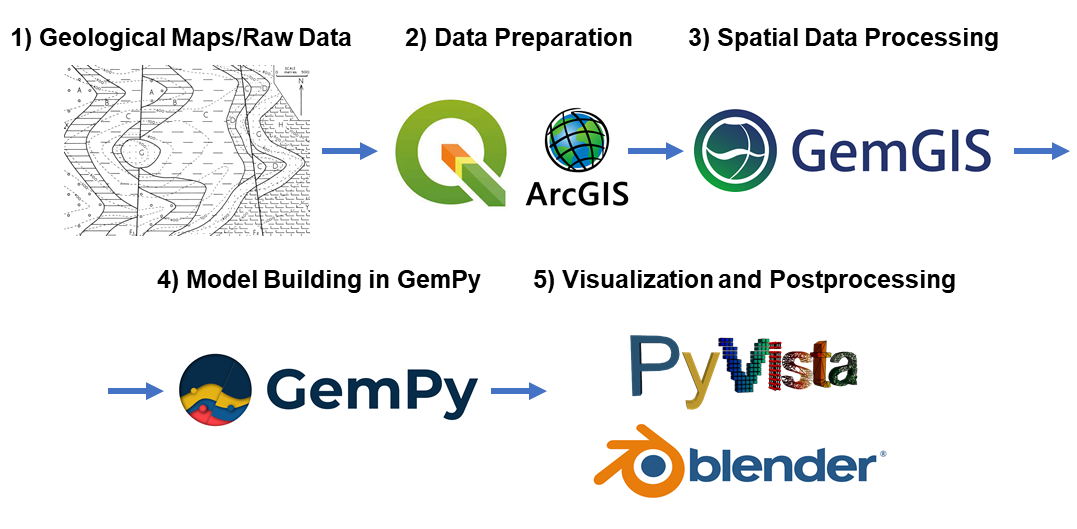
GemGIS wraps and extends the functionality of packages known to the geo-community such as GeoPandas, rasterio, OWSLib, Shapely, PyVista, Pandas, NumPy and the geomodeling package GemPy.
The aim of GemGIS, as indicated by the name, is to become a bridge between conventional geoinformation systems (GIS) such as ArcGIS and QGIS, and geomodeling tools such as GemPy, allowing simpler and more automated workflows from one environment to the other. This also includes making it simpler to visualize the results obtained from GemGIS and GemPy with PyVista or Blender. Further, subsurface data processing workflows are implemented for integrated data analyses.
Resources
Find the documentation of GemGIS here. It includes introductions to the main libraries used and to introductory topics like "What is vector data?" or "What is raster data?".
In addition, tutorial notebooks provide an overview of the different features of GemGIS. The notebooks can also be downloaded directly from here. Furthermore, many example models showcase a variety of geological structures that can be modeled with GemGIS and GemPy. The API Reference provides an overview of the implemented functions in GemGIS and how to use them.
Installation
It is recommended to use GemGIS with python">=3.10" in a separated environment. The main packages and its dependencies can be installed via the conda-forge channel. GemGIS is then available through PyPi or Conda.
conda install -c conda-forge geopandas">=0.13.2" rasterio">=1.3.8"conda install -c conda-forge pyvista">=0.42.1"pip install gemgis/conda install -c conda-forge gemgis
Check out the Installation Page for more detailed instructions.
If you are an open-source software developer, please install GemGIS and its dependencies, also for building the documentation, using the development YML file.
Contribution Guidelines
The Contribution Guidelines for GemGIS can be found here: Contribution Guidelines
We welcome issue reports, questions, ideas for new features and pull-requests to fix issues or even add new features to the software. Once a pull-request is opened, we will guide through the review process.
References
- Jüstel et al., (2023). From Maps to Models - Tutorials for structural geological modeling using GemPy and GemGIS. Journal of Open Source Education, 6(66), 185, https://doi.org/10.21105/jose.00185
- Jüstel et al., (2022). GemGIS - Spatial Data Processing for Geomodeling. Journal of Open Source Software, 7(73), 3709, https://doi.org/10.21105/joss.03709
- Jüstel, A., Endlein Correira, A., Wellmann, F. and Pischke, M.: GemGIS – GemPy Geographic: Open-Source Spatial Data Processing for Geological Modeling. EGU General Assembly 2021, https://doi.org/10.5194/egusphere-egu21-4613, 2021
- Jüstel, A.: 3D Probabilistic Modeling and Data Analysis of the Aachen-Weisweiler Area: Implications for Deep Geothermal Energy Exploration, unpublished Master Thesis at RWTH Aachen University, 2020
- de la Varga, M., Schaaf, A., and Wellmann, F.: GemPy 1.0: open-source stochastic geological modeling and inversion, Geosci. Model Dev., 12, 1-32, https://doi.org/10.5194/gmd-12-1-2019, 2019
- Powell, D.: Interpretation of Geological Structures Through Maps: An Introductory Practical Manual, Longman, pp. 192, 1992
- Bennison, G.M.: An Introduction to Geological Structures and Maps, Hodder Education Publication, pp. 78, 1990
Release history Release notifications | RSS feed


Download files
Download the file for your platform. If you're not sure which to choose, learn more about installing packages.
Source Distributions
Built Distribution
Filter files by name, interpreter, ABI, and platform.
If you're not sure about the file name format, learn more about wheel file names.
Copy a direct link to the current filters
File details
Details for the file GemGIS-1.1.2.post19-py3-none-any.whl.
File metadata
- Download URL: GemGIS-1.1.2.post19-py3-none-any.whl
- Upload date:
- Size: 153.3 kB
- Tags: Python 3
- Uploaded using Trusted Publishing? No
- Uploaded via: twine/4.0.2 CPython/3.10.12
File hashes
| Algorithm | Hash digest | |
|---|---|---|
| SHA256 |
44601855892e95c6a0682322c36ddca2cf8178b344b920a6a20c1e7937bd507c
|
|
| MD5 |
09f3289cd5aa57a7da15d348451e2c59
|
|
| BLAKE2b-256 |
e5e3a0cf262075d030d9e2506e3203776941a1336ec42ef1d9a5a55f29dd72ac
|


