Convert a point cloud into a digital surface (or terrain) model with colors.
Verified details
These details have been verified by PyPIProject links
GitHub Statistics
Maintainers


Project description


Overview
cars-rasterize aims to convert a point cloud into a digital surface (or terrain) model with colors.
It is a part of the photogrammetry tool cars extracting Digital Surface Models from satellite images.
Installation
cars-rasterize is available on Pypi and can be installed by:
pip install cars-rasterize
Quick start
- Download subsampled_nimes.laz*:
wget https://raw.githubusercontent.com/CNES/cars-rasterize/master/data/subsampled_nimes.laz
| subsampled_nimes.laz |
|---|
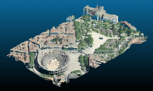
subsampled_nimes.laz* is from https://geoservices.ign.fr/lidarhd. and has been downsampled (1 point every 50cm) to make the file smaller.
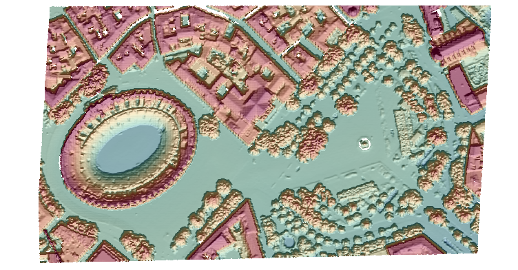
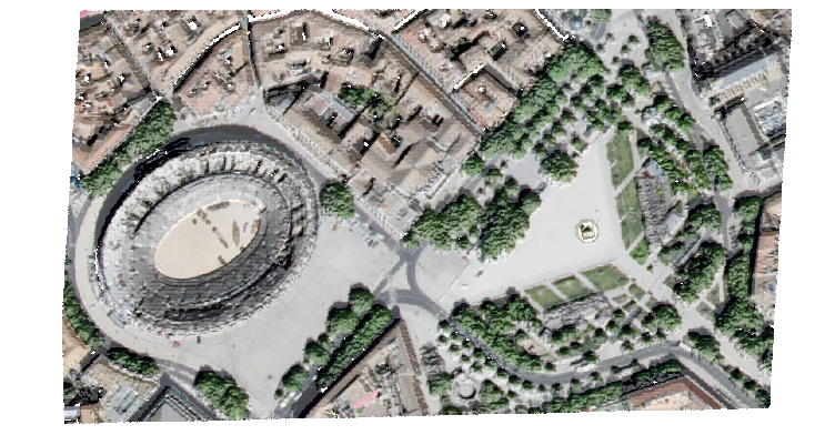
- Run las2tif executable:
las2tif subsampled_nimes.laz dsm.tif --clr_out clr.tif
- ✅ Done! The executable generates two files:
- dsm.tif: the elevation of the points (Z dimension) are projected into a regular grid to generate a raster file named Digital Surface Model.
- clr.tif: the red, the green and the blue dimensions can be also projected producing a color interpretation map superimposable on DSM
| dsm.tif | clr.tif |
|---|---|
 |
 |
How it works
A LAS file contains a set of points $P = {(x, y, z, r, g, b)_k}$ each having several dimensions:
- $x$ and $y$ correspond to planimetric information
- $z$ corresponds to the altitude
- $r$, $g$ and $b$ correspond to colorimetric information (respectively red, green, blue )
To create a raster digital surface model, we define a regular grid on a region of interest roi of origin $(x_{start}, y_{start})$, size $(x_{size}, y_{size})$ with a constant resolution.
For each cell of center $(c_x, c_y)$, we consider the subset of points contained in the disk $D$ (parameter radius) centered on this cell (see figure below):
| Contributing points |
|---|
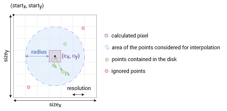
Then, the altitude assigned $z(c_x, c_y)$ to the cell is a Gaussian weighted average (standard deviation sigma $\sigma$) of the distance $d$ to its center :
$$z(c_x, c_y) = \frac{\sum_{p_k \in D} z_k e^{-d_k^2/2\sigma^2}}{\sum_{p_k \in D} e^{-d_k^2/2\sigma^2}}$$
Finally, to have a superimposable color to this dsm, the colors are averaged in the same way.
Contribution
cars-rasterize is a free software: Apache Software License 2.0. See Contribution manual.
Project details
Verified details
These details have been verified by PyPIProject links
GitHub Statistics
Maintainers


Download files
Download the file for your platform. If you're not sure which to choose, learn more about installing packages.
Source Distribution
Built Distributions
Filter files by name, interpreter, ABI, and platform.
If you're not sure about the file name format, learn more about wheel file names.
Copy a direct link to the current filters
File details
Details for the file cars_rasterize-0.2.3.tar.gz.
File metadata
- Download URL: cars_rasterize-0.2.3.tar.gz
- Upload date:
- Size: 12.9 MB
- Tags: Source
- Uploaded using Trusted Publishing? Yes
- Uploaded via: twine/6.1.0 CPython/3.12.8
File hashes
| Algorithm | Hash digest | |
|---|---|---|
| SHA256 |
bc98432a2459ef6ca5f59ca840c7da3f8a58dce791f1b0b959973b2284dfc837
|
|
| MD5 |
8112ab37c8c6f259ac90aa7abb87bd8e
|
|
| BLAKE2b-256 |
ad2ed52bc9d242fbeff89259a076c3c2cecd5962a6ca72bd032f49f378aef9ec
|
Provenance
The following attestation bundles were made for cars_rasterize-0.2.3.tar.gz:
Publisher:
create-and-publish-wheel.yml on CNES/cars-rasterize
-
Statement:
-
Statement type:
https://in-toto.io/Statement/v1 -
Predicate type:
https://docs.pypi.org/attestations/publish/v1 -
Subject name:
cars_rasterize-0.2.3.tar.gz -
Subject digest:
bc98432a2459ef6ca5f59ca840c7da3f8a58dce791f1b0b959973b2284dfc837 - Sigstore transparency entry: 172193455
- Sigstore integration time:
-
Permalink:
CNES/cars-rasterize@b40eef21e9e209fb58b62ba7d68f0298d60b0306 -
Branch / Tag:
refs/tags/0.2.3 - Owner: https://github.com/CNES
-
Access:
public
-
Token Issuer:
https://token.actions.githubusercontent.com -
Runner Environment:
github-hosted -
Publication workflow:
create-and-publish-wheel.yml@b40eef21e9e209fb58b62ba7d68f0298d60b0306 -
Trigger Event:
push
-
Statement type:
File details
Details for the file cars_rasterize-0.2.3-cp313-cp313-win_amd64.whl.
File metadata
- Download URL: cars_rasterize-0.2.3-cp313-cp313-win_amd64.whl
- Upload date:
- Size: 82.3 kB
- Tags: CPython 3.13, Windows x86-64
- Uploaded using Trusted Publishing? Yes
- Uploaded via: twine/6.1.0 CPython/3.12.8
File hashes
| Algorithm | Hash digest | |
|---|---|---|
| SHA256 |
dc0e999d8d54d603cd7d8ea0b4513e9ef25c209b98372078a60274e0a1d6ad8a
|
|
| MD5 |
09b7e168edc4b12339ec135f221748bd
|
|
| BLAKE2b-256 |
c5fbdeed6d92074cd79ee33a8d73116c63173753f7660f6462e52e8480719da1
|
Provenance
The following attestation bundles were made for cars_rasterize-0.2.3-cp313-cp313-win_amd64.whl:
Publisher:
create-and-publish-wheel.yml on CNES/cars-rasterize
-
Statement:
-
Statement type:
https://in-toto.io/Statement/v1 -
Predicate type:
https://docs.pypi.org/attestations/publish/v1 -
Subject name:
cars_rasterize-0.2.3-cp313-cp313-win_amd64.whl -
Subject digest:
dc0e999d8d54d603cd7d8ea0b4513e9ef25c209b98372078a60274e0a1d6ad8a - Sigstore transparency entry: 172193487
- Sigstore integration time:
-
Permalink:
CNES/cars-rasterize@b40eef21e9e209fb58b62ba7d68f0298d60b0306 -
Branch / Tag:
refs/tags/0.2.3 - Owner: https://github.com/CNES
-
Access:
public
-
Token Issuer:
https://token.actions.githubusercontent.com -
Runner Environment:
github-hosted -
Publication workflow:
create-and-publish-wheel.yml@b40eef21e9e209fb58b62ba7d68f0298d60b0306 -
Trigger Event:
push
-
Statement type:
File details
Details for the file cars_rasterize-0.2.3-cp313-cp313-win32.whl.
File metadata
- Download URL: cars_rasterize-0.2.3-cp313-cp313-win32.whl
- Upload date:
- Size: 73.5 kB
- Tags: CPython 3.13, Windows x86
- Uploaded using Trusted Publishing? Yes
- Uploaded via: twine/6.1.0 CPython/3.12.8
File hashes
| Algorithm | Hash digest | |
|---|---|---|
| SHA256 |
ccfb546de682eaa2cf53be9b34c255eb955de972f28332243fb2f9db13f845b4
|
|
| MD5 |
83fb4693829f15b920b18c4d3d8477b9
|
|
| BLAKE2b-256 |
c58954094928526972d03101cdb02a56322f71879ea31253c63305c72eaef623
|
Provenance
The following attestation bundles were made for cars_rasterize-0.2.3-cp313-cp313-win32.whl:
Publisher:
create-and-publish-wheel.yml on CNES/cars-rasterize
-
Statement:
-
Statement type:
https://in-toto.io/Statement/v1 -
Predicate type:
https://docs.pypi.org/attestations/publish/v1 -
Subject name:
cars_rasterize-0.2.3-cp313-cp313-win32.whl -
Subject digest:
ccfb546de682eaa2cf53be9b34c255eb955de972f28332243fb2f9db13f845b4 - Sigstore transparency entry: 172193495
- Sigstore integration time:
-
Permalink:
CNES/cars-rasterize@b40eef21e9e209fb58b62ba7d68f0298d60b0306 -
Branch / Tag:
refs/tags/0.2.3 - Owner: https://github.com/CNES
-
Access:
public
-
Token Issuer:
https://token.actions.githubusercontent.com -
Runner Environment:
github-hosted -
Publication workflow:
create-and-publish-wheel.yml@b40eef21e9e209fb58b62ba7d68f0298d60b0306 -
Trigger Event:
push
-
Statement type:
File details
Details for the file cars_rasterize-0.2.3-cp313-cp313-musllinux_1_2_x86_64.whl.
File metadata
- Download URL: cars_rasterize-0.2.3-cp313-cp313-musllinux_1_2_x86_64.whl
- Upload date:
- Size: 1.1 MB
- Tags: CPython 3.13, musllinux: musl 1.2+ x86-64
- Uploaded using Trusted Publishing? Yes
- Uploaded via: twine/6.1.0 CPython/3.12.8
File hashes
| Algorithm | Hash digest | |
|---|---|---|
| SHA256 |
89cbd246f791e9cb4eceff0a2f8a21e3f2456ed1eef5735c6002190dbd56ca9a
|
|
| MD5 |
2d9296a90e4b15b728f9c2ed37efc054
|
|
| BLAKE2b-256 |
f2a56b693020013b2e518b2c4a4be011923e3c9d29663c2d1000823def954bd1
|
Provenance
The following attestation bundles were made for cars_rasterize-0.2.3-cp313-cp313-musllinux_1_2_x86_64.whl:
Publisher:
create-and-publish-wheel.yml on CNES/cars-rasterize
-
Statement:
-
Statement type:
https://in-toto.io/Statement/v1 -
Predicate type:
https://docs.pypi.org/attestations/publish/v1 -
Subject name:
cars_rasterize-0.2.3-cp313-cp313-musllinux_1_2_x86_64.whl -
Subject digest:
89cbd246f791e9cb4eceff0a2f8a21e3f2456ed1eef5735c6002190dbd56ca9a - Sigstore transparency entry: 172193473
- Sigstore integration time:
-
Permalink:
CNES/cars-rasterize@b40eef21e9e209fb58b62ba7d68f0298d60b0306 -
Branch / Tag:
refs/tags/0.2.3 - Owner: https://github.com/CNES
-
Access:
public
-
Token Issuer:
https://token.actions.githubusercontent.com -
Runner Environment:
github-hosted -
Publication workflow:
create-and-publish-wheel.yml@b40eef21e9e209fb58b62ba7d68f0298d60b0306 -
Trigger Event:
push
-
Statement type:
File details
Details for the file cars_rasterize-0.2.3-cp313-cp313-musllinux_1_2_i686.whl.
File metadata
- Download URL: cars_rasterize-0.2.3-cp313-cp313-musllinux_1_2_i686.whl
- Upload date:
- Size: 1.2 MB
- Tags: CPython 3.13, musllinux: musl 1.2+ i686
- Uploaded using Trusted Publishing? Yes
- Uploaded via: twine/6.1.0 CPython/3.12.8
File hashes
| Algorithm | Hash digest | |
|---|---|---|
| SHA256 |
a8a32f3fa8dbc705f72adcb97589ca7a1f19c00287f1182568fa39cae5f68bc3
|
|
| MD5 |
ff1973cfbf52cab1bf3fe7505de0ae3a
|
|
| BLAKE2b-256 |
79c95641626be0c4252dbb60a33af35bd51fffc9648d144f8ab7c998b76b808c
|
Provenance
The following attestation bundles were made for cars_rasterize-0.2.3-cp313-cp313-musllinux_1_2_i686.whl:
Publisher:
create-and-publish-wheel.yml on CNES/cars-rasterize
-
Statement:
-
Statement type:
https://in-toto.io/Statement/v1 -
Predicate type:
https://docs.pypi.org/attestations/publish/v1 -
Subject name:
cars_rasterize-0.2.3-cp313-cp313-musllinux_1_2_i686.whl -
Subject digest:
a8a32f3fa8dbc705f72adcb97589ca7a1f19c00287f1182568fa39cae5f68bc3 - Sigstore transparency entry: 172193509
- Sigstore integration time:
-
Permalink:
CNES/cars-rasterize@b40eef21e9e209fb58b62ba7d68f0298d60b0306 -
Branch / Tag:
refs/tags/0.2.3 - Owner: https://github.com/CNES
-
Access:
public
-
Token Issuer:
https://token.actions.githubusercontent.com -
Runner Environment:
github-hosted -
Publication workflow:
create-and-publish-wheel.yml@b40eef21e9e209fb58b62ba7d68f0298d60b0306 -
Trigger Event:
push
-
Statement type:
File details
Details for the file cars_rasterize-0.2.3-cp313-cp313-manylinux_2_17_x86_64.manylinux2014_x86_64.whl.
File metadata
- Download URL: cars_rasterize-0.2.3-cp313-cp313-manylinux_2_17_x86_64.manylinux2014_x86_64.whl
- Upload date:
- Size: 122.3 kB
- Tags: CPython 3.13, manylinux: glibc 2.17+ x86-64
- Uploaded using Trusted Publishing? Yes
- Uploaded via: twine/6.1.0 CPython/3.12.8
File hashes
| Algorithm | Hash digest | |
|---|---|---|
| SHA256 |
8da439a707e3ad6fa445e331fb017c4ce769d8da4960e50884c7142e3cf6b0e8
|
|
| MD5 |
c4a16867d663d7f2af314db273f38784
|
|
| BLAKE2b-256 |
3d8be3c97e63bcc18d10c2561ca5f8c0bf4983fd00a303e33cab2f5c4ab585d4
|
Provenance
The following attestation bundles were made for cars_rasterize-0.2.3-cp313-cp313-manylinux_2_17_x86_64.manylinux2014_x86_64.whl:
Publisher:
create-and-publish-wheel.yml on CNES/cars-rasterize
-
Statement:
-
Statement type:
https://in-toto.io/Statement/v1 -
Predicate type:
https://docs.pypi.org/attestations/publish/v1 -
Subject name:
cars_rasterize-0.2.3-cp313-cp313-manylinux2014_x86_64.manylinux_2_17_x86_64.whl -
Subject digest:
8da439a707e3ad6fa445e331fb017c4ce769d8da4960e50884c7142e3cf6b0e8 - Sigstore transparency entry: 172193534
- Sigstore integration time:
-
Permalink:
CNES/cars-rasterize@b40eef21e9e209fb58b62ba7d68f0298d60b0306 -
Branch / Tag:
refs/tags/0.2.3 - Owner: https://github.com/CNES
-
Access:
public
-
Token Issuer:
https://token.actions.githubusercontent.com -
Runner Environment:
github-hosted -
Publication workflow:
create-and-publish-wheel.yml@b40eef21e9e209fb58b62ba7d68f0298d60b0306 -
Trigger Event:
push
-
Statement type:
File details
Details for the file cars_rasterize-0.2.3-cp313-cp313-manylinux_2_17_i686.manylinux2014_i686.whl.
File metadata
- Download URL: cars_rasterize-0.2.3-cp313-cp313-manylinux_2_17_i686.manylinux2014_i686.whl
- Upload date:
- Size: 128.1 kB
- Tags: CPython 3.13, manylinux: glibc 2.17+ i686
- Uploaded using Trusted Publishing? Yes
- Uploaded via: twine/6.1.0 CPython/3.12.8
File hashes
| Algorithm | Hash digest | |
|---|---|---|
| SHA256 |
138ef9c5b266396d5368fe5c90cdb01f4a0501809d47058ffd0772a975c6ab16
|
|
| MD5 |
c19c7025ee36ee4fc6cec39cd37c41aa
|
|
| BLAKE2b-256 |
15b98a348047957be7b505d3c605ce212bb682587acf6ac890dd7bcb4a36a160
|
Provenance
The following attestation bundles were made for cars_rasterize-0.2.3-cp313-cp313-manylinux_2_17_i686.manylinux2014_i686.whl:
Publisher:
create-and-publish-wheel.yml on CNES/cars-rasterize
-
Statement:
-
Statement type:
https://in-toto.io/Statement/v1 -
Predicate type:
https://docs.pypi.org/attestations/publish/v1 -
Subject name:
cars_rasterize-0.2.3-cp313-cp313-manylinux2014_i686.manylinux_2_17_i686.whl -
Subject digest:
138ef9c5b266396d5368fe5c90cdb01f4a0501809d47058ffd0772a975c6ab16 - Sigstore transparency entry: 172193539
- Sigstore integration time:
-
Permalink:
CNES/cars-rasterize@b40eef21e9e209fb58b62ba7d68f0298d60b0306 -
Branch / Tag:
refs/tags/0.2.3 - Owner: https://github.com/CNES
-
Access:
public
-
Token Issuer:
https://token.actions.githubusercontent.com -
Runner Environment:
github-hosted -
Publication workflow:
create-and-publish-wheel.yml@b40eef21e9e209fb58b62ba7d68f0298d60b0306 -
Trigger Event:
push
-
Statement type:
File details
Details for the file cars_rasterize-0.2.3-cp313-cp313-macosx_11_0_arm64.whl.
File metadata
- Download URL: cars_rasterize-0.2.3-cp313-cp313-macosx_11_0_arm64.whl
- Upload date:
- Size: 84.1 kB
- Tags: CPython 3.13, macOS 11.0+ ARM64
- Uploaded using Trusted Publishing? Yes
- Uploaded via: twine/6.1.0 CPython/3.12.8
File hashes
| Algorithm | Hash digest | |
|---|---|---|
| SHA256 |
862dbcaa5a798b5b17d9051738db01c52b3a67854150700105bdaa7986cb16b8
|
|
| MD5 |
b070f80b2b061a6ddc65ef0ecb027f1d
|
|
| BLAKE2b-256 |
e6e8076d6455fd365e22b0049ca53b526909202f129a7c195e863999d6a743d1
|
Provenance
The following attestation bundles were made for cars_rasterize-0.2.3-cp313-cp313-macosx_11_0_arm64.whl:
Publisher:
create-and-publish-wheel.yml on CNES/cars-rasterize
-
Statement:
-
Statement type:
https://in-toto.io/Statement/v1 -
Predicate type:
https://docs.pypi.org/attestations/publish/v1 -
Subject name:
cars_rasterize-0.2.3-cp313-cp313-macosx_11_0_arm64.whl -
Subject digest:
862dbcaa5a798b5b17d9051738db01c52b3a67854150700105bdaa7986cb16b8 - Sigstore transparency entry: 172193460
- Sigstore integration time:
-
Permalink:
CNES/cars-rasterize@b40eef21e9e209fb58b62ba7d68f0298d60b0306 -
Branch / Tag:
refs/tags/0.2.3 - Owner: https://github.com/CNES
-
Access:
public
-
Token Issuer:
https://token.actions.githubusercontent.com -
Runner Environment:
github-hosted -
Publication workflow:
create-and-publish-wheel.yml@b40eef21e9e209fb58b62ba7d68f0298d60b0306 -
Trigger Event:
push
-
Statement type:
File details
Details for the file cars_rasterize-0.2.3-cp313-cp313-macosx_10_13_x86_64.whl.
File metadata
- Download URL: cars_rasterize-0.2.3-cp313-cp313-macosx_10_13_x86_64.whl
- Upload date:
- Size: 86.7 kB
- Tags: CPython 3.13, macOS 10.13+ x86-64
- Uploaded using Trusted Publishing? Yes
- Uploaded via: twine/6.1.0 CPython/3.12.8
File hashes
| Algorithm | Hash digest | |
|---|---|---|
| SHA256 |
ede5ab5b55069162a892f0cdb380f5db9de18044412b4d8a7eae40fd405b6f50
|
|
| MD5 |
818ca8fb77dd4fa1e63970d2861a7acd
|
|
| BLAKE2b-256 |
8f0793a6b8cf1a747b73ad0f8f767d9e4f741f8479a97260cc7d3b363f7f8d95
|
Provenance
The following attestation bundles were made for cars_rasterize-0.2.3-cp313-cp313-macosx_10_13_x86_64.whl:
Publisher:
create-and-publish-wheel.yml on CNES/cars-rasterize
-
Statement:
-
Statement type:
https://in-toto.io/Statement/v1 -
Predicate type:
https://docs.pypi.org/attestations/publish/v1 -
Subject name:
cars_rasterize-0.2.3-cp313-cp313-macosx_10_13_x86_64.whl -
Subject digest:
ede5ab5b55069162a892f0cdb380f5db9de18044412b4d8a7eae40fd405b6f50 - Sigstore transparency entry: 172193507
- Sigstore integration time:
-
Permalink:
CNES/cars-rasterize@b40eef21e9e209fb58b62ba7d68f0298d60b0306 -
Branch / Tag:
refs/tags/0.2.3 - Owner: https://github.com/CNES
-
Access:
public
-
Token Issuer:
https://token.actions.githubusercontent.com -
Runner Environment:
github-hosted -
Publication workflow:
create-and-publish-wheel.yml@b40eef21e9e209fb58b62ba7d68f0298d60b0306 -
Trigger Event:
push
-
Statement type:
File details
Details for the file cars_rasterize-0.2.3-cp312-cp312-win_amd64.whl.
File metadata
- Download URL: cars_rasterize-0.2.3-cp312-cp312-win_amd64.whl
- Upload date:
- Size: 82.3 kB
- Tags: CPython 3.12, Windows x86-64
- Uploaded using Trusted Publishing? Yes
- Uploaded via: twine/6.1.0 CPython/3.12.8
File hashes
| Algorithm | Hash digest | |
|---|---|---|
| SHA256 |
ab4ff9dc93eda6cb4968f6f36200d24180ea10057bf6161939e5198bf1970c5a
|
|
| MD5 |
cee38191d0f5ed617d42e447bdae4b0a
|
|
| BLAKE2b-256 |
cb843583c047e1be8c2f4992d04295be66b4603d62394392f3f8524ed553f1e4
|
Provenance
The following attestation bundles were made for cars_rasterize-0.2.3-cp312-cp312-win_amd64.whl:
Publisher:
create-and-publish-wheel.yml on CNES/cars-rasterize
-
Statement:
-
Statement type:
https://in-toto.io/Statement/v1 -
Predicate type:
https://docs.pypi.org/attestations/publish/v1 -
Subject name:
cars_rasterize-0.2.3-cp312-cp312-win_amd64.whl -
Subject digest:
ab4ff9dc93eda6cb4968f6f36200d24180ea10057bf6161939e5198bf1970c5a - Sigstore transparency entry: 172193515
- Sigstore integration time:
-
Permalink:
CNES/cars-rasterize@b40eef21e9e209fb58b62ba7d68f0298d60b0306 -
Branch / Tag:
refs/tags/0.2.3 - Owner: https://github.com/CNES
-
Access:
public
-
Token Issuer:
https://token.actions.githubusercontent.com -
Runner Environment:
github-hosted -
Publication workflow:
create-and-publish-wheel.yml@b40eef21e9e209fb58b62ba7d68f0298d60b0306 -
Trigger Event:
push
-
Statement type:
File details
Details for the file cars_rasterize-0.2.3-cp312-cp312-win32.whl.
File metadata
- Download URL: cars_rasterize-0.2.3-cp312-cp312-win32.whl
- Upload date:
- Size: 73.5 kB
- Tags: CPython 3.12, Windows x86
- Uploaded using Trusted Publishing? Yes
- Uploaded via: twine/6.1.0 CPython/3.12.8
File hashes
| Algorithm | Hash digest | |
|---|---|---|
| SHA256 |
e5c3801e868c71b19e85380982a759faa32631790f86780477e89183dc43dbd8
|
|
| MD5 |
a395be17811c441f6d6b4aa44a99305f
|
|
| BLAKE2b-256 |
90092b2369605daa636235af34e61697b293724cbce2e1031287bc3c7d426476
|
Provenance
The following attestation bundles were made for cars_rasterize-0.2.3-cp312-cp312-win32.whl:
Publisher:
create-and-publish-wheel.yml on CNES/cars-rasterize
-
Statement:
-
Statement type:
https://in-toto.io/Statement/v1 -
Predicate type:
https://docs.pypi.org/attestations/publish/v1 -
Subject name:
cars_rasterize-0.2.3-cp312-cp312-win32.whl -
Subject digest:
e5c3801e868c71b19e85380982a759faa32631790f86780477e89183dc43dbd8 - Sigstore transparency entry: 172193492
- Sigstore integration time:
-
Permalink:
CNES/cars-rasterize@b40eef21e9e209fb58b62ba7d68f0298d60b0306 -
Branch / Tag:
refs/tags/0.2.3 - Owner: https://github.com/CNES
-
Access:
public
-
Token Issuer:
https://token.actions.githubusercontent.com -
Runner Environment:
github-hosted -
Publication workflow:
create-and-publish-wheel.yml@b40eef21e9e209fb58b62ba7d68f0298d60b0306 -
Trigger Event:
push
-
Statement type:
File details
Details for the file cars_rasterize-0.2.3-cp312-cp312-musllinux_1_2_x86_64.whl.
File metadata
- Download URL: cars_rasterize-0.2.3-cp312-cp312-musllinux_1_2_x86_64.whl
- Upload date:
- Size: 1.1 MB
- Tags: CPython 3.12, musllinux: musl 1.2+ x86-64
- Uploaded using Trusted Publishing? Yes
- Uploaded via: twine/6.1.0 CPython/3.12.8
File hashes
| Algorithm | Hash digest | |
|---|---|---|
| SHA256 |
b99e1d6cf140138819eadb9a12512218e0c0b9c2a3aa2146cc1d372828a0e9da
|
|
| MD5 |
407bdbcfb77b2bc63c56710c80ec30ac
|
|
| BLAKE2b-256 |
1c37c92abdd7bd158da6a1cd7654097af5f62eb72b14a6fcc925f4d1b6b86cba
|
Provenance
The following attestation bundles were made for cars_rasterize-0.2.3-cp312-cp312-musllinux_1_2_x86_64.whl:
Publisher:
create-and-publish-wheel.yml on CNES/cars-rasterize
-
Statement:
-
Statement type:
https://in-toto.io/Statement/v1 -
Predicate type:
https://docs.pypi.org/attestations/publish/v1 -
Subject name:
cars_rasterize-0.2.3-cp312-cp312-musllinux_1_2_x86_64.whl -
Subject digest:
b99e1d6cf140138819eadb9a12512218e0c0b9c2a3aa2146cc1d372828a0e9da - Sigstore transparency entry: 172193522
- Sigstore integration time:
-
Permalink:
CNES/cars-rasterize@b40eef21e9e209fb58b62ba7d68f0298d60b0306 -
Branch / Tag:
refs/tags/0.2.3 - Owner: https://github.com/CNES
-
Access:
public
-
Token Issuer:
https://token.actions.githubusercontent.com -
Runner Environment:
github-hosted -
Publication workflow:
create-and-publish-wheel.yml@b40eef21e9e209fb58b62ba7d68f0298d60b0306 -
Trigger Event:
push
-
Statement type:
File details
Details for the file cars_rasterize-0.2.3-cp312-cp312-musllinux_1_2_i686.whl.
File metadata
- Download URL: cars_rasterize-0.2.3-cp312-cp312-musllinux_1_2_i686.whl
- Upload date:
- Size: 1.2 MB
- Tags: CPython 3.12, musllinux: musl 1.2+ i686
- Uploaded using Trusted Publishing? Yes
- Uploaded via: twine/6.1.0 CPython/3.12.8
File hashes
| Algorithm | Hash digest | |
|---|---|---|
| SHA256 |
17b7701ffaac9b3bf6412f7f09991270dcc6f438664dfebaeb088c1538ff2093
|
|
| MD5 |
1efe72a578974c3b8e8ebc100ffc2416
|
|
| BLAKE2b-256 |
d007dca9ce84041f8860f35ecb3dba65a987d69c9b8902aa217227fe1cfb09ef
|
Provenance
The following attestation bundles were made for cars_rasterize-0.2.3-cp312-cp312-musllinux_1_2_i686.whl:
Publisher:
create-and-publish-wheel.yml on CNES/cars-rasterize
-
Statement:
-
Statement type:
https://in-toto.io/Statement/v1 -
Predicate type:
https://docs.pypi.org/attestations/publish/v1 -
Subject name:
cars_rasterize-0.2.3-cp312-cp312-musllinux_1_2_i686.whl -
Subject digest:
17b7701ffaac9b3bf6412f7f09991270dcc6f438664dfebaeb088c1538ff2093 - Sigstore transparency entry: 172193456
- Sigstore integration time:
-
Permalink:
CNES/cars-rasterize@b40eef21e9e209fb58b62ba7d68f0298d60b0306 -
Branch / Tag:
refs/tags/0.2.3 - Owner: https://github.com/CNES
-
Access:
public
-
Token Issuer:
https://token.actions.githubusercontent.com -
Runner Environment:
github-hosted -
Publication workflow:
create-and-publish-wheel.yml@b40eef21e9e209fb58b62ba7d68f0298d60b0306 -
Trigger Event:
push
-
Statement type:
File details
Details for the file cars_rasterize-0.2.3-cp312-cp312-manylinux_2_17_x86_64.manylinux2014_x86_64.whl.
File metadata
- Download URL: cars_rasterize-0.2.3-cp312-cp312-manylinux_2_17_x86_64.manylinux2014_x86_64.whl
- Upload date:
- Size: 122.2 kB
- Tags: CPython 3.12, manylinux: glibc 2.17+ x86-64
- Uploaded using Trusted Publishing? Yes
- Uploaded via: twine/6.1.0 CPython/3.12.8
File hashes
| Algorithm | Hash digest | |
|---|---|---|
| SHA256 |
48c12c14a4e177e3e8bc8db1e1f586f55f09b474d10741c84439c48cf0ede59b
|
|
| MD5 |
53074e3ef22cc8174ab38fc7aba82e9d
|
|
| BLAKE2b-256 |
6d0329787b1c18d215a15126cebd950ef273cb3cfc267efc5521093894a1eb2b
|
Provenance
The following attestation bundles were made for cars_rasterize-0.2.3-cp312-cp312-manylinux_2_17_x86_64.manylinux2014_x86_64.whl:
Publisher:
create-and-publish-wheel.yml on CNES/cars-rasterize
-
Statement:
-
Statement type:
https://in-toto.io/Statement/v1 -
Predicate type:
https://docs.pypi.org/attestations/publish/v1 -
Subject name:
cars_rasterize-0.2.3-cp312-cp312-manylinux2014_x86_64.manylinux_2_17_x86_64.whl -
Subject digest:
48c12c14a4e177e3e8bc8db1e1f586f55f09b474d10741c84439c48cf0ede59b - Sigstore transparency entry: 172193517
- Sigstore integration time:
-
Permalink:
CNES/cars-rasterize@b40eef21e9e209fb58b62ba7d68f0298d60b0306 -
Branch / Tag:
refs/tags/0.2.3 - Owner: https://github.com/CNES
-
Access:
public
-
Token Issuer:
https://token.actions.githubusercontent.com -
Runner Environment:
github-hosted -
Publication workflow:
create-and-publish-wheel.yml@b40eef21e9e209fb58b62ba7d68f0298d60b0306 -
Trigger Event:
push
-
Statement type:
File details
Details for the file cars_rasterize-0.2.3-cp312-cp312-manylinux_2_17_i686.manylinux2014_i686.whl.
File metadata
- Download URL: cars_rasterize-0.2.3-cp312-cp312-manylinux_2_17_i686.manylinux2014_i686.whl
- Upload date:
- Size: 128.2 kB
- Tags: CPython 3.12, manylinux: glibc 2.17+ i686
- Uploaded using Trusted Publishing? Yes
- Uploaded via: twine/6.1.0 CPython/3.12.8
File hashes
| Algorithm | Hash digest | |
|---|---|---|
| SHA256 |
680adf3a66760a9604c385b58cab4dfaa0ba4c0cf1682991de342e3c2f35aad1
|
|
| MD5 |
7082c06118c5ce60973674e454bdd53b
|
|
| BLAKE2b-256 |
b01c1e5539c83dd085460a3dcdec8c1c1af1f232e8ccc0ffe719e49831b38a8c
|
Provenance
The following attestation bundles were made for cars_rasterize-0.2.3-cp312-cp312-manylinux_2_17_i686.manylinux2014_i686.whl:
Publisher:
create-and-publish-wheel.yml on CNES/cars-rasterize
-
Statement:
-
Statement type:
https://in-toto.io/Statement/v1 -
Predicate type:
https://docs.pypi.org/attestations/publish/v1 -
Subject name:
cars_rasterize-0.2.3-cp312-cp312-manylinux2014_i686.manylinux_2_17_i686.whl -
Subject digest:
680adf3a66760a9604c385b58cab4dfaa0ba4c0cf1682991de342e3c2f35aad1 - Sigstore transparency entry: 172193523
- Sigstore integration time:
-
Permalink:
CNES/cars-rasterize@b40eef21e9e209fb58b62ba7d68f0298d60b0306 -
Branch / Tag:
refs/tags/0.2.3 - Owner: https://github.com/CNES
-
Access:
public
-
Token Issuer:
https://token.actions.githubusercontent.com -
Runner Environment:
github-hosted -
Publication workflow:
create-and-publish-wheel.yml@b40eef21e9e209fb58b62ba7d68f0298d60b0306 -
Trigger Event:
push
-
Statement type:
File details
Details for the file cars_rasterize-0.2.3-cp312-cp312-macosx_11_0_arm64.whl.
File metadata
- Download URL: cars_rasterize-0.2.3-cp312-cp312-macosx_11_0_arm64.whl
- Upload date:
- Size: 84.1 kB
- Tags: CPython 3.12, macOS 11.0+ ARM64
- Uploaded using Trusted Publishing? Yes
- Uploaded via: twine/6.1.0 CPython/3.12.8
File hashes
| Algorithm | Hash digest | |
|---|---|---|
| SHA256 |
fa0a361b7698b4c57ca5a3f0f5f840c92dacf52751197ce5a9b292de017cac35
|
|
| MD5 |
bf430d182d768623017c38c5256fdcf5
|
|
| BLAKE2b-256 |
8b42a94bc93ed4aa60f693ee83c9de0c1e9811799b12b4fa356b909d93332619
|
Provenance
The following attestation bundles were made for cars_rasterize-0.2.3-cp312-cp312-macosx_11_0_arm64.whl:
Publisher:
create-and-publish-wheel.yml on CNES/cars-rasterize
-
Statement:
-
Statement type:
https://in-toto.io/Statement/v1 -
Predicate type:
https://docs.pypi.org/attestations/publish/v1 -
Subject name:
cars_rasterize-0.2.3-cp312-cp312-macosx_11_0_arm64.whl -
Subject digest:
fa0a361b7698b4c57ca5a3f0f5f840c92dacf52751197ce5a9b292de017cac35 - Sigstore transparency entry: 172193470
- Sigstore integration time:
-
Permalink:
CNES/cars-rasterize@b40eef21e9e209fb58b62ba7d68f0298d60b0306 -
Branch / Tag:
refs/tags/0.2.3 - Owner: https://github.com/CNES
-
Access:
public
-
Token Issuer:
https://token.actions.githubusercontent.com -
Runner Environment:
github-hosted -
Publication workflow:
create-and-publish-wheel.yml@b40eef21e9e209fb58b62ba7d68f0298d60b0306 -
Trigger Event:
push
-
Statement type:
File details
Details for the file cars_rasterize-0.2.3-cp312-cp312-macosx_10_13_x86_64.whl.
File metadata
- Download URL: cars_rasterize-0.2.3-cp312-cp312-macosx_10_13_x86_64.whl
- Upload date:
- Size: 86.6 kB
- Tags: CPython 3.12, macOS 10.13+ x86-64
- Uploaded using Trusted Publishing? Yes
- Uploaded via: twine/6.1.0 CPython/3.12.8
File hashes
| Algorithm | Hash digest | |
|---|---|---|
| SHA256 |
9afaf0b97ccc17baf76708f6b3b49687387380cb4c00cb42922d3ae2aa7f4085
|
|
| MD5 |
c782115d91051c1f65e05bd0370a3ae0
|
|
| BLAKE2b-256 |
350317a3ea00f27c8db64c7c2de4fb6afd1c3da5a0f21bbc70d7d9b17dd00055
|
Provenance
The following attestation bundles were made for cars_rasterize-0.2.3-cp312-cp312-macosx_10_13_x86_64.whl:
Publisher:
create-and-publish-wheel.yml on CNES/cars-rasterize
-
Statement:
-
Statement type:
https://in-toto.io/Statement/v1 -
Predicate type:
https://docs.pypi.org/attestations/publish/v1 -
Subject name:
cars_rasterize-0.2.3-cp312-cp312-macosx_10_13_x86_64.whl -
Subject digest:
9afaf0b97ccc17baf76708f6b3b49687387380cb4c00cb42922d3ae2aa7f4085 - Sigstore transparency entry: 172193503
- Sigstore integration time:
-
Permalink:
CNES/cars-rasterize@b40eef21e9e209fb58b62ba7d68f0298d60b0306 -
Branch / Tag:
refs/tags/0.2.3 - Owner: https://github.com/CNES
-
Access:
public
-
Token Issuer:
https://token.actions.githubusercontent.com -
Runner Environment:
github-hosted -
Publication workflow:
create-and-publish-wheel.yml@b40eef21e9e209fb58b62ba7d68f0298d60b0306 -
Trigger Event:
push
-
Statement type:
File details
Details for the file cars_rasterize-0.2.3-cp311-cp311-win_amd64.whl.
File metadata
- Download URL: cars_rasterize-0.2.3-cp311-cp311-win_amd64.whl
- Upload date:
- Size: 82.0 kB
- Tags: CPython 3.11, Windows x86-64
- Uploaded using Trusted Publishing? Yes
- Uploaded via: twine/6.1.0 CPython/3.12.8
File hashes
| Algorithm | Hash digest | |
|---|---|---|
| SHA256 |
85d68c223c84c74d8c3a17a37e81e356b69a4c066c8dd3810800fe4f25350079
|
|
| MD5 |
44347052021aa2b424cbbf427151ae14
|
|
| BLAKE2b-256 |
82bd87f008c73119aeaec000c3ec6ff7e9b9d99847d423c30272ac58efd90fd4
|
Provenance
The following attestation bundles were made for cars_rasterize-0.2.3-cp311-cp311-win_amd64.whl:
Publisher:
create-and-publish-wheel.yml on CNES/cars-rasterize
-
Statement:
-
Statement type:
https://in-toto.io/Statement/v1 -
Predicate type:
https://docs.pypi.org/attestations/publish/v1 -
Subject name:
cars_rasterize-0.2.3-cp311-cp311-win_amd64.whl -
Subject digest:
85d68c223c84c74d8c3a17a37e81e356b69a4c066c8dd3810800fe4f25350079 - Sigstore transparency entry: 172193526
- Sigstore integration time:
-
Permalink:
CNES/cars-rasterize@b40eef21e9e209fb58b62ba7d68f0298d60b0306 -
Branch / Tag:
refs/tags/0.2.3 - Owner: https://github.com/CNES
-
Access:
public
-
Token Issuer:
https://token.actions.githubusercontent.com -
Runner Environment:
github-hosted -
Publication workflow:
create-and-publish-wheel.yml@b40eef21e9e209fb58b62ba7d68f0298d60b0306 -
Trigger Event:
push
-
Statement type:
File details
Details for the file cars_rasterize-0.2.3-cp311-cp311-win32.whl.
File metadata
- Download URL: cars_rasterize-0.2.3-cp311-cp311-win32.whl
- Upload date:
- Size: 73.7 kB
- Tags: CPython 3.11, Windows x86
- Uploaded using Trusted Publishing? Yes
- Uploaded via: twine/6.1.0 CPython/3.12.8
File hashes
| Algorithm | Hash digest | |
|---|---|---|
| SHA256 |
3e9ab847631c8fd362da2bb19b1d73558215fd1cfc94a42921574cfdc60f9570
|
|
| MD5 |
4f0f5587715ca9c81474528ddff9c570
|
|
| BLAKE2b-256 |
c03a933daa81cfcdf10413b37e81d07552d7d704e4d5e949db08cc0fd69c84ca
|
Provenance
The following attestation bundles were made for cars_rasterize-0.2.3-cp311-cp311-win32.whl:
Publisher:
create-and-publish-wheel.yml on CNES/cars-rasterize
-
Statement:
-
Statement type:
https://in-toto.io/Statement/v1 -
Predicate type:
https://docs.pypi.org/attestations/publish/v1 -
Subject name:
cars_rasterize-0.2.3-cp311-cp311-win32.whl -
Subject digest:
3e9ab847631c8fd362da2bb19b1d73558215fd1cfc94a42921574cfdc60f9570 - Sigstore transparency entry: 172193462
- Sigstore integration time:
-
Permalink:
CNES/cars-rasterize@b40eef21e9e209fb58b62ba7d68f0298d60b0306 -
Branch / Tag:
refs/tags/0.2.3 - Owner: https://github.com/CNES
-
Access:
public
-
Token Issuer:
https://token.actions.githubusercontent.com -
Runner Environment:
github-hosted -
Publication workflow:
create-and-publish-wheel.yml@b40eef21e9e209fb58b62ba7d68f0298d60b0306 -
Trigger Event:
push
-
Statement type:
File details
Details for the file cars_rasterize-0.2.3-cp311-cp311-musllinux_1_2_x86_64.whl.
File metadata
- Download URL: cars_rasterize-0.2.3-cp311-cp311-musllinux_1_2_x86_64.whl
- Upload date:
- Size: 1.1 MB
- Tags: CPython 3.11, musllinux: musl 1.2+ x86-64
- Uploaded using Trusted Publishing? Yes
- Uploaded via: twine/6.1.0 CPython/3.12.8
File hashes
| Algorithm | Hash digest | |
|---|---|---|
| SHA256 |
b143b62a1b34abe11c873934dbc04ff2b828646532b3040ddcb3f69b023f0444
|
|
| MD5 |
574e3880d8321c1c563b829364c7b361
|
|
| BLAKE2b-256 |
43f1109bc4c81ea98bc5264f88c92a36b7be24c34764eb62c8f567f5c31a4c63
|
Provenance
The following attestation bundles were made for cars_rasterize-0.2.3-cp311-cp311-musllinux_1_2_x86_64.whl:
Publisher:
create-and-publish-wheel.yml on CNES/cars-rasterize
-
Statement:
-
Statement type:
https://in-toto.io/Statement/v1 -
Predicate type:
https://docs.pypi.org/attestations/publish/v1 -
Subject name:
cars_rasterize-0.2.3-cp311-cp311-musllinux_1_2_x86_64.whl -
Subject digest:
b143b62a1b34abe11c873934dbc04ff2b828646532b3040ddcb3f69b023f0444 - Sigstore transparency entry: 172193486
- Sigstore integration time:
-
Permalink:
CNES/cars-rasterize@b40eef21e9e209fb58b62ba7d68f0298d60b0306 -
Branch / Tag:
refs/tags/0.2.3 - Owner: https://github.com/CNES
-
Access:
public
-
Token Issuer:
https://token.actions.githubusercontent.com -
Runner Environment:
github-hosted -
Publication workflow:
create-and-publish-wheel.yml@b40eef21e9e209fb58b62ba7d68f0298d60b0306 -
Trigger Event:
push
-
Statement type:
File details
Details for the file cars_rasterize-0.2.3-cp311-cp311-musllinux_1_2_i686.whl.
File metadata
- Download URL: cars_rasterize-0.2.3-cp311-cp311-musllinux_1_2_i686.whl
- Upload date:
- Size: 1.2 MB
- Tags: CPython 3.11, musllinux: musl 1.2+ i686
- Uploaded using Trusted Publishing? Yes
- Uploaded via: twine/6.1.0 CPython/3.12.8
File hashes
| Algorithm | Hash digest | |
|---|---|---|
| SHA256 |
c47a2b1decdbc178b83ccc45936a6c51b19995a655da94674376a42f205e578e
|
|
| MD5 |
ecab7765432db773b0ed68d5e06f39e8
|
|
| BLAKE2b-256 |
2883d849bc6ad97fe322d45c95169492cab6565c3a91405e7c25c36fe742b8ef
|
Provenance
The following attestation bundles were made for cars_rasterize-0.2.3-cp311-cp311-musllinux_1_2_i686.whl:
Publisher:
create-and-publish-wheel.yml on CNES/cars-rasterize
-
Statement:
-
Statement type:
https://in-toto.io/Statement/v1 -
Predicate type:
https://docs.pypi.org/attestations/publish/v1 -
Subject name:
cars_rasterize-0.2.3-cp311-cp311-musllinux_1_2_i686.whl -
Subject digest:
c47a2b1decdbc178b83ccc45936a6c51b19995a655da94674376a42f205e578e - Sigstore transparency entry: 172193468
- Sigstore integration time:
-
Permalink:
CNES/cars-rasterize@b40eef21e9e209fb58b62ba7d68f0298d60b0306 -
Branch / Tag:
refs/tags/0.2.3 - Owner: https://github.com/CNES
-
Access:
public
-
Token Issuer:
https://token.actions.githubusercontent.com -
Runner Environment:
github-hosted -
Publication workflow:
create-and-publish-wheel.yml@b40eef21e9e209fb58b62ba7d68f0298d60b0306 -
Trigger Event:
push
-
Statement type:
File details
Details for the file cars_rasterize-0.2.3-cp311-cp311-manylinux_2_17_x86_64.manylinux2014_x86_64.whl.
File metadata
- Download URL: cars_rasterize-0.2.3-cp311-cp311-manylinux_2_17_x86_64.manylinux2014_x86_64.whl
- Upload date:
- Size: 122.4 kB
- Tags: CPython 3.11, manylinux: glibc 2.17+ x86-64
- Uploaded using Trusted Publishing? Yes
- Uploaded via: twine/6.1.0 CPython/3.12.8
File hashes
| Algorithm | Hash digest | |
|---|---|---|
| SHA256 |
df521e9133c28f57b7ff5ced9664f0fe5a69be538c7b869654e634ccc064b514
|
|
| MD5 |
bbac1fe6394b124ec6dc477acf2d3495
|
|
| BLAKE2b-256 |
9bcc79b38d2f889253b86d2fd298f0bbcbe4ab78393f2467ffeb66f555a06987
|
Provenance
The following attestation bundles were made for cars_rasterize-0.2.3-cp311-cp311-manylinux_2_17_x86_64.manylinux2014_x86_64.whl:
Publisher:
create-and-publish-wheel.yml on CNES/cars-rasterize
-
Statement:
-
Statement type:
https://in-toto.io/Statement/v1 -
Predicate type:
https://docs.pypi.org/attestations/publish/v1 -
Subject name:
cars_rasterize-0.2.3-cp311-cp311-manylinux2014_x86_64.manylinux_2_17_x86_64.whl -
Subject digest:
df521e9133c28f57b7ff5ced9664f0fe5a69be538c7b869654e634ccc064b514 - Sigstore transparency entry: 172193476
- Sigstore integration time:
-
Permalink:
CNES/cars-rasterize@b40eef21e9e209fb58b62ba7d68f0298d60b0306 -
Branch / Tag:
refs/tags/0.2.3 - Owner: https://github.com/CNES
-
Access:
public
-
Token Issuer:
https://token.actions.githubusercontent.com -
Runner Environment:
github-hosted -
Publication workflow:
create-and-publish-wheel.yml@b40eef21e9e209fb58b62ba7d68f0298d60b0306 -
Trigger Event:
push
-
Statement type:
File details
Details for the file cars_rasterize-0.2.3-cp311-cp311-manylinux_2_17_i686.manylinux2014_i686.whl.
File metadata
- Download URL: cars_rasterize-0.2.3-cp311-cp311-manylinux_2_17_i686.manylinux2014_i686.whl
- Upload date:
- Size: 127.9 kB
- Tags: CPython 3.11, manylinux: glibc 2.17+ i686
- Uploaded using Trusted Publishing? Yes
- Uploaded via: twine/6.1.0 CPython/3.12.8
File hashes
| Algorithm | Hash digest | |
|---|---|---|
| SHA256 |
764f1d3b5a44ce05f992b0eab60910e8aa7d8aaf2d2c9f7e1a63687cee3b2940
|
|
| MD5 |
f1f1bd541c27e453f7cafdb1f9dbbebe
|
|
| BLAKE2b-256 |
376cb97a8f830281a7ff82c5e55dd103f55f13990bc1ccb276dc5bd66a35d5e8
|
Provenance
The following attestation bundles were made for cars_rasterize-0.2.3-cp311-cp311-manylinux_2_17_i686.manylinux2014_i686.whl:
Publisher:
create-and-publish-wheel.yml on CNES/cars-rasterize
-
Statement:
-
Statement type:
https://in-toto.io/Statement/v1 -
Predicate type:
https://docs.pypi.org/attestations/publish/v1 -
Subject name:
cars_rasterize-0.2.3-cp311-cp311-manylinux2014_i686.manylinux_2_17_i686.whl -
Subject digest:
764f1d3b5a44ce05f992b0eab60910e8aa7d8aaf2d2c9f7e1a63687cee3b2940 - Sigstore transparency entry: 172193505
- Sigstore integration time:
-
Permalink:
CNES/cars-rasterize@b40eef21e9e209fb58b62ba7d68f0298d60b0306 -
Branch / Tag:
refs/tags/0.2.3 - Owner: https://github.com/CNES
-
Access:
public
-
Token Issuer:
https://token.actions.githubusercontent.com -
Runner Environment:
github-hosted -
Publication workflow:
create-and-publish-wheel.yml@b40eef21e9e209fb58b62ba7d68f0298d60b0306 -
Trigger Event:
push
-
Statement type:
File details
Details for the file cars_rasterize-0.2.3-cp311-cp311-macosx_11_0_arm64.whl.
File metadata
- Download URL: cars_rasterize-0.2.3-cp311-cp311-macosx_11_0_arm64.whl
- Upload date:
- Size: 85.7 kB
- Tags: CPython 3.11, macOS 11.0+ ARM64
- Uploaded using Trusted Publishing? Yes
- Uploaded via: twine/6.1.0 CPython/3.12.8
File hashes
| Algorithm | Hash digest | |
|---|---|---|
| SHA256 |
db8343eb57b59b5cd01c13a994840ccc301daa2aab5bab7eafee442d14e31c91
|
|
| MD5 |
6ecbab13742bfd3d831fd0fee1513793
|
|
| BLAKE2b-256 |
9a4b1dd360074d78062a43edd748e200cbfa2b22917f2b403d57fc8e09ece25a
|
Provenance
The following attestation bundles were made for cars_rasterize-0.2.3-cp311-cp311-macosx_11_0_arm64.whl:
Publisher:
create-and-publish-wheel.yml on CNES/cars-rasterize
-
Statement:
-
Statement type:
https://in-toto.io/Statement/v1 -
Predicate type:
https://docs.pypi.org/attestations/publish/v1 -
Subject name:
cars_rasterize-0.2.3-cp311-cp311-macosx_11_0_arm64.whl -
Subject digest:
db8343eb57b59b5cd01c13a994840ccc301daa2aab5bab7eafee442d14e31c91 - Sigstore transparency entry: 172193480
- Sigstore integration time:
-
Permalink:
CNES/cars-rasterize@b40eef21e9e209fb58b62ba7d68f0298d60b0306 -
Branch / Tag:
refs/tags/0.2.3 - Owner: https://github.com/CNES
-
Access:
public
-
Token Issuer:
https://token.actions.githubusercontent.com -
Runner Environment:
github-hosted -
Publication workflow:
create-and-publish-wheel.yml@b40eef21e9e209fb58b62ba7d68f0298d60b0306 -
Trigger Event:
push
-
Statement type:
File details
Details for the file cars_rasterize-0.2.3-cp311-cp311-macosx_10_9_x86_64.whl.
File metadata
- Download URL: cars_rasterize-0.2.3-cp311-cp311-macosx_10_9_x86_64.whl
- Upload date:
- Size: 87.9 kB
- Tags: CPython 3.11, macOS 10.9+ x86-64
- Uploaded using Trusted Publishing? Yes
- Uploaded via: twine/6.1.0 CPython/3.12.8
File hashes
| Algorithm | Hash digest | |
|---|---|---|
| SHA256 |
2fc7ee31dfca413425346f4218ed46339d567b11bf557114d6d16fa065ce5a4e
|
|
| MD5 |
381ee58b5f21921852e52c009c9f485e
|
|
| BLAKE2b-256 |
cd23a97b6e2249fa53a4cf2de55b065eef02bc2509a51ee6194c103972b4a31d
|
Provenance
The following attestation bundles were made for cars_rasterize-0.2.3-cp311-cp311-macosx_10_9_x86_64.whl:
Publisher:
create-and-publish-wheel.yml on CNES/cars-rasterize
-
Statement:
-
Statement type:
https://in-toto.io/Statement/v1 -
Predicate type:
https://docs.pypi.org/attestations/publish/v1 -
Subject name:
cars_rasterize-0.2.3-cp311-cp311-macosx_10_9_x86_64.whl -
Subject digest:
2fc7ee31dfca413425346f4218ed46339d567b11bf557114d6d16fa065ce5a4e - Sigstore transparency entry: 172193478
- Sigstore integration time:
-
Permalink:
CNES/cars-rasterize@b40eef21e9e209fb58b62ba7d68f0298d60b0306 -
Branch / Tag:
refs/tags/0.2.3 - Owner: https://github.com/CNES
-
Access:
public
-
Token Issuer:
https://token.actions.githubusercontent.com -
Runner Environment:
github-hosted -
Publication workflow:
create-and-publish-wheel.yml@b40eef21e9e209fb58b62ba7d68f0298d60b0306 -
Trigger Event:
push
-
Statement type:
File details
Details for the file cars_rasterize-0.2.3-cp310-cp310-win_amd64.whl.
File metadata
- Download URL: cars_rasterize-0.2.3-cp310-cp310-win_amd64.whl
- Upload date:
- Size: 81.0 kB
- Tags: CPython 3.10, Windows x86-64
- Uploaded using Trusted Publishing? Yes
- Uploaded via: twine/6.1.0 CPython/3.12.8
File hashes
| Algorithm | Hash digest | |
|---|---|---|
| SHA256 |
7e109027f67dacfc460e0db35f446cd75737edabddba9bdd763acead15fd94da
|
|
| MD5 |
b01c2b2aaf9e06b47c343703cd5bedf8
|
|
| BLAKE2b-256 |
c461c9030eccf46bb36fbb4a0fe4357738812a3d85b01db14e648c4e2763db48
|
Provenance
The following attestation bundles were made for cars_rasterize-0.2.3-cp310-cp310-win_amd64.whl:
Publisher:
create-and-publish-wheel.yml on CNES/cars-rasterize
-
Statement:
-
Statement type:
https://in-toto.io/Statement/v1 -
Predicate type:
https://docs.pypi.org/attestations/publish/v1 -
Subject name:
cars_rasterize-0.2.3-cp310-cp310-win_amd64.whl -
Subject digest:
7e109027f67dacfc460e0db35f446cd75737edabddba9bdd763acead15fd94da - Sigstore transparency entry: 172193483
- Sigstore integration time:
-
Permalink:
CNES/cars-rasterize@b40eef21e9e209fb58b62ba7d68f0298d60b0306 -
Branch / Tag:
refs/tags/0.2.3 - Owner: https://github.com/CNES
-
Access:
public
-
Token Issuer:
https://token.actions.githubusercontent.com -
Runner Environment:
github-hosted -
Publication workflow:
create-and-publish-wheel.yml@b40eef21e9e209fb58b62ba7d68f0298d60b0306 -
Trigger Event:
push
-
Statement type:
File details
Details for the file cars_rasterize-0.2.3-cp310-cp310-win32.whl.
File metadata
- Download URL: cars_rasterize-0.2.3-cp310-cp310-win32.whl
- Upload date:
- Size: 72.7 kB
- Tags: CPython 3.10, Windows x86
- Uploaded using Trusted Publishing? Yes
- Uploaded via: twine/6.1.0 CPython/3.12.8
File hashes
| Algorithm | Hash digest | |
|---|---|---|
| SHA256 |
8647f7da856272ac4112fc440274553987a3572ad238cf933725a0566dffc60a
|
|
| MD5 |
e1c27bd3238094f723df44c499e916fd
|
|
| BLAKE2b-256 |
d7792decf4aca5fda449bb2418f722f202e776426604bf507b29a96e36c85328
|
Provenance
The following attestation bundles were made for cars_rasterize-0.2.3-cp310-cp310-win32.whl:
Publisher:
create-and-publish-wheel.yml on CNES/cars-rasterize
-
Statement:
-
Statement type:
https://in-toto.io/Statement/v1 -
Predicate type:
https://docs.pypi.org/attestations/publish/v1 -
Subject name:
cars_rasterize-0.2.3-cp310-cp310-win32.whl -
Subject digest:
8647f7da856272ac4112fc440274553987a3572ad238cf933725a0566dffc60a - Sigstore transparency entry: 172193485
- Sigstore integration time:
-
Permalink:
CNES/cars-rasterize@b40eef21e9e209fb58b62ba7d68f0298d60b0306 -
Branch / Tag:
refs/tags/0.2.3 - Owner: https://github.com/CNES
-
Access:
public
-
Token Issuer:
https://token.actions.githubusercontent.com -
Runner Environment:
github-hosted -
Publication workflow:
create-and-publish-wheel.yml@b40eef21e9e209fb58b62ba7d68f0298d60b0306 -
Trigger Event:
push
-
Statement type:
File details
Details for the file cars_rasterize-0.2.3-cp310-cp310-musllinux_1_2_x86_64.whl.
File metadata
- Download URL: cars_rasterize-0.2.3-cp310-cp310-musllinux_1_2_x86_64.whl
- Upload date:
- Size: 1.1 MB
- Tags: CPython 3.10, musllinux: musl 1.2+ x86-64
- Uploaded using Trusted Publishing? Yes
- Uploaded via: twine/6.1.0 CPython/3.12.8
File hashes
| Algorithm | Hash digest | |
|---|---|---|
| SHA256 |
4a29d1ceffbb2364f460f5faaee4f81c0047b1933d21a570c4d15c1bfc814373
|
|
| MD5 |
8134e905ab839e0c46191d40ae0c810c
|
|
| BLAKE2b-256 |
ac065235d46e66bb5fa780f673caab5edfd7edbb264e568e0b1b48d8d5e66e22
|
Provenance
The following attestation bundles were made for cars_rasterize-0.2.3-cp310-cp310-musllinux_1_2_x86_64.whl:
Publisher:
create-and-publish-wheel.yml on CNES/cars-rasterize
-
Statement:
-
Statement type:
https://in-toto.io/Statement/v1 -
Predicate type:
https://docs.pypi.org/attestations/publish/v1 -
Subject name:
cars_rasterize-0.2.3-cp310-cp310-musllinux_1_2_x86_64.whl -
Subject digest:
4a29d1ceffbb2364f460f5faaee4f81c0047b1933d21a570c4d15c1bfc814373 - Sigstore transparency entry: 172193521
- Sigstore integration time:
-
Permalink:
CNES/cars-rasterize@b40eef21e9e209fb58b62ba7d68f0298d60b0306 -
Branch / Tag:
refs/tags/0.2.3 - Owner: https://github.com/CNES
-
Access:
public
-
Token Issuer:
https://token.actions.githubusercontent.com -
Runner Environment:
github-hosted -
Publication workflow:
create-and-publish-wheel.yml@b40eef21e9e209fb58b62ba7d68f0298d60b0306 -
Trigger Event:
push
-
Statement type:
File details
Details for the file cars_rasterize-0.2.3-cp310-cp310-musllinux_1_2_i686.whl.
File metadata
- Download URL: cars_rasterize-0.2.3-cp310-cp310-musllinux_1_2_i686.whl
- Upload date:
- Size: 1.2 MB
- Tags: CPython 3.10, musllinux: musl 1.2+ i686
- Uploaded using Trusted Publishing? Yes
- Uploaded via: twine/6.1.0 CPython/3.12.8
File hashes
| Algorithm | Hash digest | |
|---|---|---|
| SHA256 |
dd5151f99e93fa7e3e5535210838261d5224e3fcb57ee286e5f79b20c70dca48
|
|
| MD5 |
82561d4682714f6933603e22e05e4466
|
|
| BLAKE2b-256 |
9fa543b036dd325dab686d8a93d0fc557762fbf050af25f4707d397a6aada277
|
Provenance
The following attestation bundles were made for cars_rasterize-0.2.3-cp310-cp310-musllinux_1_2_i686.whl:
Publisher:
create-and-publish-wheel.yml on CNES/cars-rasterize
-
Statement:
-
Statement type:
https://in-toto.io/Statement/v1 -
Predicate type:
https://docs.pypi.org/attestations/publish/v1 -
Subject name:
cars_rasterize-0.2.3-cp310-cp310-musllinux_1_2_i686.whl -
Subject digest:
dd5151f99e93fa7e3e5535210838261d5224e3fcb57ee286e5f79b20c70dca48 - Sigstore transparency entry: 172193481
- Sigstore integration time:
-
Permalink:
CNES/cars-rasterize@b40eef21e9e209fb58b62ba7d68f0298d60b0306 -
Branch / Tag:
refs/tags/0.2.3 - Owner: https://github.com/CNES
-
Access:
public
-
Token Issuer:
https://token.actions.githubusercontent.com -
Runner Environment:
github-hosted -
Publication workflow:
create-and-publish-wheel.yml@b40eef21e9e209fb58b62ba7d68f0298d60b0306 -
Trigger Event:
push
-
Statement type:
File details
Details for the file cars_rasterize-0.2.3-cp310-cp310-manylinux_2_17_x86_64.manylinux2014_x86_64.whl.
File metadata
- Download URL: cars_rasterize-0.2.3-cp310-cp310-manylinux_2_17_x86_64.manylinux2014_x86_64.whl
- Upload date:
- Size: 121.4 kB
- Tags: CPython 3.10, manylinux: glibc 2.17+ x86-64
- Uploaded using Trusted Publishing? Yes
- Uploaded via: twine/6.1.0 CPython/3.12.8
File hashes
| Algorithm | Hash digest | |
|---|---|---|
| SHA256 |
79a50fa00c567842d2575710c9445714c50f036a398ec849f1ec03223cb3be5a
|
|
| MD5 |
f7af186b7cc1fb8d5c95f65a8ac8877f
|
|
| BLAKE2b-256 |
945c0b89737e8bc8660b49f6ab96771449be4a9b67b8bf107d85c001408212db
|
Provenance
The following attestation bundles were made for cars_rasterize-0.2.3-cp310-cp310-manylinux_2_17_x86_64.manylinux2014_x86_64.whl:
Publisher:
create-and-publish-wheel.yml on CNES/cars-rasterize
-
Statement:
-
Statement type:
https://in-toto.io/Statement/v1 -
Predicate type:
https://docs.pypi.org/attestations/publish/v1 -
Subject name:
cars_rasterize-0.2.3-cp310-cp310-manylinux2014_x86_64.manylinux_2_17_x86_64.whl -
Subject digest:
79a50fa00c567842d2575710c9445714c50f036a398ec849f1ec03223cb3be5a - Sigstore transparency entry: 172193524
- Sigstore integration time:
-
Permalink:
CNES/cars-rasterize@b40eef21e9e209fb58b62ba7d68f0298d60b0306 -
Branch / Tag:
refs/tags/0.2.3 - Owner: https://github.com/CNES
-
Access:
public
-
Token Issuer:
https://token.actions.githubusercontent.com -
Runner Environment:
github-hosted -
Publication workflow:
create-and-publish-wheel.yml@b40eef21e9e209fb58b62ba7d68f0298d60b0306 -
Trigger Event:
push
-
Statement type:
File details
Details for the file cars_rasterize-0.2.3-cp310-cp310-manylinux_2_17_i686.manylinux2014_i686.whl.
File metadata
- Download URL: cars_rasterize-0.2.3-cp310-cp310-manylinux_2_17_i686.manylinux2014_i686.whl
- Upload date:
- Size: 127.0 kB
- Tags: CPython 3.10, manylinux: glibc 2.17+ i686
- Uploaded using Trusted Publishing? Yes
- Uploaded via: twine/6.1.0 CPython/3.12.8
File hashes
| Algorithm | Hash digest | |
|---|---|---|
| SHA256 |
ac605e90114aa3b73cd938dad66171eed98dd517e1f219cf2bebbd270c5c9074
|
|
| MD5 |
0c50184bf3208eb33a8c9200f0d36803
|
|
| BLAKE2b-256 |
aeffde1455899d5c38d3c35739ae28f5466be32636992adffdf9cdeaa61a2fec
|
Provenance
The following attestation bundles were made for cars_rasterize-0.2.3-cp310-cp310-manylinux_2_17_i686.manylinux2014_i686.whl:
Publisher:
create-and-publish-wheel.yml on CNES/cars-rasterize
-
Statement:
-
Statement type:
https://in-toto.io/Statement/v1 -
Predicate type:
https://docs.pypi.org/attestations/publish/v1 -
Subject name:
cars_rasterize-0.2.3-cp310-cp310-manylinux2014_i686.manylinux_2_17_i686.whl -
Subject digest:
ac605e90114aa3b73cd938dad66171eed98dd517e1f219cf2bebbd270c5c9074 - Sigstore transparency entry: 172193500
- Sigstore integration time:
-
Permalink:
CNES/cars-rasterize@b40eef21e9e209fb58b62ba7d68f0298d60b0306 -
Branch / Tag:
refs/tags/0.2.3 - Owner: https://github.com/CNES
-
Access:
public
-
Token Issuer:
https://token.actions.githubusercontent.com -
Runner Environment:
github-hosted -
Publication workflow:
create-and-publish-wheel.yml@b40eef21e9e209fb58b62ba7d68f0298d60b0306 -
Trigger Event:
push
-
Statement type:
File details
Details for the file cars_rasterize-0.2.3-cp310-cp310-macosx_11_0_arm64.whl.
File metadata
- Download URL: cars_rasterize-0.2.3-cp310-cp310-macosx_11_0_arm64.whl
- Upload date:
- Size: 84.1 kB
- Tags: CPython 3.10, macOS 11.0+ ARM64
- Uploaded using Trusted Publishing? Yes
- Uploaded via: twine/6.1.0 CPython/3.12.8
File hashes
| Algorithm | Hash digest | |
|---|---|---|
| SHA256 |
d610e49924519621dc9d073d7424f64cc551b2627cc094afffb88f1aad68cf7a
|
|
| MD5 |
3a3b4ea7b820bf15ecc3c9f65b1d2ec4
|
|
| BLAKE2b-256 |
19f83f623c5ce6b7040c498420a1b44c2d61cbd0f0d74c8b03f0c8f9c6ee40fb
|
Provenance
The following attestation bundles were made for cars_rasterize-0.2.3-cp310-cp310-macosx_11_0_arm64.whl:
Publisher:
create-and-publish-wheel.yml on CNES/cars-rasterize
-
Statement:
-
Statement type:
https://in-toto.io/Statement/v1 -
Predicate type:
https://docs.pypi.org/attestations/publish/v1 -
Subject name:
cars_rasterize-0.2.3-cp310-cp310-macosx_11_0_arm64.whl -
Subject digest:
d610e49924519621dc9d073d7424f64cc551b2627cc094afffb88f1aad68cf7a - Sigstore transparency entry: 172193466
- Sigstore integration time:
-
Permalink:
CNES/cars-rasterize@b40eef21e9e209fb58b62ba7d68f0298d60b0306 -
Branch / Tag:
refs/tags/0.2.3 - Owner: https://github.com/CNES
-
Access:
public
-
Token Issuer:
https://token.actions.githubusercontent.com -
Runner Environment:
github-hosted -
Publication workflow:
create-and-publish-wheel.yml@b40eef21e9e209fb58b62ba7d68f0298d60b0306 -
Trigger Event:
push
-
Statement type:
File details
Details for the file cars_rasterize-0.2.3-cp310-cp310-macosx_10_9_x86_64.whl.
File metadata
- Download URL: cars_rasterize-0.2.3-cp310-cp310-macosx_10_9_x86_64.whl
- Upload date:
- Size: 86.3 kB
- Tags: CPython 3.10, macOS 10.9+ x86-64
- Uploaded using Trusted Publishing? Yes
- Uploaded via: twine/6.1.0 CPython/3.12.8
File hashes
| Algorithm | Hash digest | |
|---|---|---|
| SHA256 |
ea4375740a27d02ac266967baec9b8b84e96b30257531e1643920f4758f0dd6b
|
|
| MD5 |
eaff113d7b321d3714a94fdcb803673c
|
|
| BLAKE2b-256 |
31c3890d4348be08738713627ea4083eb539c2ee3a24b9a9df651031beab10c5
|
Provenance
The following attestation bundles were made for cars_rasterize-0.2.3-cp310-cp310-macosx_10_9_x86_64.whl:
Publisher:
create-and-publish-wheel.yml on CNES/cars-rasterize
-
Statement:
-
Statement type:
https://in-toto.io/Statement/v1 -
Predicate type:
https://docs.pypi.org/attestations/publish/v1 -
Subject name:
cars_rasterize-0.2.3-cp310-cp310-macosx_10_9_x86_64.whl -
Subject digest:
ea4375740a27d02ac266967baec9b8b84e96b30257531e1643920f4758f0dd6b - Sigstore transparency entry: 172193511
- Sigstore integration time:
-
Permalink:
CNES/cars-rasterize@b40eef21e9e209fb58b62ba7d68f0298d60b0306 -
Branch / Tag:
refs/tags/0.2.3 - Owner: https://github.com/CNES
-
Access:
public
-
Token Issuer:
https://token.actions.githubusercontent.com -
Runner Environment:
github-hosted -
Publication workflow:
create-and-publish-wheel.yml@b40eef21e9e209fb58b62ba7d68f0298d60b0306 -
Trigger Event:
push
-
Statement type:
File details
Details for the file cars_rasterize-0.2.3-cp39-cp39-win_amd64.whl.
File metadata
- Download URL: cars_rasterize-0.2.3-cp39-cp39-win_amd64.whl
- Upload date:
- Size: 80.8 kB
- Tags: CPython 3.9, Windows x86-64
- Uploaded using Trusted Publishing? Yes
- Uploaded via: twine/6.1.0 CPython/3.12.8
File hashes
| Algorithm | Hash digest | |
|---|---|---|
| SHA256 |
cc1da4aa36688880f690754e1a614aa270019d0d90044d8bfd4238ea11218a03
|
|
| MD5 |
3c7b8d33657b4c2be15a234310e00d62
|
|
| BLAKE2b-256 |
a9dd03eef31b23dcd5b0e200a56470ddc1d6dd492c83d93d1aa54b4134ffb9be
|
Provenance
The following attestation bundles were made for cars_rasterize-0.2.3-cp39-cp39-win_amd64.whl:
Publisher:
create-and-publish-wheel.yml on CNES/cars-rasterize
-
Statement:
-
Statement type:
https://in-toto.io/Statement/v1 -
Predicate type:
https://docs.pypi.org/attestations/publish/v1 -
Subject name:
cars_rasterize-0.2.3-cp39-cp39-win_amd64.whl -
Subject digest:
cc1da4aa36688880f690754e1a614aa270019d0d90044d8bfd4238ea11218a03 - Sigstore transparency entry: 172193501
- Sigstore integration time:
-
Permalink:
CNES/cars-rasterize@b40eef21e9e209fb58b62ba7d68f0298d60b0306 -
Branch / Tag:
refs/tags/0.2.3 - Owner: https://github.com/CNES
-
Access:
public
-
Token Issuer:
https://token.actions.githubusercontent.com -
Runner Environment:
github-hosted -
Publication workflow:
create-and-publish-wheel.yml@b40eef21e9e209fb58b62ba7d68f0298d60b0306 -
Trigger Event:
push
-
Statement type:
File details
Details for the file cars_rasterize-0.2.3-cp39-cp39-win32.whl.
File metadata
- Download URL: cars_rasterize-0.2.3-cp39-cp39-win32.whl
- Upload date:
- Size: 72.8 kB
- Tags: CPython 3.9, Windows x86
- Uploaded using Trusted Publishing? Yes
- Uploaded via: twine/6.1.0 CPython/3.12.8
File hashes
| Algorithm | Hash digest | |
|---|---|---|
| SHA256 |
70bcc80d9bd9d5465abf8a541d0b56bf1561ce3dac4c40ef7bde1e665b328afa
|
|
| MD5 |
88db04cf323f7119beb9eed6c1e8828a
|
|
| BLAKE2b-256 |
de2f02099bb6b8a51b948e69b163acf40d7c4a17e1d037a5cec377fe89e98cf7
|
Provenance
The following attestation bundles were made for cars_rasterize-0.2.3-cp39-cp39-win32.whl:
Publisher:
create-and-publish-wheel.yml on CNES/cars-rasterize
-
Statement:
-
Statement type:
https://in-toto.io/Statement/v1 -
Predicate type:
https://docs.pypi.org/attestations/publish/v1 -
Subject name:
cars_rasterize-0.2.3-cp39-cp39-win32.whl -
Subject digest:
70bcc80d9bd9d5465abf8a541d0b56bf1561ce3dac4c40ef7bde1e665b328afa - Sigstore transparency entry: 172193510
- Sigstore integration time:
-
Permalink:
CNES/cars-rasterize@b40eef21e9e209fb58b62ba7d68f0298d60b0306 -
Branch / Tag:
refs/tags/0.2.3 - Owner: https://github.com/CNES
-
Access:
public
-
Token Issuer:
https://token.actions.githubusercontent.com -
Runner Environment:
github-hosted -
Publication workflow:
create-and-publish-wheel.yml@b40eef21e9e209fb58b62ba7d68f0298d60b0306 -
Trigger Event:
push
-
Statement type:
File details
Details for the file cars_rasterize-0.2.3-cp39-cp39-musllinux_1_2_x86_64.whl.
File metadata
- Download URL: cars_rasterize-0.2.3-cp39-cp39-musllinux_1_2_x86_64.whl
- Upload date:
- Size: 1.1 MB
- Tags: CPython 3.9, musllinux: musl 1.2+ x86-64
- Uploaded using Trusted Publishing? Yes
- Uploaded via: twine/6.1.0 CPython/3.12.8
File hashes
| Algorithm | Hash digest | |
|---|---|---|
| SHA256 |
68413d3029730bc085b7d04af7042885332605a9fc178f2636eae6a078979246
|
|
| MD5 |
7c2949e4bda57fc6e269fd4a3cbaf3d2
|
|
| BLAKE2b-256 |
9495b205042d9e338be4476a3dbb23ba3dc6f86a3e48efe36944a01cce49b579
|
Provenance
The following attestation bundles were made for cars_rasterize-0.2.3-cp39-cp39-musllinux_1_2_x86_64.whl:
Publisher:
create-and-publish-wheel.yml on CNES/cars-rasterize
-
Statement:
-
Statement type:
https://in-toto.io/Statement/v1 -
Predicate type:
https://docs.pypi.org/attestations/publish/v1 -
Subject name:
cars_rasterize-0.2.3-cp39-cp39-musllinux_1_2_x86_64.whl -
Subject digest:
68413d3029730bc085b7d04af7042885332605a9fc178f2636eae6a078979246 - Sigstore transparency entry: 172193529
- Sigstore integration time:
-
Permalink:
CNES/cars-rasterize@b40eef21e9e209fb58b62ba7d68f0298d60b0306 -
Branch / Tag:
refs/tags/0.2.3 - Owner: https://github.com/CNES
-
Access:
public
-
Token Issuer:
https://token.actions.githubusercontent.com -
Runner Environment:
github-hosted -
Publication workflow:
create-and-publish-wheel.yml@b40eef21e9e209fb58b62ba7d68f0298d60b0306 -
Trigger Event:
push
-
Statement type:
File details
Details for the file cars_rasterize-0.2.3-cp39-cp39-musllinux_1_2_i686.whl.
File metadata
- Download URL: cars_rasterize-0.2.3-cp39-cp39-musllinux_1_2_i686.whl
- Upload date:
- Size: 1.2 MB
- Tags: CPython 3.9, musllinux: musl 1.2+ i686
- Uploaded using Trusted Publishing? Yes
- Uploaded via: twine/6.1.0 CPython/3.12.8
File hashes
| Algorithm | Hash digest | |
|---|---|---|
| SHA256 |
f746c35ba3b24d4e5340c86bce89e07cdf458405423e748139a52eeff9d30735
|
|
| MD5 |
feb714f201c9111dc344175efcc008ec
|
|
| BLAKE2b-256 |
ec90b6a06c0c08e834989cac877a887838033ce636f7450c62d6f11a86aec35f
|
Provenance
The following attestation bundles were made for cars_rasterize-0.2.3-cp39-cp39-musllinux_1_2_i686.whl:
Publisher:
create-and-publish-wheel.yml on CNES/cars-rasterize
-
Statement:
-
Statement type:
https://in-toto.io/Statement/v1 -
Predicate type:
https://docs.pypi.org/attestations/publish/v1 -
Subject name:
cars_rasterize-0.2.3-cp39-cp39-musllinux_1_2_i686.whl -
Subject digest:
f746c35ba3b24d4e5340c86bce89e07cdf458405423e748139a52eeff9d30735 - Sigstore transparency entry: 172193533
- Sigstore integration time:
-
Permalink:
CNES/cars-rasterize@b40eef21e9e209fb58b62ba7d68f0298d60b0306 -
Branch / Tag:
refs/tags/0.2.3 - Owner: https://github.com/CNES
-
Access:
public
-
Token Issuer:
https://token.actions.githubusercontent.com -
Runner Environment:
github-hosted -
Publication workflow:
create-and-publish-wheel.yml@b40eef21e9e209fb58b62ba7d68f0298d60b0306 -
Trigger Event:
push
-
Statement type:
File details
Details for the file cars_rasterize-0.2.3-cp39-cp39-manylinux_2_17_x86_64.manylinux2014_x86_64.whl.
File metadata
- Download URL: cars_rasterize-0.2.3-cp39-cp39-manylinux_2_17_x86_64.manylinux2014_x86_64.whl
- Upload date:
- Size: 121.5 kB
- Tags: CPython 3.9, manylinux: glibc 2.17+ x86-64
- Uploaded using Trusted Publishing? Yes
- Uploaded via: twine/6.1.0 CPython/3.12.8
File hashes
| Algorithm | Hash digest | |
|---|---|---|
| SHA256 |
956b89b95217e8c6bc6f9b29087d10f4896d872c63b0cde252cf19e613e1c1cc
|
|
| MD5 |
317b09ef7e53920379fd6edb38e6b738
|
|
| BLAKE2b-256 |
171a0b5a4e4101e86bfe58ae8f50eee60f57d6f9b980523db653767c4855a993
|
Provenance
The following attestation bundles were made for cars_rasterize-0.2.3-cp39-cp39-manylinux_2_17_x86_64.manylinux2014_x86_64.whl:
Publisher:
create-and-publish-wheel.yml on CNES/cars-rasterize
-
Statement:
-
Statement type:
https://in-toto.io/Statement/v1 -
Predicate type:
https://docs.pypi.org/attestations/publish/v1 -
Subject name:
cars_rasterize-0.2.3-cp39-cp39-manylinux2014_x86_64.manylinux_2_17_x86_64.whl -
Subject digest:
956b89b95217e8c6bc6f9b29087d10f4896d872c63b0cde252cf19e613e1c1cc - Sigstore transparency entry: 172193530
- Sigstore integration time:
-
Permalink:
CNES/cars-rasterize@b40eef21e9e209fb58b62ba7d68f0298d60b0306 -
Branch / Tag:
refs/tags/0.2.3 - Owner: https://github.com/CNES
-
Access:
public
-
Token Issuer:
https://token.actions.githubusercontent.com -
Runner Environment:
github-hosted -
Publication workflow:
create-and-publish-wheel.yml@b40eef21e9e209fb58b62ba7d68f0298d60b0306 -
Trigger Event:
push
-
Statement type:
File details
Details for the file cars_rasterize-0.2.3-cp39-cp39-manylinux_2_17_i686.manylinux2014_i686.whl.
File metadata
- Download URL: cars_rasterize-0.2.3-cp39-cp39-manylinux_2_17_i686.manylinux2014_i686.whl
- Upload date:
- Size: 127.2 kB
- Tags: CPython 3.9, manylinux: glibc 2.17+ i686
- Uploaded using Trusted Publishing? Yes
- Uploaded via: twine/6.1.0 CPython/3.12.8
File hashes
| Algorithm | Hash digest | |
|---|---|---|
| SHA256 |
188e4066efd0f0443e9006bec9fe2e899d61055143c79176a50abada100d2570
|
|
| MD5 |
f6abadd64a3785ca43b5943f7abf62a9
|
|
| BLAKE2b-256 |
ec34bfb16c816bb6bbd08cd0ea86c45f6480e46bd143a746eb22fb128ddd8a54
|
Provenance
The following attestation bundles were made for cars_rasterize-0.2.3-cp39-cp39-manylinux_2_17_i686.manylinux2014_i686.whl:
Publisher:
create-and-publish-wheel.yml on CNES/cars-rasterize
-
Statement:
-
Statement type:
https://in-toto.io/Statement/v1 -
Predicate type:
https://docs.pypi.org/attestations/publish/v1 -
Subject name:
cars_rasterize-0.2.3-cp39-cp39-manylinux2014_i686.manylinux_2_17_i686.whl -
Subject digest:
188e4066efd0f0443e9006bec9fe2e899d61055143c79176a50abada100d2570 - Sigstore transparency entry: 172193490
- Sigstore integration time:
-
Permalink:
CNES/cars-rasterize@b40eef21e9e209fb58b62ba7d68f0298d60b0306 -
Branch / Tag:
refs/tags/0.2.3 - Owner: https://github.com/CNES
-
Access:
public
-
Token Issuer:
https://token.actions.githubusercontent.com -
Runner Environment:
github-hosted -
Publication workflow:
create-and-publish-wheel.yml@b40eef21e9e209fb58b62ba7d68f0298d60b0306 -
Trigger Event:
push
-
Statement type:
File details
Details for the file cars_rasterize-0.2.3-cp39-cp39-macosx_11_0_arm64.whl.
File metadata
- Download URL: cars_rasterize-0.2.3-cp39-cp39-macosx_11_0_arm64.whl
- Upload date:
- Size: 84.3 kB
- Tags: CPython 3.9, macOS 11.0+ ARM64
- Uploaded using Trusted Publishing? Yes
- Uploaded via: twine/6.1.0 CPython/3.12.8
File hashes
| Algorithm | Hash digest | |
|---|---|---|
| SHA256 |
998c3b998f3e55a1003d8df7bf3475cc433e1a665e77ca2d422d81fb7b555b0f
|
|
| MD5 |
a0cb1f75efbb1c353852819bf31b6bbb
|
|
| BLAKE2b-256 |
40f834628b720353dae56df312350e6ac05a339360bef736806415251d6a3b4f
|
Provenance
The following attestation bundles were made for cars_rasterize-0.2.3-cp39-cp39-macosx_11_0_arm64.whl:
Publisher:
create-and-publish-wheel.yml on CNES/cars-rasterize
-
Statement:
-
Statement type:
https://in-toto.io/Statement/v1 -
Predicate type:
https://docs.pypi.org/attestations/publish/v1 -
Subject name:
cars_rasterize-0.2.3-cp39-cp39-macosx_11_0_arm64.whl -
Subject digest:
998c3b998f3e55a1003d8df7bf3475cc433e1a665e77ca2d422d81fb7b555b0f - Sigstore transparency entry: 172193458
- Sigstore integration time:
-
Permalink:
CNES/cars-rasterize@b40eef21e9e209fb58b62ba7d68f0298d60b0306 -
Branch / Tag:
refs/tags/0.2.3 - Owner: https://github.com/CNES
-
Access:
public
-
Token Issuer:
https://token.actions.githubusercontent.com -
Runner Environment:
github-hosted -
Publication workflow:
create-and-publish-wheel.yml@b40eef21e9e209fb58b62ba7d68f0298d60b0306 -
Trigger Event:
push
-
Statement type:
File details
Details for the file cars_rasterize-0.2.3-cp39-cp39-macosx_10_9_x86_64.whl.
File metadata
- Download URL: cars_rasterize-0.2.3-cp39-cp39-macosx_10_9_x86_64.whl
- Upload date:
- Size: 86.4 kB
- Tags: CPython 3.9, macOS 10.9+ x86-64
- Uploaded using Trusted Publishing? Yes
- Uploaded via: twine/6.1.0 CPython/3.12.8
File hashes
| Algorithm | Hash digest | |
|---|---|---|
| SHA256 |
b92167ac3d24d5a77f51bab552c412e0dcbd972f83d1dd7b643a1934bb4f3709
|
|
| MD5 |
63865507f6f2413f223940e31aa431cc
|
|
| BLAKE2b-256 |
80387eed721500977ad5d6b946df8249604cc62a074e120a60578bb4718b577f
|
Provenance
The following attestation bundles were made for cars_rasterize-0.2.3-cp39-cp39-macosx_10_9_x86_64.whl:
Publisher:
create-and-publish-wheel.yml on CNES/cars-rasterize
-
Statement:
-
Statement type:
https://in-toto.io/Statement/v1 -
Predicate type:
https://docs.pypi.org/attestations/publish/v1 -
Subject name:
cars_rasterize-0.2.3-cp39-cp39-macosx_10_9_x86_64.whl -
Subject digest:
b92167ac3d24d5a77f51bab552c412e0dcbd972f83d1dd7b643a1934bb4f3709 - Sigstore transparency entry: 172193536
- Sigstore integration time:
-
Permalink:
CNES/cars-rasterize@b40eef21e9e209fb58b62ba7d68f0298d60b0306 -
Branch / Tag:
refs/tags/0.2.3 - Owner: https://github.com/CNES
-
Access:
public
-
Token Issuer:
https://token.actions.githubusercontent.com -
Runner Environment:
github-hosted -
Publication workflow:
create-and-publish-wheel.yml@b40eef21e9e209fb58b62ba7d68f0298d60b0306 -
Trigger Event:
push
-
Statement type:


