A python script to produce choropleths and colored square- and hex-grid maps

Project description
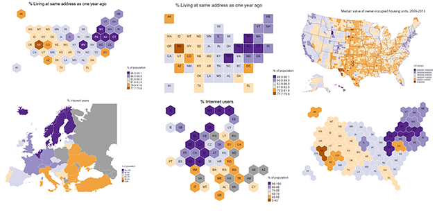
# chorogrid A python script to produce choropleths and colored square- and hex-grid maps
Examples:

There are two classes, Chorobin to assign colors to quantities, and Chorogrid to make the maps.
Maps are made in SVG format; if you need to convert them to PNG you can do so in an external application like Inkscape or Adobe Illustrator, or in python with CairoSVG among other solutions.
Pro tip, because I made this mistake for a long time: it’s “choropleth”, not “chloropleth”; there’s no L. The word comes from ancient Greek χώρα (khṓra, “location”) and πλῆθος (plêthos, “a great number”, same root as plethora), not χλωρός (khlōrós, “pale green”) as in chlorine and chlorophyll. Luckily Google knows enough to suggest the right one.
Release history Release notifications | RSS feed

Download files
Download the file for your platform. If you're not sure which to choose, learn more about installing packages.
Source Distributions
Built Distribution
Filter files by name, interpreter, ABI, and platform.
If you're not sure about the file name format, learn more about wheel file names.
Copy a direct link to the current filters
File details
Details for the file chorogrid-0.0.1-py2.py3-none-any.whl.
File metadata
- Download URL: chorogrid-0.0.1-py2.py3-none-any.whl
- Upload date:
- Size: 2.1 MB
- Tags: Python 2, Python 3
- Uploaded using Trusted Publishing? No
File hashes
| Algorithm | Hash digest | |
|---|---|---|
| SHA256 |
afca76b1d4449247d7fe044f01eaae083f750d0e2595930484c6958ab2138298
|
|
| MD5 |
f4bdbbb57779988f37e2b05baf2250d9
|
|
| BLAKE2b-256 |
2ce140620794e57ea7c39b73d99767f034537b7b7fcc4eae031a6ed5bfee64d1
|


