
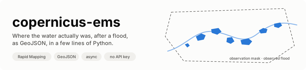




copernicus-ems is a small, typed, async Python library for Copernicus EMS Rapid Mapping, the service that maps floods, fires, landslides and earthquakes from satellite images within hours of a disaster. It reads the activations, their products, and the observed event layers (flooded areas, burnt areas, landslides…) as GeoJSON, together with the observation masks that make them usable as ground truth.
async with RapidMapping() as ems:
    events = await ems.observed_events("EMSR664")  # Emilia-Romagna, May 2023
# 6,334 flood polygons in 11 products, saved in ~/.cache/copernicus-ems/EMSR664/
No account, no API key: the dashboard API is public. One dependency: httpx.
📖 Documentation, API reference and roadmap (AI included): https://agentengineering.it/copernicus-ems/
Contents
- What is Rapid Mapping, in 30 seconds
- What this library does
- Quick start
- Where downloads are saved · Docker
- How it works
- Recipes
- The traps we already fell into
- API at a glance
- Limits
- Contributing
- Data licence and credits
What is Rapid Mapping, in 30 seconds
When a disaster strikes in Europe (or anywhere an authorised user asks),
the Copernicus Emergency Management Service is activated. Each
activation gets a code (EMSR762) and one or more areas of interest
(AOI). Analysts task satellites, and for each AOI they publish products:
a first map, then monitoring updates as the event evolves. Each product
holds vector layers; the one that says where the event actually was
is observedEventA.
flowchart LR
    D["🌊 Disaster"] --> A["Activation<br/>EMSR762"]
    A --> AOI1["AOI01 Brisighella"]
    A --> AOI2["AOI02 Idice"]
    AOI1 --> P1["DEL_PRODUCT<br/>first delineation"]
    AOI1 --> P2["DEL_MONIT01<br/>monitoring update"]
    P1 --> L1["observedEventA<br/>(flooded area)"]
    P1 --> L2["floodDepthA, …"]
    L1 -->|copernicus-ems| G["📁 .geojson on your disk"]
Rapid Mapping is the best open record of where water actually was after a flood in Europe: dated, delineated from satellite images, with an open licence.
What this library does
| Feature | In plain words | |
|---|---|---|
| 🔎 | Activations | Every public activation, filtered by country and category. |
| 🗺️ | Products and observation masks | Each product with its label, the time the satellite saw the event, and the AOI that was looked at. |
| 🌊 | Observed events as GeoJSON | The flooded polygons of each product, filtered to real floods (no landslides, no AOI). |
| 💾 | Disk cache, in a predefined folder | Layers are saved once; a second run reads them from disk. One environment variable moves the folder to a Docker volume. |
| 🔁 | Self-contained | RapidMapping() opens its own HTTP client, retries 502s and network errors, closes it at the end. |
| 🧪 | Pure functions too | Every parsing step is a plain function, if you have your own HTTP stack. |
Why a library, and not the product package
The obvious way to read Rapid Mapping is the expensive and fragile one:
| The obvious way | What this does instead |
|---|---|
download {code}_products.zip (~100 MB per activation, zips of zips, ortho imagery) and read shapefiles |
read each product's vector layer as GeoJSON, the same features |
| some product packages answer 403 (EMSR664, Emilia-Romagna, May 2023) | their GeoJSON layers are open: EMSR664 alone is 6,334 flood polygons |
| take the area of interest as the event | take observedEventA: on EMSR762 AOI01 the AOI is ~1,850 km², the flood 1.19 km² |
filter activations on category Flood |
many Italian floods are filed as Storm: filter features on event_type |
| keep every feature of a flood activation | the same rain's landslides are in it too (6-Mass Movement) |
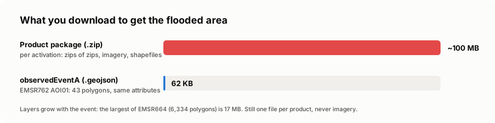
The GeoJSON layers were checked against the shapefiles of the product packages on 77 layers from 10 Italian activations: same features, same attributes, same area.
Who is it for
- Hydrologists and flood modellers who need observed extents to validate a forecast or a hazard map.
- GIS and data engineers who want every flood of a country, repeatably, without clicking through the viewer.
- ML practitioners who need labelled flood / not-flood areas, with the mask that says where "not flooded" was actually observed.
It started inside Limen, where the observed flood extents are the ground truth of a flood backtest, and was extracted so that anyone can use it.
Quick start
1. Install
pip install copernicus-ems
Python 3.12 or newer. No key to create, nothing to configure.
2. Get the floods of an activation
import asyncio

from copernicus_ems import RapidMapping


async def main() -> None:
    async with RapidMapping() as ems:
        italy = await ems.activations(country="Italy", categories=["Flood", "Storm"])
        print(len(italy), "activations in Italy, first", italy[0].code, italy[0].event_time.date())

        events = await ems.observed_events("EMSR664")
        for e in events[:3]:
            print(e.product.label, e.product.observed_time, len(e.features), "polygons")
        print(sum(len(e.features) for e in events), "flood polygons in", len(events), "products")
        print("saved in", ems.directory)


asyncio.run(main())
14 activations in Italy, first EMSR659 2023-05-02
AOI01_DEL_MONIT01 2023-05-18 16:55:00+00:00 462 polygons
AOI01_GRA_PRODUCT 2023-05-22 10:27:00+00:00 92 polygons
AOI01_DEL_PRODUCT 2023-05-17 16:56:00+00:00 1153 polygons
6334 flood polygons in 11 products
saved in /home/you/.cache/copernicus-ems
Run it again: the 11 layers are read from disk and the only request left is the activation detail (12.7 s the first time, 2.1 s the second, on EMSR664).
3. From the command line
The package installs a copernicus-ems command (also python -m copernicus_ems):
copernicus-ems list --country Italy --since 2025-01-01        # code, date, category, name
copernicus-ems list --category Flood --json                   # one JSON object per line
copernicus-ems fetch EMSR762 EMSR664                          # layers into the cache
copernicus-ems export --country Italy -o italy.geojson --masks italy_masks.geojson
copernicus-ems export EMSR762 -o emsr762.geojson --all-events # landslides too
copernicus-ems export EMSR664 -o emsr664.parquet              # GeoParquet ([parquet] extra)
export tags every feature with its activation, product, aoi_name
and observed_time; --masks writes the observation mask of each product
as a second GeoJSON. By country it reads the Flood and Storm
activations (--category to change it), and keeps the flood features.
--dir sets where the layers are saved.
4. Every flood of a country, from Python
examples/italy_floods.py writes one GeoJSON
with every flood polygon of a country, each tagged with its activation,
product and observation time:
uv run python examples/italy_floods.py              # -> italy_floods.geojson
uv run python examples/italy_floods.py Spain spain.geojson
EMSR659 2023-05-02   1195  Flood in Emilia-Romagna, Italy
EMSR664 2023-05-16   6334  Flood in Italy
EMSR705 2023-11-02   1370  Flood in Tuscany region, Italy
...
EMSR871 2026-03-31   1015  Flood in Abruzzo, Molise and Basilicata regions, Italy
15620 polygons from 14 activations; cache: /home/you/.cache/copernicus-ems
Open the result in QGIS or drop it on geojson.io.
Where downloads are saved
The GeoJSON layers are saved in a directory, which is also the cache. If
you don't pass one (RapidMapping(directory=...), or directory= on the
functions):
COPERNICUS_EMS_DATA_DIR, if set;- otherwise
~/.cache/copernicus-ems(or$XDG_CACHE_HOME/copernicus-ems).
$COPERNICUS_EMS_DATA_DIR/
├── EMSR664/
│   ├── EMSR664_AOI01_DEL_PRODUCT_observedEventA_v1.geojson
│   ├── EMSR664_AOI01_DEL_MONIT01_observedEventA_v1.geojson
│   └── …
└── EMSR762/
    └── EMSR762_AOI01_DEL_PRODUCT_observedEventA_v1.geojson
Every flood mapped in Italy since 2023 takes about 200 MB (14 activations, November 2026). Each file is a plain GeoJSON FeatureCollection, exactly as Rapid Mapping publishes it: you can open the folder in QGIS directly.
In Docker
In a container, point the variable at a persistent volume, or the cache is lost with the container and every start downloads everything again:
services:
  app:
    environment:
      COPERNICUS_EMS_DATA_DIR: /data/copernicus-ems
    volumes:
      - ems-data:/data/copernicus-ems   # named volume
      # or a host folder:  - ./data/copernicus-ems:/data/copernicus-ems
volumes:
  ems-data:
With Limen, next to its
other datasets under LIMEN_DATA_ROOT:
    environment:
      COPERNICUS_EMS_DATA_DIR: /var/lib/limen/copernicus-ems
    volumes:
      - ${LIMEN_DATA_ROOT:-../../data}/copernicus-ems:/var/lib/limen/copernicus-ems
The folder is created if missing; the container user must be able to write it.
How it works
The observation mask: why the AOI is not the flood
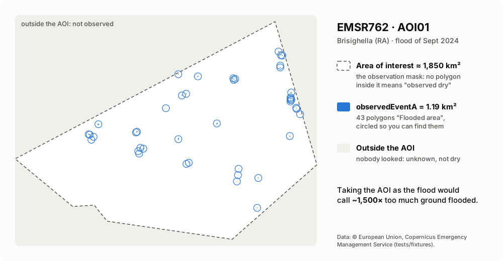
Real data from tests/fixtures/. Each product splits
the map in three:
| Where | What it means | In the library |
|---|---|---|
inside an observedEventA polygon |
observed flooded | ProductEvents.features |
| inside the AOI, no polygon | observed dry | Product.aoi_extent_wkt minus the features |
| outside the AOI | not observed: unknown | — |
So a model that predicted a flood outside every AOI has not raised a false alarm: nobody looked. Inside the AOI and outside the polygons, it has.
Which time to use
An activation has an event_time; each product has an observed_time, the
earliest satellite image it was made from. Use observed_time to say
when the water was seen: anchoring a forecast lead time to event_time
would credit hours in which the flood was already happening.
timeline
    title EMSR664, AOI01 (May 2023)
    16 May : event_time (activation)
    17 May 16:56 : DEL_PRODUCT observed, 1153 polygons
    18 May 16:55 : DEL_MONIT01 observed, 462 polygons
    22 May 10:27 : GRA_PRODUCT observed, 92 polygons
What fetch_layer decides
flowchart TD
    start(["fetch_layer(client, product, kind)"]) --> c0{"product has<br/>a layer of that kind?"}
    c0 -- no --> rn(["return None"])
    c0 -- yes --> c1{".geojson already<br/>in the directory?"}
    c1 -- yes --> r1(["read it from disk<br/>no network"])
    c1 -- no --> g["GET the layer's json URL<br/>(follows the redirect to S3)"]
    g --> v{"valid<br/>FeatureCollection?"}
    v -- no --> e(["raise EmsError<br/>nothing written"])
    v -- yes --> w["write .part, rename to .geojson"]
    w --> r2(["return the collection"])
A layer's file name carries its version (…_observedEventA_v2): when
Rapid Mapping corrects a layer, the new version gets a new file, so a file
in the cache is never stale. The activation list and details are not
cached: new monitoring products appear in them. And because a file is
first written as .part and then renamed, an interrupted run never leaves
a half-written layer behind.
The building blocks
flowchart LR
    subgraph yours["Your code"]
        H["httpx.AsyncClient<br/>(optional)"]
    end
    subgraph lib["copernicus_ems"]
        direction TB
        RM["client.py<br/>RapidMapping · RetryTransport<br/>fetch_* · default_directory"]
        CA["catalogue.py<br/>parse_activations · parse_detail<br/>select_activations"]
        EV["events.py<br/>parse_layer · select_features"]
        ER["errors.py<br/>EmsError"]
    end
    H -.-> RM
    RM --> CA
    RM --> EV
catalogue.py,events.py: pure functions, no network. They build URLs and read answers.client.py: thefetch_*functions wire them to yourhttpx.AsyncClient;RapidMappingbrings its own, with retries.
Products and features
Each Product carries:
label:AOI01_DEL_PRODUCT,AOI02_DEL_MONIT01: delineation (DEL), grading (GRA) or first estimate (FEP), then each monitoring update;observed_time: the earliest satellite image it was made from;aoi_extent_wkt: the observation mask, as WKT (lon/lat);layers: every vector layer by kind (observedEventA,floodDepthA,maximumFloodExtentA, …), the latest version of each.
Features are GeoJSON in CRS84 (lon/lat WGS84), with the Rapid Mapping attributes:
{
  "event_type": "5-Flood",
  "notation": "Flooded area",
  "obj_desc": "Riverine flood",
  "det_method": "Semi-automatic extraction",
  "area": 9.525881
}
select_features keeps 5-Flood with "Flooded area" and "Flood trace" by
default; pass event_types=None, notations=None for everything.
Recipes
Your own HTTP client
Timeouts, proxies, retries stay yours; RapidMapping leaves your client
open:
async with httpx.AsyncClient(timeout=120, proxy="http://proxy:3128") as client:
    ems = RapidMapping(client, directory=Path("data/ems"))
    events = await ems.observed_events("EMSR762")
Or the functions directly, without the class:
from copernicus_ems import fetch_layer, fetch_observed_events, fetch_products

events = await fetch_observed_events(client, "EMSR762", directory=Path("data/ems"))
products = await fetch_products(client, "EMSR762")
depth = await fetch_layer(client, products[0], "floodDepthA")  # None if absent
Other hazards: landslides, everything
landslides = await ems.observed_events("EMSR762", event_types=["6-Mass Movement"], notations=None)
everything = await ems.observed_events("EMSR762", event_types=None, notations=None)
The observation mask as a geometry
import shapely  # pip install shapely
from shapely.geometry import shape

mask = shape(event.product.aoi_extent)  # GeoJSON; or shapely.from_wkt(aoi_extent_wkt)
flooded = shapely.union_all([shape(f["geometry"]) for f in event.features])
observed_dry = mask.difference(flooded)
Areas, label rasters, scores ([geo], [ml] extras)
from copernicus_ems.geo import summary  # pip install 'copernicus-ems[geo]'
from copernicus_ems.ml import evaluate, rasterize  # pip install 'copernicus-ems[ml]'

for s in summary(events):
    print(s.product, f"{s.flooded_km2:.2f} km² flooded of {s.observed_km2:.1f} observed")

labels = rasterize(events[0], resolution_m=20)  # 1 flooded, 0 dry, 255 not observed
scores = evaluate(my_prediction, labels)  # CSI, POD, FAR only inside the AOI
A model that predicts water outside the AOI is not penalised: nobody looked. Details: Geometry & ML.
Open imagery to pair with the labels
copernicus-ems scenes EMSR664 --aoi 1 --optical --max-cloud 30
Products are often made from commercial images (Product.images); this
finds the nearest open Sentinel-1/2 passes over each AOI in the
Copernicus Data Space catalogue, with the time gap and the share of the
AOI they cover. Searching needs no account, downloading does. Details:
Open imagery.
Ask an agent (MCP server, [mcp] extra)
pip install 'copernicus-ems[mcp]'
claude mcp add copernicus-ems -- copernicus-ems mcp
Claude (or any MCP client) gets five tools: list_activations,
activation_summary, compare_products, export_observed_events,
find_scenes. They
answer with computed facts (km², observation times, per AOI) and file
paths, never thousands of polygons. Details:
MCP server.
Handle errors
from copernicus_ems import EmsError

try:
    events = await ems.observed_events("EMSR762")
except EmsError as exc:
    # Rapid Mapping answered, but not with what was asked (HTML, not GeoJSON…)
    print("Rapid Mapping said no:", exc)
except httpx.HTTPError as exc:
    # Network problems and HTTP errors, after the retries of RapidMapping
    print("network:", exc)
Bring your own HTTP (sync example)
No asyncio? Every parsing step is a plain function:
import httpx

from copernicus_ems import detail_url, parse_detail, parse_layer, select_features

with httpx.Client(timeout=60, follow_redirects=True) as http:
    products = parse_detail(http.get(detail_url("EMSR762")).content)
    for product in products:
        if (layer := product.layers.get("observedEventA")) is not None:
            floods = select_features(parse_layer(http.get(layer.url).content))
            print(product.label, len(floods))
The traps we already fell into
The Rapid Mapping viewer is built for clicking. The API behind it works, but the parts that matter are undocumented, and each one fails quietly:
| You try | What actually happens | What copernicus-ems does |
|---|---|---|
the product package (_products.zip) |
~100 MB of zips of zips, and 403 for some activations (EMSR664) | reads the open GeoJSON layers |
| the AOI as the flooded area | ~1,500× too large on EMSR762 AOI01 | reads observedEventA, keeps the AOI as the mask |
category Flood |
many Italian floods are Storm (EMSR928, EMSR930) |
filters features on event_type |
| every feature of a flood activation | the landslides the same rain triggered are in it | keeps 5-Flood by default |
event_time as the time of the observation |
it is when the event started, hours or days before the image | Product.observed_time |
countries from list and detail |
strings in the list, {"name": …} in the detail |
normalises both |
| an older layer version | the API lists every version (_v1, _v2) |
keeps the latest of each kind |
| the dashboard API, many times in a row | 502 now and then | RapidMapping retries with backoff |
API at a glance
| Name | What it does |
|---|---|
RapidMapping(client=None, *, directory=None, retries=3) |
The async client; async context manager. |
.activations(country=, categories=, since=, until=) |
Public activations, oldest first. |
.products(code) |
The products of an activation. |
.layer(product, kind) |
One layer as GeoJSON (cached), or None. |
.observed_events(code, event_types=, notations=, concurrency=4) |
Selected features of each product, layers downloaded in parallel. |
Product.aoi_extent |
The observation mask as a GeoJSON geometry (aoi_extent_wkt as WKT). |
copernicus-ems list / fetch / export |
The command line. |
default_directory() |
Where layers go when no directory is given. |
ENV_DATA_DIR |
"COPERNICUS_EMS_DATA_DIR". |
fetch_activations · fetch_products · fetch_layer · fetch_observed_events |
The same, as functions over your client. |
RetryTransport |
The retrying httpx transport RapidMapping uses. |
EmsError |
The service answered with something that is not what was asked. |
Lower level, for your own HTTP layer: activations_url /
parse_activations / select_activations, detail_url / parse_detail,
parse_layer / select_features, layer_path, parse_time, wkt_to_geojson.
Limits
- The public API lists activations from 2023; older ones live on the legacy site, with no documented API.
- Satellite delineation is a lower bound: short urban floods and water under canopy may not show. A false alarm measured against it may be an event nobody saw.
- Activations are not only European: filter on
country.
Contributing
Contributions of every size are welcome, from a typo to a new feature.
git clone https://github.com/agent-engineering-studio/copernicus-ems
cd copernicus-ems
uv sync          # install everything, dev tools included
make check       # ruff + mypy --strict + pytest, the same gate as CI
The tests do not need the network: they run against recorded answers
of the real API in tests/fixtures/, and write only to
a temporary folder. Because the API is undocumented, a separate set of
contract tests asks the live services the same questions every Monday
(live.yml) and opens an issue if their
answers change shape:
COPERNICUS_EMS_LIVE=1 uv run pytest -m live --no-cov
copernicus-ems/
├── src/copernicus_ems/
│   ├── catalogue.py   # activations, products, layers: pure functions
│   ├── events.py      # GeoJSON layers, feature selection: pure functions
│   ├── client.py      # fetch_*, RapidMapping, cache, retries
│   └── errors.py      # EmsError
├── examples/
│   └── italy_floods.py
├── docs/images/       # the pictures of this README
└── tests/
    └── fixtures/      # real API answers, for offline tests
Rules are short: see CONTRIBUTING.md. Commits follow Conventional Commits, coverage stays above 90%, and contributions are accepted under Apache-2.0.
Ideas to work on
| Idea | Why it matters | Good for |
|---|---|---|
| 🔥 Presets for other hazards (burnt areas, landslides) | Same API, other events | intermediate |
📊 Area statistics and GeoParquet export ([geo] extra) |
Numbers and files for GIS and ML | intermediate |
| 🧪 Fine-tuning notebook on an EO foundation model | Labels + Sentinel-1 → a flood model, scored with evaluate |
advanced |
| 🏛️ Legacy activations (before 2023) | Ten more years of floods | advanced |
Data licence and credits
Rapid Mapping data is © European Union, Copernicus Emergency Management Service, free to use with attribution. Anything you publish from these layers must credit the source, for example:
Contains modified Copernicus Emergency Management Service information, © European Union.
The test fixtures, and the map in this README, are small Rapid Mapping responses under the same terms. The banner is an illustration.
Code: Apache-2.0. Extracted from Limen.
If this project is useful to you, a ⭐ on GitHub helps others find it.
1 maintainer

Metadata
1 maintainer
Release files for copernicus-ems 0.4.0
For a detailed explanation of source distributions (sdists) and built distributions (wheels), please see the package formats documentation.
Source distribution (sdist)
| File | Size | Uploaded | Provenance | Actions |
|---|---|---|---|---|
| copernicus_ems-0.4.0.tar.gz | 51.6 kB | With provenance | Details for copernicus_ems-0.4.0.tar.gz |
Built distribution (wheel)
| File | Interpreter | ABI | Platform | Actions Reset |
|---|---|---|---|---|
| copernicus_ems-0.4.0-py3-none-any.whl | Python 3 | none | any | Details for copernicus_ems-0.4.0-py3-none-any.whl |
Total release size: 100.6 kB
Release files / copernicus_ems-0.4.0.tar.gz
| Download URL | copernicus_ems-0.4.0.tar.gz |
|---|---|
| Size | 51.6 kB |
| Tags | Source |
|
SHA-256 checksum How to use checksums |
c26915ede4883e60b752b28ac56aa5e94a897a22ecb988ca812445c4dd25a986
|
|
BLAKE2b-256 checksum How to use checksums |
4440bfbb86f45696f78c2ec7f93727726c0833fcbeb6148fa6a0582d507827ae
|
| Upload date | |
|
Uploaded using Trusted Publishing? What is trusted publishing? |
Yes |
| Uploaded via |
twine/7.0.0 CPython/3.13.16
|
Provenance
Provenance describes where a file came from. On PyPI, provenance is shared via attestations, which provide a verifiable record of the build or publishing details. View details, limitations and caveats.


PyPI Publish Attestation
PyPI verified that this artifact, at this checksum, originated from the publisher listed below.
Signed by GitHub Actions, verified by PyPI on Nov 4, 2026.
Transparency logRelease files / copernicus_ems-0.4.0-py3-none-any.whl
| Download URL | copernicus_ems-0.4.0-py3-none-any.whl |
|---|---|
| Size | 49.0 kB |
| Tags | Python 3 |
|
SHA-256 checksum How to use checksums |
561d0a3fc5f7881271ef14632d85a435d84a5472fe311856dd6fac318a02a819
|
|
BLAKE2b-256 checksum How to use checksums |
50e059b184f34cbff8e4b33dfcd379111214592630c90ee2e6bc57706050006b
|
| Upload date | |
|
Uploaded using Trusted Publishing? What is trusted publishing? |
Yes |
| Uploaded via |
twine/7.0.0 CPython/3.13.16
|
Provenance
Provenance describes where a file came from. On PyPI, provenance is shared via attestations, which provide a verifiable record of the build or publishing details. View details, limitations and caveats.
PyPI Publish Attestation
PyPI verified that this artifact, at this checksum, originated from the publisher listed below.
Signed by GitHub Actions, verified by PyPI on Nov 4, 2026.
Transparency logSecurity for copernicus-ems 0.4.0
Provenance
Provenance describes where a file came from. On PyPI, provenance is shared via attestations, which provide a verifiable record of the build or publishing details. View details, limitations and caveats.
Full provenance
All 2 files in this release have been uploaded with provenance metadata.
Attestation for copernicus_ems-0.4.0.tar.gz
PyPI Publish Attestation
PyPI verified that this artifact, at this checksum, originated from the publisher listed below.
Signed by GitHub Actions, verified by PyPI on Nov 4, 2026.
Transparency logA note on package security
PyPI is a repository for distributing packages, not a service for auditing them. While third-party security researchers and our staff do their best to detect and remove malicious packages, PyPI cannot guarantee the quality, security or suitability of any given package.
To learn more about protecting yourself from malicious actors, visit our package security documentation.














