A Python package to simplify downloading and processing elevation data.
Verified details
These details have been verified by PyPIProject links
GitHub Statistics
Maintainers

Project description
elevatr
A Python package to simplify downloading and processing elevation data.
Enjoy exploring the heights of the world with elevatr! 🏔️🚀


🌄 Overview
elevatr is a Python library designed for downloading and processing elevation data. It is particularly useful for geospatial analyses and visualizations. The library supports high-resolution raster data and offers easy-to-use tools for displaying and exporting elevation information. 🗺️📊
📦 Installation
To install elevatr, run the following command:
pip install elevatr
🛠️ How To Use
📥 Download Elevation Data
Here is a simple example of how to use elevatr to download elevation data:
import elevatr as elv

# Define the bounding box of the area of interest (min_lon, min_lat, max_lon, max_lat)
bbx = (-5.14, 41.33, 9.56, 51.09)

# Set the level of precision (between 0 and 14)
zoom = 6

# Access the elevation data
raster = elv.get_elev_raster(locations=bbx, zoom=zoom)
📝 Note: Please choose the zoom level incrementally, a high level of zoom on a large area can take a lot of time and memory.
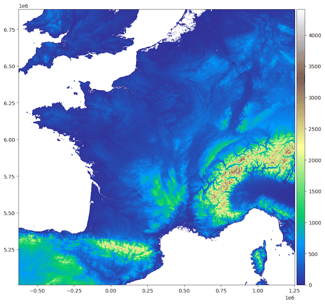
🖼️ Display the elevation data:
raster.show(cmap='terrain', clip_zero=True)
🌍 Example output:
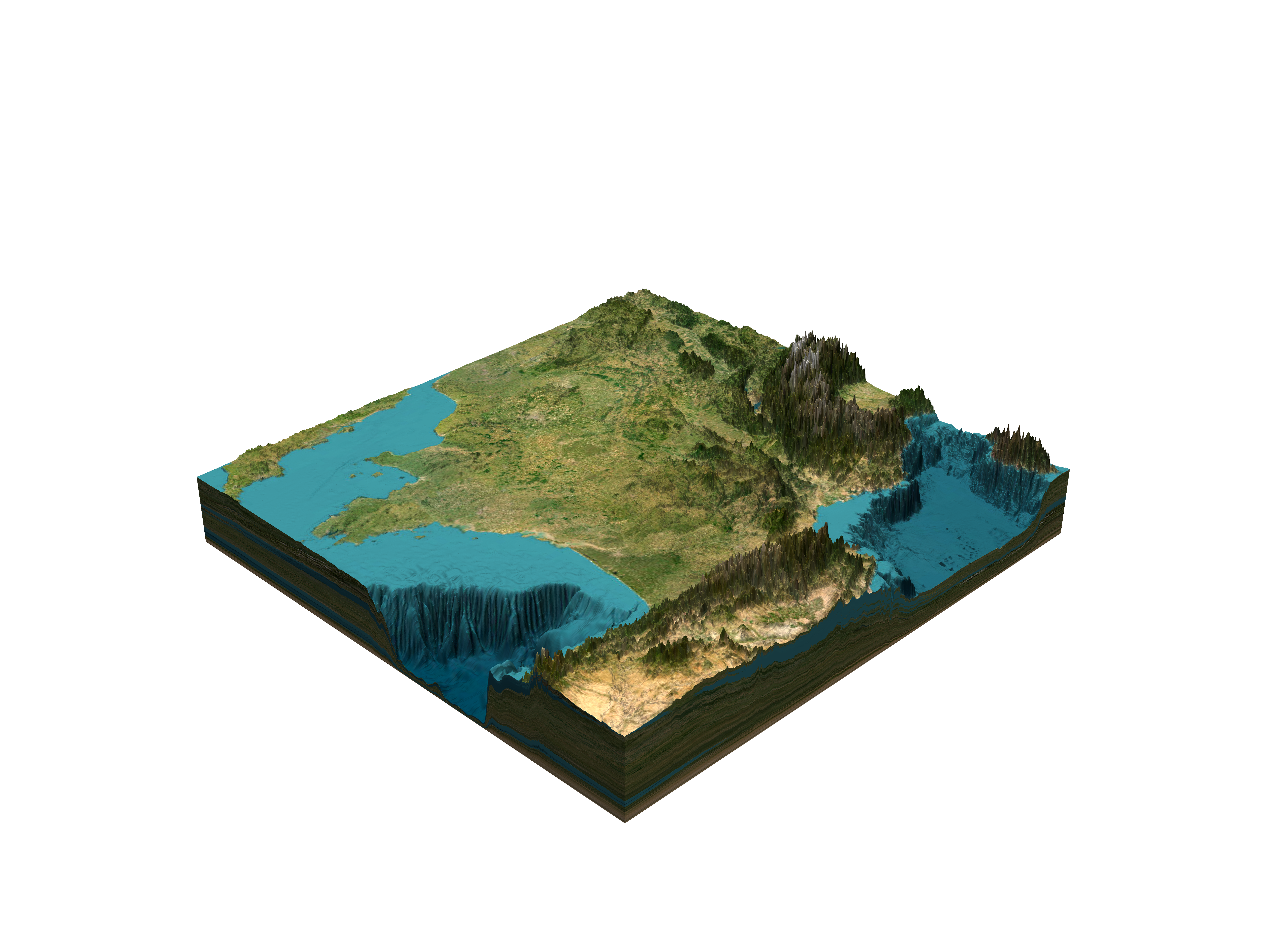
🏔️ Visualize in 3D
raster.show_3d(
    solid=True,
    light_intensity=0.5,
    transparent_background=True,
    zscale=40,
    phi=30,
    theta=180,
    file_path="elevation.png",
)
Render a stunning 3D view of your elevation data! 🌐✨
🌍 Example output:
💾 Save to TIFF File
raster.to_tif("elevation.tif")
Save your elevation data to a TIFF file for further use! 🗂️✨
🌐 Data Sources
List of Sources
The underlying data sources are a mix of:
- 3DEP: Formerly NED and NED Topobathy in the United States, 10 meters outside of Alaska, 3 meters in select land and territorial water areas.
- ArcticDEM: Strips of 5 meter mosaics across all of the land north of 60° latitude, including Alaska, Canada, Greenland, Iceland, Norway, Russia, and Sweden.
- CDEM: Canadian Digital Elevation Model in Canada, with variable spatial resolution (from 20-400 meters) depending on the latitude.
- data.gov.uk: 2 meters over most of the United Kingdom.
- data.gv.at: 10 meters over Austria.
- ETOPO1: For ocean bathymetry, 1 arc-minute resolution globally.
- EUDEM: In most of Europe at 30 meter resolution, including Albania, Austria, Belgium, Bosnia and Herzegovina, Bulgaria, Croatia, Cyprus, Czechia, Denmark, Estonia, Finland, France, Germany, Greece, Hungary, Iceland, Ireland, Italy, Kosovo, Latvia, Liechtenstein, Lithuania, Luxembourg, Macedonia, Malta, Montenegro, Netherlands, Norway, Poland, Portugal, Romania, Serbia, Slovakia, Slovenia, Spain, Sweden, Switzerland, and United Kingdom.
- Geoscience Australia's DEM of Australia: 5 meters around coastal regions in South Australia, Victoria, and Northern Territory.
- GMTED: Globally, coarser resolutions at 7.5", 15", and 30" in land areas.
- INEGI: Continental relief in Mexico.
- Kartverket: Digital Terrain Model, 10 meters over Norway.
- LINZ: 8 meters over New Zealand.
- SRTM: Globally except high latitudes, 30 meters (90 meters nominal quality) in land areas.
Data Sources per Zoom Level
| Zoom | Ocean | Land |
|---|---|---|
| 0 | ETOPO1 |
ETOPO1 |
| 1 | ETOPO1 |
ETOPO1 |
| 2 | ETOPO1 |
ETOPO1 |
| 3 | ETOPO1 |
ETOPO1 |
| 4 | ETOPO1 |
GMTED |
| 5 | ETOPO1 |
GMTED |
| 6 | ETOPO1 |
GMTED |
| 7 | ETOPO1 |
SRTM, NRCAN in Canada, with GMTED in high latitudes above 60° |
| 8 | ETOPO1 |
SRTM, NRCAN in Canada, with GMTED in high latitudes above 60° |
| 9 | ETOPO1 |
SRTM, NRCAN in Canada, EUDEM in Europe, with GMTED in high latitudes above 60° |
| 10 | ETOPO1, NED Topobathy in California |
SRTM, data.gov.at in Austria, NRCAN in Canada, SRTM, NED/3DEP 1/3 arcsec, data.gov.uk in United Kingdom, INEGI in Mexico, ArcticDEM in latitudes above 60°, LINZ in New Zealand, Kartverket in Norway |
| 11 | ETOPO1, NED Topobathy in California |
SRTM, data.gov.at in Austria, NRCAN in Canada, SRTM, NED/3DEP 1/3 arcsec and 1/9 arcsec, data.gov.uk in United Kingdom, INEGI in Mexico, ArcticDEM in latitudes above 60°, LINZ in New Zealand, Kartverket in Norway |
| 12 | ETOPO1, NED Topobathy in California |
SRTM, data.gov.at in Austria, NRCAN in Canada, SRTM, NED/3DEP 1/3 arcsec and 1/9 arcsec, data.gov.uk in United Kingdom, INEGI in Mexico, ArcticDEM in latitudes above 60°, LINZ in New Zealand, Kartverket in Norway |
| 13 | ETOPO1, NED Topobathy in California |
SRTM, data.gov.at in Austria, NRCAN in Canada, SRTM, NED/3DEP 1/3 arcsec and 1/9 arcsec, data.gov.uk in United Kingdom, INEGI in Mexico, ArcticDEM in latitudes above 60°, LINZ in New Zealand, Kartverket in Norway |
| 14 | ETOPO1, NED Topobathy in California |
SRTM, data.gov.at in Austria, NRCAN in Canada, SRTM, NED/3DEP 1/3 arcsec and 1/9 arcsec, data.gov.uk in United Kingdom, INEGI in Mexico, ArcticDEM in latitudes above 60°, LINZ in New Zealand, Kartverket in Norway |
| 15 | ETOPO1, NED Topobathy in California |
SRTM, data.gov.at in Austria, NRCAN in Canada, SRTM, NED/3DEP 1/3 arcsec and 1/9 arcsec, data.gov.uk in United Kingdom, INEGI in Mexico, ArcticDEM in latitudes above 60°, LINZ in New Zealand, Kartverket in Norway |
📝 Note: Information about data sources is provided here.
⚖️ License
Elevatr is licensed under the MIT License. This means you are free to use, modify, and distribute this software. However, the software is provided “as is”, without warranty of any kind.
🙏 Acknowledgments
This package is inspired by the great elevatr package for the R language. It was this package that inspired me to create a similar package to ease access to this data for Python users.
GitHub @titouanlegourrierec · Email titouanlegourrierec@icloud.com
Project details
Verified details
These details have been verified by PyPIProject links
GitHub Statistics
Maintainers
Release history Release notifications | RSS feed


Download files
Download the file for your platform. If you're not sure which to choose, learn more about installing packages.
Source Distribution
Built Distribution
Filter files by name, interpreter, ABI, and platform.
If you're not sure about the file name format, learn more about wheel file names.
Copy a direct link to the current filters
File details
Details for the file elevatr-0.5.0.tar.gz.
File metadata
- Download URL: elevatr-0.5.0.tar.gz
- Upload date:
- Size: 19.1 kB
- Tags: Source
- Uploaded using Trusted Publishing? Yes
- Uploaded via: uv/0.10.9 {"installer":{"name":"uv","version":"0.10.9","subcommand":["publish"]},"python":null,"implementation":{"name":null,"version":null},"distro":{"name":"Ubuntu","version":"24.04","id":"noble","libc":null},"system":{"name":null,"release":null},"cpu":null,"openssl_version":null,"setuptools_version":null,"rustc_version":null,"ci":true}
File hashes
| Algorithm | Hash digest | |
|---|---|---|
| SHA256 |
9222150a111d21ece00ab83e32817fb59d8d1e898ebbc09849a1ac945dfe9013
|
|
| MD5 |
84ccf591fa6f6df76fb8b4a78dadb79c
|
|
| BLAKE2b-256 |
56d2bdc69e3bec009d4bbd58d9cae57e27e401a4536877f409c92259813fb852
|
File details
Details for the file elevatr-0.5.0-py3-none-any.whl.
File metadata
- Download URL: elevatr-0.5.0-py3-none-any.whl
- Upload date:
- Size: 21.2 kB
- Tags: Python 3
- Uploaded using Trusted Publishing? Yes
- Uploaded via: uv/0.10.9 {"installer":{"name":"uv","version":"0.10.9","subcommand":["publish"]},"python":null,"implementation":{"name":null,"version":null},"distro":{"name":"Ubuntu","version":"24.04","id":"noble","libc":null},"system":{"name":null,"release":null},"cpu":null,"openssl_version":null,"setuptools_version":null,"rustc_version":null,"ci":true}
File hashes
| Algorithm | Hash digest | |
|---|---|---|
| SHA256 |
0db7f0f39330765c7e5da2223ad557c90bd412a63f5f4a38d8c2c590fc98143f
|
|
| MD5 |
88058b471b1903b035b5458b5e40f98f
|
|
| BLAKE2b-256 |
de3028e704cc90e780707c93ee7aa1f7bf60b8d0b92e109da38a142e77168fe4
|


