





firms-client is a small, typed, async Python library for NASA FIRMS, the Fire Information for Resource Management System: every active fire seen from space since 2000. It downloads the open per-country archives (no account, no key), queries the near-real-time area API, and does the parsing that tells a vegetation fire from a steelworks.
rows = await fetch_archive(client, VIIRS_SNPP, 2025, "Italy")  # 23,349 detections, no key
fires = select(rows)  # 14,880 vegetation fires
One dependency: httpx. Website: agentengineering.it/firms-client, with the roadmap.
Contents
- What is FIRMS, in 30 seconds
- What this library does
- Who is it for
- Quick start
- Where downloads are saved
- Not every hotspot is a fire
- How it works
- Recipes
- The traps we already fell into
- API at a glance
- Contributing · Ideas to work on
- Data licence and credits
What is FIRMS, in 30 seconds
Several satellites look at the whole Earth a few times a day with thermal infrared sensors. When a pixel is much hotter than its surroundings, it is reported as a hotspot: a point with a position, a time, a brightness temperature, a fire radiative power (FRP, in MW) and a confidence. NASA collects them in FIRMS, a few hours after the overpass.
flowchart LR
    S["🛰️ MODIS (Terra, Aqua)<br/>🛰️ VIIRS (S-NPP, NOAA-20, NOAA-21)"] --> F["NASA LANCE / FIRMS<br/>hotspot detection"]
    F --> A["📦 Per-country yearly CSVs<br/>open, 2000 →"]
    F --> N["⚡ Area API<br/>1-5 days per query, MAP_KEY"]
    A -->|fetch_archive| C["firms-client<br/>parse · classify · select"]
    N -->|fetch_area| C
    C --> U["Your analysis<br/>fire history · risk models · alerts"]
What people use it for:
- a fire history of a country or region, year by year, for 26 years;
- a wildfire trigger: something is burning in my area right now;
- training data for fire-risk and burnt-area models;
- air-quality and emissions work, from the radiative power of each fire.
What this library does
| Feature | In plain words | |
|---|---|---|
| 📦 | Open yearly archives | MODIS from 2000 and VIIRS S-NPP from 2012, per country, with no Earthdata login and no key. |
| 💾 | Never download twice | Archives are saved in a persistent data directory and read from disk next time. |
| ⚡ | Near-real-time area API | The last days over any bounding box, with a free MAP_KEY. |
| 🔥 | Fire or factory? | Every detection carries its FIRMS type: vegetation, volcano, industry, offshore. |
| 🎚️ | One confidence scale | MODIS percentages and VIIRS l/n/h (or low/nominal/high) judged by one rule. |
| 🛡️ | Errors that look like errors | A missing year is None, a bad key or an error page with HTTP 200 raises FirmsError. |
| 🧪 | Pure functions too | URLs and parsing are plain functions, if you have your own HTTP stack. |
| 🪶 | Light | One dependency (httpx), fully typed (mypy --strict), 100% test coverage. |
Who is it for
- Researchers and students in remote sensing, ecology and climate who want FIRMS data in a notebook or pipeline, without the e-mail order form.
- Data engineers who need a repeatable national fire history.
- Civil protection and risk teams who want a wildfire trigger over their area, with industrial sources already filtered out.
It started inside Limen, which uses the archives as the fire history of Italy and the area API as a wildfire trigger, and was extracted so that anyone can use it.
Quick start
1. Install
pip install firms-client
Python 3.12 or newer.
2. Download a country's year, no key needed
import asyncio
from collections import Counter

import httpx

from firms_client import ARCHIVE_PRODUCTS, fetch_archive, select


async def main() -> None:
    async with httpx.AsyncClient(timeout=120) as client:
        for product in ARCHIVE_PRODUCTS:
            rows = await fetch_archive(client, product, 2025, "Italy")
            if rows is None:  # that year is not published (yet)
                continue
            fires = select(rows)  # vegetation fires, nominal confidence or better
            types = dict(sorted(Counter(r.detection_type for r in rows).items()))
            print(product.slug, len(rows), "detections", types, "->", len(fires), "fires")


asyncio.run(main())
modis 5076 detections {0: 3414, 1: 21, 2: 1635, 3: 6} -> 3315 fires
viirs-snpp 23349 detections {0: 17533, 1: 633, 2: 4277, 3: 906} -> 14880 fires
The CSVs are now in ~/.cache/firms-client/: run it again and nothing is
downloaded. The country is its English name, as FIRMS writes it (Italy,
Greece, United_States…).
3. Or the last days, with a MAP_KEY
The archive runs up to the previous year. For the last days, get a free MAP_KEY (an e-mail address is enough) and ask the area API:
from firms_client import fetch_area, select

ITALY = (6.0, 36.0, 19.0, 47.6)  # west, south, east, north

rows = await fetch_area(client, MAP_KEY, "VIIRS_SNPP_NRT", ITALY, days=3)
fires = select(rows, min_frp_mw=1.0)
days goes from 1 to 5 (the API's limit). Without a date it is the last
days days up to today; on_date=date(2026, 8, 1) asks for the days days
starting on that date. For a longer range, fetch_area_range splits it
into 5-day requests:
from datetime import date

from firms_client import RetryPolicy, fetch_area_range

july = await fetch_area_range(
    client,
    MAP_KEY,
    "VIIRS_SNPP_SP",
    ITALY,
    date(2025, 7, 1),
    date(2025, 7, 31),
    retry=RetryPolicy(),  # 429, 5xx and dropped connections, with backoff
)
The area API is near-real-time and is never cached. Its rows carry no
type, so select() cannot drop industrial sources from them: see
the roadmap.
4. Or from a shell
firms archive Italy 2025                      # a summary, by type
firms archive Italy 2025 --fires --format geojson > fires.geojson
firms archive Greece 2024 --product modis --format csv
FIRMS_MAP_KEY=… firms area --bbox 6,36,19,47.6 --days 3 --fires
FIRMS_MAP_KEY=… firms area --bbox 6,36,19,47.6 --source VIIRS_SNPP_SP --from 2025-07-01 --to 2025-07-31
FIRMS_MAP_KEY=… firms area --bbox 6,36,19,47.6 --days 2 --mask Italy --fires   # without the steelworks
firms anomaly Italy 2017 --month 7
23349 detections
  vegetation fire: 17533
  active volcano: 633
  static land source: 4277
  offshore: 906
from 2025-01-01 to 2025-12-31, busiest day 2025-07-22
FRP: max 420.84 MW, total 148141 MW
The command line retries on 429, 5xx and dropped connections.
5. Or ask an agent: the MCP server
firms-mcp exposes FIRMS as tools over the
Model Context Protocol, for Claude Code,
Claude Desktop or any MCP client:
pip install 'firms-client[mcp]'

# Claude Code
claude mcp add firms -e FIRMS_MAP_KEY=your-key -- firms-mcp
{
  "mcpServers": {
    "firms": {
      "command": "uvx",
      "args": ["--from", "firms-client[mcp]", "firms-mcp"],
      "env": { "FIRMS_MAP_KEY": "your-key" }
    }
  }
}
That is Claude Desktop's claude_desktop_config.json. The MAP_KEY is only
needed for the area API, and stays on the server: the model never sees it.
| Tool | Answers |
|---|---|
fire_history(country, product, first_year, last_year, bbox) |
detections and fires per year, from the open archives |
archive_digest(country, year, product, bbox, top_events) |
one year: by type and month, largest events, hottest cells |
area_digest(bbox, source, days | start+end, top_events, mask_country) |
the area API, last days or any range; with mask_country, without static sources |
season_anomaly(country, year, month, product, bbox, first_year) |
was this year or month unusual? rank, percentile, robust z |
export_geojson(country, year, filename, product, bbox, fires_only) |
a GeoJSON file in FIRMS_EXPORT_DIR (default: exports/ in the data directory) |
Every tool answers with a summarize() digest of a few kilobytes, never raw
rows, so the numbers an agent quotes are computed here. The server's
instructions and the firms://guide resource carry the traps (type,
presence-only, no type in near-real-time data) and firms://attribution
carries the NASA acknowledgement. Ask it "how did the 2021 fire season in
Sicily compare with 2025?": it calls fire_history with Sicily's bbox.
Where downloads are saved
Yearly archives go to the directory you pass (directory= on
fetch_archive, fetch_archive_csv and download_archive). If you pass
none:
FIRMS_DATA_DIR, if set;- otherwise
~/.cache/firms-client(or$XDG_CACHE_HOME/firms-client).
~/.cache/firms-client/
├── modis_2025_Italy.csv          400 KB
├── viirs-snpp_2025_Italy.csv     1.8 MB
└── viirs-snpp_2024_Italy.csv     …
flowchart TD
    Q["fetch_archive(client, VIIRS_SNPP, 2025, 'Italy')"] --> E{"viirs-snpp_2025_Italy.csv<br/>in the data directory?"}
    E -->|yes| R["read from disk<br/>no request"]
    E -->|no| G["GET the yearly CSV"]
    G -->|404| N["None<br/>(not cached: it may be published later)"]
    G -->|200| P["stream to …csv.part"]
    P --> V{"is it a hotspot CSV?"}
    V -->|no| X["delete .part<br/>raise FirmsError"]
    V -->|yes| M["rename to .csv"] --> R
A file that exists is whole: downloads are streamed to a .part file and
renamed only when complete. To refresh a year, delete its file.
In Docker, point it at a volume so the data survives the container:
services:
  app:
    environment:
      FIRMS_DATA_DIR: /data/firms
    volumes:
      - firms-data:/data/firms
volumes:
  firms-data:
It is the same convention as
egms-client
(EGMS_DATA_DIR), so one volume can hold both under /data.
Not every hotspot is a fire
A satellite sees heat, not fire. Steelworks, refineries, gas flares,
volcanoes and offshore platforms are hot every day of the year, and they
come through at high confidence, because they really are hot. FIRMS
labels every detection with a type:
type |
Constant | Meaning |
|---|---|---|
0 |
VEGETATION_FIRE |
presumed vegetation fire |
1 |
ACTIVE_VOLCANO |
active volcano |
2 |
STATIC_LAND_SOURCE |
other static land source: industry, gas flares |
3 |
OFFSHORE |
offshore |
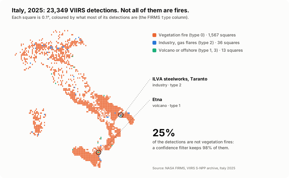
On Italy, about a quarter of the VIIRS detections are not vegetation
fires, and 98% of those pass a nominal-confidence filter. Without
type == 0, the most "burnt" square kilometre in the country over the
whole archive is the ILVA steelworks in Taranto, with 3,308 fire-days.
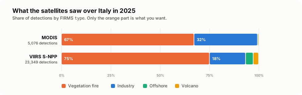
| Italy, 2025 | Detections | Vegetation (0) | Volcano (1) | Industry (2) | Offshore (3) | select() keeps |
|---|---|---|---|---|---|---|
| MODIS | 5,076 | 3,414 | 21 | 1,635 | 6 | 3,315 |
| VIIRS S-NPP | 23,349 | 17,533 | 633 | 4,277 | 906 | 14,880 |
The difference is starkest in winter, when there are few real fires and the factories keep burning:
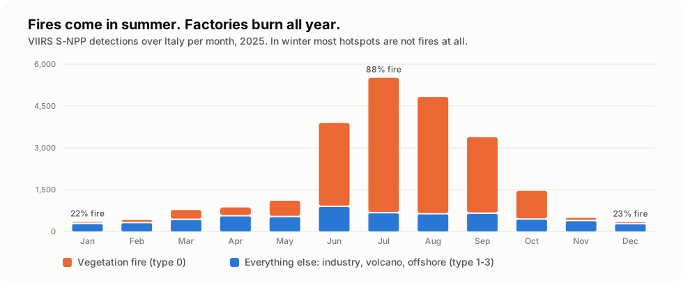
The numbers behind the chart
| VIIRS S-NPP, Italy 2025 | Jan | Feb | Mar | Apr | May | Jun | Jul | Aug | Sep | Oct | Nov | Dec |
|---|---|---|---|---|---|---|---|---|---|---|---|---|
| Vegetation fire | 76 | 117 | 357 | 322 | 590 | 3,018 | 4,859 | 4,214 | 2,751 | 1,034 | 118 | 77 |
| Everything else | 263 | 292 | 411 | 538 | 509 | 875 | 648 | 609 | 628 | 422 | 366 | 255 |
Two things no filter fixes: crop-residue burning is a real vegetation
fire (type 0), and only land cover can set it apart; and FIRMS is
presence-only, so no detection does not mean nothing burnt (clouds,
smoke and the time of the overpass all hide fires).
All the images above are drawn from the real archives by
docs/make_images.py, with this library.
How it works
Two doors in: archives and area API
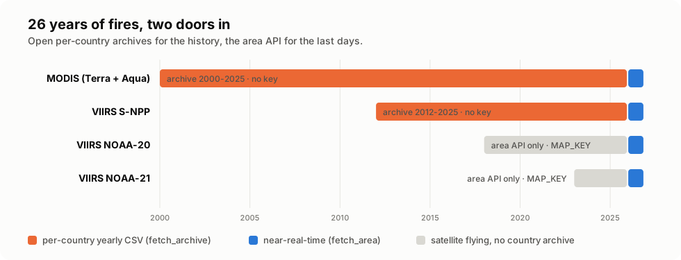
| Per-country archive | Area API | |
|---|---|---|
| Function | fetch_archive, download_archive |
fetch_area |
| What | one country, one whole year | any bounding box, 1-5 days per query |
| Products | MODIS (2000-), VIIRS_SNPP (2012-) |
VIIRS_SNPP_NRT, VIIRS_NOAA20_NRT, VIIRS_NOAA21_NRT, MODIS_NRT (NRT_SOURCES) |
| Key | none | free MAP_KEY |
| Latency | up to the previous year | about 3 hours |
| Processing | standard (SP), with type |
near-real-time |
| Cached on disk | yes | no |
| URL | …/data/country/{product}/{year}/{product}_{year}_{country}.csv |
…/api/area/csv/{key}/{source}/{w,s,e,n}/{days}[/{date}] |
From a CSV row to a Hotspot
MODIS and VIIRS share one layout, with two differences the parser absorbs:
confidence (a percentage for MODIS, a level for VIIRS) and the 4 µm
brightness column (brightness vs bright_ti4). Every row becomes a frozen
dataclass:
| Field | Type | Example | Notes |
|---|---|---|---|
latitude, longitude |
float |
40.52, 17.21 |
degrees, WGS84 |
acq_date |
date |
2025-07-24 |
UTC |
acq_time |
int |
126 |
UTC HHMM: 126 is 01:26 |
confidence |
str | None |
"n", "high", "87" |
as written; see confidence_level |
frp_mw |
float | None |
12.4 |
fire radiative power, MW |
brightness_k |
float | None |
331.2 |
4 µm brightness temperature, K |
daynight |
str | None |
"D" |
day or night overpass |
satellite, instrument |
str | None |
"N", "VIIRS" |
|
detection_type |
int | None |
0 |
the FIRMS type; is_vegetation_fire reads it |
brightness_t5_k |
float | None |
274.9 |
11 µm brightness, K (bright_ti5 / bright_t31) |
scan_km, track_km |
float | None |
0.4, 0.37 |
pixel size along scan and track |
version |
str | None |
"2", "2.0NRT" |
collection and processing |
Rows without coordinates, date or a valid time are skipped.
What select() keeps
flowchart TD
H["Hotspot"] --> T{"vegetation_only and<br/>type is 1, 2 or 3?"}
T -->|yes| D1["❌ dropped<br/>volcano · industry · offshore"]
T -->|"no (type 0, or no type)"| C{"confidence"}
C -->|missing| F
C -->|"VIIRS level"| L{"≥ min_confidence?<br/>(nominal)"}
C -->|"MODIS %"| P{"≥ min_confidence_pct?<br/>else mapped: <30 low,<br/>30-79 nominal, 80+ high"}
L -->|no| D2["❌ dropped"]
P -->|no| D2
L -->|yes| F{"min_frp_mw > 0?"}
P -->|yes| F
F -->|"no"| K["✅ kept"]
F -->|"yes: FRP ≥ min"| K
F -->|"yes: FRP lower or missing"| D3["❌ dropped"]
select(rows, vegetation_only=True, min_confidence="nominal", min_confidence_pct=None, min_frp_mw=0.0):
- a row without
typeis kept, since it cannot be judged; - a missing confidence is kept: losing a real fire is worse than keeping a doubtful pixel;
confidence_level("87")→"high",confidence_level("n")→"nominal": use it to put both instruments on one scale yourself.
What happens on errors
| FIRMS answers | You get |
|---|---|
| archive year not published (404 with a JSON body) | None |
| an error page with HTTP 200 instead of a CSV | FirmsError |
bad MAP_KEY or source (HTTP 400, plain text Invalid MAP_KEY.) |
FirmsError |
| area API, nothing detected (empty body) | [] |
| 5xx, timeouts, network errors | httpx exceptions, untouched, unless you pass retry=RetryPolicy() |
Recipes
The fire history of a country
from firms_client import VIIRS_SNPP, archive_years, fetch_archive, select


async def history(client: httpx.AsyncClient, country: str) -> dict[int, int]:
    """Vegetation fires per year; the first run downloads, the next ones read from disk."""
    per_year = {}
    for year in archive_years(VIIRS_SNPP, until=2025):
        rows = await fetch_archive(client, VIIRS_SNPP, year, country)
        if rows is not None:
            per_year[year] = len(select(rows))
    return per_year
Fire-days per square kilometre
Run it with and without select() to find your country's steelworks:
from collections import defaultdict

days: dict[tuple[float, float], set[date]] = defaultdict(set)
for year in archive_years(VIIRS_SNPP, until=2025):
    for r in await fetch_archive(client, VIIRS_SNPP, year, "Italy") or []:
        days[round(r.latitude, 2), round(r.longitude, 2)].add(r.acq_date)

hottest = sorted(days.items(), key=lambda kv: len(kv[1]), reverse=True)[:5]
for (lat, lon), d in hottest:
    print(f"{lat:.2f}, {lon:.2f}: {len(d)} fire-days")
A monthly chart
With pip install matplotlib:
import matplotlib.pyplot as plt

rows = await fetch_archive(client, VIIRS_SNPP, 2025, "Italy")
fires = [0] * 12
other = [0] * 12
for r in rows:
    (fires if r.is_vegetation_fire is not False else other)[r.acq_date.month - 1] += 1

months = range(1, 13)
plt.bar(months, other, label="industry, volcano, offshore")
plt.bar(months, fires, bottom=other, label="vegetation fire")
plt.legend()
plt.title("VIIRS detections over Italy, 2025")
plt.show()
GeoJSON for QGIS or a web map
import json

from firms_client import to_csv, to_geojson

Path("fires.geojson").write_text(json.dumps(to_geojson(select(rows))))
Path("fires.csv").write_text(to_csv(select(rows)))  # every field, one row per hotspot
Fire events, not pixels
One fire is often dozens of hotspots, seen by several satellites over
several days. cluster links hotspots within radius_m and gap_days of
each other into FireEvents, the largest by total FRP first:
from firms_client import cluster

events = cluster(select(rows), radius_m=750, gap_days=1)  # VIIRS; ~2000 m for MODIS
for e in events[:3]:
    print(e.start, e.days, "days", e.size, "hotspots", f"{e.total_frp_mw:.0f} MW", e.bbox)
On Italy in 2025 the 14,880 VIIRS fires make 8,250 events.
A digest for people and LLMs
summarize does the counting and returns a JSON-ready dict of a few
kilobytes: counts by type, month and day/night, the fires select() keeps,
the largest events, the cells hot on the most days, the caveats and the
NASA attribution. Put it in a prompt instead of 23,000 rows: every number
in it comes from code.
from firms_client import summarize

digest = summarize(rows, top_events=10, top_cells=5)
digest["hot_cells"][0]
# {'latitude': 45.15, 'longitude': 9.94, 'fire_days': 212, 'detections': 430,
#  'not_vegetation_share': 0.991}
From a shell: firms archive Italy 2025 --format json.
Near-real-time data without the steelworks
Area API rows have no type, so select() keeps every steelworks and
volcano. A static-source mask learns from a country's archives where
they are, cell by cell (0.01°), and gives live rows the type of the place
they fall in:
from firms_client import fetch_static_mask

mask = await fetch_static_mask(client, "Italy")  # built once from 2012-last year, then cached
live = await fetch_area(client, MAP_KEY, "VIIRS_NOAA21_NRT", ITALY, days=1)
fires = select(mask.label(live))  # industry, volcanoes and platforms drop out
A cell is static when most of its archive detections are FIRMS type
1-3 (labelled), or when it burned on at least 30 days, in 6 years and
in 8 different months (persistent: a source FIRMS calls vegetation).
mask.verdict(h) says which, with the history behind it, and
label(..., spare_frp_mw=50) keeps strong detections untouched.
How well does it work? The mask was learned on Italy 2012-2024, then the
2025 archive was stripped of its type, as live data are, and labelled
(docs/evaluate_mask.py):
Italy 2025, type hidden |
|
|---|---|
| static detections (FIRMS type 1-3) caught | 99.3% (5,773 / 5,816) |
| of those, with the right type | 97.1% |
| precision | 91.6% |
| FIRMS type 0 masked | 3.0% (530 / 17,533) |
select() without the mask |
20,605 fires, 5,725 of them static |
select() with the mask |
14,430 fires, 42 of them static |
Part of the "type 0 masked" are not mistakes: the Etna lava flow of February 2025, and type-0 detections inside the Taranto steelworks.
Is this season unusual?
season_anomaly puts a year, or a month of it, against every other
archive year: rank, percentile and a robust z-score (median and MAD).
from firms_client import season_anomaly

a = await season_anomaly(client, "Italy", 2017, month=7)
a.describe()  # '2017: 7,552, the highest of 14 years (robust z +3.8)'
From a shell: firms anomaly Italy 2017 --month 7, or
firms anomaly Italy 2021 --bbox 12.3,36.6,15.7,38.35 for Sicily.
Crop burning or wildfire?
type 0 says vegetation, not which: stubble burnt after the harvest and
a forest fire look the same to the satellite. The land cover under an
event tells them apart. With pip install 'firms-client[landcover]',
WorldCover reads ESA WorldCover 10 m
(open data, no account) straight from its public bucket, fetching only the
blocks under the hotspots:
from firms_client import WorldCover, classify_burning, cluster

with WorldCover() as land:
    for event in cluster(select(rows))[:20]:
        verdict = classify_burning(event, land)
        print(event.start, verdict.kind, verdict.reason)
# 2025-08-09 wildfire natural vegetation 100%
# 2025-07-19 crop_burning cropland 92%, natural vegetation 8%, 11 hotspots over 1 day
kind |
When |
|---|---|
wildfire |
natural vegetation (trees, shrubs, grassland, wetland) ≥ 50% |
crop_burning |
cropland ≥ 70%, natural ≤ 15%, at most 15 hotspots over 2 days |
cropland_fire |
the same land, but a larger or longer event |
other |
built-up or bare ground ≥ 50% |
mixed, unknown |
none of the above; no land cover (the sea) |
The thresholds are in BurningRules. It is a heuristic that says what the
map says under the pixels, not a validated classifier.
On Italy 2025 (docs/landcover_italy.py, 129 s
for 400 events read from the bucket):
| VIIRS events, Italy 2025 | wildfire | mixed | crop burning | cropland fire | other |
|---|---|---|---|---|---|
| the 100 largest | 76% | 14% | 9% | 1% | – |
| 300 at random | 48% | 23% | 13% | – | 16% |
Crop burning comes from June to October, after the harvest; the clearest
cases are on the Apulian plain, on 92-96% cropland. One limit shows up
too: the Etna lava flow of February 2025 reads as wildfire, since the map
sees the vegetation on the volcano's flanks. Use the land cover together
with the static-source mask, which catches it.
Reading from the bucket costs about half a second per new 1024-pixel
block: fine for alerts, slow for a country's whole year. For bulk work,
copy the tiles you need and pass their directory: WorldCover(source="…").
Grounded alert bulletins
When the trigger finds a new event, an LLM can draft the few lines an
operator needs, in their language. Code gathers the facts; the model only
writes; every number and place in the draft is then checked against the
facts. With pip install 'firms-client[claude]':
from firms_client import ClaudeWriter, Place, bulletin_facts, draft_bulletin

places = [
    Place("Caltanissetta", 37.4901, 14.0629),
    Place("Enna", 37.5670, 14.2795),
]  # your gazetteer
facts = bulletin_facts(event, places=places, mask=mask, anomaly=season, region="Sicily")
draft = await draft_bulletin(facts, ClaudeWriter(), language="it")

if draft.grounded:
    print(draft.as_text())  # a draft for the operator, never a public alert
else:
    print(draft.problems)  # e.g. ["number '300' is not in the facts", "place 'Corleone' ..."]
bulletin_factshas the event (first and last time seen, peak and total FRP, overpasses, satellites, day and night detections), the nearest places from your gazetteer with distance and direction, the static-source verdict when the mask knows the place, the season's anomaly, and the caveats. The model is never asked where places are.draft_bulletinasks for structured output (BULLETIN_SCHEMA) and runscheck_grounding: numbers must be facts or facts rounded, places must be in the facts. A draft that strays is sent back once with the list of problems; if it still strays,groundedis false andproblemssays why.ClaudeWritercalls Claude Opus 5.5 through the Anthropic API, with refusals retried server-side on Anthropic's recommended fallback (fallbacks="default"). Credentials come from the environment (ANTHROPIC_API_KEY). Any other model works: a writer is just an async(system, facts_json, schema) -> dict.
A wildfire trigger
async def watch(client: httpx.AsyncClient, map_key: str, bbox: BBox) -> None:
    seen: set[tuple[float, float, date, int]] = set()
    while True:
        for source in ("VIIRS_SNPP_NRT", "VIIRS_NOAA20_NRT", "VIIRS_NOAA21_NRT"):
            for h in select(await fetch_area(client, map_key, source, bbox), min_frp_mw=5.0):
                key = (h.latitude, h.longitude, h.acq_date, h.acq_time)
                if key not in seen:
                    seen.add(key)
                    print(f"🔥 {h.latitude:.3f}, {h.longitude:.3f}  {h.frp_mw} MW  {source}")
        await asyncio.sleep(15 * 60)
Bring your own HTTP
archive_url, archive_filename, area_url, is_hotspot_csv and
parse_csv are pure: download with anything, parse with this.
from firms_client import VIIRS_SNPP, archive_url, parse_csv

url = archive_url(VIIRS_SNPP, 2025, "Greece")
rows = parse_csv(requests.get(url, timeout=120).text)
The traps we already fell into
| You might think | What is true |
|---|---|
| the archive needs an Earthdata login and arrives by e-mail | yearly CSVs per country are static and open: no account, no key |
| every satellite has a country archive | modis (2000-) and viirs-snpp (2012-) do; viirs-noaa20 / noaa21 do not |
| high confidence means fire | a steelworks is hot for real and comes through at high confidence |
| a confidence filter is enough | only the type column says what burned: 0 vegetation, 1 volcano, 2 industry, 3 offshore |
| confidence is one format | MODIS writes a 0-100 percentage, VIIRS l/n/h or low/nominal/high |
| a missing year is an empty file | it is a 404 with a JSON body; an error with status 200 is caught too |
| a bad MAP_KEY returns JSON | it is HTTP 400 with plain text Invalid MAP_KEY. |
| the date in the area API ends the window | it starts it: DATE .. DATE + days - 1; without a date, the window ends today |
type 0 is always vegetation |
a lava flow outside the volcano mask is type 0 too: Italy's largest 2025 "vegetation fire" event, 16-21 February, is on the flank of Etna |
| near-real-time rows say what burned | the area API has no type column: a steelworks looks like a fire; use a static-source mask |
| no hotspot means no fire | FIRMS is presence-only: clouds, smoke and the overpass time hide fires |
All checked against the live service on 3 November 2026.
API at a glance
| Name | Kind | What it does |
|---|---|---|
fetch_archive(client, product, year, country, directory=None) |
async | one year of a country, parsed; None if not published |
fetch_archive_csv(…) |
async | the same, as raw CSV text |
download_archive(…) |
async | the CSV's Path in the data directory, downloaded if missing |
fetch_area(client, map_key, source, bbox, *, days=1, on_date=None, retry=None) |
async | detections over a bbox, 1-5 days |
fetch_area_range(client, map_key, source, bbox, start, end, *, retry=None) |
async | any date range, in 5-day requests |
RetryPolicy(attempts=3, backoff_s=1.0, max_backoff_s=30.0, …) |
type | opt-in retries for every fetch (retry=) |
cluster(hotspots, *, radius_m=750.0, gap_days=1) |
pure | hotspots → list[FireEvent], largest first |
summarize(hotspots, *, top_events=10, top_cells=5, …) |
pure | a JSON-ready digest, a few KB, for people and LLMs |
fetch_static_mask(client, country, *, product, first_year, last_year, rules) |
async | the static-source mask of a country, built once and cached |
build_static_mask(hotspots, rules), StaticMask.label/verdict/save/load, MaskRules |
pure | the same from rows you have |
season_anomaly(client, country, year, *, month, bbox, product) |
async | a year or month against the other archive years |
anomaly(series, year) → Anomaly |
pure | the same for any {year: value} series |
bulletin_facts(event, *, places, mask, anomaly, burning, region), Place, nearest_places |
pure | the facts a bulletin may use |
draft_bulletin(facts, writer, *, language, retries) → Bulletin, check_grounding |
async / pure | an LLM draft, checked against the facts |
ClaudeWriter(client=None, *, model="claude-opus-5-5", effort="medium") |
extra [claude] |
a writer on the Anthropic API |
classify_burning(event, land, rules) → BurningVerdict, event_land_cover, BurningRules |
pure | crop burning, wildfire or other, by land cover |
WorldCover(source=…, year=2021) |
extra [landcover] |
ESA WorldCover 10 m, read in place |
to_geojson(hotspots), to_csv(hotspots) |
pure | a GeoJSON FeatureCollection, a CSV of every field |
select(hotspots, *, vegetation_only, min_confidence, min_confidence_pct, min_frp_mw) |
pure | keep what looks like a fire |
parse_csv(text) |
pure | CSV text → list[Hotspot] |
confidence_level(raw) |
pure | MODIS % or VIIRS level → "low" / "nominal" / "high" |
is_hotspot_csv(text) |
pure | is this a hotspot CSV, or an error page? |
archive_url, archive_filename, area_url, area_windows, archive_years |
pure | URLs, file names, 5-day windows, year ranges |
default_directory() |
pure | FIRMS_DATA_DIR, else ~/.cache/firms-client |
MODIS, VIIRS_SNPP, ARCHIVE_PRODUCTS, NRT_SOURCES, SP_SOURCES, MAX_AREA_DAYS |
constants | products and sources |
VEGETATION_FIRE, ACTIVE_VOLCANO, STATIC_LAND_SOURCE, OFFSHORE |
constants | the type values |
Hotspot, FireEvent, ArchiveProduct, BBox, ConfidenceLevel |
types | |
ATTRIBUTION, TYPE_NAMES |
constants | the NASA acknowledgement, names for type |
within(hotspots, bbox) |
pure | the hotspots inside a bbox: one region of a country |
firms_client.mcp_server |
extra [mcp] |
firms-mcp, build_server(), and the tool logic as plain async functions |
FirmsError |
exception | FIRMS answered, but not with a hotspot CSV |
Every async function takes your httpx.AsyncClient: timeouts, proxies,
retries and pooling stay yours.
Contributing
Issues and pull requests are welcome; see CONTRIBUTING.md.
git clone https://github.com/agent-engineering-studio/firms-client
cd firms-client
uv sync
uv sync --all-extras  # the mcp, claude and landcover extras too, for their tests
make check   # ruff, mypy --strict, pytest with coverage: the same gate as CI
Tests never touch the network: they run against small fixtures cut from the 2025 Italian archives.
Ideas to work on
- 🌍 More archives: per-country files for other products, if FIRMS publishes them; a list of the country names FIRMS accepts.
- 🌋 Volcano proximity in the static mask, and masks for more countries,
measured with
docs/evaluate_mask.py. - 📓 Notebooks: a national fire history, a burnt-area comparison.
The full plan, including the AI features (an MCP server, a learned static-source mask for near-real-time data, fire events, grounded alert bulletins), is on the roadmap.
If you use firms-client in a project or a paper, open an issue and tell us: we will link it here.
Data licence and credits
FIRMS data are provided by NASA LANCE / FIRMS and are free to use; please acknowledge "NASA FIRMS" in anything you publish, for example:
We acknowledge the use of data and imagery from LANCE FIRMS operated by NASA's Earth Science Data and Information System (ESDIS) with funding provided by NASA Headquarters.
The test fixtures are a few rows of the 2025 Italian archives, and the images in this README are drawn from the full 2025 archives.
Extracted from Limen. See also egms-client for the ground motion of Europe from Sentinel-1.
License
Code: Apache-2.0.
1 maintainer

Metadata
1 maintainer
Release files for firms-client 0.5.0
For a detailed explanation of source distributions (sdists) and built distributions (wheels), please see the package formats documentation.
Source distribution (sdist)
| File | Size | Uploaded | Provenance | Actions |
|---|---|---|---|---|
| firms_client-0.5.0.tar.gz | 67.0 kB | With provenance | Details for firms_client-0.5.0.tar.gz |
Built distribution (wheel)
| File | Interpreter | ABI | Platform | Actions Reset |
|---|---|---|---|---|
| firms_client-0.5.0-py3-none-any.whl | Python 3 | none | any | Details for firms_client-0.5.0-py3-none-any.whl |
Total release size: 128.6 kB
Release files / firms_client-0.5.0.tar.gz
| Download URL | firms_client-0.5.0.tar.gz |
|---|---|
| Size | 67.0 kB |
| Tags | Source |
|
SHA-256 checksum How to use checksums |
3cf49516ae7fbd1cad9e699b572c2c56648b52a40d5cd0ce5527f154dc0bc0c7
|
|
BLAKE2b-256 checksum How to use checksums |
d53440ae221a45cc83407b0ecc911fdfd13feb7f932588a4c8b0575f889f94e8
|
| Upload date | |
|
Uploaded using Trusted Publishing? What is trusted publishing? |
Yes |
| Uploaded via |
twine/7.0.0 CPython/3.13.16
|
Provenance
Provenance describes where a file came from. On PyPI, provenance is shared via attestations, which provide a verifiable record of the build or publishing details. View details, limitations and caveats.


PyPI Publish Attestation
PyPI verified that this artifact, at this checksum, originated from the publisher listed below.
Signed by GitHub Actions, verified by PyPI on Nov 4, 2026.
Transparency logRelease files / firms_client-0.5.0-py3-none-any.whl
| Download URL | firms_client-0.5.0-py3-none-any.whl |
|---|---|
| Size | 61.6 kB |
| Tags | Python 3 |
|
SHA-256 checksum How to use checksums |
8049ee4ed2298c2686821dbd9578ef300124920f4dc821ac4b9f60050e4fe467
|
|
BLAKE2b-256 checksum How to use checksums |
47a8d72ae1d43d39305733844e39832676bf3348c3e7bdc2d415015afb6ccd03
|
| Upload date | |
|
Uploaded using Trusted Publishing? What is trusted publishing? |
Yes |
| Uploaded via |
twine/7.0.0 CPython/3.13.16
|
Provenance
Provenance describes where a file came from. On PyPI, provenance is shared via attestations, which provide a verifiable record of the build or publishing details. View details, limitations and caveats.
PyPI Publish Attestation
PyPI verified that this artifact, at this checksum, originated from the publisher listed below.
Signed by GitHub Actions, verified by PyPI on Nov 4, 2026.
Transparency logSecurity for firms-client 0.5.0
Provenance
Provenance describes where a file came from. On PyPI, provenance is shared via attestations, which provide a verifiable record of the build or publishing details. View details, limitations and caveats.
Full provenance
All 2 files in this release have been uploaded with provenance metadata.
Attestation for firms_client-0.5.0.tar.gz
PyPI Publish Attestation
PyPI verified that this artifact, at this checksum, originated from the publisher listed below.
Signed by GitHub Actions, verified by PyPI on Nov 4, 2026.
Transparency logA note on package security
PyPI is a repository for distributing packages, not a service for auditing them. While third-party security researchers and our staff do their best to detect and remove malicious packages, PyPI cannot guarantee the quality, security or suitability of any given package.
To learn more about protecting yourself from malicious actors, visit our package security documentation.














