
A clean, validated Python library for the complete onshore geotechnical workflow — lab tests, site investigation, design, dynamics, and data exchange.

Project description

GeoEq
Geotechnical engineering, solved in Python.
A clean, validated, MIT-licensed library for the complete onshore geotechnical workflow — laboratory characterisation, site investigation, engineering design, soil dynamics, and data exchange — under a single flat namespace.







Install · Quick start · Capabilities · Website · Guide
The problem
Geotechnical analysis still runs on spreadsheets. One tab per soil layer, copy-pasted Boussinesq equations, magic-number unit conversions, =IF() ladders nobody else can read six months later. Reports are non-reproducible. Calculations get re-done from scratch every project. New engineers re-derive Terzaghi every time they touch a footing.
The solution
geoeq is one flat, validated Python library covering the full onshore geotechnical workflow — lab tests through site investigation through design through dynamics — in 170+ functions under a single import. Plain dictionaries in, plain dictionaries out. Every formula cites its textbook source. Every function is validated against published values.
import geoeq as ge

ge.density(Gs=2.65, e=0.72, kind="saturated", unit="kN/m3")           # 19.6 kN/m^3
ge.spt_friction_angle(N=15, sigma_v=80, method="hatanaka")            # 33.2 deg
ge.bearing_capacity(c=10, gamma=18, Df=1, B=2, phi=30, method="meyerhof")
ge.liquefaction_fos(CSR=0.20, CRR=0.18, Mw=7.0)                       # {'FS': 0.95, ...}
Installation
pip install geoeq
Python 3.9+ on any platform. Dependencies: numpy, matplotlib, scipy — nothing else.
import geoeq as ge
After import, every public function is a top-level attribute of ge. You never need to remember which submodule a function lives in.
Quick start
A complete end-to-end screen of a multi-layer site, in fifteen lines.
import geoeq as ge

# 1. Define a layered profile with a water table
p = ge.SoilProfile([
    (0, 2,  ge.Soil("Fill",       gamma=18)),
    (2, 8,  ge.Soil("Soft Clay",  gamma=17, gamma_sat=18.5,
                                  phi=0, c=25, Cc=0.27, e=0.92)),
    (8, 20, ge.Soil("Dense Sand", gamma=19, gamma_sat=20.5, phi=35)),
], water_table=2.0)

print(p.stress_at(10))
# {'sigma': 188.0, 'u': 78.48, 'sigma_eff': 109.52}

# 2. Bearing capacity of a 3 m square footing
bc = ge.bearing_capacity(c=25, gamma=18.5 - 9.81, Df=2, B=3, L=3,
                         phi=0, method="meyerhof")
print(f"q_u = {bc['q_u']:.0f} kPa")    # q_u = 192 kPa

# 3. Liquefaction triggering check (NCEER simplified procedure)
csr = ge.liquefaction_csr(amax=0.25, sigma_v=120, sigma_v_eff=70, z=6, Mw=7.0)
crr = ge.liquefaction_crr(N160cs=12, method="youd_2001")
fs  = ge.liquefaction_fos(csr["CSR"], crr["CRR"], Mw=7.0)
print(fs)
# {'FS': 0.58, 'liquefies': True, ...}
Capabilities
A working summary of what ships in v0.1.0. The complete per-function reference lives in the handbook and the online guide.
Soil properties and classification
| Function | Description |
|---|---|
ge.void_ratio() · ge.porosity() · ge.specific_gravity() |
Phase volumetrics |
ge.density() |
One function — dry / saturated / bulk / submerged, in kN/m³ or pcf |
ge.saturation() · ge.water_content() |
Phase relations |
ge.relative_density() |
Dr from void ratio or dry density limits |
ge.atterberg() · ge.activity() · ge.sensitivity() · ge.liquidity_index() |
Index correlations |
ge.classify_uscs() · ge.classify_aashto() · ge.plasticity_chart() |
ASTM D2487 · AASHTO M145 |
Laboratory testing
| Suite | Functions |
|---|---|
| Particle size | sieve_ana · hydro_ana · grain_size_plot · grain_d10/d30/d60 · grain_Cu · grain_Cc |
| Shear strength | direct_shear · triaxial · unconfined · mohr_circle |
| Consolidation | oedometer · preconsolidation · compression_index · cv (root + log time) |
| Compaction | proctor · zav_line · saturation_line · relative_compaction |
| Permeability | constant_head · falling_head |
| Atterberg test | liquid_limit_test · flow_curve_plot |
| CBR | cbr_test · cbr_plot |
Site investigation
| Suite | Functions |
|---|---|
| SPT | spt_n60 · spt_n160 (3 methods) · spt_n160cs · spt_friction_angle (3) · spt_su (2) · spt_dr (3) · spt_modulus (6 soils) |
| CPT | cpt_normalize · cpt_ic · cpt_sbt (Robertson) · cpt_friction_angle · cpt_su · cpt_dr · cpt_modulus · cpt_sbt_plot |
| Field vane | vane_su · vane_correction (Bjerrum) · vane_remolded |
| Pressuremeter | pmt_parameters · pmt_modulus · pmt_su · pmt_bearing · pmt_settlement · pmt_ko |
| Plate load | plt_bearing (3 criteria) · plt_subgrade_modulus · plt_settlement_correction · plt_elastic_modulus |
| Pile load tests | davisson · chin · de_beer · hansen_80 · fhwa_5_percent · case_method · hiley · danish_formula · enr |
| Field permeability | slug_test (Hvorslev) · pumping_test_confined · pumping_test_unconfined (Thiem) · lefranc_test |
| Field CBR / DCP | dcp_cbr (Webster · TRL · Kleyn) · field_cbr_test |
Engineering design
| Suite | Functions |
|---|---|
| Effective stress | total_stress · pore_pressure · effective_stress · capillary_rise · stress_plot |
| Seepage | darcy_flow · hydraulic_gradient · critical_gradient · equivalent_k · flow_net |
| Stress distribution | boussinesq_point/line/strip/circular/rect · westergaard_point · newmark_influence · stress_2to1 · stress_isobar_plot |
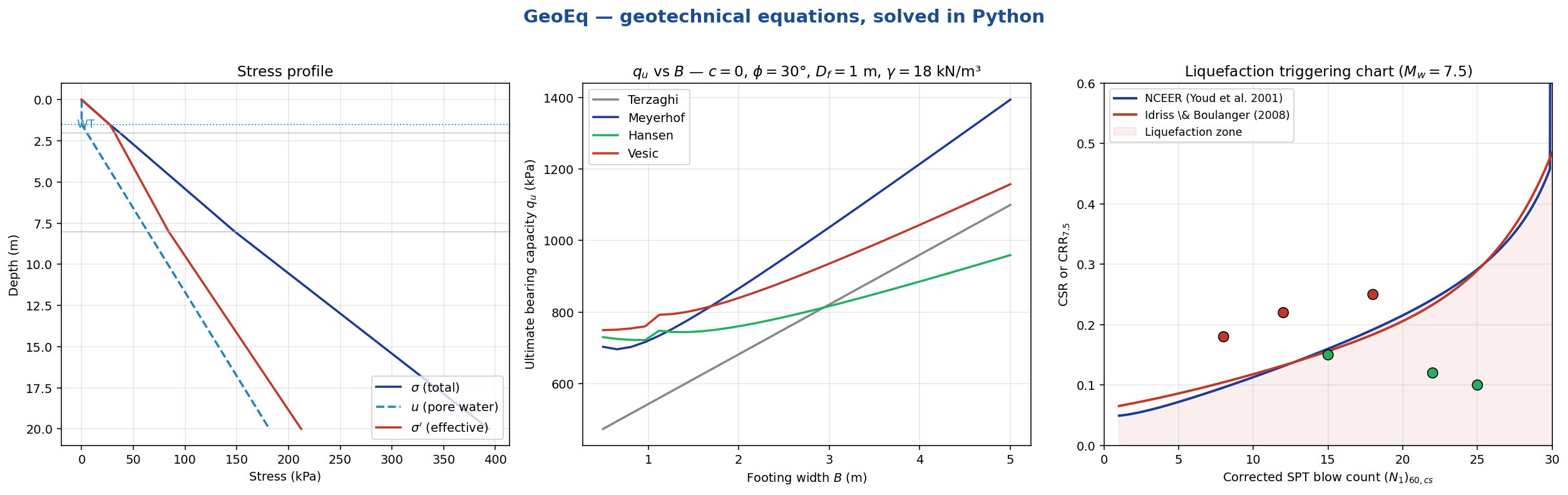
| Bearing capacity | Terzaghi · Meyerhof · Hansen · Vesic — shape, depth, inclination factors · bearing_capacity_plot |
| Settlement | settlement_immediate (Janbu) · settlement_primary (NC/OC/crossing) · settlement_secondary · settlement_schmertmann (1978) · time_factor ↔ consolidation_degree · settlement_time_plot |
| Earth pressure | K0 (Jaky · Mayne-Kulhawy) · Ka / Kp (Rankine · Coulomb) · earth_pressure · tension_crack_depth · earth_pressure_plot |
| Retaining walls | wall_overturning · wall_sliding · wall_bearing (kern check) · sheet_pile (Blum) |
| Pile design | pile_end_bearing (Meyerhof · Vesic · Skempton) · pile_skin_friction (alpha · beta · lambda) · pile_capacity · pile_group_efficiency · pile_settlement (Vesic) |
| Slope stability | infinite_slope (with seepage) · culmann · taylor_stability · bishop (iterative) · taylor_chart_plot |
Soil dynamics
| Function | Description |
|---|---|
gmax() · gmax_hardin() |
Gmax from Vs or Hardin & Black (1968) |
modulus_reduction() |
G/Gmax — Darendeli (2001), Vucetic-Dobry (1991) |
damping_ratio() |
Equivalent-linear damping (Darendeli + Hardin-Drnevich) |
depth_reduction() |
rd from Idriss (1999), Liao-Whitman (1986), Cetin et al. (2004) |
liquefaction_csr() |
Seed-Idriss (1971) cyclic stress ratio |
liquefaction_crr() |
CRR — Youd et al. (2001), Idriss-Boulanger (2008) SPT/CPT, Andrus-Stokoe (2000) Vs |
magnitude_scaling_factor() |
Idriss · NCEER · Boulanger-Idriss (2014) |
liquefaction_fos() |
FSL = CRR · MSF · Kσ · Kα / CSR |
gmax_curves_plot() · liquefaction_chart() |
Publication-quality charts |
Layered ground model
clay = ge.Soil("Soft Clay", gamma=17, gamma_sat=18.5, phi=0, c=25, e=0.9)

p = ge.SoilProfile([
    (0, 2,  ge.Soil("Fill",       gamma=18)),
    (2, 8,  clay),
    (8, 20, ge.Soil("Dense Sand", gamma=19, gamma_sat=20.5, phi=35)),
], water_table=1.5)

p.effective_stress(10)   # σ' at z = 10 m
p.plot()                 # publication-quality stress profile
Data I/O
| Function | Description |
|---|---|
read_csv() |
Geotech CSV with auto-header and units-row detection |
read_ags() |
AGS4 format (UK / Australia / NZ ground-investigation standard) |
read_gef() |
GEF-CPT format (Dutch standard) |
CPT() · .from_gef() · .from_ags() |
CPT container class |
Design principles
- Flat API.
import geoeq as ge, then call functions. No deep import chains, no class hierarchies. - Validated inputs. Every function checks physical meaningfulness (porosity ≤ 1, saturation ≤ 1, etc.) with engineer-readable errors.
- Traceable formulas. Every docstring cites the textbook section or original paper. No mystery constants.
- No magic. Plain
dictreturns, Matplotlib figures. Inspect, slice, feed into Pandas, do whatever you would do with NumPy output. - Test-backed. 563 tests across 170+ functions, all passing. Textbook values are spot-checked: Fadum I5(1,1) = 0.1752; Meyerhof N-factors at φ = 30°; Boussinesq circular at z = R; Rankine Ka / Kp; Hardin & Drnevich plasticity exponent k.
- Publication quality. 300 DPI figures, semi-log axes, shaded ASTM particle zones, red-dashed Dx projection lines out of the box.
- MIT forever. Commercial consulting, in-house tools, research, teaching. No exceptions, no dual licensing.
Running the tests
git clone https://github.com/geoeq/geoeq.git
cd geoeq
pip install -e ".[dev]"
pytest                       # -> 563 passed
Contributing
The repository is open for issue reports and feedback. Pull requests are welcome once the project reaches v1.0; until then, please open an issue first to discuss any proposed change.
- Found a formula bug or a unit mistake? Open an issue with a textbook citation.
- Want a function prioritised? Open an issue tagged
enhancementdescribing the use case. - Using GeoEq in coursework or research? Open an issue tagged
usage— we would like to hear about real-world uses.
Citation
If you use GeoEq in academic work, please cite:
@software{geoeq2026,
  author       = {Malo, Ripon Chandra},
  title        = {GeoEq: A Python Library for Geotechnical Engineering},
  year         = {2026},
  version      = {0.1.0},
  url          = {https://github.com/geoeq/geoeq},
  license      = {MIT}
}
License
MIT — free for personal, commercial, consulting, and enterprise use forever. See LICENSE.
Copyright © 2026 Ripon Chandra Malo · University of Utah
If GeoEq saved you a spreadsheet, please star the repository — it is the cheapest way to help.


Download files
Download the file for your platform. If you're not sure which to choose, learn more about installing packages.
Source Distribution
Built Distribution
Filter files by name, interpreter, ABI, and platform.
If you're not sure about the file name format, learn more about wheel file names.
Copy a direct link to the current filters
File details
Details for the file geoeq-0.1.2.tar.gz.
File metadata
- Download URL: geoeq-0.1.2.tar.gz
- Upload date:
- Size: 126.2 kB
- Tags: Source
- Uploaded using Trusted Publishing? No
- Uploaded via: twine/6.2.0 CPython/3.9.18
File hashes
| Algorithm | Hash digest | |
|---|---|---|
| SHA256 |
150dc4df08e273e4784c224e53074b38fd47ba8d0ba9aa16595e4ac2138ae560
|
|
| MD5 |
3c8ba7369efb6ff8561da284ad3aba5f
|
|
| BLAKE2b-256 |
47fa077e92193410db2a311b38dad8348c561c182da72f74747c20dd67b70015
|
File details
Details for the file geoeq-0.1.2-py3-none-any.whl.
File metadata
- Download URL: geoeq-0.1.2-py3-none-any.whl
- Upload date:
- Size: 135.2 kB
- Tags: Python 3
- Uploaded using Trusted Publishing? No
- Uploaded via: twine/6.2.0 CPython/3.9.18
File hashes
| Algorithm | Hash digest | |
|---|---|---|
| SHA256 |
35e3912d9ecfac20648c61415dfb34b5fd29c144eb07697ccc58fc63cf7bd640
|
|
| MD5 |
3487a077905695d8baad994ef2d025ba
|
|
| BLAKE2b-256 |
b7674bcd880b5fc24820680406c70c98b36a06119089ced1a9b8680182a89265
|






