A simple tool to iterate circles within given boundaries:

Project description
geoiter
iterates the planet.
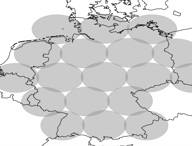
A simple tool to iterate coordinates within given boundaries. The usage is mostly for querying/searching by location. Geoiter provides many locations within a boundary, like a country. Let's say Germany has in sum 5000 houses to sell. Then most platforms will only allow you to visit the first 200 houses. Now to get the others, you need to dissect the big boundary area into smaller ones. And this is where geoiter provides you with coordinates
geoiter can be used for web scraping to utilize geo/location queries:
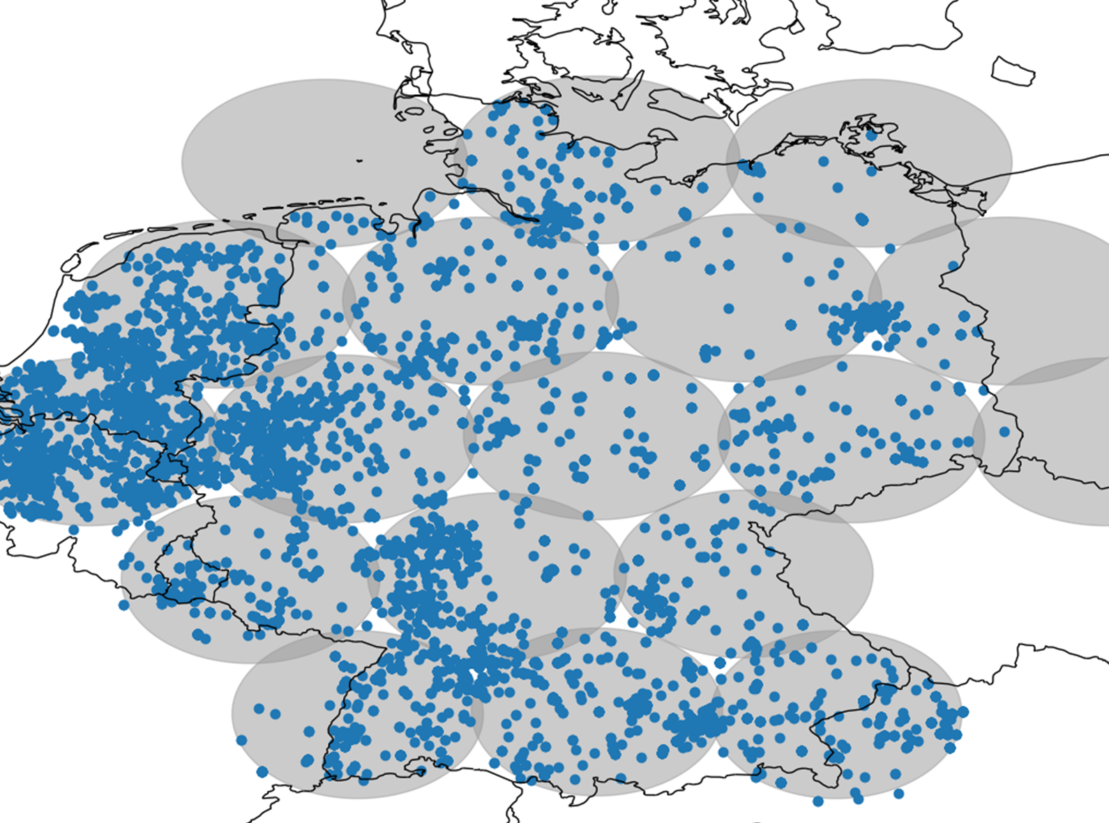
In many cases the web page restrict the result items to a fixed number. With geoiter you can now dissect this one query to a many location queries to relax the result density under the restriction limit.
geoiter has only one additional dependency called haversine.
install
pip install geoiter
usage
import pickle

from geoiter.util.ressource_example import germany
from geoiter import GeoIter

# get you boundary for example
with open(germany, "rb") as file:
    germany = pickle.load(file)

# prepare
gi = GeoIter(
    boundary=germany,
    radius=100,
    comp_rate=20
    )

if __name__ == "__main__":
    # plot them as example
    for coordinate in gi:
        print(coordinate)
speed
one may consider that geo data have megabytes of coordinates. Which may make the iteration very slow, because it needs to look up coordinates in the boundary often. To accelerate the geoiter provides a very simple compressor and uses bisect instead of list iteration. However, it still can be slow.
extensions
There two extensions which give additional help
pip install geoiter["gpx]
provides you with an gpx exporter.
pip install geoiter["plot"]
provides a plotting function to visualize the grid.
data
get boundaries from osm or others sources like
todo
- SRP for compressor
- Make own haversine calculation for fixed directions.
Homepage
Permission is hereby granted, free of charge, to any person obtaining a copy of this software and associated documentation files (the “Software”), to deal in the Software without restriction, including without limitation the rights to use, copy, modify, merge, publish, distribute, sublicense, and/or sell copies of the Software, and to permit persons to whom the Software is furnished to do so, subject to the following conditions:
The above copyright notice and this permission notice shall be included in all copies or substantial portions of the Software.
THE SOFTWARE IS PROVIDED “AS IS”, WITHOUT WARRANTY OF ANY KIND, EXPRESS OR IMPLIED, INCLUDING BUT NOT LIMITED TO THE WARRANTIES OF MERCHANTABILITY, FITNESS FOR A PARTICULAR PURPOSE AND NONINFRINGEMENT. IN NO EVENT SHALL THE AUTHORS OR COPYRIGHT HOLDERS BE LIABLE FOR ANY CLAIM, DAMAGES OR OTHER LIABILITY, WHETHER IN AN ACTION OF CONTRACT, TORT OR OTHERWISE, ARISING FROM, OUT OF OR IN CONNECTION WITH THE SOFTWARE OR THE USE OR OTHER DEALINGS IN THE SOFTWARE.
Release history Release notifications | RSS feed


Download files
Download the file for your platform. If you're not sure which to choose, learn more about installing packages.
Source Distribution
Built Distribution
Filter files by name, interpreter, ABI, and platform.
If you're not sure about the file name format, learn more about wheel file names.
Copy a direct link to the current filters
File details
Details for the file geoiter-0.1.1.tar.gz.
File metadata
- Download URL: geoiter-0.1.1.tar.gz
- Upload date:
- Size: 9.7 kB
- Tags: Source
- Uploaded using Trusted Publishing? No
- Uploaded via: twine/3.8.0 pkginfo/1.8.2 readme-renderer/34.0 requests/2.27.1 requests-toolbelt/0.9.1 urllib3/1.26.9 tqdm/4.63.0 importlib-metadata/4.11.3 keyring/23.5.0 rfc3986/1.5.0 colorama/0.4.4 CPython/3.10.0
File hashes
| Algorithm | Hash digest | |
|---|---|---|
| SHA256 |
a79f346e6cde9f8cfe4598cab2abdc9d1ed25535da1985314e2b8783b8572c39
|
|
| MD5 |
752fdb4b06bbec57a18ac48967d0ee6d
|
|
| BLAKE2b-256 |
b53c64b296bc4acdba80ceafcc56ccef3ac33d3ceb93c8437d8d8a469b87953d
|
File details
Details for the file geoiter-0.1.1-py3-none-any.whl.
File metadata
- Download URL: geoiter-0.1.1-py3-none-any.whl
- Upload date:
- Size: 8.4 kB
- Tags: Python 3
- Uploaded using Trusted Publishing? No
- Uploaded via: twine/3.8.0 pkginfo/1.8.2 readme-renderer/34.0 requests/2.27.1 requests-toolbelt/0.9.1 urllib3/1.26.9 tqdm/4.63.0 importlib-metadata/4.11.3 keyring/23.5.0 rfc3986/1.5.0 colorama/0.4.4 CPython/3.10.0
File hashes
| Algorithm | Hash digest | |
|---|---|---|
| SHA256 |
eda0adc47e03324d34302233d8c03b317e0a8598e192f0c9656972ae19ac495a
|
|
| MD5 |
7d1a4fcf33e35ce6c5ba1c0da1670637
|
|
| BLAKE2b-256 |
d9b525ed040a57aa88011842f30068a4125c4bcdaecd7b3db37d52b63f29a318
|


