Toolkits for Geospatial Machine Learning

Project description
Geo ML Toolkits
Toolkits for GeoML workflows
Currently it supports for downloading and processing geospatial data from Open Aerial Map (OAM) and OpenStreetMap (OSM). This toolkit allows you to define an area of interest, download aerial imagery and OSM data, and generate training data for machine learning models.
Installation
To install the GeoML Toolkits, you can use pip:
pip install geomltoolkits
Usage
Python Example
Below is an example of how to use the GeoML Toolkits to download and process geospatial data.
import os
from geomltoolkits.downloader import tms as TMSDownloader
from geomltoolkits.downloader import osm as OSMDownloader

# Define area of interest
ZOOM = 18
WORK_DIR = "banepa"
TMS = "https://tiles.openaerialmap.org/62d85d11d8499800053796c1/0/62d85d11d8499800053796c2/{z}/{x}/{y}"
BBOX = [85.514668, 27.628367, 85.528875, 27.638514]

# Create working directory
os.makedirs(WORK_DIR, exist_ok=True)

# Download tiles
await TMSDownloader.download_tiles(
    tms=TMS,
    zoom=ZOOM,
    out=WORK_DIR,
    bbox=BBOX,
    georeference=True,
    dump_tile_geometries_as_geojson=True,
    prefix="OAM"
)

# Download OSM data for tile boundary
tiles_geojson = os.path.join(WORK_DIR, "tiles.geojson")
await OSMDownloader.download_osm_data(
    geojson=tiles_geojson,
    out=os.path.join(WORK_DIR, "labels"),
    dump_results=True,
    split_output_by_tiles=True
)
Learn more here
Command Line Usage
if you install the python package it will by default install following commands
- tmd: tms downloader
- osd : openstreetmap downloader
- reg : footprints regularizer
You can see the helper function and shoot your command
You can also use the provided Bash script to run the GeoML Toolkits from the command line. Take a look here
Splitting OSM Data
If the split argument is set to True, the downloaded OSM data will be split based on the tiles defined in tiles.geojson. Each resulting GeoJSON file will be named according to the tile's x, y, and z values.
Installation and Setup
Prerequisites
- Python 3.10 or higher
- uv
Install
uv sync
Install lib locally
uv run pip install -e .
Detailed Usage Instructions
Downloading Tiles
To download tiles from a Tile Map Service (TMS), you can use the download_tiles function from the tms module. Here is an example:
import os
from geomltoolkits.downloader import tms as TMSDownloader

# Define area of interest
ZOOM = 18
WORK_DIR = "banepa"
TMS = "https://tiles.openaerialmap.org/62d85d11d8499800053796c1/0/62d85d11d8499800053796c2/{z}/{x}/{y}"
BBOX = [85.514668, 27.628367, 85.528875, 27.638514]

# Create working directory
os.makedirs(WORK_DIR, exist_ok=True)

# Download tiles
await TMSDownloader.download_tiles(
    tms=TMS,
    zoom=ZOOM,
    out=WORK_DIR,
    bbox=BBOX,
    georeference=True,
    dump_tile_geometries_as_geojsondump=True,
    prefix="OAM"
)
Downloading OSM Data
To download OpenStreetMap (OSM) data for a given area of interest, you can use the download_osm_data function from the osm module. Here is an example:
import os
from geomltoolkits.downloader import osm as OSMDownloader

# Define area of interest
WORK_DIR = "banepa"
tiles_geojson = os.path.join(WORK_DIR, "tiles.geojson")

# Download OSM data for tile boundary
await OSMDownloader.download_osm_data(
    geojson=tiles_geojson,
    out=os.path.join(WORK_DIR, "labels"),
    dump_results=True,
    split_output_by_tiles=True,
)
Regularizing Footprints
This repo utiltizes a digital art technique to vectorize features from masks using our awesome old potrace library . Potrace is not meant for geospatial workflows however it does excellent job on tracing vector graphics from raster. I thought it would easily overcome the current rasteriation issues of irregular geometries and hence worked on the spatial integration . Below is the example how potrace works
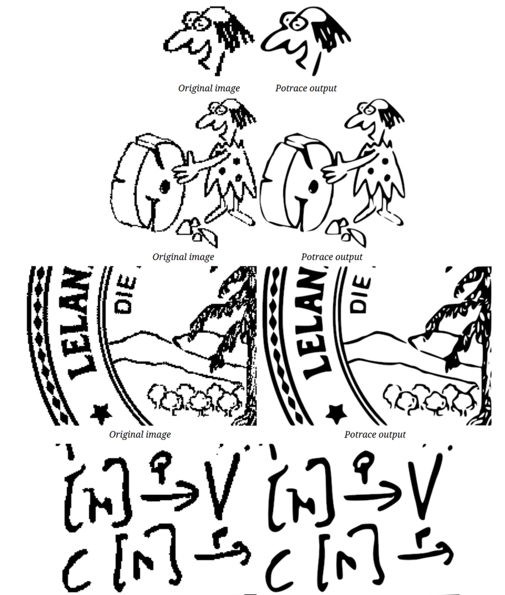
Repo uses orthogonalization script and potrace also provides rasterio rasterization option as well !
Example of vectorization output :
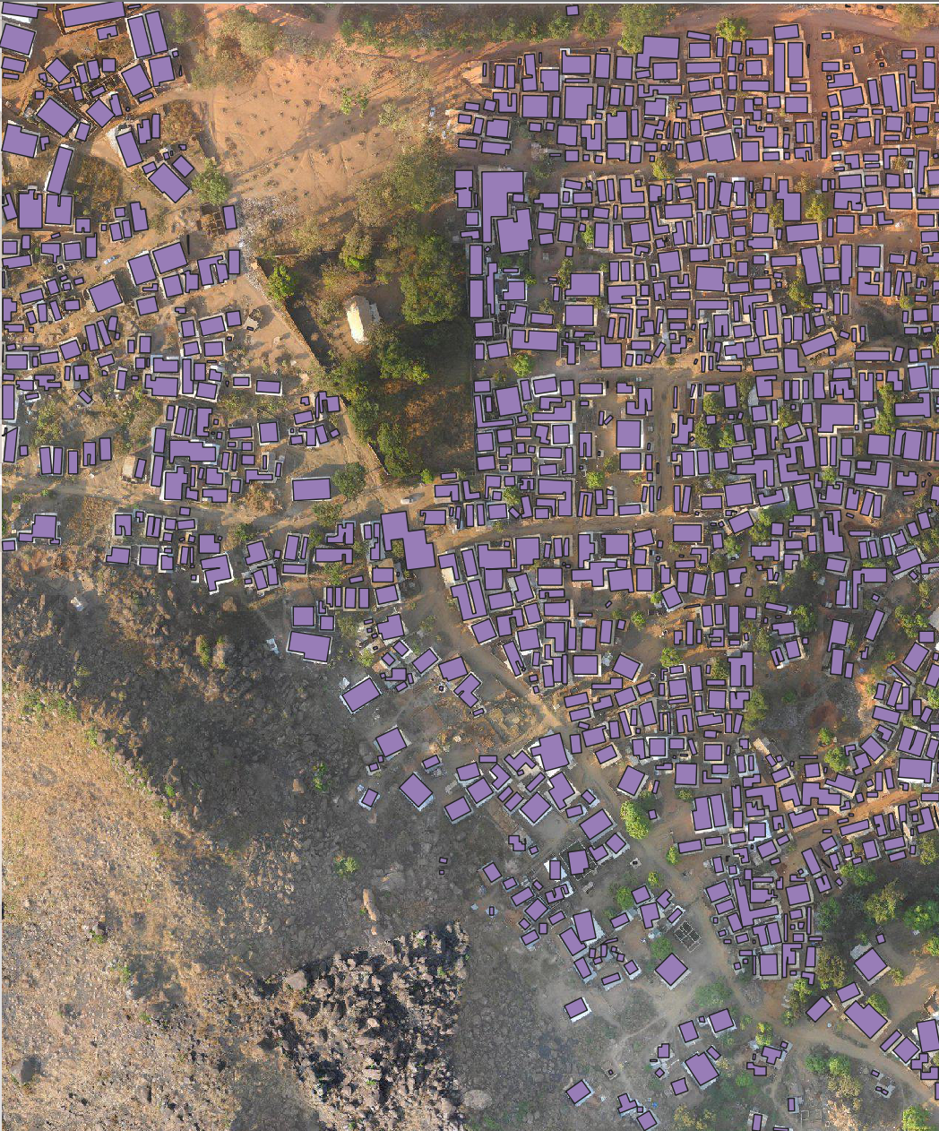
To regularize building footprints, you can use the VectorizeMasks class from the regularizer module. Here is an example:
import os
from geomltoolkits.regularizer import VectorizeMasks

# Define input and output files
input_tiff = "path/to/input.tiff"
output_geojson = "path/to/output.geojson"

# Create a VectorizeMasks instance
converter = VectorizeMasks(
    simplify_tolerance=0.2,
    min_area=1.0,
    orthogonalize=True,
    algorithm="potrace",
    tmp_dir=os.getcwd()
)

# Run the conversion
converter.convert(input_tiff, output_geojson)
Command Line Usage
The GeoML Toolkits also provide command line interfaces for downloading tiles, downloading OSM data, and regularizing footprints. Here are the commands:
- tmd: TMS downloader
- osd: OpenStreetMap downloader
- reg: Footprints regularizer
You can use the --help option with each command to see the available options and usage instructions. For example:
tmd --help
osd --help
reg --help
Example Usage
For a complete example of how to use the GeoML Toolkits, you can refer to the example_usage.ipynb notebook. It provides detailed explanations and usage examples for all functionalities.
Installation Steps
To install the GeoML Toolkits, you can use pip:
pip install geomltoolkits
If you want to install the library locally for development, you can use the following commands:
pip install -e .
Running the Bash Script
You can also use the provided Bash script to run the GeoML Toolkits from the command line. Here is an example:
./run.sh
The script will download tiles, download OSM data, and regularize footprints based on the specified parameters.
Release history Release notifications | RSS feed


Download files
Download the file for your platform. If you're not sure which to choose, learn more about installing packages.
Source Distribution
Built Distribution
Filter files by name, interpreter, ABI, and platform.
If you're not sure about the file name format, learn more about wheel file names.
Copy a direct link to the current filters
File details
Details for the file geomltoolkits-0.3.8.tar.gz.
File metadata
- Download URL: geomltoolkits-0.3.8.tar.gz
- Upload date:
- Size: 180.1 kB
- Tags: Source
- Uploaded using Trusted Publishing? No
- Uploaded via: uv/0.7.19
File hashes
| Algorithm | Hash digest | |
|---|---|---|
| SHA256 |
bf2aba95b6bb687cbe04617c84ec0f60731f3cfc9815acabd209c8fe94c361e3
|
|
| MD5 |
2c551dd09884a6f5f4920dea1412ac88
|
|
| BLAKE2b-256 |
2ec9b41394ecc19162b5abff251c855c802dddaa08dadd8af1ab6e3344268c01
|
File details
Details for the file geomltoolkits-0.3.8-py3-none-any.whl.
File metadata
- Download URL: geomltoolkits-0.3.8-py3-none-any.whl
- Upload date:
- Size: 25.9 kB
- Tags: Python 3
- Uploaded using Trusted Publishing? No
- Uploaded via: uv/0.7.19
File hashes
| Algorithm | Hash digest | |
|---|---|---|
| SHA256 |
e3f3f6150665c24492673116eae33f9dbeb03592c43e6b6f435f5575bb654673
|
|
| MD5 |
83e675b415eb52b941f31cc46b7977aa
|
|
| BLAKE2b-256 |
1c8a88e87f45c60e78fc8037849a5c7592fd92abcca77a4a32b9a0d9038e3020
|


