Lightweight reader for raster files
Project description
georeader
Read data from rasters: very few dependencies, reads from cloud storage and lazy loading.
Install
# Install with minimal requirements (only rasterio, numpy as shapely)
pip install git+https://github.com/spaceml-org/georeader#egg=georeader

# Install with Google dependencies (to read objects from Google Cloud Storage or Google Earth Engine)
pip install git+https://github.com/spaceml-org/georeader#egg=georeader[google]

# Install with Planetary Computer requirements
pip install git+https://github.com/spaceml-org/georeader#egg=georeader[microsoftplanetary]
Getting started
# This snippet requires:
# pip install fsspec gcsfs google-cloud-storage
import os
os.environ["GS_NO_SIGN_REQUEST"] = "YES"

from georeader.readers import S2_SAFE_reader
from georeader import read

cords_read = (-104.394, 32.026) # long, lat
crs_cords = "EPSG:4326"
s2_safe_path = S2_SAFE_reader.s2_public_bucket_path("S2B_MSIL1C_20191008T173219_N0208_R055_T13SER_20191008T204555.SAFE")
s2obj = S2_SAFE_reader.s2loader(s2_safe_path,
                                out_res=10, bands=["B04","B03","B02"])

# copy to local avoids http errors specially when not using a Google project.
# This will only copy the bands set up above B04, B03 and B02
s2obj = s2obj.cache_product_to_local_dir(".")

# See also read.read_from_bounds, read.read_from_polygon for different ways of croping an image
data = read.read_from_center_coords(s2obj,cords_read, shape=(2040, 4040),
                                    crs_center_coords=crs_cords)

data_memory = data.load() # this loads the data to memory

data_memory # GeoTensor object
>>  Transform: | 10.00, 0.00, 537020.00|
| 0.00,-10.00, 3553680.00|
| 0.00, 0.00, 1.00|
         Shape: (3, 2040, 4040)
         Resolution: (10.0, 10.0)
         Bounds: (537020.0, 3533280.0, 577420.0, 3553680.0)
         CRS: EPSG:32613
         fill_value_default: 0
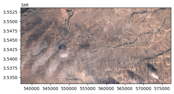
In the .values attribute we have the plain numpy array that we can plot with show:
from rasterio.plot import show
show(data_memory.values/3500, transform=data_memory.transform)

Saving the GeoTensor as a COG GeoTIFF:
from georeader.save import save_cog

# Supports writing in bucket location (e.g. gs://bucket-name/s2_crop.tif)
save_cog(data_memory, "s2_crop.tif", descriptions=s2obj.bands)
Tutorials
Sentinel-2:
- Reading Sentinel-2 images from the public Google bucket
- Explore metadata of Sentinel-2 object
- Query Sentinel-2 images over a location and time span, mosaic and plot them
Other:
- Tutorial to read overlapping tiles from a GeoTIFF and a Sentinel-2 image
- Example of reading a Proba-V image overlapping with Sentinel-2 forcing same resolution
- Work with EMIT images
Citation
If you find this code useful please cite:
@software{georeader,
  author = {Mateo-García, Gonzalo},
  month = {11},
  title = {{georeader}},
  url = {https://github.com/spaceml-org/georeader},
  version = {1.0.2},
  year = {2022}
}
Project details
Release history Release notifications | RSS feed
Download files
Download the file for your platform. If you're not sure which to choose, learn more about installing packages.
Source Distribution
georeader-spaceml-1.0.3.tar.gz
(126.9 kB
view hashes)
Built Distribution
Close
Hashes for georeader_spaceml-1.0.3-py3-none-any.whl
| Algorithm | Hash digest | |
|---|---|---|
| SHA256 | 74e91d5686effdf2d2e58cdc64e7b01b07e9f7e0d22df98cddf51e56dae4ef7c |
|
| MD5 | b042a0983f865fd3591511d0b9d6b941 |
|
| BLAKE2b-256 | e3cde0ffd49a9a67b05b127a854855b59c4e0580156570f9e111a4237c521cd0 |


