
glofas-ewds
Is this river high for this river? GloFAS river discharge and the Copernicus Fire Weather Index from the Early Warning Data Store, read on the right grid cell.





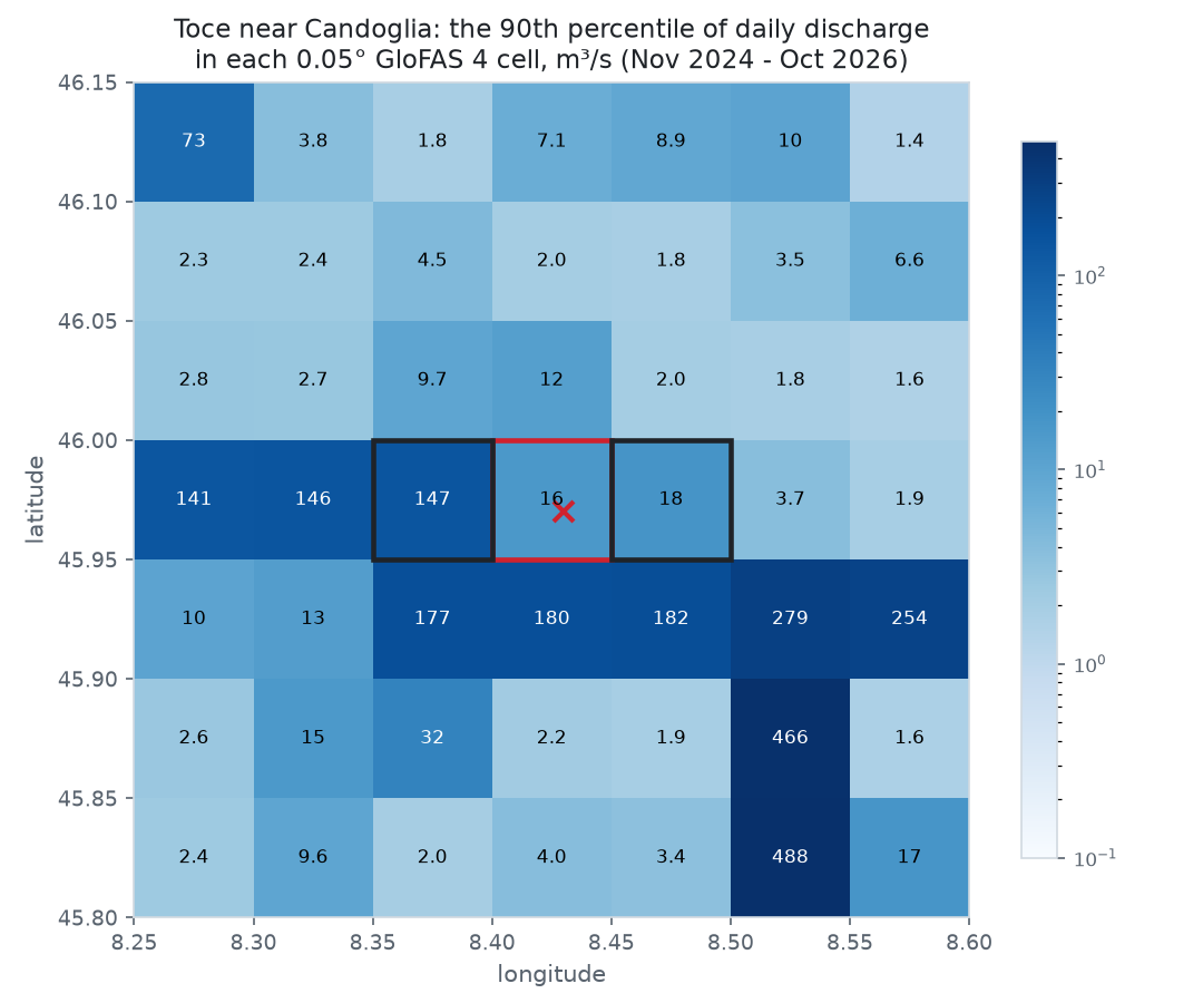
open_meteo_cell(8.43, 45.97)  # (8.475, 45.975): the cell whose numbers you are really reading
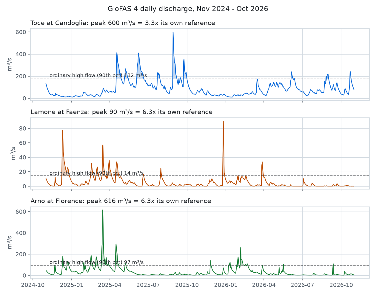
discharge_ratio(600.2, 181.9)  # 3.3: the Toce's peak against its own ordinary high flow
docs/make_images.py.
- What is it, in 30 seconds
- Who is it for
- Quick start
- How it works
- Recipes
- The traps we already fell into
- API at a glance
- Data licence and credits
What is it, in 30 seconds
GloFAS, the Global Flood Awareness System of Copernicus, models the discharge of every river on Earth on a 0.05° grid (about 5 km), every day, with a forecast for the days ahead. The Early Warning Data Store (EWDS) serves it as NetCDF grids, together with the Fire Weather Index Copernicus computes on ERA5.
The data is free. Using it well is not: a cell too far west turns a river into a creek, a model version too new halves every number, and a recent month asked for the wrong way does not exist. This package holds the requests and the readers that get those right.
| What you get | |
|---|---|
| 🎯 | The right cell for a point: open_meteo_cell, the same cell Open-Meteo serves, so a reference from the EWDS and a forecast from Open-Meteo describe the same water |
| 📜 | The requests, built for you: GloFAS 4 history (consolidated, then intermediate), the 00 UTC control forecast, the six FWI components; split by month |
| 📦 | Downloads you can re-run: one file per month or run, nothing asked twice, never half a file left behind |
| 📈 | Numbers per node: daily series, forecast peaks, FWI components, for your own list of points |
| 📏 | A reference per river: references and discharge_ratio, the forecast peak against the node's own ordinary high flow |
| 🧪 | Pure where it can be: import glofas_ewds needs only numpy; cdsapi and netCDF4 are extras |
Who is it for
- Anyone who turns GloFAS into alerts or scores: a flood model, a dashboard, a newsroom map. A ratio to the river's own high flow is comparable between the Po and a torrent; a raw m³/s is not.
- People who already read the Open-Meteo flood API and want the history in bulk from Copernicus instead of node by node, without the two disagreeing.
- Fire-weather people checking their own FWI against the Copernicus one.
It was extracted from Limen, the landslide, flood and wildfire monitor for Italy, where it fills the reference of 3,366 river nodes from about 25 monthly requests instead of about 52 calls per node to a public API capped at 10,000 calls a day. On 36,637 points (the whole 0.1° lattice of Italy plus 20,000 random ones) it picks the same cell as Limen's own code, and every request and reader gives identical results.
Quick start
pip install "glofas-ewds[ewds,netcdf]"
You need an EWDS account and its API
key, in CDSAPI_URL / CDSAPI_KEY or ~/.cdsapirc, and you must accept the
licence of each dataset once on its page.
import asyncio
from datetime import date

from glofas_ewds import (
    EwdsClient,
    discharge_ratio,
    discharge_series,
    forecast_peaks,
    references,
)

NODES = [(8.43, 45.97), (11.88, 44.29), (11.25, 43.77)]  # Toce, Lamone, Arno


async def main() -> None:
    ewds = EwdsClient("data/ewds")
    start, end = date(2024, 11, 1), date(2026, 10, 31)

    history = await ewds.history(start, end)  # 24 monthly files
    ref = references(discharge_series(history, NODES, start=start, end=end), p=0.9)

    latest = await ewds.latest_forecast()  # today's run, or yesterday's
    if latest is not None:
        run, path = latest
        for node, peak in forecast_peaks(path, NODES).items():
            print(run, node, round(peak), discharge_ratio(peak, ref[node]))


asyncio.run(main())
Each EWDS request waits in a queue, often for minutes; EwdsClient waits in a
thread, so your event loop keeps serving. No live output is shown here: this
release was built without an EWDS key, and the readers were checked against
synthetic files and against Limen's code.
How it works
flowchart LR
    N["your nodes<br/>(lon, lat)"] --> C["open_meteo_cell<br/>the cell to read"]
    R["historical_request<br/>forecast_request<br/>fire_request"] --> Q["EWDS queue<br/>(cdsapi)"]
    Q -->|"NetCDF, one per month / run"| D["download_*<br/>.part, then rename"]
    D --> S["discharge_series<br/>forecast_peaks<br/>fire_values"]
    C --> S
    S --> P["references (p90)<br/>discharge_ratio"]
Recipes
A reference without an account. The pure parts work on any series:
from glofas_ewds import references

references({"toce": series}, p=0.9, min_days=365)  # None below a year of days
Your own retry, budget or timeout. Every download takes any object with
retrieve(dataset, request, target):
from glofas_ewds import cdsapi_client, download_history

download_history(folder, start, end, client=MyQueueWithTimeout(cdsapi_client()))
Another area. Every request and download takes area=(north, west, south, east); files for an area other than Italy carry the area in their name, so
two areas can share a folder.
The official FWI next to yours.
files = await ewds.fire(date(2025, 6, 1), date(2025, 9, 30))
fire_values(files, nodes)  # {(node, day): {"fwi": ..., "ffmc": ..., "dc": ...}}
The traps we already fell into
- Open-Meteo's numbers belong to the cell one step east. Open-Meteo
declares a cell for each point, but the values it returns are the ones the
EWDS labels 0.05° further east: on 28 real nodes, 28 matched with the
shift and 0 without it. On the Toce that is 2 m³/s against 22. Comparing
the declared coordinates does not show it.
open_meteo_cellapplies the shift. - The cell is picked in float32. Open-Meteo rounds away from zero from an origin at -59.975 / -180.025 in single precision, so on the edge between two cells it goes up for some points and down for others. Doing it in float64 can pick the other neighbour.
- The cell next door is another river. In the map above the cell under the point holds 16 m³/s and the one west of it 147. Never interpolate GloFAS between cells, and never trust a point without checking its cell.
- GloFAS 4, not 5. Open-Meteo's forecast is GloFAS 4 (at Faenza on
11 October 2026: 7.1 / 6.1 / 8.9 m³/s from the EWDS against 7.3 / 5.9 / 8.9
from Open-Meteo); version 5 gives about half. A v4 forecast over a v5
reference is a number without meaning. The requests pin
version_4_0. - Recent months are "intermediate". The consolidated history arrives months late (on 11 October 2026 it ended in June; intermediate reached 8 October). Asking a recent month as consolidated answers "not a valid combination"; the downloads then ask it as intermediate, and only for that error.
valid_timeis the end of the day. The EWDS stamps a daily mean with the end of its 24 hours, the day after the one you asked for.discharge_serieskeys values by the day asked.- Accept the licence first. Every dataset has a licence to accept once on its EWDS page; until then each request answers 403, which looks like a bad key. That error is never turned into "intermediate".
- FWI variables have GRIB names. In the fire NetCDF the variables are
fwinx,drtcode, ..., not the names you asked for;fire_valuesfinds them bylong_name. The build-up index is "Fire buildup index" there. - Mind the quotas. The public Open-Meteo API caps at 10,000 calls a day, and two years of discharge cost about 52 calls per node. The EWDS gives the same history as a grid: two years of Italy are 24 or 25 monthly requests.
- Absent is not zero. A node outside the file or on a masked cell (sea,
no river network) gets no value.
discharge_ratioreturnsNonewhen it does not know how big the river is, never a reassuring 0.
API at a glance
| Name | What it does |
|---|---|
open_meteo_cell(lon, lat) / declared_cell(lon, lat) |
the cell Open-Meteo serves / the one it declares |
historical_request, forecast_request, fire_request, months |
the EWDS requests, without sending them |
download_history, download_forecast, download_fire |
one NetCDF per month or run, re-runnable, with any retrieve client |
EwdsClient(folder, *, url=None, key=None, retriever=None, area=ITALY) |
the same downloads, async, plus latest_forecast() |
discharge_series, forecast_peaks, fire_values |
NetCDF to numbers per node (extra netcdf) |
percentile, references, discharge_ratio |
a river's own reference, and how far above it a forecast is |
candidate_runs(today, latest_saved=None) |
the forecast runs worth trying, newest first |
GlofasEwdsError |
the package's exception |
The full reference is on the documentation site.
Development
uv sync
make check   # ruff, mypy --strict, pytest with coverage
make docs    # the documentation site, built with --strict
uv run --group docs python docs/make_images.py   # the README figures
Data licence and credits
- GloFAS (CEMS-Floods). Under the CEMS-FLOODS datasets licence. If you publish data derived from it, say so with a notice such as "Contains modified Copernicus Emergency Management Service information [Year]". The data is provided for information only: a ratio computed with this package is not a flood warning, and must not be presented as one. Official warnings come from your national and regional services.
- Fire danger (
cems-fire-historical-v1). © Copernicus Emergency Management Service, under the licence stated on its EWDS page, to be accepted once there. - The figures use GloFAS 4 discharge served by the Open-Meteo flood API (CC BY 4.0). Contains modified Copernicus Emergency Management Service information 2026.
This package is not affiliated with Copernicus, ECMWF, the JRC or Open-Meteo. Code under Apache-2.0.
1 maintainer

Metadata
1 maintainer
Release files for glofas-ewds 0.1.0
For a detailed explanation of source distributions (sdists) and built distributions (wheels), please see the package formats documentation.
Source distribution (sdist)
| File | Size | Uploaded | Provenance | Actions |
|---|---|---|---|---|
| glofas_ewds-0.1.0.tar.gz | 25.7 kB | With provenance | Details for glofas_ewds-0.1.0.tar.gz |
Built distribution (wheel)
| File | Interpreter | ABI | Platform | Actions Reset |
|---|---|---|---|---|
| glofas_ewds-0.1.0-py3-none-any.whl | Python 3 | none | any | Details for glofas_ewds-0.1.0-py3-none-any.whl |
Total release size: 50.4 kB
Release files / glofas_ewds-0.1.0.tar.gz
| Download URL | glofas_ewds-0.1.0.tar.gz |
|---|---|
| Size | 25.7 kB |
| Tags | Source |
|
SHA-256 checksum How to use checksums |
aac23eefb815547e728b9ce2f4d40fa5d0ed016578166eb4b92ee7bc798008af
|
|
BLAKE2b-256 checksum How to use checksums |
380f0806b5247cf82c19f0cbd6fd4e55b47b58001be7ecc1a4d1e70566d2bbc6
|
| Upload date | |
|
Uploaded using Trusted Publishing? What is trusted publishing? |
Yes |
| Uploaded via |
twine/7.0.0 CPython/3.13.16
|
Provenance
Provenance describes where a file came from. On PyPI, provenance is shared via attestations, which provide a verifiable record of the build or publishing details. View details, limitations and caveats.


PyPI Publish Attestation
PyPI verified that this artifact, at this checksum, originated from the publisher listed below.
Signed by GitHub Actions, verified by PyPI on Nov 4, 2026.
Transparency logRelease files / glofas_ewds-0.1.0-py3-none-any.whl
| Download URL | glofas_ewds-0.1.0-py3-none-any.whl |
|---|---|
| Size | 24.8 kB |
| Tags | Python 3 |
|
SHA-256 checksum How to use checksums |
785d5caa2845594536b253b7e05e12e3b98766bf11a3688e5879b5eeec634183
|
|
BLAKE2b-256 checksum How to use checksums |
1b8a43fca061bdcf2545a25f6c595da06a19b711d9dc42f5e5c39192b9d05b90
|
| Upload date | |
|
Uploaded using Trusted Publishing? What is trusted publishing? |
Yes |
| Uploaded via |
twine/7.0.0 CPython/3.13.16
|
Provenance
Provenance describes where a file came from. On PyPI, provenance is shared via attestations, which provide a verifiable record of the build or publishing details. View details, limitations and caveats.
PyPI Publish Attestation
PyPI verified that this artifact, at this checksum, originated from the publisher listed below.
Signed by GitHub Actions, verified by PyPI on Nov 4, 2026.
Transparency logSecurity for glofas-ewds 0.1.0
Provenance
Provenance describes where a file came from. On PyPI, provenance is shared via attestations, which provide a verifiable record of the build or publishing details. View details, limitations and caveats.
Full provenance
Both files in this release have been uploaded with provenance metadata.
Attestation for glofas_ewds-0.1.0.tar.gz
PyPI Publish Attestation
PyPI verified that this artifact, at this checksum, originated from the publisher listed below.
Signed by GitHub Actions, verified by PyPI on Nov 4, 2026.
Transparency logA note on package security
PyPI is a repository for distributing packages, not a service for auditing them. While third-party security researchers and our staff do their best to detect and remove malicious packages, PyPI cannot guarantee the quality, security or suitability of any given package.
To learn more about protecting yourself from malicious actors, visit our package security documentation.














