Correct aerial and satellite imagery to surface reflectance.
Verified details
These details have been verified by PyPIProject links
GitHub Statistics
Maintainers

Project description


homonim
Correct drone, aerial and satellite imagery to surface reflectance.
Description
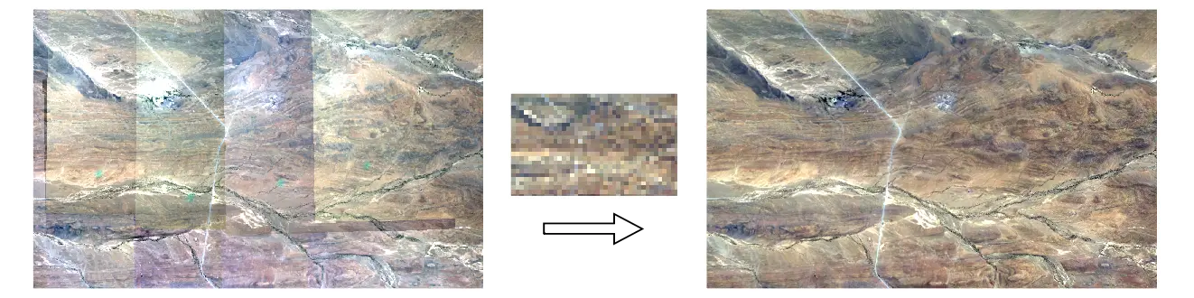
homonim provides a command line interface and API for correcting remotely sensed imagery to approximate surface reflectance. It implements a form of spectral harmonisation, that adjusts for spatially varying atmospheric and anisotropic (BRDF) effects, by fusion with satellite surface reflectance data. Manual reflectance measurements and target placements are not required.
homonim is useful for pre-processing in quantitative mapping applications, and for reducing seamlines and other visual artefacts in image mosaics. It can be applied to multi-spectral drone, aerial and satellite imagery. The consistency of multi-temporal and multi-sensor data can improved through its use.
See the documentation site for more detail: https://homonim.readthedocs.io/.
Installation
homonim is available as a python 3 package, via pip or conda.
pip
pip install homonimconda
conda install -c conda-forge homonimGetting started
Command line interface
homonim command line functionality is accessed through the commands:
fuse: Correct image(s) to surface reflectance.
compare: Compare image(s) with a reference.
stats: Report parameter statistics.
Get help on homonim with:
homonim --helpand help on a homonim command with:
homonim <command> --helpExamples
Correct source.tif to surface reflectance by fusion with reference.tif, using the default settings:
homonim fuse source.tif reference.tifCorrect images matching source*.tif to surface reflectance by fusion with reference.tif. Use a 5 x 5 pixel kernel and the gain-blk-offset model for correction, and place corrected images in the ./corrected directory:
homonim fuse -k 5 5 -m gain-blk-offset -od ./corrected source*.tif reference.tifStatistically compare source.tif and corrected.tif with reference.tif.
homonim compare source.tif corrected.tif reference.tifAPI
Example
Surface reflectance correction of an aerial image using a Sentinel-2 reference.
from homonim import RasterFuse, Model

# urls of source and reference test images
src_file = (
    'https://raw.githubusercontent.com/leftfield-geospatial/homonim/main/'
    'tests/data/source/ngi_rgb_byte_1.tif'
)
ref_file = (
    'https://raw.githubusercontent.com/leftfield-geospatial/homonim/main/'
    'tests/data/reference/sentinel2_b432_byte.tif'
)

# path to corrected file to create
corr_file = './corrected.tif'

# Correct src_file to surface reflectance by fusion with ref_file, using the
# `gain-blk-offset` model and a kernel of 5 x 5 pixels.
with RasterFuse(src_file, ref_file) as fuse:
    fuse.process(corr_file, Model.gain_blk_offset, (5, 5), overwrite=True)
Reference imagery
geedim can be used as a companion tool for searching and downloading cloud-free reference imagery. Alternatively, satellite imagery is available from a number of sources, including the Google, Amazon and Microsoft repositories.
Usage
See the documentation here.
Terminology
homonim is shorthand for homogenise image and is a reference to the paper on which it is based.
Credits
homonim relies on these excellent packages:
License
homonim is licensed under the terms of the AGPLv3. This project is developed in collaboration with InnovUS at Stellenbosch University, alternative licenses can be arranged by contacting them.
Citation
Please cite use of the code as:
Dugal Harris & Adriaan Van Niekerk (2019) Radiometric homogenisation of aerial images by calibrating with satellite data, International Journal of Remote Sensing, 40:7, 2623-2647, DOI: https://doi.org/10.1080/01431161.2018.1528404.
Bibtex:
@article{doi:10.1080/01431161.2018.1528404,
    author = {Dugal Harris and Adriaan Van Niekerk},
    title = {Radiometric homogenisation of aerial images by calibrating with satellite data},
    journal = {International Journal of Remote Sensing},
    volume = {40},
    number = {7},
    pages = {2623-2647},
    year  = {2019},
    publisher = {Taylor & Francis},
    doi = {10.1080/01431161.2018.1528404},
    URL = {https://doi.org/10.1080/01431161.2018.1528404},
}
Project details
Verified details
These details have been verified by PyPIProject links
GitHub Statistics
Maintainers
Release history Release notifications | RSS feed


Download files
Download the file for your platform. If you're not sure which to choose, learn more about installing packages.
Source Distribution
Built Distribution
Filter files by name, interpreter, ABI, and platform.
If you're not sure about the file name format, learn more about wheel file names.
Copy a direct link to the current filters
File details
Details for the file homonim-0.4.2.tar.gz.
File metadata
- Download URL: homonim-0.4.2.tar.gz
- Upload date:
- Size: 81.8 kB
- Tags: Source
- Uploaded using Trusted Publishing? Yes
- Uploaded via: twine/6.1.0 CPython/3.12.9
File hashes
| Algorithm | Hash digest | |
|---|---|---|
| SHA256 |
6733cd5b7ef3ba656c96e63e5d5dca643d92b84d4b379b3fd426fa2300698211
|
|
| MD5 |
2fae19151d7c8d53f496fd44499cdf4c
|
|
| BLAKE2b-256 |
cd9eb2af26d962428ae2cf3c643755e53a0e7e91ba0647ddd771f6d0fa760d80
|
Provenance
The following attestation bundles were made for homonim-0.4.2.tar.gz:
Publisher:
publish-pypi.yml on leftfield-geospatial/homonim
-
Statement:
-
Statement type:
https://in-toto.io/Statement/v1 -
Predicate type:
https://docs.pypi.org/attestations/publish/v1 -
Subject name:
homonim-0.4.2.tar.gz -
Subject digest:
6733cd5b7ef3ba656c96e63e5d5dca643d92b84d4b379b3fd426fa2300698211 - Sigstore transparency entry: 212198871
- Sigstore integration time:
-
Permalink:
leftfield-geospatial/homonim@d0dbef68fc2aa97d63cc56601ee940b98f82159e -
Branch / Tag:
refs/tags/v0.4.2 - Owner: https://github.com/leftfield-geospatial
-
Access:
public
-
Token Issuer:
https://token.actions.githubusercontent.com -
Runner Environment:
github-hosted -
Publication workflow:
publish-pypi.yml@d0dbef68fc2aa97d63cc56601ee940b98f82159e -
Trigger Event:
release
-
Statement type:
File details
Details for the file homonim-0.4.2-py3-none-any.whl.
File metadata
- Download URL: homonim-0.4.2-py3-none-any.whl
- Upload date:
- Size: 72.3 kB
- Tags: Python 3
- Uploaded using Trusted Publishing? Yes
- Uploaded via: twine/6.1.0 CPython/3.12.9
File hashes
| Algorithm | Hash digest | |
|---|---|---|
| SHA256 |
348a08ff70ffd08e1b7268a178d8b0f37eba630e2f1a9046191f698c6492e32d
|
|
| MD5 |
7c5421d5e3f6bd5669fa846535562bd0
|
|
| BLAKE2b-256 |
3e56320aba305dad5da183f5c679bb80abd03e51ad370803c5c365cc0262f462
|
Provenance
The following attestation bundles were made for homonim-0.4.2-py3-none-any.whl:
Publisher:
publish-pypi.yml on leftfield-geospatial/homonim
-
Statement:
-
Statement type:
https://in-toto.io/Statement/v1 -
Predicate type:
https://docs.pypi.org/attestations/publish/v1 -
Subject name:
homonim-0.4.2-py3-none-any.whl -
Subject digest:
348a08ff70ffd08e1b7268a178d8b0f37eba630e2f1a9046191f698c6492e32d - Sigstore transparency entry: 212198875
- Sigstore integration time:
-
Permalink:
leftfield-geospatial/homonim@d0dbef68fc2aa97d63cc56601ee940b98f82159e -
Branch / Tag:
refs/tags/v0.4.2 - Owner: https://github.com/leftfield-geospatial
-
Access:
public
-
Token Issuer:
https://token.actions.githubusercontent.com -
Runner Environment:
github-hosted -
Publication workflow:
publish-pypi.yml@d0dbef68fc2aa97d63cc56601ee940b98f82159e -
Trigger Event:
release
-
Statement type:


