





imageserver-export is a small, typed, async Python library that turns an area of any ArcGIS ImageServer into one clean GeoTIFF. Its first use is the open server of the European Environment Agency, which publishes the Copernicus Land Monitoring Service maps of all of Europe, at 10 m: how much of the ground is sealed by concrete and asphalt, how dense the trees are, where the grassland, the water and the wetlands are. No account, no key, no manual download.
async with ImageServer(eea("HRL_ImperviousnessDensity_2018")) as server:
    await server.export(Grid.from_lonlat((8.95, 45.33, 9.45, 45.62), res=100), Path("milan.tif"))
Three dependencies: httpx, numpy, rasterio.
Contents
- What is an ImageServer, in 30 seconds
- What this library does
- Who is it for
- Quick start
- The open maps of Europe
- How it works
- Why nearest neighbour
- Recipes
- The traps we already fell into
- API at a glance
- Data licence and credits
- Contributing
What is an ImageServer, in 30 seconds
Many public agencies publish their maps with ArcGIS Server. An
ImageServer is the part of it that serves rasters: grids of numbers, one
per pixel, like satellite-derived land cover. You give it a box, a size and
a coordinate system, and its exportImage operation sends back a picture of
that box.
That is enough to view a map, but not to use it. One request returns at most a few thousand pixels a side, so Italy at 10 m takes thousands of them. They have to line up exactly, or the pieces shift against each other. And when something goes wrong, the server still answers "200 OK", with an error message where the image should be.
This library does that part for you.
What this library does
| 🗺️ | One area, one GeoTIFF | Give it a longitude/latitude box and a resolution; get back one tiled, compressed GeoTIFF, georeferenced in the CRS you chose (LAEA Europe by default). |
| 📐 | Pixels that line up | The grid is snapped to whole pixels, and every request is a window of it: the server never resamples to fit, and tiles never shift. |
| 🧩 | Big areas in pieces | The area is cut into tiles the server accepts, fetched a few at a time, and pasted as they arrive. A whole country is just more tiles. |
| 🛟 | A file or nothing | The mosaic is written to out.tif.part and renamed only when every tile is in. A failure leaves nothing a later reader could mistake for a whole map. |
| 🚨 | Errors that say why | A JSON error sent with "200 OK", or a tile of the wrong size, stops the export with the server's own message. |
| 🏷️ | What the values mean | info() describes the service (pixel type, size, extent, largest image); attribute_table() gives the label of every pixel value. |
| 🔌 | Your HTTP, your rules | Bring your own httpx.AsyncClient, or a send function: a shared retry policy, a cache or a rate limiter then sees every request. |
Who is it for
- Researchers and analysts who need a Copernicus Land layer for a region, at the resolution of their own grid, in a script they can run again.
- Risk and climate tools that turn land cover into a factor per cell: sealed soil makes rain run off faster, tree cover feeds fires, wetlands change how floods spread.
- Anyone with an ArcGIS ImageServer to read, from the EEA or from a regional or national agency: the library is not tied to one server.
It was written for Limen, an open early-warning platform for landslides, floods and wildfires in Italy, which uses sealed soil to amplify the rain-driven flood trigger.
Quick start
1. Install
pip install imageserver-export
2. Export an area
import asyncio
from pathlib import Path

from imageserver_export import Grid, ImageServer, eea


async def main() -> None:
    async with ImageServer(eea("HRL_ImperviousnessDensity_2018")) as server:
        # Milan and its belt, at 100 m, in LAEA Europe (EPSG:3035).
        grid = Grid.from_lonlat((8.95, 45.33, 9.45, 45.62), res=100)
        result = await server.export(grid, Path("milan.tif"), valid_range=(0, 100))
        print(result.width, "x", result.height, "pixels,", f"{result.valid_fraction:.0%} valid")


asyncio.run(main())
valid_range=(0, 100) tells the library which values are real data: this
layer uses 254 for "unclassifiable" and 255 for "no data" (the sea, or
outside Europe), and both are kept in the file as they are.
3. Read it
The result is an ordinary GeoTIFF: open it in QGIS, or read it with
rasterio:
import rasterio

with rasterio.open("milan.tif") as src:
    band = src.read(1)
    sealed = band[band <= 100]
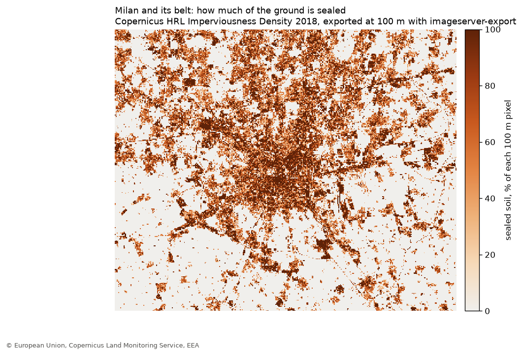
    print(f"mean sealed soil: {sealed.mean():.1f} %")  # ~25 % around Milan
The open maps of Europe
The EEA serves 26 Copernicus Land layers this way (eea(name) builds the
URL, list_services(f"{EEA_URL}/{EEA_FOLDER}") lists them). Among them:
Layer (eea(...)) |
What each pixel says | Native pixel |
|---|---|---|
HRL_ImperviousnessDensity_2018 |
% of the ground sealed by buildings, roads, car parks | 10 m |
HRL_TreeCoverDensity_2018 |
% of the ground under tree crowns | 10 m |
HRL_DominantLeafType2018 |
broadleaved or coniferous forest | 10 m |
HRL_Grassland_2018 |
grassland or not | 10 m |
HRL_WaterWetness_2018 |
permanent water, temporary water, wet and dry ground | 10 m |
HRL_SmallWoodyFeatures_2018_005m |
hedges, tree rows, small groves | 5 m |
HRL_ImperviousnessChange_15_18 |
how sealed soil changed, 2015 to 2018 | 20 m |
Each layer has a raster attribute table: await server.attribute_table()
returns, for the imperviousness layer, 102 rows such as
{"Value": 1, "Class_name": "1% imperviousness value", "Area_km2": 222.19}.
How it works
flowchart LR
    A["Grid.from_lonlat(box, res)"] --> B["plan(grid, tile_px)"]
    B --> C{{"exportImage<br/>per tile, 3 at a time"}}
    C -->|"GeoTIFF bytes"| D["check_image()"]
    C -->|"200 + JSON error"| X["ImageServerError"]
    D --> E["Mosaic.paste()<br/>size checked"]
    E --> F["out.tif.part"]
    F -->|"all tiles in"| G["out.tif"]
    F -->|"any failure"| H["deleted"]
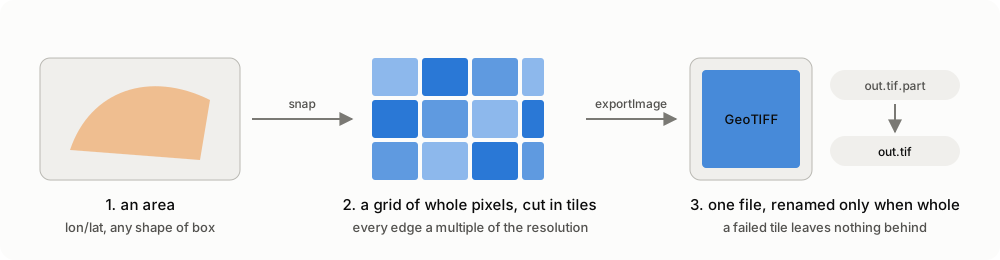
- The grid.
Grid.from_lonlatreprojects the box with densified edges (in an equal-area projection the sides of a geographic box curve, and its southern point is not a corner), then grows it outward to whole pixels. - The tiles.
plan()covers the grid exactly once, edge tiles clamped to it. Every tile's box is a multiple of the resolution, so the server returns exactly the size asked for, with no resampling. - The requests.
export_params()builds eachexportImagequery in the grid's own CRS, nearest neighbour by default.check_image()turns a JSON answer into an error with the server's message. - The mosaic.
Mosaicwrites a tiled, deflate-compressed GeoTIFF to.part, refuses a tile whose size differs from the one asked for, counts the valid pixels, and renames the file only on success.
Every step is a plain function or class you can use alone; ImageServer
just puts them together.
Why nearest neighbour
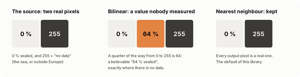
Many land-cover layers keep their "no data" marker in the same band as the data: 0 to 100 are percentages, 255 is "nothing here". Bilinear or cubic resampling averages neighbours, so between a 0 % field and a 255 sea pixel it can produce 64: a believable "64 % sealed", exactly where nothing was measured. Nothing downstream can tell it from a real value.
So the default is RSP_NearestNeighbor: every output pixel is one the
server really has. Pass interpolation="RSP_BilinearInterpolation" only for
continuous layers with no sentinel values.
Recipes
Tree cover of a region, at 20 m
grid = Grid.from_lonlat((15.3, 39.9, 16.9, 41.2), res=20)  # Basilicata
async with ImageServer(eea("HRL_TreeCoverDensity_2018")) as server:
    await server.export(
        grid,
        Path("basilicata_trees.tif"),
        valid_range=(0, 100),
        on_tile=lambda done, total: print(f"{done}/{total}"),
    )
Your own grid, in your CRS
# Snap to an existing 1 km grid in UTM 32N.
grid = Grid.snap((500_000, 4_500_000, 560_000, 4_560_000), res=1000, crs=32632)
Label the classes
async with ImageServer(eea("HRL_WaterWetness_2018")) as server:
    rows = await server.attribute_table()


# The label field is `Class_name` in some layers and `class_name` in others.
def label(row: dict) -> str | None:
    return next((v for k, v in row.items() if k.lower() == "class_name"), None)


labels = {row["Value"]: label(row) for row in rows}
# {0: 'Dry', 1: 'Permanent water', 2: 'Temporary water', 3: 'Permanent wet', ...}
Any other ImageServer
server = ImageServer("https://example.org/arcgis/rest/services/Elevation/ImageServer")
info = await server.info()  # pixel type, size, extent, largest image
await server.export(
    Grid.snap(box, res=info.pixel_size[0], crs=3857),
    Path("dem.tif"),
    pixel_type="F32",
    dtype="float32",
    nodata=None,
)
Bring your own HTTP
import httpx

async with httpx.AsyncClient(timeout=120) as client:  # your timeouts, proxies
    server = ImageServer(url, client, retries=5)


async def send(method: str, url: str, **kw) -> httpx.Response:
    return await my_retrying_client.request(method, url, **kw)  # your policy


server = ImageServer(url, send=send)  # every request goes through `send`
The traps we already fell into
- "200 OK" is not success. An ImageServer answers a bad request with HTTP 200 and a JSON error. Read as a TIFF, it is just "a corrupt file".
- Four corners are not a box. Reprojecting only the corners of Italy's longitude/latitude box to LAEA cut 6.8 km off the south: Lampedusa ended outside the raster, and 28 grid cells had no data.
- Rounding a box cuts it. Edges are grown to the next pixel, never rounded, or a strip of the area asked for goes missing.
- A tile of the wrong size shifts everything. It is refused, not pasted.
- A half-written file looks whole. Hence
.partand the rename. - Field names are not consistent. The label column of the attribute
table is
Class_namein the imperviousness layer andclass_namein the water and wetness one: compare names case-insensitively.
API at a glance
ImageServer(url, client=None, *, send=None, retries=3) |
the async client |
await server.info() |
ServiceInfo: pixel type, size, extent, largest image, CRS |
await server.attribute_table() |
the raster attribute table, as dicts |
await server.export(grid, dest, ...) |
Export(path, tiles, width, height, valid_px) |
await list_services(folder_url) |
the ImageServer names of a folder |
Grid.from_lonlat(box, res, crs=3035), Grid.snap(bounds, res, crs) |
the target grid |
plan(grid, tile_px=2048), Tile.bounds(grid) |
the tiles |
export_params(...), check_image(...) |
one request, pure |
Mosaic(path, grid, ...) |
the atomic GeoTIFF writer |
eea(name), EEA_URL, EEA_FOLDER |
the European Environment Agency's server |
Full reference: agentengineering.it/imageserver-export.
Data licence and credits
The library is Apache-2.0. The data are not part of it: each server sets its own terms. The Copernicus Land Monitoring Service layers the EEA serves are free and open; credit them as © European Union, Copernicus Land Monitoring Service, European Environment Agency (EEA) when you publish anything made from them.
Contributing
uv sync
make check                                   # ruff, mypy --strict, pytest (100 % coverage)
uv run --group docs python docs/make_images.py  # redraw the README images from live data
uv run --group docs mkdocs serve             # the documentation site, locally
Ideas: a command-line imageserver-export entry point; a bbox given in
any CRS; multi-band exports.
License
1 maintainer

Metadata
1 maintainer
Release files for imageserver-export 0.1.0
For a detailed explanation of source distributions (sdists) and built distributions (wheels), please see the package formats documentation.
Source distribution (sdist)
| File | Size | Uploaded | Provenance | Actions |
|---|---|---|---|---|
| imageserver_export-0.1.0.tar.gz | 24.3 kB | With provenance | Details for imageserver_export-0.1.0.tar.gz |
Built distribution (wheel)
| File | Interpreter | ABI | Platform | Actions Reset |
|---|---|---|---|---|
| imageserver_export-0.1.0-py3-none-any.whl | Python 3 | none | any | Details for imageserver_export-0.1.0-py3-none-any.whl |
Total release size: 46.2 kB
Release files / imageserver_export-0.1.0.tar.gz
| Download URL | imageserver_export-0.1.0.tar.gz |
|---|---|
| Size | 24.3 kB |
| Tags | Source |
|
SHA-256 checksum How to use checksums |
b142e27311a8e586dd425b9327f4b18728cc6cc0ab729f845f02ebba66183c2b
|
|
BLAKE2b-256 checksum How to use checksums |
83c1c5a4a4268dbef3687db65d6fb7060968eefa6be67a07488fda1ebdbbf65f
|
| Upload date | |
|
Uploaded using Trusted Publishing? What is trusted publishing? |
Yes |
| Uploaded via |
twine/7.0.0 CPython/3.13.16
|
Provenance
Provenance describes where a file came from. On PyPI, provenance is shared via attestations, which provide a verifiable record of the build or publishing details. View details, limitations and caveats.


PyPI Publish Attestation
PyPI verified that this artifact, at this checksum, originated from the publisher listed below.
Signed by GitHub Actions, verified by PyPI on Nov 4, 2026.
Transparency logRelease files / imageserver_export-0.1.0-py3-none-any.whl
| Download URL | imageserver_export-0.1.0-py3-none-any.whl |
|---|---|
| Size | 21.9 kB |
| Tags | Python 3 |
|
SHA-256 checksum How to use checksums |
5d56fbd5f7b3cd59e40bc99f06e7d13d6574eac533be138c3b97596ce3b13325
|
|
BLAKE2b-256 checksum How to use checksums |
f67d03aafcf330fba2dd2f785154ceb7940b16258c97d92fb9f36fa6e93ed0dc
|
| Upload date | |
|
Uploaded using Trusted Publishing? What is trusted publishing? |
Yes |
| Uploaded via |
twine/7.0.0 CPython/3.13.16
|
Provenance
Provenance describes where a file came from. On PyPI, provenance is shared via attestations, which provide a verifiable record of the build or publishing details. View details, limitations and caveats.
PyPI Publish Attestation
PyPI verified that this artifact, at this checksum, originated from the publisher listed below.
Signed by GitHub Actions, verified by PyPI on Nov 4, 2026.
Transparency logSecurity for imageserver-export 0.1.0
Provenance
Provenance describes where a file came from. On PyPI, provenance is shared via attestations, which provide a verifiable record of the build or publishing details. View details, limitations and caveats.
Full provenance
All 2 files in this release have been uploaded with provenance metadata.
Attestation for imageserver_export-0.1.0.tar.gz
PyPI Publish Attestation
PyPI verified that this artifact, at this checksum, originated from the publisher listed below.
Signed by GitHub Actions, verified by PyPI on Nov 4, 2026.
Transparency logA note on package security
PyPI is a repository for distributing packages, not a service for auditing them. While third-party security researchers and our staff do their best to detect and remove malicious packages, PyPI cannot guarantee the quality, security or suitability of any given package.
To learn more about protecting yourself from malicious actors, visit our package security documentation.














