Interactive widgets for topographic data analysis and modelling in Jupyter notebooks

Project description


Ipyfastscape
Interactive widgets for topographic data analysis and modelling in Jupyter notebooks.
While ipyfastscape is tightly integrated with fastscape, it also integrates very well with any data in the form of an xarray dataset or any model created with xarray-simlab.
The widgets available here are built on top of libraries of the jupyter's widget ecosystem such as ipywidgets and ipygany. You can reuse those high-level UI components as-is within notebooks (embedded mini-apps) or for building interactive dashboards that you can then publish as standalone web applications (using voilà).
Features
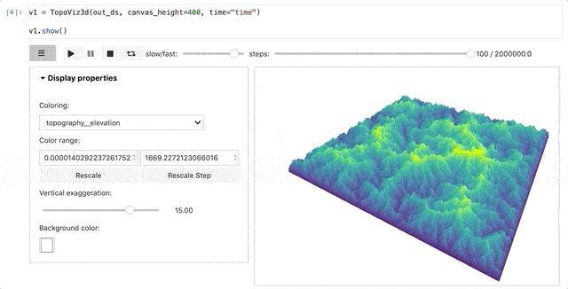
TopoViz3d: Paraview-like 3D terrain visualization, with time player and dimension explorer
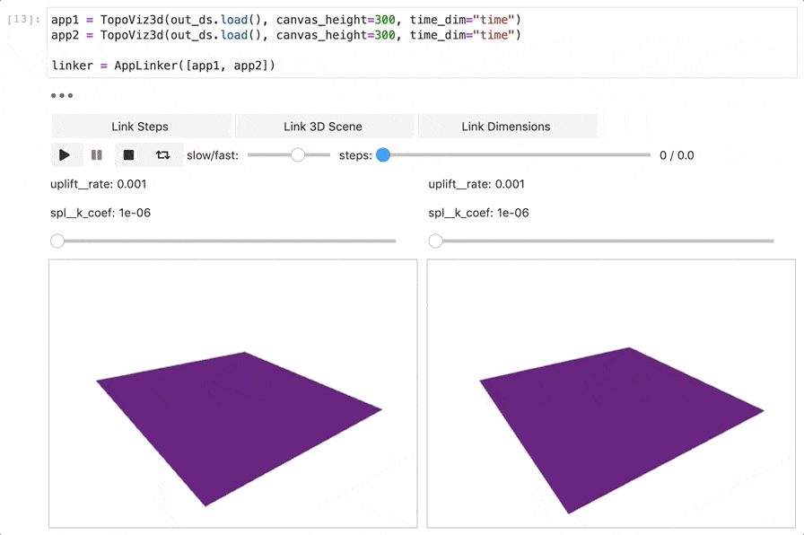
AppLinker: Easily link different application instances for, e.g., side-by-side comparison
Installation
You can install ipyfastscape either with conda:
$ conda install ipyfastscape -c conda-forge
or using pip:
$ python -m pip install ipyfastscape
Release history Release notifications | RSS feed


Download files
Download the file for your platform. If you're not sure which to choose, learn more about installing packages.
Source Distribution
Built Distribution
Filter files by name, interpreter, ABI, and platform.
If you're not sure about the file name format, learn more about wheel file names.
Copy a direct link to the current filters
File details
Details for the file ipyfastscape-0.2.1.tar.gz.
File metadata
- Download URL: ipyfastscape-0.2.1.tar.gz
- Upload date:
- Size: 18.5 kB
- Tags: Source
- Uploaded using Trusted Publishing? Yes
- Uploaded via: twine/4.0.2 CPython/3.11.5
File hashes
| Algorithm | Hash digest | |
|---|---|---|
| SHA256 |
b5d5c18b18a4495a2fcac2f36a2048a955a99f0f51539cb439605a128df77974
|
|
| MD5 |
9711812e4efa1593a41f097a1b480e58
|
|
| BLAKE2b-256 |
4a732c87a9325c8646ef012c5196f1a7983d5be6469fa845602c8a60b57f6deb
|
File details
Details for the file ipyfastscape-0.2.1-py3-none-any.whl.
File metadata
- Download URL: ipyfastscape-0.2.1-py3-none-any.whl
- Upload date:
- Size: 17.7 kB
- Tags: Python 3
- Uploaded using Trusted Publishing? Yes
- Uploaded via: twine/4.0.2 CPython/3.11.5
File hashes
| Algorithm | Hash digest | |
|---|---|---|
| SHA256 |
682ab374cd6d7613e90e7a5b4847e118ff744278d9fc8ac53fb3d08b40f2f7de
|
|
| MD5 |
01cbb1f2b34a5a59650a5b4b1903edef
|
|
| BLAKE2b-256 |
38ae59a604f25a3e45f160d72c4d6ba2a841a0cded6fb2a9462805baadba9861
|


