
mappyfile-geojson


A mappyfile plugin to convert GeoJSON to inline Mapfile features. Useful for adding dynamically created features (from web services, user created features), to a map.
import mappyfile
import mappyfile_geojson
# will soon be available to import as
# from mappyfile.plugins import geojson as mgeojson

gj = geojson.load(fn)
l = mappyfile_geojson.convert(gj)
print(mappyfile.dumps(l))
Converts:
{
  "type": "Feature",
  "geometry": {
    "type": "LineString",
    "coordinates": [
      [ 102.0, 0.0 ],
      [ 103.0, 1.0 ],
      [ 104.0, 0.0 ],
      [ 105.0, 1.0 ]
    ]
  },
  "properties": {
    "prop0": "value0",
    "prop1": 0.0
  }
}
to:
LAYER
    EXTENT 102.0 0.0 105.0 1.0
    STATUS ON
    TYPE LINE
    PROCESSING "ITEMS=prop0,prop1"
    FEATURE
        ITEMS "value0;0.0"
        POINTS
            102.0 0.0
            103.0 1.0
            104.0 0.0
            105.0 1.0
        END
    END
END
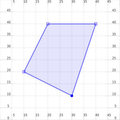
Demo
An example of using the plugin with mappyfile can be found in example.py.
Requirements
Python 2.7 or Python 3.x
Installation
pip install mappyfile-geojsonNotes
Can calculate extent of input features, with optional buffer
Multipart features currently not implemented
Nested properties are not supported
"properties": {
    "prop0": "value0",
    "prop1": { "this": "that" }
}
Will become:
ITEMS "value0;{u'this': u'that'}"
1 maintainer

Metadata
1 maintainer
Release files for mappyfile-geojson 0.1.2
For a detailed explanation of source distributions (sdists) and built distributions (wheels), please see the package formats documentation.
Built distribution (wheel)
| File | Interpreter | ABI | Platform | Reset |
|---|---|---|---|---|
| mappyfile_geojson-0.1.2-py2.py3-none-any.whl | Python 2, Python 3 | none | any | Details |
Release files / mappyfile_geojson-0.1.2-py2.py3-none-any.whl
| Download URL | mappyfile_geojson-0.1.2-py2.py3-none-any.whl |
|---|---|
| Size | 6.7 kB |
| Tags | Python 2 Python 3 |
|
SHA-256 checksum How to use checksums |
3b8c51a8da30f894d88e387281445d1a10fe7765af7aef378ef5ea9337dd98e8
|
|
BLAKE2b-256 checksum How to use checksums |
d8398b3f3883e714819da41fd0cbb41d8e26ea01b844b16219473bfc6b875ee3
|
| Upload date | |
|
Uploaded using Trusted Publishing? What is trusted publishing? |
No |
Security for mappyfile-geojson 0.1.2
Provenance
Provenance describes where a file came from. On PyPI, provenance is shared via attestations, which provide a verifiable record of the build or publishing details. View details, limitations and caveats.
No provenance found
None of the files in this release were uploaded with provenance metadata.
A note on package security
PyPI is a repository for distributing packages, not a service for auditing them. While third-party security researchers and our staff do their best to detect and remove malicious packages, PyPI cannot guarantee the quality, security or suitability of any given package.
To learn more about protecting yourself from malicious actors, visit our package security documentation.














