
mapsql-mcp
Ask your PostGIS or Oracle Spatial database questions in plain English and get the answer back as a map.
mapsql-mcp is a Model Context Protocol server that lets AI assistants
(Claude Desktop, Claude Code, Cursor, and any other MCP client) explore, query and analyse a PostGIS or an
Oracle Spatial (SDO_GEOMETRY) database safely and answer with maps rendered right in the chat.





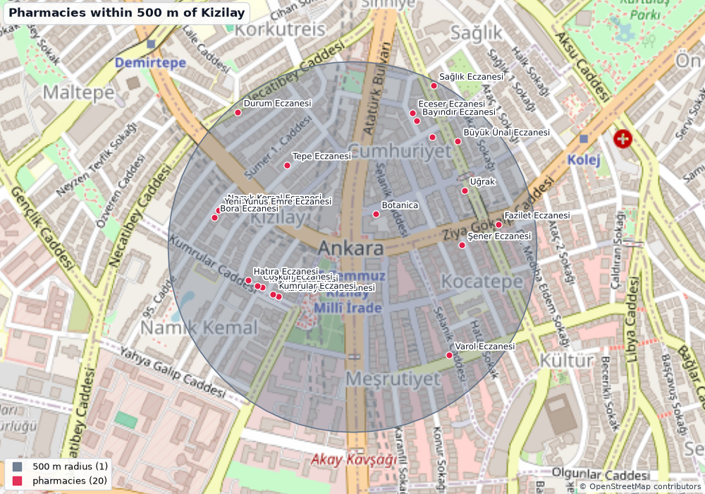
"Which pharmacies are within 500 m of Kızılay square?" - the model discovers the layers, calls
within_distance(geodesic metres, whatever the table's SRID), thenrender_map. The picture above is the literal output of those two tool calls on the bundled demo database.
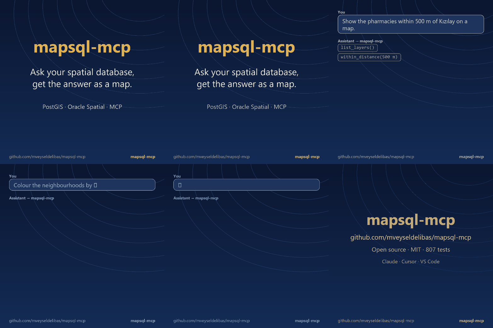
The GIF is built by scripts/make_demo_video.py from real tool outputs on the demo databases (PostGIS and Oracle).
Türkçe: kullanım kılavuzu aşağıda · Who is it for / step-by-step: Usage
Why another PostGIS / Postgres / Oracle MCP server?
Generic Postgres or Oracle MCP servers are not spatial-aware: the model has to hand-write PostGIS / SDO_* SQL and gets
SRIDs, geography casts, units and ST_DWithin / SDO_WITHIN_DISTANCE arguments wrong in subtle ways, then cannot show
the result. mapsql-mcp is built
around three ideas:
- Safe by construction. Every query is parsed (PostgreSQL: the real PostgreSQL parser; Oracle:
sqlglotin Oracle mode), runs in aREAD ONLYtransaction with a timeout and a row cap, and secrets never reach the model. Writes are off unless you ask for them (PostGIS only). - Spatial tools instead of SQL guessing.
within_distance,nearest,buffer,spatial_filter,spatial_join,aggregate,bbox_of... take care of SRIDs, metric units and indexes - the same 14 tools on both databases. Plainrun_sqlis still there. - Answers are maps.
render_mapreturns a PNG (OpenStreetMap basemap, choropleths, labels) as MCP image content and can also write an interactive Leaflet HTML file.
And the model is told to ask instead of guess: the server instructions, a prompt and the tools themselves refuse to proceed on "pharmacies nearby" (nearby what?) or on a place name that matches ten features.
Quickstart
Requires Python 3.10+ and a PostGIS or Oracle Spatial database. Use a read-only database role / user (see SECURITY.md). The backend is chosen from the connection string.
pip install mapsql-mcp            # or: pipx install mapsql-mcp   |   uvx mapsql-mcp
export DATABASE_URL=postgresql://readonly:secret@localhost:5432/gis
mapsql-mcp --check                # prints PostgreSQL/PostGIS versions and exits

# Oracle Spatial instead (python-oracledb thin mode: no Oracle Client install needed) - see "Oracle Spatial" below
pip install "mapsql-mcp[oracle]"
export DATABASE_URL="oracle://MAPSQL_RO:secret@dbhost:1521/ORCLPDB1"
mapsql-mcp --check
Claude Desktop
Edit claude_desktop_config.json (macOS ~/Library/Application Support/Claude/, Windows %APPDATA%\Claude\):
{
  "mcpServers": {
    "postgis": {
      "command": "uvx",
      "args": ["mapsql-mcp"],
      "env": { "DATABASE_URL": "postgresql://readonly:secret@localhost:5432/gis" }
    }
  }
}
Claude Code
claude mcp add postgis -e DATABASE_URL=postgresql://readonly:secret@localhost:5432/gis -- uvx mapsql-mcp
Cursor (.cursor/mcp.json) / Windsurf
{
  "mcpServers": {
    "postgis": {
      "command": "uvx",
      "args": ["mapsql-mcp", "--schemas", "public,osm"],
      "env": { "DATABASE_URL": "postgresql://readonly:secret@localhost:5432/gis" }
    }
  }
}
VS Code (.vscode/mcp.json, Copilot Chat in Agent mode)
VS Code uses a servers key and can prompt for the password instead of storing it in the file:
{
  "inputs": [
    { "id": "pg-url", "type": "promptString", "description": "PostGIS connection URL", "password": true }
  ],
  "servers": {
    "postgis": {
      "type": "stdio",
      "command": "uvx",
      "args": ["mapsql-mcp", "--schemas", "public,osm"],
      "env": { "DATABASE_URL": "${input:pg-url}" }
    }
  }
}
Other MCP clients (ChatGPT-compatible, remote)
Run the streamable-HTTP transport and point the client at http://127.0.0.1:8000/mcp:
mapsql-mcp --transport streamable-http --host 127.0.0.1 --port 8000
There is no authentication on the HTTP transport: keep it on loopback or put it behind your own authenticating
reverse proxy / tunnel. If you installed from a clone use "command": "python", "args": ["-m", "mapsql_mcp"].
Usage, step by step
Who it is for. GIS developers, database people, analysts and researchers who already use an AI assistant (Claude Code, Claude Desktop, Cursor, VS Code + Copilot) and have spatial data in PostGIS or Oracle Spatial. It is a building block for an assistant, not an end-user app: there is no web UI of its own, the chat window is the UI.
1. Install:
pipx install "mapsql-mcp[oracle]" # or: pip install "mapsql-mcp[oracle]"
2. Point it at a database with a read-only user and check the connection:
export DATABASE_URL=postgresql://readonly:secret@localhost:5432/gis      # or oracle://USER:PASS@host:1521/service
mapsql-mcp --check
No database at hand? Build the bundled demo (Natural Earth + OpenStreetMap Ankara) in two minutes, see the next section.
3. Register it with your assistant. Put one of the JSON blocks from Quickstart into the client's config
(.mcp.json for Claude Code, .vscode/mcp.json for VS Code, .cursor/mcp.json for Cursor, claude_desktop_config.json
for Claude Desktop). In VS Code click Start above the server entry; in Claude Code run /mcp and check it says
connected. You should see 14 tools.
4. Ask in plain language. For example:
- "What layers do you have? Summarise them."
- "Which pharmacies are within 500 m of Kızılay (39.9208, 32.8541)? Show them on a map."
- "Which neighbourhood has the most cafes? Colour the neighbourhoods by count."
- "The 5 hospitals nearest to this point, with distances."
- "Find the pharmacies nearby." - a good assistant asks nearby what? instead of guessing.
5. See the map. render_map returns the PNG to the assistant and saves it (and optionally an interactive Leaflet HTML)
under ~/mapsql-mcp-output. Some clients (e.g. the Claude Code panel in VS Code) do not show tool images to you; add
MAPSQL_OPEN_MAPS=1 (or --open-maps) to the server's env and every map opens in your default viewer.
Good to know. The assistant's provider (Anthropic, OpenAI, ...) receives the rows the tools return, so do not connect
databases whose content must not leave your organisation; use --schemas / --layers to expose only what is needed, and
keep the database user read-only.
Try it with the demo database (2 minutes)
The demo data is Natural Earth (world countries, provinces, cities, rivers, lakes - public domain) plus an OpenStreetMap
extract of central Ankara (POIs, roads, parks, 105 neighbourhoods - ODbL). A pinned snapshot ships in demo/data (2.8 MB),
so building it works offline.
docker run -d --name pg -p 55432:5432 -e POSTGRES_PASSWORD=pw postgis/postgis:16-3.4
pip install -e .
python demo/build_demo_db.py --database-url postgresql://postgres:pw@localhost:55432/postgres
export DATABASE_URL=postgresql://postgres:pw@localhost:55432/postgres
Then ask your assistant, for example:
- "What layers do you have? Summarise the Ankara data."
- "Which neighbourhood has the most pharmacies? Show it as a map."
- "Cafes within 300 m of Kızılay (lat 39.9208, lon 32.8541), on a map."
- "Find the pharmacies nearby." → it should ask where.
Cafes per neighbourhood (spatial_join + choropleth) |
5 nearest hospitals (nearest) |
|---|---|
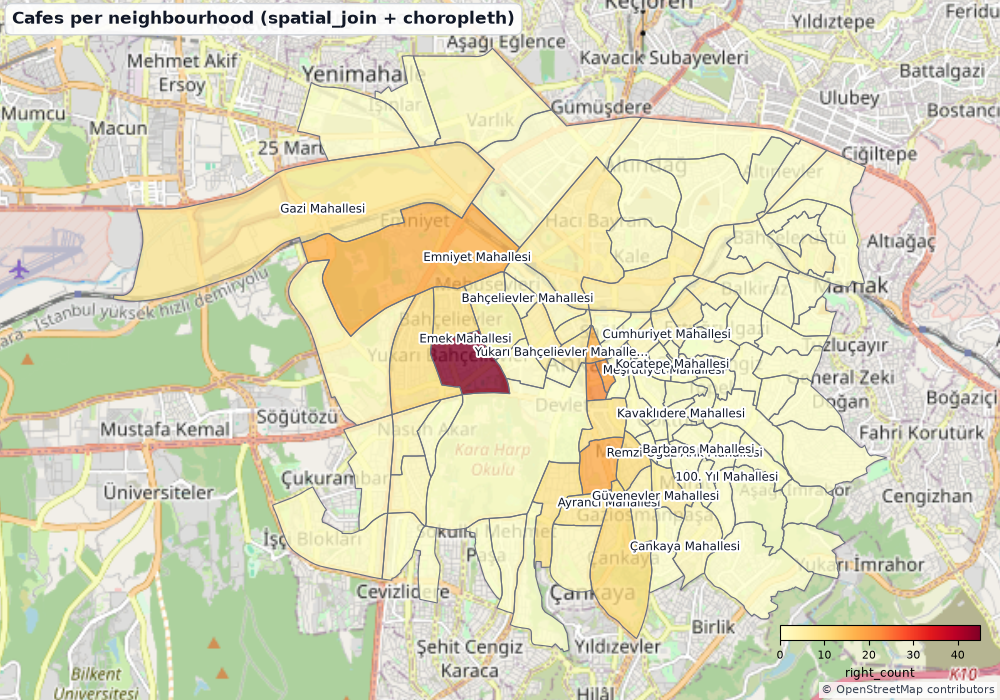 |
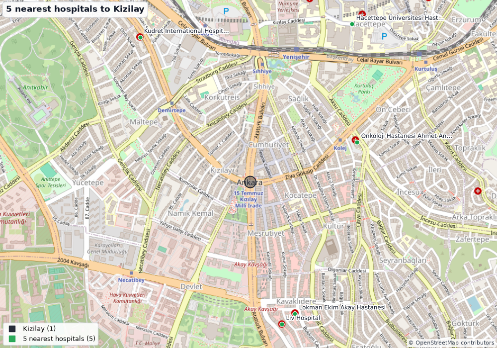 |
Map data © OpenStreetMap contributors (ODbL). Interactive versions of two of them: docs/images/*.html (open in a browser).
Oracle Spatial
New in v0.2: the same tools, the same safety model and the same maps on Oracle Database with Spatial (19c, 21c, 23ai /
26ai, Autonomous Database, ...), through python-oracledb in thin mode (no Oracle Client libraries needed).
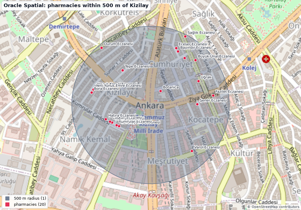
Same question, same answer (20 pharmacies) as on PostGIS - this time from SDO_WITHIN_DISTANCE(... 'distance=500 unit=M')
on an Autonomous Database. Map data (c) OpenStreetMap contributors (ODbL).
Install and connect
pip install "mapsql-mcp[oracle]" # adds oracledb + sqlglot
| Variable | Meaning |
|---|---|
DATABASE_URL=oracle://USER:PASS@host:1521/service_name |
Easy form. Percent-encode special characters in the password (@ -> %40). Add ?protocol=tcps (or ?tls=true) for TLS; other ?key=value pairs are passed on as Easy Connect parameters (e.g. ssl_server_dn_match=yes). |
MAPSQL_ORACLE_DSN + MAPSQL_ORACLE_USER + MAPSQL_ORACLE_PASSWORD |
For long TNS descriptors, tcps://host:1522/service strings or tnsnames.ora aliases (with TNS_ADMIN). The DSN overrides the host part of an oracle:// URL; user/password given here override those in the URL. Keeping the password out of the URL avoids quoting problems. |
MAPSQL_ORACLE_WALLET_DIR, MAPSQL_ORACLE_WALLET_PASSWORD |
Only for mutual-TLS (wallet) connections, e.g. Autonomous Database with "mTLS required". |
MAPSQL_BACKEND=postgis|oracle / --backend |
Force the backend. Default: detected from the DATABASE_URL scheme, or Oracle when only MAPSQL_ORACLE_DSN is set. |
All other settings (MAPSQL_SCHEMAS, MAPSQL_LAYERS, MAPSQL_STATEMENT_TIMEOUT_MS, MAPSQL_MAX_ROWS, ...) work unchanged;
the timeout is applied as the connection call_timeout, schemas are Oracle owners.
Autonomous Database (TLS, no wallet). In the console open Database connection, choose TLS authentication: TLS (instead
of mTLS; requires an access control list / allowed IPs for your address) and copy the Low/Medium connection string. The
descriptor looks like (description=(address=(protocol=tcps)(port=1522)(host=...))(connect_data=(service_name=...))(security=(ssl_server_dn_match=yes)));
put it in MAPSQL_ORACLE_DSN (it is long and contains parentheses, so it does not fit well in a URL). The server certificate is
verified against the operating system's trust store. Use a dedicated read-only user, never ADMIN.
export MAPSQL_ORACLE_DSN='(description=(retry_count=3)(address=(protocol=tcps)(port=1522)(host=adb.<region>.oraclecloud.com))(connect_data=(service_name=xxxx_mydb_low.adb.oraclecloud.com))(security=(ssl_server_dn_match=yes)))'
export MAPSQL_ORACLE_USER=MAPSQL_RO MAPSQL_ORACLE_PASSWORD='...'
mapsql-mcp --check
Read-only user
scripts/oracle_readonly_user.sql is the Oracle counterpart of readonly_role.sql: a user with
only CREATE SESSION plus SELECT on the tables the assistant may see. The spatial metadata views, MDSYS.CS_SRS and the
SDO_* operators are available to every user, so nothing else is needed.
Claude Desktop / Claude Code / Cursor / VS Code
{
  "mcpServers": {
    "oracle-spatial": {
      "command": "uvx",
      "args": ["--from", "mapsql-mcp[oracle]", "mapsql-mcp", "--schemas", "GIS"],
      "env": { "DATABASE_URL": "oracle://MAPSQL_RO:secret@dbhost:1521/ORCLPDB1" }
    }
  }
}
claude mcp add oracle-spatial -e DATABASE_URL=oracle://MAPSQL_RO:secret@dbhost:1521/ORCLPDB1 -- uvx --from "mapsql-mcp[oracle]" mapsql-mcp --schemas GIS
VS Code (.vscode/mcp.json) - the password is prompted for and never stored in the file; a TNS descriptor goes into MAPSQL_ORACLE_DSN:
{
  "inputs": [
    { "id": "ora-pw", "type": "promptString", "description": "Oracle password for MAPSQL_RO", "password": true }
  ],
  "servers": {
    "oracle-spatial": {
      "type": "stdio",
      "command": "uvx",
      "args": ["--from", "mapsql-mcp[oracle]", "mapsql-mcp", "--schemas", "GIS", "--no-basemap"],
      "env": {
        "MAPSQL_ORACLE_DSN": "dbhost:1521/ORCLPDB1",
        "MAPSQL_ORACLE_USER": "MAPSQL_RO",
        "MAPSQL_ORACLE_PASSWORD": "${input:ora-pw}"
      }
    }
  }
}
Oracle demo schema (3 minutes)
scripts/oracle_demo_db.py loads the same Natural Earth + OpenStreetMap-Ankara data as the PostGIS demo into the schema
MAPSQL_DEMO (WORLD_COUNTRIES, WORLD_CITIES, ANKARA_POIS, ANKARA_NEIGHBOURHOODS, ... - Oracle has no schemas-within-a-database
convention like world.countries, so the PostGIS schema becomes a table-name prefix), registers USER_SDO_GEOM_METADATA, builds spatial indexes,
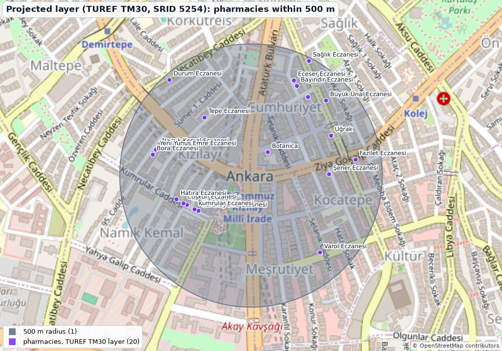
adds TUREF TM30 (EPSG:5254, metres) copies of two Ankara layers to exercise projected coordinate systems, and creates the
read-only user MAPSQL_RO. It needs an administrator login in a git-ignored ini file:
; oracle-test.ini
[oracle]
user = ADMIN
password = ...
dsn = (description=...)    ; or host:1521/service
python scripts/oracle_demo_db.py          # creates MAPSQL_DEMO + MAPSQL_RO (random passwords are written to the same ini file)
python scripts/make_oracle_demo_maps.py --ini oracle-test.ini     # the maps in docs/images/oracle_*.png
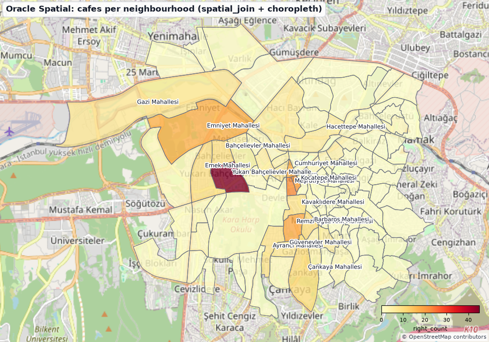
Cafes per neighbourhood (spatial_join + choropleth) |
Projected layer: TUREF TM30, SRID 5254 |
|---|---|
 |
 |
How the tools map to Oracle Spatial
| Tool | Oracle implementation |
|---|---|
list_layers / describe_layer |
ALL_SDO_GEOM_METADATA (+ unregistered SDO_GEOMETRY columns of accessible tables/views), SRID, tolerance, geometry type from SDO_GTYPE, spatial-index presence/validity from ALL_INDEXES, CRS kind/name from MDSYS.SDO_COORD_REF_SYS / CS_SRS |
within_distance |
SDO_WITHIN_DISTANCE(geom, ref, 'distance=N unit=M'), distance via SDO_GEOM.SDO_DISTANCE(..., 'unit=M') |
nearest |
SDO_NN + SDO_NN_DISTANCE (sdo_batch_size when attribute filters are present, so the filter is applied while neighbours stream out) |
buffer |
SDO_GEOM.SDO_BUFFER(..., 'unit=M arc_tolerance=...'), dissolve with SDO_AGGR_UNION, area with SDO_AREA(..., 'unit=SQ_KM') |
spatial_filter / spatial_join |
SDO_RELATE masks (ANYINTERACT, INSIDE+COVEREDBY+EQUAL, CONTAINS+COVERS+EQUAL, TOUCH, OVERLAPBDYDISJOINT+OVERLAPBDYINTERSECT), SDO_WITHIN_DISTANCE for dwithin; joins run as a set-based spatial join grouped by ROWID |
bbox_of |
SDO_AGGR_MBR over SDO_CS.TRANSFORM(geom, 4326) |
aggregate |
SDO_GEOM.SDO_AREA(... 'unit=SQ_KM') / SDO_LENGTH(... 'unit=KM') |
| GeoJSON | SDO_UTIL.TO_GEOJSON on geometries transformed with SDO_CS.TRANSFORM(geom, 4326); simplified/rounded in Python |
run_sql |
guarded Oracle SQL; every SDO_GEOMETRY column is returned as GeoJSON (WGS84) |
Metres are right on geodetic layers (EPSG:4326 and Oracle's legacy 8307: geodesic on the ellipsoid) and projected layers
(planar in the projection, converted with unit=M). Values are always bind variables; identifiers come from the catalog.
Differences from PostGIS to know about
- Spatial index required for
SDO_*operators. Layers without a valid spatial index are queried with index-freeSDO_GEOM.*functions (flagged in the response, anddescribe_layerwarns). Create indexes (CREATE INDEX ... INDEXTYPE IS MDSYS.SPATIAL_INDEX_V2) and register the layer inUSER_SDO_GEOM_METADATAfor speed. crosseshas no faithful Oracle mask:spatial_filterrefuses it with an explanation instead of returning a possibly wrong answer (useintersects/touches/overlaps, orrun_sqlwith your ownSDO_RELATEmask).within/containsinclude boundary contact (COVEREDBY/COVERS) andEQUAL;overlapsisOVERLAPBDYDISJOINT+OVERLAPBDYINTERSECT.- Write mode is not available on Oracle in this version (
--allow-writeis refused at start-up). - Identifiers are shown in lower case (
mapsql_demo.ankara_pois, columnname) when they are plain upper-case Oracle names; they remain valid unquoted in SQL. Quoted mixed-case names are shown as they are and must be quoted inrun_sql. - Oracle stores the empty string as
NULL.EQ ''filters are translated toIS NULL. - Small numeric differences to PostGIS (checked on the demo data): distances within 0.1 m for geodetic layers; areas/lengths within
about 0.01 %;
dwithinjoins on polygons can differ by a feature at the boundary; a buffer's area differs by its polygon approximation. On a projected layer distances are planar in that projection (TM30 is within about 1 m per kilometre of geodesic distances near the central meridian). - GeoJSON conversion does not support circular arcs / compound curves (buffers of projected data are densified first); a geometry that Oracle cannot serialise makes the tool fail with an explicit database error.
list_layersreports extents withSDO_AGGR_MBR(skipped for layers over 500 000 rows);SDO_TUNE.EXTENT_OFcannot run inside aREAD ONLYtransaction.
Tools
| Tool | What it does |
|---|---|
server_info |
Database / PostGIS or Oracle Spatial versions, backend, mode, limits, allowlists |
list_layers |
Spatial layers with geometry type, SRID, row estimate, extent, columns (searchable) |
describe_layer |
Columns/types, exact count and extent, top values of text columns, numeric ranges |
sample_features |
A few real features |
find_features |
Attribute filters (= != < > like ilike contains in between is_null ...), ordering, column selection |
within_distance |
Features within N metres of a lon/lat or of other features; geodesic for lon/lat data, planar for metric CRSs, converted for feet etc.; adds distance_m |
nearest |
k nearest neighbours with distance_m (GiST KNN pre-selection on large tables) |
buffer |
Geodesic buffer of a point or a (filtered) layer, optionally dissolved, with area_km2 |
spatial_filter |
intersects / within / contains / touches / crosses / overlaps / disjoint vs another layer, a bbox or a GeoJSON geometry |
aggregate |
count, count_distinct, sum, avg, min, max, geodesic area_km2 / length_km, grouped |
spatial_join |
Per left feature: count / sum / avg / attach of related right features (intersects, within, contains, dwithin) |
bbox_of |
Bounding box and centre of a layer or subset |
run_sql |
Guarded read-only SQL (PostgreSQL or Oracle dialect); geometry columns come back as GeoJSON |
render_map |
PNG map as MCP image content (+ saved file), optional Leaflet HTML; layers from result_ids, GeoJSON or SQL; labels and choropleth (value_property) |
execute_sql |
Only with --allow-write, PostGIS only: one INSERT / UPDATE / DELETE (WHERE required) / CREATE TABLE|INDEX|VIEW / ALTER TABLE ADD COLUMN |
All coordinates are WGS84 lon/lat; distances are metres; areas km². Every geometry-returning tool stores the full
(simplified) result server-side and returns a result_id, so render_map(result_ids=[...]) never needs the model to copy
big GeoJSON around. Responses stay small: geometries above a vertex budget are returned as representative points
(with a note) unless you ask for geometry="full".
Prompts: gis_assistant, spatial_question, explore_database. Resources: mapsql://guide, mapsql://layers.
Ask, don't guess
within_distance with no point and no reference feature does not guess a location; it fails with
"Missing reference: near WHAT? ... ask them". A reference that matches several features returns the candidates and asks
which one is meant. Likewise a missing distance, an ambiguous layer name, a numeric filter given text, swapped lon/lat ...
The server instructions (sent on connect) tell the model to ask one short clarifying question first. This was motivated by
the author's TR-CBS-Komut benchmark, where models differed from 0% to 98% in recognising missing information.
Safety model
Defence in depth - no single layer is trusted (SECURITY.md has the full threat model):
| Layer | What it does |
|---|---|
| SQL parsing | PostgreSQL: pglast (the actual PostgreSQL parser). Oracle: sqlglot (Oracle dialect) plus an independent token pass - exactly one statement, plain SELECT/WITH/set operations only; rejects DML/DDL/MERGE, PL/SQL blocks, EXECUTE IMMEDIATE, FOR UPDATE, database links (@), DBMS_*/UTL_*/CTX_* packages, SYS/DBA_*/V$* objects, sequences, URL/XML functions; anything unparseable is refused (see SECURITY.md). PostgreSQL details: Exactly one statement, and it must be a plain SELECT (CTEs/UNION/VALUES fine). Rejects DDL/DML/COPY/DO/SET/transaction control, SELECT INTO, FOR UPDATE, data-modifying CTEs, pg_read_file, lo_*, dblink*, pg_sleep, set_config, nextval, query_to_xml, all pg_* functions except a small harmless list, and credential/activity relations (pg_authid, pg_shadow, pg_stat_activity, pg_settings ...). 540+ test cases. |
| READ ONLY transaction | PostgreSQL: every query runs in BEGIN READ ONLY with statement_timeout, lock_timeout, always rolled back; a SELECT my_volatile_function() that tries to INSERT is stopped by PostgreSQL (tested). Oracle: SET TRANSACTION READ ONLY plus call_timeout, always rolled back (ORA-01456 for writes, tested with a write-capable user). |
| Row caps | Server-side cursor / FETCH FIRST + hard cap (MAPSQL_MAX_ROWS, default 5000); the server never materialises a huge result. |
| Allowlists | --schemas public,osm and/or --layers 'osm.*,public.cities': hidden everywhere (catalog tools, SQL guard, search_path). |
| No secrets in output | Errors are rewritten to the primary message; DSNs, passwords and hosts are scrubbed; the connection string is never returned. |
| Writes off by default | --allow-write adds one separate tool with a much narrower guard (no DROP/TRUNCATE/GRANT, no UPDATE/DELETE without WHERE). |
| Your database role | The strongest layer: connect with a role/user that only has SELECT on what the assistant may see (scripts/readonly_role.sql, scripts/oracle_readonly_user.sql). |
Configuration
| Env var | CLI flag | Default | Meaning |
|---|---|---|---|
DATABASE_URL |
(--database-url, avoid) |
required | postgresql://... or oracle://USER:PASS@host:1521/service_name |
MAPSQL_ORACLE_DSN, MAPSQL_ORACLE_USER, MAPSQL_ORACLE_PASSWORD |
Oracle: DSN / TNS descriptor and credentials (alternative to the URL) | ||
MAPSQL_ORACLE_WALLET_DIR, MAPSQL_ORACLE_WALLET_PASSWORD |
Oracle: mTLS wallet (optional) | ||
MAPSQL_BACKEND |
--backend |
auto | postgis or oracle |
MAPSQL_SCHEMAS |
--schemas |
all | Comma-separated schema allowlist (Oracle: owners) |
MAPSQL_LAYERS |
--layers |
all | Comma-separated table/layer patterns (schema.table, schema.*, table) |
MAPSQL_STATEMENT_TIMEOUT_MS |
--statement-timeout-ms |
15000 | Per-query timeout |
MAPSQL_MAX_ROWS / MAPSQL_DEFAULT_LIMIT |
--max-rows |
5000 / 100 | Hard row cap / default limit |
MAPSQL_ALLOW_WRITE |
--allow-write |
off | Enable execute_sql (PostGIS only) |
MAPSQL_BASEMAP |
--no-basemap |
osm |
osm, none, or a tile URL template with {z}/{x}/{y} |
MAPSQL_OUTPUT_DIR |
--output-dir |
~/mapsql-mcp-output |
Where render_map saves PNG/HTML (+ tile cache) |
MAPSQL_OPEN_MAPS |
--open-maps |
off | Open each rendered map in the default viewer (local use; for clients such as the Claude Code VS Code panel that do not display tool images) |
MAPSQL_LOG_LEVEL |
WARNING |
Logs go to stderr only |
Basemap tiles come from tile.openstreetmap.org with attribution, a descriptive User-Agent, a ≤ 16-tile cap per map and
an on-disk cache. Please respect the OSM tile usage policy; for
heavy use point MAPSQL_BASEMAP at your own tile server, or use none (works fully offline).
Benchmark: mapsql-bench
bench/ ships 60 English GIS questions over the demo database (52 answerable + 8 that must be
answered with a clarifying question), in 8 categories (attribute, distance, spatial, aggregate, join, buffer, bbox,
ambiguous), with gold answers computed by hand-written SQL, and a runner that evaluates any OpenAI-compatible model
(OpenAI, OpenRouter, vLLM, Ollama, LM Studio ...) in an agent loop that calls this server's tools over stdio:
python bench/run_bench.py --oracle                  # no LLM: replays one reference tool call per question
python bench/run_bench.py --validate-gold           # re-checks gold answers against the database
python bench/run_bench.py --model gpt-4o-mini --api-key-env OPENAI_API_KEY
python bench/run_bench.py --model qwen2.5:7b --base-url http://localhost:11434/v1
Scoring: numbers within a tolerance, names as case/accent-insensitive sets, and for ambiguous questions the model must
end with CLARIFY: instead of ANSWER:. What is verified today (v0.1): the gold answers match the database (52/52) and the
toolset can express every answerable question (oracle 52/52). No LLM results are published yet - the harness is
ready; PRs adding model results to bench/RESULTS.md are very welcome.
Limitations (v0.2)
- PostGIS or Oracle Spatial (one database per server);
geometry/geographycolumns (PostGIS) orSDO_GEOMETRYcolumns (Oracle) of tables, views, materialised views, foreign tables. Oracle specifics: see Differences from PostGIS (read-only only, nocrosses, index-free fallback). - No raster, topology or 3D support in the structured tools (
run_sqlcan still query them). - The basemap needs internet (graceful fallback to a plain background) and supports OSM-style raster tiles only.
render_mapdraws one flat colour per layer, plus a single-variable choropleth; no custom styling yet.- The HTTP transport has no auth;
execute_sqlis a deliberately small write surface. - Cross-CRS joins transform the left geometry; very large cross-SRID
dwithinjoins can be slow. - Tested against PostgreSQL 18 / PostGIS 3.6 and Oracle Database 26ai (23.26, Spatial 23.7, Autonomous Database Always Free) with
mcp1.30 and 2.3 (the code supports both SDK generations); CI runs PostGIS 3.4 / PostgreSQL 16 and the Oracle guard tests (the database-backed Oracle tests skip without credentials).
Roadmap
- v0.3: Oracle write mode (narrow guard), Oracle
SDO_JOIN/Spatial Studio extras, auth for HTTP (bearer tokens), per-tool allowlists, vector-tile/PMTiles basemaps, raster/H3 summaries, anexplaintool, routing helpers (pgRouting), result export (GeoJSON/GeoPackage), richer map styling - v0.4: multi-database profiles, MCP elicitation for clarifying questions (instead of plain-text asks), catalog caching knobs
- Published benchmark results for popular models + a public leaderboard
Development
python -m venv .venv && .venv/bin/pip install -e ".[dev]"
# a throwaway PostGIS (never point the tests at a database you care about):
docker run -d -p 55432:5432 -e POSTGRES_PASSWORD=pw -e POSTGRES_DB=mapsql_test postgis/postgis:16-3.4
export MAPSQL_TEST_DATABASE_URL=postgresql://postgres:pw@localhost:55432/mapsql_test
pytest                      # guard tests need no database; the rest recreate schemas `mt` and `mt_other`
Oracle tests (pytest -m oracle) run when oracle-test.ini ([oracle_ro], see above) or MAPSQL_TEST_ORACLE_URL /
MAPSQL_TEST_ORACLE_DSN+_USER+_PASSWORD is available and scripts/oracle_demo_db.py has been run; otherwise they are skipped. The
Oracle SQL guard tests need no database.
See CONTRIBUTING.md. Windows helper for a local cluster: scripts/dev_cluster.ps1.
Türkçe
mapsql-mcp, yapay zekâ asistanlarının (Claude Desktop/Code, Cursor, ChatGPT uyumlu MCP istemcileri) bir PostGIS veya Oracle Spatial (v0.2) veritabanını güvenli biçimde sorgulamasını, mekânsal analiz yapmasını ve cevabı harita olarak sohbette göstermesini sağlayan açık kaynaklı bir MCP sunucusudur.
- Güvenlik önce: her sorgu gerçek PostgreSQL ayrıştırıcısı (
pglast) ile doğrulanır; tekSELECT,READ ONLYişlem, zaman aşımı ve satır sınırı.pg_read_file,COPY,dblink,lo_*vb. engellidir. Yazma varsayılan olarak kapalıdır (--allow-write). Şema/katman izin listesi (--schemas,--layers) desteklenir; parola ve bağlantı dizesi çıktıya sızmaz. - Mekânsal araçlar:
list_layers,describe_layer,within_distance(metre cinsinden, SRID'den bağımsız),nearest,buffer,spatial_filter,aggregate,spatial_join,bbox_of,run_sqlverender_map(OSM altlıklı PNG + isteğe bağlı etkileşimli Leaflet HTML, kloropet harita). - Belirsizse sorar: "yakındaki eczaneler" gibi eksik bilgili sorularda model tahmin yürütmek yerine "neye yakın?" diye sorar (araçlar da eksik girdiyi reddeder). Bu, yazarın TR-CBS-Komut kıyaslamasından çıkan bir derstir.
- Kıyaslama:
bench/altında demo veritabanı üzerinde 60 İngilizce CBS sorusu (8'i "sormalı" tipi), altın cevaplar ve herhangi bir OpenAI uyumlu modeli deneyen çalıştırıcı bulunur.
Oracle Spatial: pip install "mapsql-mcp[oracle]" ve DATABASE_URL=oracle://KULLANICI:SIFRE@sunucu:1521/servis_adi
(uzun TNS tanımlayıcıları için MAPSQL_ORACLE_DSN + MAPSQL_ORACLE_USER + MAPSQL_ORACLE_PASSWORD). Aynı 14 araç; mesafeler
unit=M ile metre cinsinden, coğrafi (4326) ve projeksiyonlu (ör. TUREF TM30, EPSG:5254) katmanlarda doğrudur. Sorgular sqlglot
(Oracle lehçesi) ile doğrulanır, SET TRANSACTION READ ONLY ve salt okunur kullanıcı (scripts/oracle_readonly_user.sql) önerilir.
Ayrıntı: yukarıdaki Oracle Spatial bölümü.
Kimin için? Yapay zekâ asistanı (Claude Code, Claude Desktop, Cursor, VS Code + Copilot) kullanan ve mekânsal verisi PostGIS ya da Oracle Spatial'da duran CBS geliştiricileri, veritabanı uzmanları, analistler ve araştırmacılar için. Son kullanıcı uygulaması değildir; kendi ekranı yoktur, arayüzü sohbet penceresinin kendisidir.
Adım adım kullanım
1. Kurulum:
pipx install "mapsql-mcp[oracle]" # ya da: pip install "mapsql-mcp[oracle]"
2. Veritabanını salt okunur bir kullanıcıyla bağlayın ve bağlantıyı deneyin:
export DATABASE_URL=postgresql://salt_okunur:sifre@localhost:5432/cbs     # ya da oracle://KULLANICI:SIFRE@sunucu:1521/servis
mapsql-mcp --check
Salt okunur kullanıcı betikleri: scripts/readonly_role.sql (PostGIS), scripts/oracle_readonly_user.sql (Oracle).
Elinizde veritabanı yoksa yukarıdaki Try it with the demo database bölümüyle iki dakikada demo veritabanı kurulur
(Natural Earth + OpenStreetMap Ankara).
3. Asistana tanıtın. Quickstart bölümündeki JSON örneklerinden birini istemcinin ayar dosyasına koyun: Claude Code
için .mcp.json, VS Code için .vscode/mcp.json, Cursor için .cursor/mcp.json, Claude Desktop için
claude_desktop_config.json. VS Code'da sunucunun üstündeki Start'a basın; Claude Code'da /mcp yazıp
connected olduğunu görün. 14 araç listelenmelidir.
4. Türkçe sorun. Örnekler:
- "Hangi katmanlar var? Özetle."
- "Kızılay'a (39.9208, 32.8541) 500 m içindeki eczaneleri haritada göster."
- "En çok kafesi olan mahalle hangisi? Mahalleleri kafe sayısına göre renklendir."
- "Bu noktaya en yakın 5 hastaneyi mesafeleriyle listele."
- "Yakındaki eczaneleri bul." — iyi bir asistan tahmin etmez, "neye yakın?" diye sorar.
5. Haritayı görün. render_map haritayı asistana PNG olarak döner ve ~/mapsql-mcp-output klasörüne kaydeder
(istenirse etkileşimli Leaflet HTML de). Bazı istemciler (ör. VS Code'daki Claude Code paneli) aracın resmini size
göstermez; sunucunun env kısmına MAPSQL_OPEN_MAPS=1 (ya da --open-maps) ekleyin, her harita varsayılan
görüntüleyicide açılır.
Bilmeniz gereken. Asistanın sağlayıcısı (Anthropic, OpenAI vb.) araçların döndürdüğü satırları görür. Kurum dışına
çıkmaması gereken verinin bulunduğu veritabanlarını bağlamayın; --schemas / --layers ile yalnız gereken katmanları açın
ve veritabanı kullanıcısını salt okunur tutun. Demo veri: Natural Earth (kamu malı) ve OpenStreetMap (ODbL), ayrıntı:
demo/ATTRIBUTION.md.
Yazar: Mehmet Veysel Delibaş, CBS yazılım mühendisi (Türkiye).
License and attribution
Code: MIT © 2026 Mehmet Veysel Delibaş. Demo data: Natural Earth (public domain) and OpenStreetMap
(© OpenStreetMap contributors, ODbL); see demo/ATTRIBUTION.md.
Maps rendered with the OSM basemap carry the required attribution.
1 maintainer

Metadata
1 maintainer
Release files for mapsql-mcp 0.2.0
For a detailed explanation of source distributions (sdists) and built distributions (wheels), please see the package formats documentation.
Source distribution (sdist)
| File | Size | Uploaded | Provenance | Actions |
|---|---|---|---|---|
| mapsql_mcp-0.2.0.tar.gz | 132.7 kB | With provenance | Details for mapsql_mcp-0.2.0.tar.gz |
Built distribution (wheel)
| File | Interpreter | ABI | Platform | Actions Reset |
|---|---|---|---|---|
| mapsql_mcp-0.2.0-py3-none-any.whl | Python 3 | none | any | Details for mapsql_mcp-0.2.0-py3-none-any.whl |
Total release size: 232.5 kB
Release files / mapsql_mcp-0.2.0.tar.gz
| Download URL | mapsql_mcp-0.2.0.tar.gz |
|---|---|
| Size | 132.7 kB |
| Tags | Source |
|
SHA-256 checksum How to use checksums |
8f59dfd67580e998421b81528254913da6883087ed203d60e7da6c8d18acf2e7
|
|
BLAKE2b-256 checksum How to use checksums |
6e5e562b8ca84520e40f91b916f2bc5e6febfad6facb03d8b50dd2233d3d7d2c
|
| Upload date | |
|
Uploaded using Trusted Publishing? What is trusted publishing? |
Yes |
| Uploaded via |
twine/7.0.0 CPython/3.13.16
|
Provenance
Provenance describes where a file came from. On PyPI, provenance is shared via attestations, which provide a verifiable record of the build or publishing details. View details, limitations and caveats.


PyPI Publish Attestation
PyPI verified that this artifact, at this checksum, originated from the publisher listed below.
Signed by GitHub Actions, verified by PyPI on Nov 5, 2026.
Transparency logRelease files / mapsql_mcp-0.2.0-py3-none-any.whl
| Download URL | mapsql_mcp-0.2.0-py3-none-any.whl |
|---|---|
| Size | 99.9 kB |
| Tags | Python 3 |
|
SHA-256 checksum How to use checksums |
fb38cbe1a3e096ced5b9b0d6bd8bb74e85fb33f2da296f8a3b582f663eba004b
|
|
BLAKE2b-256 checksum How to use checksums |
ad16ac91ef533d2bd9e2097a0d297bae88f4751a8499e28bbc0cdcca13ffeab9
|
| Upload date | |
|
Uploaded using Trusted Publishing? What is trusted publishing? |
Yes |
| Uploaded via |
twine/7.0.0 CPython/3.13.16
|
Provenance
Provenance describes where a file came from. On PyPI, provenance is shared via attestations, which provide a verifiable record of the build or publishing details. View details, limitations and caveats.
PyPI Publish Attestation
PyPI verified that this artifact, at this checksum, originated from the publisher listed below.
Signed by GitHub Actions, verified by PyPI on Nov 5, 2026.
Transparency logSecurity for mapsql-mcp 0.2.0
Provenance
Provenance describes where a file came from. On PyPI, provenance is shared via attestations, which provide a verifiable record of the build or publishing details. View details, limitations and caveats.
Full provenance
All 2 files in this release have been uploaded with provenance metadata.
Attestation for mapsql_mcp-0.2.0.tar.gz
PyPI Publish Attestation
PyPI verified that this artifact, at this checksum, originated from the publisher listed below.
Signed by GitHub Actions, verified by PyPI on Nov 5, 2026.
Transparency logA note on package security
PyPI is a repository for distributing packages, not a service for auditing them. While third-party security researchers and our staff do their best to detect and remove malicious packages, PyPI cannot guarantee the quality, security or suitability of any given package.
To learn more about protecting yourself from malicious actors, visit our package security documentation.













