
This repository provides a tool to calculate the area of polygons in semantic segmentation data, specifically for images in YOLO format. It enables the precise calculation of areas for objects defined as polygons within images. This tool is useful for researchers and developers in analyzing and evaluating segmentation tasks.

Project description
PolygonAreaSegmentation
Overview
The meaPolygon function calculates the area of polygons based on coordinates provided in a text file and corresponding image dimensions. This function is useful for tasks where polygonal regions of an image need to be analyzed, such as in image segmentation or object detection.
Additionally, this function is designed to work with text files formatted for semantic segmentation in the YOLO format. This means that it can accurately process polygon coordinates that are normalized relative to image dimensions, as commonly used in YOLO-based object detection and segmentation tasks.




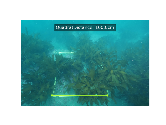
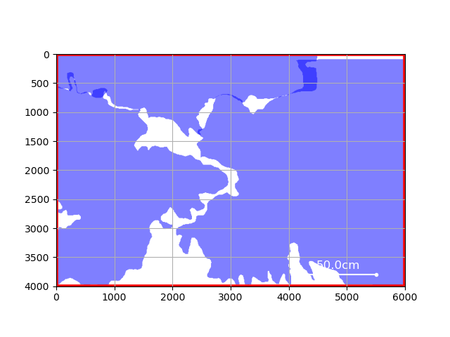
Original Yolo format Semantic Segmentation
Installation
First, install the necessary dependencies. After cloning or downloading this project, run the following command to install the package:
pip3 install .
pip install meaPolygon
This will install the module containing the meaPolygon function, making it available for use in your Python environment.
Usage
- Prepare the YOLO Format Text File Prepare a text file formatted for YOLO semantic segmentation. Each line should contain a label and normalized polygon coordinates.
Example:
0 0.1 0.2 0.3 0.4 0.5 0.6
1 0.2 0.3 0.4 0.5 0.6 0.7
- Create a Python Script
from meaPolygon import meaPolygon

# Specify the paths to the image file and the text file
img_path = "examples/data/example.png"
txt_path = "examples/data/example.txt"

# Calculate the polygon areas
areas = meaPolygon(img_path, txt_path)

# Display the results
print("Calculated Polygon Areas:", areas)
- Run the Script
python3 your_script.py
- Expected Output When you run the script, you should see output similar to the following, depending on the content of your text file and image dimensions:
Calculated Polygon Areas: [15.34, 28.92, 35.76]
Each value in the list corresponds to the area of a polygon defined in the text file. The values are in square units based on the dimensions of the input image.
Contact & Support
f you have any questions, issues, or suggestions, please feel free to contact us:
- BlueArch : https://bluearch.or.jp/
- Main Project : https://github.com/BlueArch-Project
- Email: aki2262hiro103kawano@gmail.com
- GitHub Issues: https://github.com/BlueArch-Project/PolygonAreaSegmentation/issues
For more detailed discussions, bug reports, or feature requests, please open an issue on the GitHub repository. We appreciate your feedback and contributions!


Download files
Download the file for your platform. If you're not sure which to choose, learn more about installing packages.
Source Distribution
File details
Details for the file meapolygon-0.0.6.tar.gz.
File metadata
- Download URL: meapolygon-0.0.6.tar.gz
- Upload date:
- Size: 4.9 kB
- Tags: Source
- Uploaded using Trusted Publishing? No
- Uploaded via: twine/5.1.1 CPython/3.11.9
File hashes
| Algorithm | Hash digest | |
|---|---|---|
| SHA256 |
ce85656f0ea1bfe3bf20a7b4a3f2e407b5cfc5f7d879a9fa0ef33e1cc74613d8
|
|
| MD5 |
d4fbb1a5a2622fafcc25234959a2eae4
|
|
| BLAKE2b-256 |
5a69f3e3afffc2a6fb4ca53849fdf399a106dd2d630b48fde048bf2099bf3bda
|






