
mwa_skymap
All-sky maps and movies showing the MWA telescope primary beam, based on the 'plot_MWAconstellations.py' script by David Kaplan.
This package uses the mwa_hyperbeam package (or, optionally, the old mwa_pb package) to generate all-sky maps of one or more MWA observations, showing the primary beam on the sky, with the HASLAM radio image as a background.
It consists of a library (mwaplot.py) implementing the core functionality, and a command-line wrapper script (skymap, implemented in skymap.py) to generate all-sky maps and movies. You can use the 'mwaplot.py' library from your own code if you want to customise the plots (provide your own source lists, for example).
It also includes a script (local_obs.py) to generate JSON files describing dummy observations, which can be used to generate skymaps to plan future observations.
Features include:
- Generate still frames showing the primary beam and phase centre at a single instant.
- Generate movies showing the primary beam and phase centre moving across the sky, repointing as the observations progress between the given start and stop times.
- Single frame output formats include GIF, JPEG, PNG, etc, and movie formats can be as an animated PNG (with variable length frames for more precise repointing times), or an MPEG (.mpg) file in H.264. Output formats are determined by the file extension.
- If an MWA observation includes real-time beamformer voltage beams, they will be plotted as well as the phase centre.
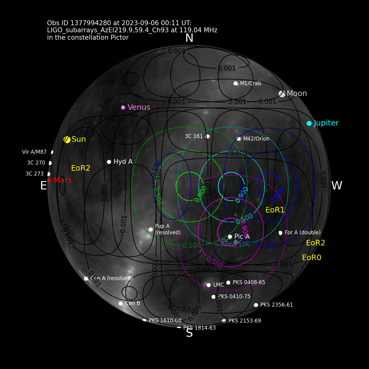
- If an observation includes primary beam subarrays (multiple sets of tiles, each with a different pointing centre), they will be plotted with a different contour colour for each subarray.
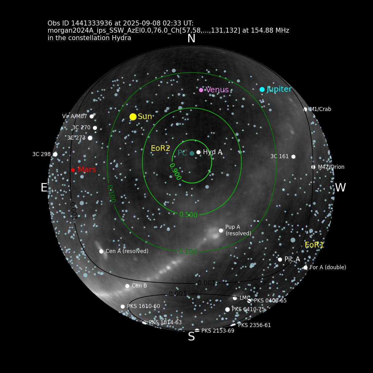
- You can optionally add the GLEAM catalogue of radio sources to the map.
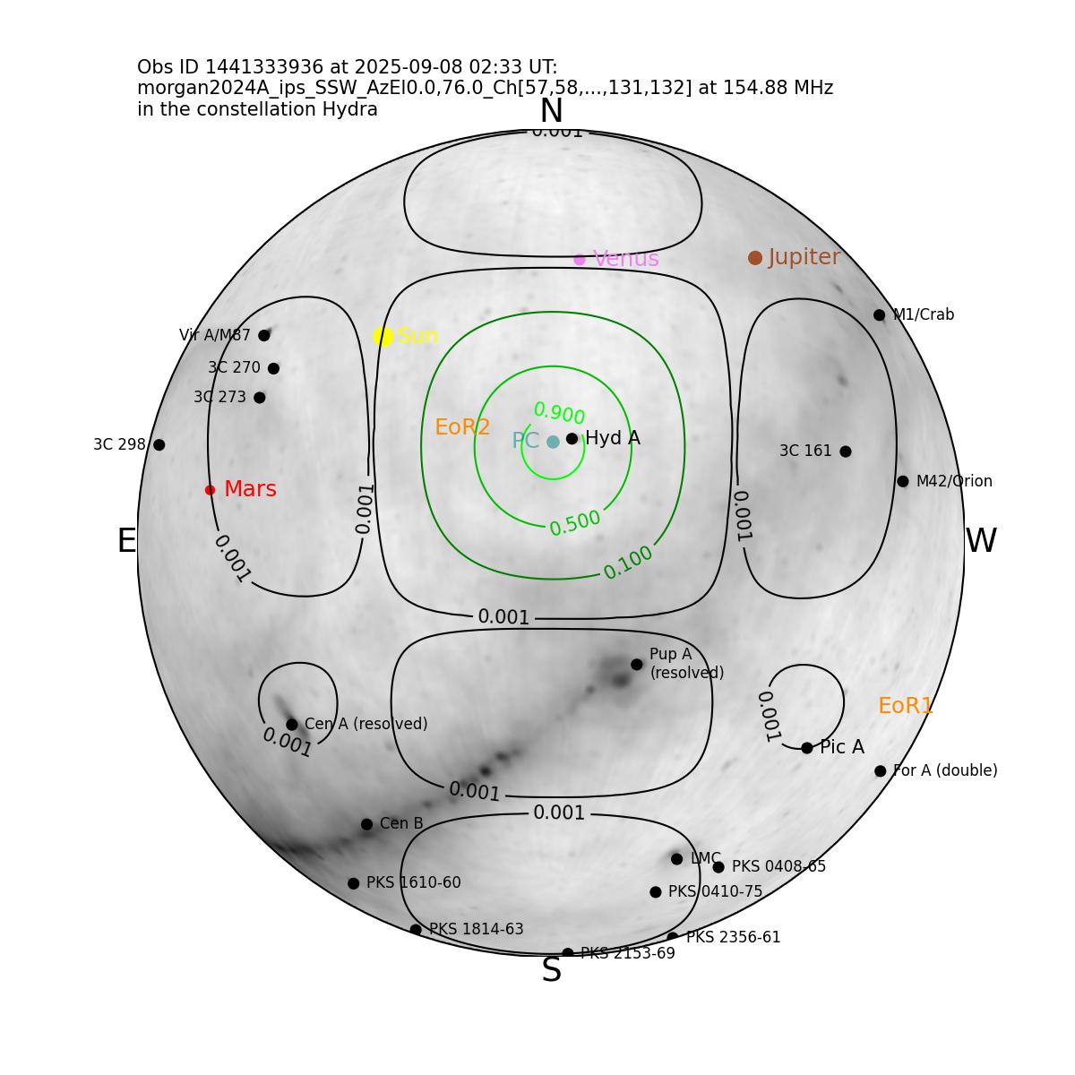
- You can plot the HASLAM background as white-on-black (the default), or in inverse mode, as black-on-white. Source markers and labels are automatically colour corrected to stand out in either mode.
- You can specify the primary beam calculation to use - one of 'HBA' (mwa_hyperbeam analytic), 'HBFEE' (mwa_hyperbeam FEE - slow without a GPU), or 'MWA_PB' (mwa_pb analytic).
- You can specify a specific coarse channel to use for the beam model (defaults to the 13th channel in the observation).
- Choice of white, black or transparent background.
- Customise (or remove) the text shown in the plot by providing a template with optional fields: '%(obsid)d', '%(viewgps_gps)d', '%(viewgps_utc)s', '%(obsname)s', '%(freq_mhz)s MHz', and '%(constellation)s'. These fields will be filled in with the observation ID, GPS time in GPS seconds, GPS time in UTC, observation name, frequency, and constellation, respectively. When generating movies, the template fields will be filled in for each frame, changing for each new observation displayed.
Getting started:
- Create and activate a Python environment.
- Install the package:
git clone https://github.com/MWATelescope/mwa_skymap.git
cd mwa_skymap
pip install .
(Optional) Download the MWA primary beam data (to use the HBFEE model)
- Download the MWA primary beam data:
skymap getbeamfile
Command line usage
The skymap command has three subcommands:
skymap single- Generate a single frame of the primary beamskymap movie- Generate a movie of the primary beamskymap getbeamfile- Download the MWA primary beam dataskymap beamtypes- print the list of primary beam models available
You can get help on the command line options with:
skymap --help
and, for example:
skymap single --help
Usage examples:
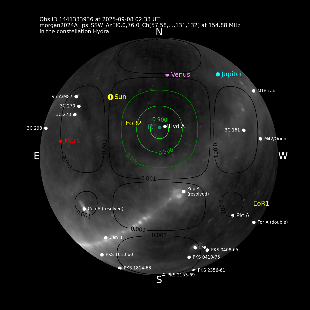
skymap single 1441333936
The same observation as black-on-white JPEG, using the hyperbeam FEE beam model:
skymap single --inverse 1441333936 --beam_type=HBFEE --background=white --outfile=1441333936-inverse.jpg
Use channel 57, and show GLEAM sources:
skymap single --gleamsources --cchan=57 1441333936 --outfile=1441333936-57-gleam.png
Showing an observation with four subarray primary beams in different colours:
skymap single 1377994280
A 4.4-hour block of EoR observations and calibrators, at 10 frames per second (each fram howing one minute of actual observing time):
skymap movie --outfile=20250908.mpg --startgps=1441386096 --stopgps=1441401784 --inverse
Local observation files
By default, skymap will use the MWA web services to look for observations in the
MWA observation database. You can also use local observation files by setting the
--ldir option to a directory containing dummy observation files in JSON format.
These files have the form <obsid>.json and are created by calling the local_obs
command, a (very simplified) version of the same command used to add real
MWA observations to the schedule database.
Note that like real MWA observations, the phase centre will be the actual RA/Dec provided, but the primary beam will be centered on the nearest sweet-spot grid position, and dipole delays calcualted accordingly.
usage
local_obs generates JSON files with simulated MWA telescope observations. Parameters include:
- --ldir: Directory to write the JSON file describing the observation.
- Either --starttime= or both --utdate= and --lst= to sepcify the observation start
- --stoptime= to specify the observation end
- One of --source=, or --ra= and --dec=, or --alt= and --az=
- --freq= with a channel specifier (defaults to 121,24)
- --obsname: Observation name.
To define the start of the observation, you can use --startime= with an argument that's one of:
- An integer in GPS seconds
- A date/time in the form 'yyyy-mm-dd,hh:mm:ss'
- A modifier, e.g. ++10s, ++1m, ++1h, relative to the current time.
Or, you can use --utdate=yyyy-mm-dd to specify the UTC date, and --lst= to specify the Local Sidereal Time, in hours, on that date.
To define the end of an observation, you use --stoptime= with an argument that's one of:
- An integer in GPS seconds
- A date/time in the form 'yyyy-mm-dd,hh:mm:ss'
- A modifier, e.g. ++10s, ++1m, ++1h, relative to the observation start time.
To define the pointing, you can:
- Specify a source name with --source= to be resolved using astropy.coordinates.SkyCoord.from_name
- Specify --ra= and --dec= using either floats (in degrees), or sexagesimal values (DD:MM:SS). Sexagesimal values for RA will be interpreted as hours, not degrees.
- Specify --alt= and --az= using floats (in degrees), or sexagesimal values (DD:MM:SS) in degrees.
The output will be a JSON file of the form .json in the current directory, or in the directory specified by the --ldir= option.
To add a (simulated) subarray pointing, call %prog once with the arguments for the observation, then call it again with exactly the same arguments except for a new pointing (ra/dec, alt/az or sourcename), and --rfstream=1 to add a subarray with the new pointing. You can repeat with --rfstream=2, etc.
To add a (simulated) real-time voltage beam, call %prog once with the arguments for the observation, then call it again with exactly the same arguments except for a new pointing (ra/dec, alt/az or sourcename), and --voltbeam=1 to add voltage beam with the new pointing. You can repeat with --voltbeam=2, etc.
Example: Schedule a 32-second observation of HerA starting in 8 seconds time:
local_obs --starttime=++8 --stoptime=++32 --source=HerA --freq=121,24
A 296s observation of CenA at a specific time, written to dummy directory:
local_obs --ldir=dummy --source=CenA --stoptime=++296 --starttime="2026-07-14,10:00:00 --obsname=cenatest --freq=145,24
A 120s observation of PicA on August 18th 2026, at an LST of 5.5 hours:
local_obs --ldir=dummy --source=PicA --stoptime=++120 --utdate=2026-08-18 --lst=5.5 --obsname=picatest --freq=145,24
A 296s observation of HydA starting 32 seconds from now:
local_obs --ra='09:18:06' --dec='-12:05:44' --stoptime=++296 --starttime=++32 --obsname=radectest --freq=145,24
Once you've generated local JSON files, you can use them with skymap:
Example: generate a skymap for the observation defined in dummy/1441333936.json
skymap single --ldir=dummy 1441333936
If the directory specified by --ldir contains more than one observation, you can pass a list of obsids or use --startgps and --stopgps to define the observation time range for a 'skymap movie ...' command.
1 maintainer

Release files for mwa-skymap 0.1.5
For a detailed explanation of source distributions (sdists) and built distributions (wheels), please see the package formats documentation.
Source distribution (sdist)
| File | Size | Uploaded | |
|---|---|---|---|
| mwa_skymap-0.1.5.tar.gz | 2.7 MB | Details |
Built distribution (wheel)
| File | Interpreter | ABI | Platform | Reset |
|---|---|---|---|---|
| mwa_skymap-0.1.5-py3-none-any.whl | Python 3 | none | any | Details |
Total release size: 5.5 MB
Release files / mwa_skymap-0.1.5.tar.gz
| Download URL | mwa_skymap-0.1.5.tar.gz |
|---|---|
| Size | 2.7 MB |
| Tags | Source |
|
SHA-256 checksum How to use checksums |
ce85677e5ac46ce68e0ca6a08ef0e2d946eff901fb1cc122d52c56f797ba93fa
|
|
BLAKE2b-256 checksum How to use checksums |
cfe312083365e1ecf635ffb23ecaaa5d14b97a96a21ca73ea853e0dd1e2469fe
|
| Upload date | |
|
Uploaded using Trusted Publishing? What is trusted publishing? |
No |
| Uploaded via |
twine/7.0.0 CPython/3.11.7
|
Release files / mwa_skymap-0.1.5-py3-none-any.whl
| Download URL | mwa_skymap-0.1.5-py3-none-any.whl |
|---|---|
| Size | 2.7 MB |
| Tags | Python 3 |
|
SHA-256 checksum How to use checksums |
26c0d10c2c4b68756cbd3b2e8e5dd90bd68e213b3aa301dcb456b5a417f17da4
|
|
BLAKE2b-256 checksum How to use checksums |
b9544f58f5df0664e89b3b7af490a59ee5def1ede1a9763fdbaca2c95bd0cdff
|
| Upload date | |
|
Uploaded using Trusted Publishing? What is trusted publishing? |
No |
| Uploaded via |
twine/7.0.0 CPython/3.11.7
|














