Python library to support analysis of topographic cross-sections

Project description
Orangery is a Python library to support analysis of topographic cross-sections, particularly on stream channels. The intent is to enable the user to write simple scripts that operate on CSV data exported from a survey data collector.


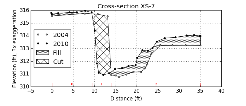
Orangery was initially a single script that allowed me to segregate, by grain size, changed areas on repeat topographic cross-sections. It can produce output plots like the one below.
Installation


To install from the Python Package Index:
$pip install orangery
To install from the source distribution execute the setup script in the orangery directory:
$python setup.py install
To install from Anaconda Cloud:
If you are starting from scratch the first thing to do is install the Anaconda Python distribution, add the necessary channels to obtain the dependencies and install orangery.
$conda config --append channels conda-forge
$conda config --append channels mrahnis
$conda install orangery
To install from the source distribution:
Execute the setup script in the orangery directory:
$python setup.py installExamples
The example scripts may be run like so:
$python plots.py
License
BSD
Documentation
Latest html


Download files
Download the file for your platform. If you're not sure which to choose, learn more about installing packages.
Source Distribution
File details
Details for the file orangery-0.4.3.tar.gz.
File metadata
- Download URL: orangery-0.4.3.tar.gz
- Upload date:
- Size: 52.7 kB
- Tags: Source
- Uploaded using Trusted Publishing? No
- Uploaded via: twine/1.13.0 pkginfo/1.5.0.1 requests/2.21.0 setuptools/40.8.0 requests-toolbelt/0.9.1 tqdm/4.31.1 CPython/3.6.3
File hashes
| Algorithm | Hash digest | |
|---|---|---|
| SHA256 |
eab74c70432f50a11424cd1efb4a612ea9c1c02e2250435685818996745ef451
|
|
| MD5 |
d932eff2498bd9b53569a2296ce9f38b
|
|
| BLAKE2b-256 |
92c375f9a093e00897542ca73046b5652466451c84e93fb38af9918568885fe2
|


