
osmimage
Render an OpenStreetMap tile image from a latitude, longitude and zoom level, and get a Pillow image back. Draw your own routes, markers or labels on top of it.
Install
pip install osmimage
Quick start
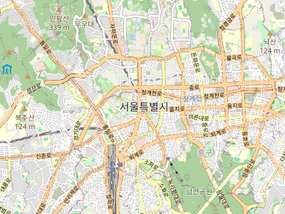
from osmimage import OSMImage

m = OSMImage(width=400, height=300)

# lat/lon/zoom -> PIL.Image (RGBA)
img = m.render(lat=37.5665, lon=126.9780, zoom=13)
img.save("seoul.png")
Fitting many points
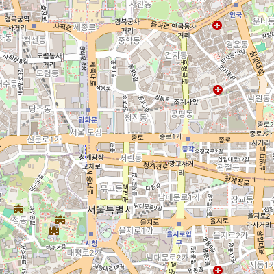
Give fit_zoom a list of (lat, lon) points and it returns the tightest zoom
at which they all fit the canvas. Pair it with center_of to get the center to
render around.
from osmimage import OSMImage

points = [(37.5665, 126.9780), (37.5700, 126.9820), (37.5740, 126.9790)]

m = OSMImage(400, 400)
zoom = m.fit_zoom(points)          # -> int, e.g. 15
lat, lon = m.center_of(points)     # -> (lat, lon) mid-point of the bounds
img = m.render(lat, lon, zoom)
img.save("area.png")
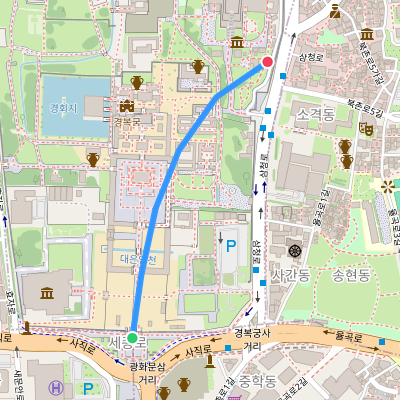
Drawing a route and markers
draw_polyline and draw_marker draw straight onto the rendered map from
geographic coordinates, anti-aliased. For anything custom, to_pixel() still
converts a coordinate to a pixel position so you can use PIL.ImageDraw.
from osmimage import OSMImage

points = [
    (37.5758, 126.9768), (37.5769, 126.9770), (37.5780, 126.9773),
    (37.5790, 126.9778), (37.5799, 126.9786), (37.5805, 126.9797),
]

m = OSMImage(400, 400)
m.render(*m.center_of(points), m.fit_zoom(points))

m.draw_polyline(points, color="#3396FF", width=6)
m.draw_marker(*points[0],  radius=7, color="#2ECC71", outline="white", outline_width=2)
m.draw_marker(*points[-1], radius=7, color="#F23F5C", outline="white", outline_width=2)

m.image.save("route.png")
(That's the image at the top of this page.)
Caching and reliability
Pass cache_dir to reuse tiles across runs (recommended, and kinder to the
tile server). Tile downloads are retried with backoff and fetched in parallel.
m = OSMImage(400, 400, cache_dir=".tile_cache", max_workers=8)
For full control, build a TileSource yourself:
from osmimage import OSMImage, TileSource

src = TileSource(
    "https://tile.openstreetmap.org/{z}/{x}/{y}.png",
    cache_dir=".tile_cache",
    max_retries=3,
    backoff=0.5,
)
m = OSMImage(400, 400, tile_source=src)
API
OSMImage(width=300, height=300, *, tile_source=None, cache_dir=None, max_workers=8)
render(lat, lon, zoom) -> PIL.Image.Image— composite covering tiles onto awidth x heightcanvas centered on the coordinate (tiles fetched in parallel). Returns an RGBA image.draw_polyline(points, *, color="#3388FF", width=4, supersample=4) -> Image— anti-aliased line through(lat, lon)points on the last render.draw_marker(lat, lon, *, radius=6, color="#F23F5C", outline=None, outline_width=0, supersample=4) -> Image— anti-aliased filled circle at a coordinate.fit_zoom(points, *, padding=5, min_zoom=0, max_zoom=19) -> int— the tightest zoom (0-19) at which all(lat, lon)points fit the canvas.center_of(points) -> (lat, lon)— mid-point of the bounds ofpoints.to_pixel(lat, lon) -> (x, y)— pixel position of a coordinate on the last rendered image. Callrender()first.image— the most recently rendered image (orNone).
TileSource(url_template=..., *, tile_size=256, user_agent=..., timeout=10.0, session=None, cache_dir=None, max_retries=2, backoff=0.5)
Fetches tiles with an in-memory + optional on-disk cache, retry/backoff, and a
parallel get_tiles(coords, max_workers=8) batch fetch. clear_cache() drops
the in-memory cache (the on-disk cache is left intact).
Tile usage policy
The default tile server is the public OpenStreetMap one. Its use is subject to
the OSM tile usage policy:
send a descriptive User-Agent, avoid bulk downloading (use cache_dir), and
for anything beyond light use, point at your own tile server.
Map data © OpenStreetMap contributors.
License
MIT
1 maintainer

Release files for osmimage 0.1.0
For a detailed explanation of source distributions (sdists) and built distributions (wheels), please see the package formats documentation.
Source distribution (sdist)
| File | Size | Uploaded | |
|---|---|---|---|
| osmimage-0.1.0.tar.gz | 13.9 kB | Details |
Built distribution (wheel)
| File | Interpreter | ABI | Platform | Reset |
|---|---|---|---|---|
| osmimage-0.1.0-py3-none-any.whl | Python 3 | none | any | Details |
Total release size: 26.9 kB
Release files / osmimage-0.1.0.tar.gz
| Download URL | osmimage-0.1.0.tar.gz |
|---|---|
| Size | 13.9 kB |
| Tags | Source |
|
SHA-256 checksum How to use checksums |
5f3606c81e27b9242d18813cb6831a0c10fa628aac276c21a376b7e67b8b1312
|
|
BLAKE2b-256 checksum How to use checksums |
7927004f6cb4bfae57bb65f0545eb918252c7ed93069d23d367a32db726bfe10
|
| Upload date | |
|
Uploaded using Trusted Publishing? What is trusted publishing? |
No |
| Uploaded via |
twine/7.0.0 CPython/3.12.13
|
Release files / osmimage-0.1.0-py3-none-any.whl
| Download URL | osmimage-0.1.0-py3-none-any.whl |
|---|---|
| Size | 12.9 kB |
| Tags | Python 3 |
|
SHA-256 checksum How to use checksums |
2a4b8a5cac89ce2852299437b48e75cbcaff2659a250ff38592885d7a9f43910
|
|
BLAKE2b-256 checksum How to use checksums |
f33ad3167db80582bd4dd579c86997fb9e051211583950a4f78b1b5c78f18210
|
| Upload date | |
|
Uploaded using Trusted Publishing? What is trusted publishing? |
No |
| Uploaded via |
twine/7.0.0 CPython/3.12.13
|













