Lib to convert Overture data in GIS formats and upload it to HDX

Project description
Overture Map Data 2 HDX
This project is designed to export geographic data from Overture Maps and upload it to the Humanitarian Data Exchange (HDX). The data is processed using DuckDB and can be exported in various formats such as GeoJSON, GPKG, and ESRI Shapefile.
Features
- Export geographic data from Overture Maps.
- Upload data to HDX.
- Support for multiple output formats.
- Configurable via YAML and environment variables.
- Logging setup using environment variables or parameters.
Installation
pip install overture2hdx
Configuration
The application is configured using a YAML file and environment variables.
YAML Configuration
Example config.yaml:
iso3: npl
geom: '{"type": "FeatureCollection", "features": [{"type": "Feature", "properties": {}, "geometry": {"coordinates": [[]], "type": "Polygon"}}]}'
key: osgeonepal_pkr
subnational: true
frequency: yearly
categories:
- Roads:
    select:
        - id
        - names.primary as name
        - class as class
        - subclass as subclass
        - UNNEST(JSON_EXTRACT(road_surface, '$[*].value')) as road_surface
        - UNNEST(JSON_EXTRACT(sources, '$[*].dataset')) AS source
    hdx:
        title: Roads of Pokhara
        notes: Overturemaps Export for Pokhara. Data might have errors but has gone through validation checks.
        tags:
        - geodata
        - transportation
        - roads
    theme:
        - transportation
    feature_type:
        - segment
    formats:
        - gpkg
        - shp
Code Overview
Config: Class to handle configuration.
OvertureMapExporter: Class to handle the export process.
setup_logging: Function to set up logging.
Default export config
Following is the default yaml used
| Category | Description | License | Overture Theme Docs | Attributes | File Formats |
|---|---|---|---|---|---|
| Hospitals | Health POIs such as hospitals and clinics, sourced from Meta and Microsoft open data | CDLA Permissive 2.0 | Places | id, name, name_en, category, address, phone, email, website, confidence, source |
gpkg, shp |
| Schools | Educational POIs including schools, colleges, and universities from Meta and Microsoft | CDLA Permissive 2.0 | Places | id, name, name_en, category, address, phone, website, confidence, source |
gpkg, shp |
| Rivers | Rivers, lakes, and other water features from OpenStreetMap via the Base theme | ODbL 1.0 | Base | id, name, name_en, subtype, class, is_salt, wikidata, source |
gpkg, shp |
| Land Use | Land use areas like farmland and forests from OpenStreetMap landuse tags | ODbL 1.0 | Base | id, name, name_en, subtype, class, surface, wikidata, source |
gpkg, shp |
| Transportation Hubs | POIs like airports, train stations, and terminals from Meta and Microsoft open data | CDLA Permissive 2.0 | Places | id, name, name_en, category, address, phone, website, confidence, source |
gpkg, shp |
| Settlements | Cities, towns, villages, and hamlets from OSM, geoBoundaries, and Esri | ODbL 1.0 | Divisions | id, name, name_en, population, region, wikidata, source |
gpkg, shp |
| Roads | Roads including highways and local roads from OpenStreetMap and TomTom | ODbL 1.0 | Transportation | id, name, name_en, class, subclass, subtype, road_surface, source |
gpkg, shp |
| Buildings | Building footprints from OSM, Microsoft, Google, and Esri | ODbL 1.0 | Buildings | id, name, name_en, class, subtype, height, level, num_floors, num_floors_underground, is_underground, has_parts, roof_material, roof_shape, roof_color, source |
gpkg, shp |
Default python example
import json

geom = json.dumps(
    {
        "type": "FeatureCollection",
        "features": [
            {
                "type": "Feature",
                "properties": {},
                "geometry": {
                    "coordinates": [
                        [
                            [83.98047393581618, 28.255338988044088],
                            [83.973540694181, 28.230486421513703],
                            [83.91927014759125, 28.214265947308945],
                            [83.97832224013575, 28.195093119231174],
                            [83.96971545741735, 28.158212628626416],
                            [84.00175181531534, 28.19361814379657],
                            [84.03187555483152, 28.168540447741847],
                            [84.01059767533235, 28.208788347541898],
                            [84.0342663278089, 28.255549578267903],
                            [83.99960011963498, 28.228801292171724],
                            [83.98047393581618, 28.255338988044088],
                        ]
                    ],
                    "type": "Polygon",
                },
            }
        ],
    }
)
iso3 = "NPL"
dataset_name = "Pokhara, Nepal"
key = "osegonepal_pkr"
subnational = True
frequency = "yearly"

from overture2hdx import DEFAULT_CONFIG_YAML

config_yaml = DEFAULT_CONFIG_YAML.format(
    iso3=iso3,
    geom=geom,
    key=key,
    subnational=subnational,
    frequency=frequency,
    dataset_name=dataset_name,
)


from overture2hdx import Config, Exporter

config = Config(config_yaml=config_yaml)
exporter = Exporter(config)
results = exporter.export()
print(results)
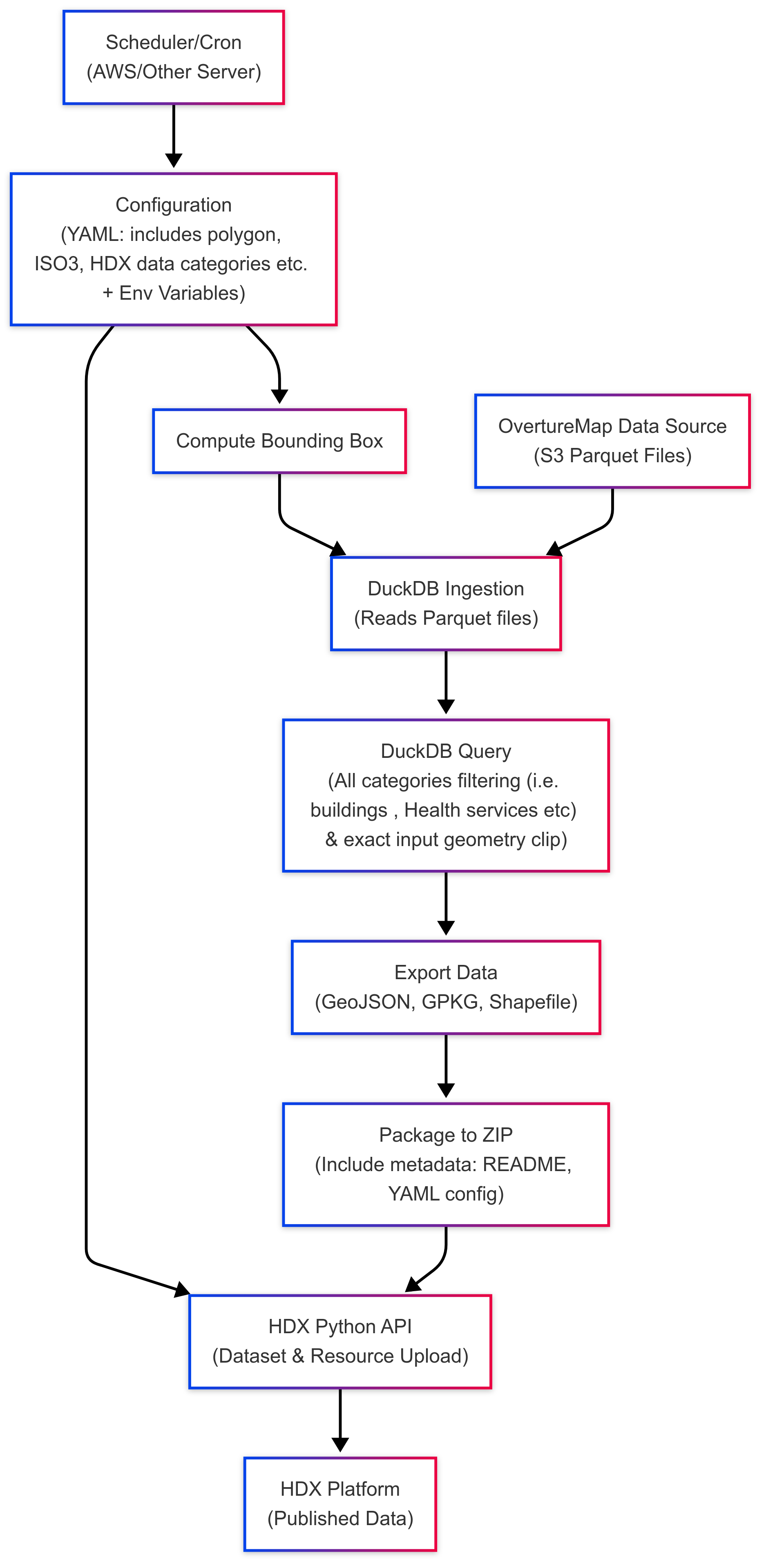
How it works?
Author and License
Kshitij Raj Sharma , License : GNU GENERAL PUBLIC LICENSE V3


Download files
Download the file for your platform. If you're not sure which to choose, learn more about installing packages.
Source Distribution
Built Distribution
Filter files by name, interpreter, ABI, and platform.
If you're not sure about the file name format, learn more about wheel file names.
Copy a direct link to the current filters
File details
Details for the file overture2hdx-0.1.1.tar.gz.
File metadata
- Download URL: overture2hdx-0.1.1.tar.gz
- Upload date:
- Size: 27.9 kB
- Tags: Source
- Uploaded using Trusted Publishing? No
- Uploaded via: twine/6.1.0 CPython/3.11.11
File hashes
| Algorithm | Hash digest | |
|---|---|---|
| SHA256 |
56a2a4750ccbf102bf6075743d523c9e1bf2501326c5beb57b039d053723128c
|
|
| MD5 |
01ea877be5eb4c015a86bf2af1e899d7
|
|
| BLAKE2b-256 |
6b68b4ea6ef88d4f40bac4009cd4ba68d89f1adbd160af889f26f96305bcf198
|
File details
Details for the file overture2hdx-0.1.1-py3-none-any.whl.
File metadata
- Download URL: overture2hdx-0.1.1-py3-none-any.whl
- Upload date:
- Size: 25.7 kB
- Tags: Python 3
- Uploaded using Trusted Publishing? No
- Uploaded via: twine/6.1.0 CPython/3.11.11
File hashes
| Algorithm | Hash digest | |
|---|---|---|
| SHA256 |
78b3db7c7d35ba8f2f8171ef217a285c841d19906a2fdb23f9159a0d08755a40
|
|
| MD5 |
7134776e1b16a6ce37dc90ec300b9c8a
|
|
| BLAKE2b-256 |
ce38352fd18e14427d9bf9606954296dafddab30fd8b15ed63cfd6374f3de865
|


