Link your photos into a KML ("Google Earth") file based on their geolocation

Project description
photokml
Generates a .kml geoindex of photographs based on GPS information in EXIF tags.
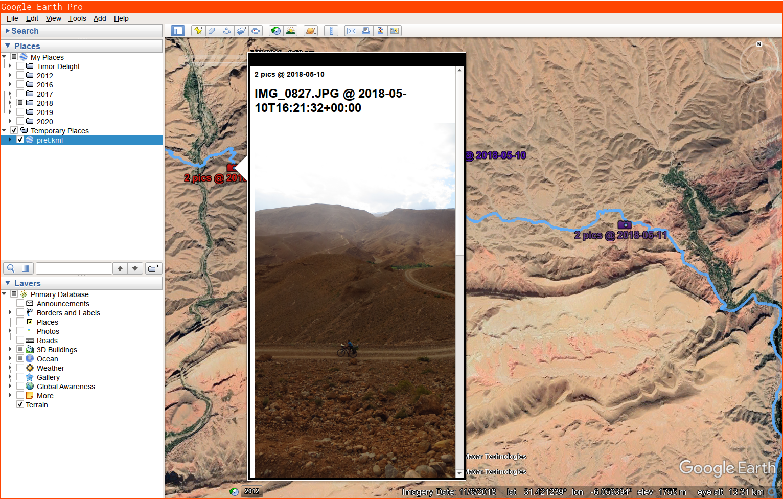
Run it on a bunch of photos, load up the .kml in Google Earth, and click the icons to view your pictures. Screenshot:
usage: photokml.py [-h] [-x MAXWIDTH] [-y MAXHEIGHT] [-b BUNCHUP]
                   FILE [FILE ...]

Generates a .kml geoindex (on stdout) of photographs based on GPS information
in EXIF tags.

positional arguments:
  FILE

optional arguments:
  -h, --help            show this help message and exit
  -x MAXWIDTH, --maxwidth MAXWIDTH
                        Limit picture display width to N pixels (1200 by
                        default)
  -y MAXHEIGHT, --maxheight MAXHEIGHT
                        Limit picture display height to N pixels (700 by
                        default)
  -b BUNCHUP, --bunchup BUNCHUP
                        Form clusters of pictures within N meters of eachother
                        (10 by default)
Release history Release notifications | RSS feed


Download files
Download the file for your platform. If you're not sure which to choose, learn more about installing packages.
Source Distribution
photokml-0.1.1.tar.gz
(16.2 kB
view details)
Built Distribution
Filter files by name, interpreter, ABI, and platform.
If you're not sure about the file name format, learn more about wheel file names.
Copy a direct link to the current filters
photokml-0.1.1-py3-none-any.whl
(16.4 kB
view details)
File details
Details for the file photokml-0.1.1.tar.gz.
File metadata
- Download URL: photokml-0.1.1.tar.gz
- Upload date:
- Size: 16.2 kB
- Tags: Source
- Uploaded using Trusted Publishing? No
- Uploaded via: twine/3.7.0 importlib_metadata/4.8.2 pkginfo/1.8.2 requests/2.26.0 requests-toolbelt/0.9.1 tqdm/4.62.3 CPython/3.9.9
File hashes
| Algorithm | Hash digest | |
|---|---|---|
| SHA256 |
d2289cb7e501214ca95f2cf366794cf13dc6d06dcb6c0b8563469f6d4dd72e8e
|
|
| MD5 |
917633a7bc67c145d14c9c3bc50ce2a6
|
|
| BLAKE2b-256 |
81b1a33169bf1df5d4e3eda655347d94e704e02c7238fd5a97ddff66d42a3ef2
|
File details
Details for the file photokml-0.1.1-py3-none-any.whl.
File metadata
- Download URL: photokml-0.1.1-py3-none-any.whl
- Upload date:
- Size: 16.4 kB
- Tags: Python 3
- Uploaded using Trusted Publishing? No
- Uploaded via: twine/3.7.0 importlib_metadata/4.8.2 pkginfo/1.8.2 requests/2.26.0 requests-toolbelt/0.9.1 tqdm/4.62.3 CPython/3.9.9
File hashes
| Algorithm | Hash digest | |
|---|---|---|
| SHA256 |
56c6a46fe86776fb97d5d4ad3975ea298bdea285ab7dc72bcd67548d75f9fe83
|
|
| MD5 |
ffd4a9cc974dccbac1c511d4fafd9d51
|
|
| BLAKE2b-256 |
927dbf84df4cdff83ad13f4ef719325cd46376f51c7a98677ac7aebf747da1eb
|


