Open-source interface for processing recreation-grade side scan sonar datasets and reproducibly mapping benthic habitat

Project description
PING-Mapper


Transform recordings from recreation-grade side scan sonar systems...
Video made with HumViewer
...into scientific datasets!
Overview
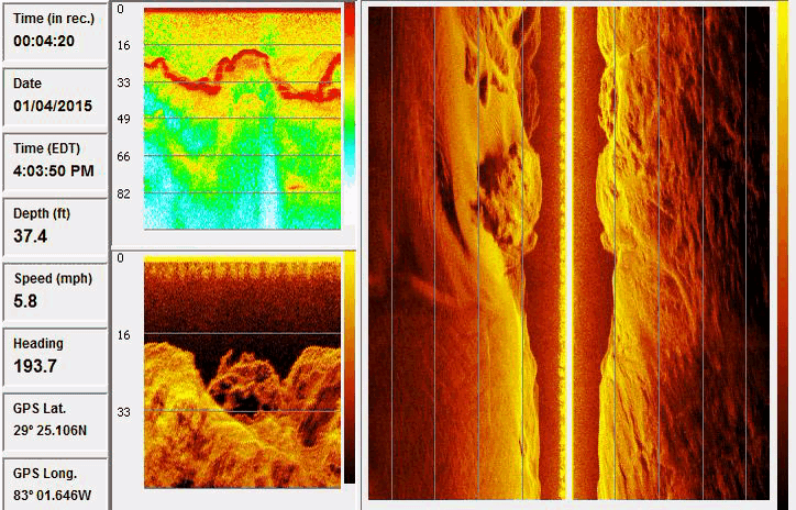
PINGMapper is an open-source Python interface for reading and processing side scan sonar datasets and reproducibly mapping benthic habitat features. PINGMapper transforms recreation-grade sonar systems (i.e. fishfinders) into scientific data collectors, allowing researchers and citizens alike to reproducibly map their aquatic system with minimal expertise in data processing.
Learn More Now!
Check out PING-Mapper's website for most up to date information:
- Homepage
- Getting Started
- Advanced Topics
- Tutorials
- FAQ's
- and more!
Published Documentation
v1.0.0 (August 29, 2022)
An overview of PINGMapper v1.0.0 functionality and justification are published in AGU's Earth and Space Science scientific journal.
Journal Article
Bodine, C. S., Buscombe, D., Best, R. J., Redner, J. A., & Kaeser, A. J. (2022). PING-Mapper: Open-source software for automated benthic imaging and mapping using recreation-grade sonar. Earth and Space Science, 9, e2022EA002469. https://doi.org/10.1029/2022EA002469
Preprint

Code

v2.0.0 (July 9, 2024)
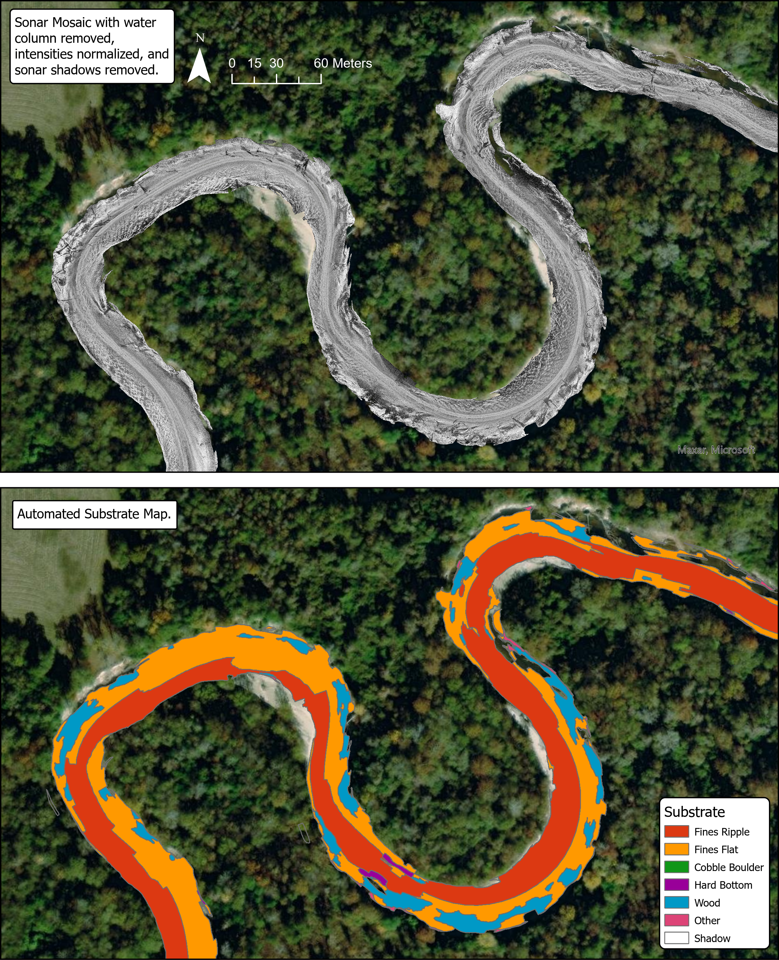
A manuscript detailing the automated substrate mapping features made availabe in v2.0.0 is published in AGU's Journal of Geophysical Research: Machine Learning and Computation.
Journal Article
Bodine, C. S., Buscombe, D., & Hocking, T. D. (2024). Automated river substrate mapping from sonar imagery with machine learning. Journal of Geophysical Research: Machine Learning and Computation, 1, e2024JH000135. https://doi.org/10.1029/2024JH000135
Preprint

Code

Segmentation models

Segmentation model training datasets

Acknowledgements
v1.0 - 2.0
This study was originally made possible by a partnership between the U.S. Fish and Wildlife Service and Northern Arizona University. Funding for this work was provided by the Open Ocean Trustee Implementation Group to restore natural resources injured by the 2010 Deepwater Horizon oil spill in the Gulf of Mexico. The contents of this website are those of the authors and do not necessarily represent the views of the U.S. Fish and Wildlife Service or Northern Arizona University.
Primary Developer: Dr. Cameron S. Bodine
Co-Developer: Dr. Daniel Buscombe
Project Collaborators: Thanks to Adam Kaeser (USFWS), Channing St. Aubin (USFWS), Mike Andres (USM), Kasea Price (USM), Alyssa Pagel (USM), Eric Haffey (USM), and Katherine Wright (USM).
Advocates & Early-Adopters: A special thanks to advocates and early-adoptors including, but not limited to, Jennylyn Redner, Adrian Pinchbeck, Art Trembanis, Dan Carlson, Alan Ryon, Mirko Denecke, Dan Haught, Dan Hamill, Mark Lundine, Elizabeth Greenheck, Hendra Kurnia Febriawan, Bryan Bozeman, Paul Grams, Matt Kaplinski, Jess Kozarek, Chris Milliren, Brett Connell and James Parham.
PhD Committee: Cameron wishes to thank his PhD dissertation committee: Toby Hocking, Co-Chair; advisor Dan Buscombe, Co-Chair; Rebecca Best; and Adam Kaeser.
v3.0 - 4.0
Continued support for PINGMapper and tools in the PING Ecosystem is made possible through mentorship, partnerships, and financial support listed below.
Primary Developer: Dr. Cameron S. Bodine
PostDoctoral Advisor: Dr. Arthur Trembanis
Lab: Coastal Sediments, Hydrodynamics and Engineering Lab (CSHEL)
Institution: College of Earth, Ocean, & Environment (CEOE) at the University of Delaware
Advocates & Mentors: Vincent Capone - Black Laser Learning
Ready to get started?
Follow the installation and testing instructions to Get Started!
Future Development, Collaborations, & Partnerships
If you are interested in partnering on future developments, please reach out to Cameron Bodine.
PING-Mapper is part of the Doodleverse!

The Doodleverse is an opinionated collection of Python packages designed for geoscientific image segmentation. Find out more on GitHub.
Release history Release notifications | RSS feed


Download files
Download the file for your platform. If you're not sure which to choose, learn more about installing packages.
Source Distribution
Built Distribution
Filter files by name, interpreter, ABI, and platform.
If you're not sure about the file name format, learn more about wheel file names.
Copy a direct link to the current filters
File details
Details for the file pingmapper-5.0.15.tar.gz.
File metadata
- Download URL: pingmapper-5.0.15.tar.gz
- Upload date:
- Size: 134.6 kB
- Tags: Source
- Uploaded using Trusted Publishing? No
- Uploaded via: twine/6.2.0 CPython/3.12.12
File hashes
| Algorithm | Hash digest | |
|---|---|---|
| SHA256 |
da23ce8ba17a6de1086d5b96417daed6944b742657e63f539ec8b39173db85dc
|
|
| MD5 |
1d7c363c46c0f7fcc23c04b46376c9e9
|
|
| BLAKE2b-256 |
b4a1b530455687790d89bfe3d6a3dfa571285e60c70f9e1b6d906e9ce486d2a2
|
File details
Details for the file pingmapper-5.0.15-py3-none-any.whl.
File metadata
- Download URL: pingmapper-5.0.15-py3-none-any.whl
- Upload date:
- Size: 143.7 kB
- Tags: Python 3
- Uploaded using Trusted Publishing? No
- Uploaded via: twine/6.2.0 CPython/3.12.12
File hashes
| Algorithm | Hash digest | |
|---|---|---|
| SHA256 |
ea0937948ddf35fe5ae36b4f78f3d5bae65a1ffc1bfd5ccda4d0d8ac208e343b
|
|
| MD5 |
a72ea1eba4658930732fc259b29aef06
|
|
| BLAKE2b-256 |
738481be931c6bb119e5d4e243b38dbf4674054c4a63e12fc88717a9cae70545
|


