pix2vec produces a vector representation of planetary mapping spectrometers hyperspectral and camera ISIS data cube

Project description
pix2vec
Geospatial Vector Representation of Planetary Remote Sensing Hyperspectral Data


pix2vec: Vector Representation of Planetary Hyperspectral Data Cubes
Free software: GNU General Public License v3
Documentation: https://pix2vec.readthedocs.io.
Features
Produces a vector representation of the raster representation of HSI data ‘cubes’ generated by ISIS
Requirements
a relatively recent Integrated Software for Imagers and Spectrometers (ISIS) installation and the kalasiris module (which will be installed automatically).
Cite in your work
Frigeri, A. and Hare, T. 2023. Geospatial Vector Representation of Planetary Mapping Spectrometer Data. 6th Planetay Data Workshop, Flagstaff, Arizona 26-28th June 2023, Abstract #7088.:
@INPROCEEDINGS{FrigeriHare2023,
      author = {{Frigeri}, A. and {Hare}, T.},
       title = "{Geospatial Vector Representation of Planetary Mapping Spectrometer Data}",
   booktitle = {6th Planetay Data Workshop},
        year = 2023,
      series = {LPI},
       month = jun,
         eid = {7088},
       pages = {7088}
}
installation
within a working ISIS environment, run:
pip install pix2vect
pix2vec in brief
pix2vect requires spice-initialized ISIS cubes (see spiceinit).
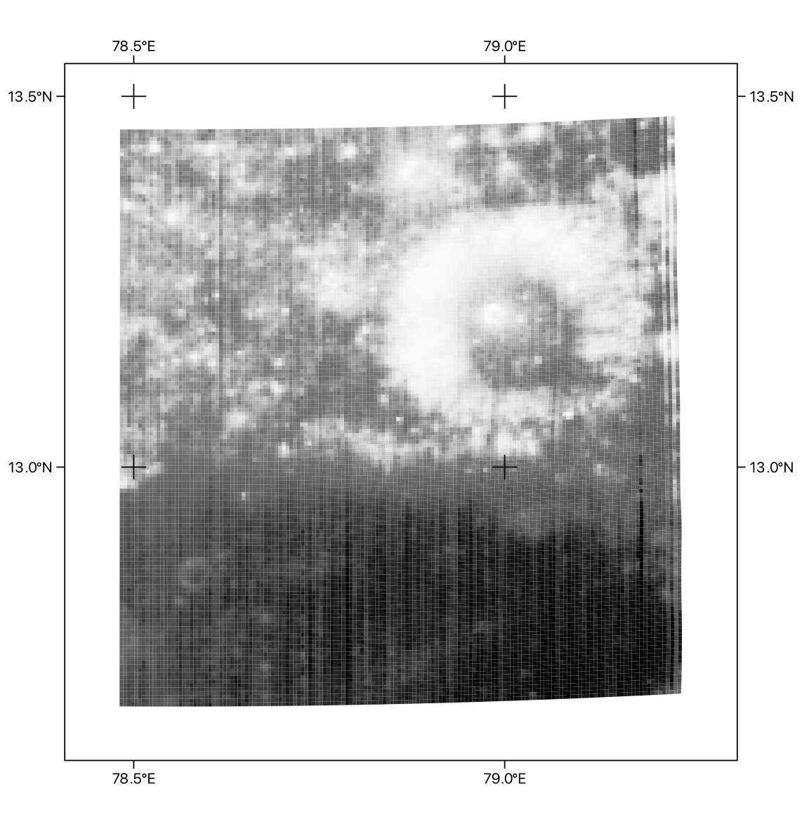
Let’s start with an hyperspectral cube from the The Moon Mineralogy Mapper (M3), the NASA spectrometer onboard Chandrayaan-1 mission to the Moon:
(ISIS) $ pix2vec -i -c M3G20090103T084105_V03_L1B.cub
pix2vect - 2023 Alessandro Frigeri - Istituto Nazionale di Astrofisica
Cube Type:M3 samples:304 lines:11739 file:M3G20090103T084105_V03_L1B.cub
now we create a vector GIS file representing the geometry of the sensor’s pixel on the lunar surface:
pix2vec -c M3G20090103T084105_V03_L1B.cub -s 1,150 -l 3050,3200 -o M3G20090103T084105_V03_L1B_subset.gpkg
the vector file can then be loaded in your favorite GIS, and we can plot the file with a PixelValue greyscale:
each ground pixel element holds information that can be accessed:
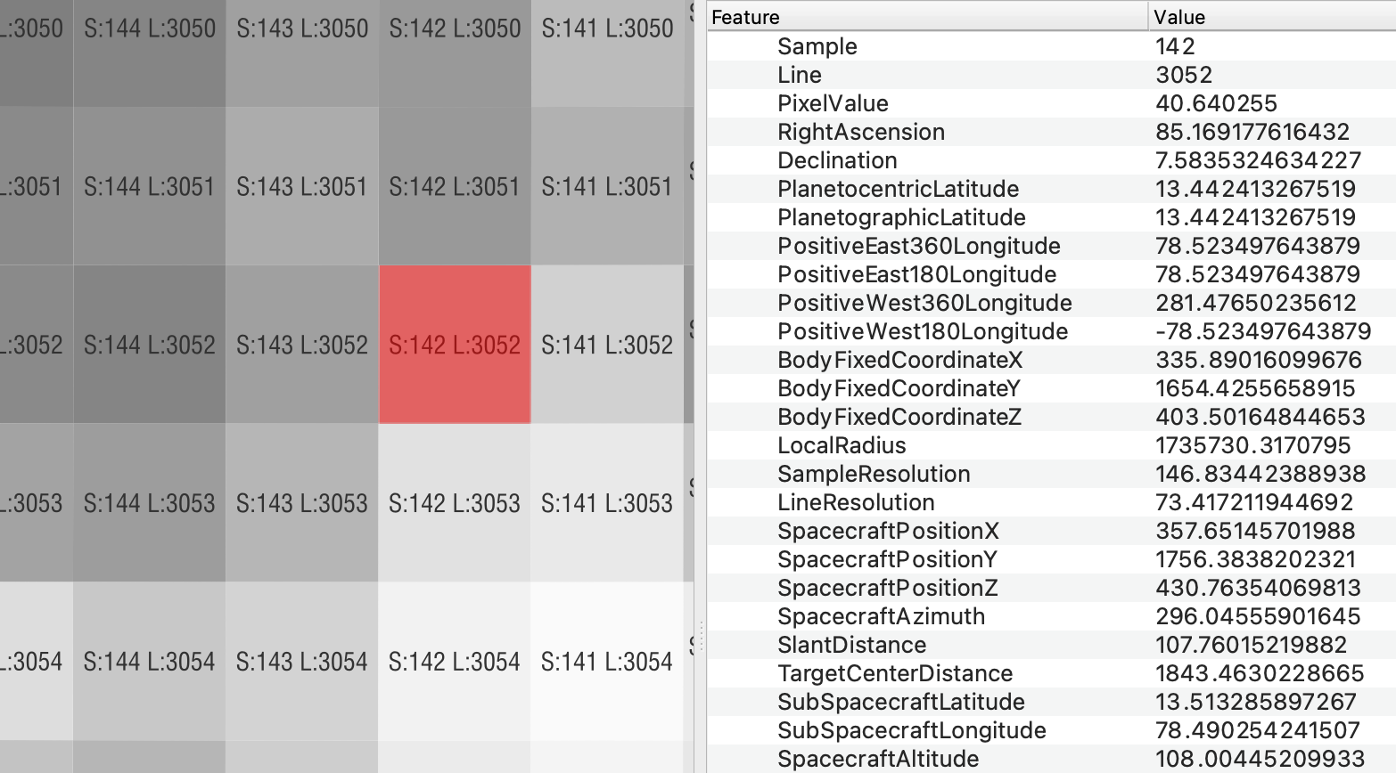
for each ground-projected pixel, you now have access to these fields:
Filename Sample Line PixelValue RightAscension Declination
PlanetocentricLatitude PlanetographicLatitude PositiveEast360Longitude
PositiveEast180Longitude PositiveWest360Longitude PositiveWest180Longitude
BodyFixedCoordinateX BodyFixedCoordinateY BodyFixedCoordinateZ LocalRadius
SampleResolution LineResolution SpacecraftPositionX SpacecraftPositionY
SpacecraftPositionZ SpacecraftAzimuth SlantDistance TargetCenterDistance
SubSpacecraftLatitude SubSpacecraftLongitude SpacecraftAltitude OffNadirAngle
SubSpacecraftGroundAzimuth SunPositionX SunPositionY SunPositionZ
SubSolarAzimuth SolarDistance SubSolarLatitude SubSolarLongitude
SubSolarGroundAzimuth Phase Incidence Emission NorthAzimuth EphemerisTime UTC
LocalSolarTime SolarLongitude LookDirectionBodyFixedX LookDirectionBodyFixedY
LookDirectionBodyFixedZ LookDirectionJ2000X LookDirectionJ2000Y
LookDirectionJ2000Z LookDirectionCameraX LookDirectionCameraY
LookDirectionCameraZ ObliqueDetectorResolution ObliquePixelResolution
ObliqueLineResolution ObliqueSampleResolution Error
Documentation
Documentation is available at https://pix2vec.readthedocs.io
History
0.1.3 (2023-07-08)
fixed image link and typos in docs.
0.1.2 (2023-06-25)
added complete support for Mars and Moon IAU spatial reference systems
version presented at the 6th Planetary Data Workshop in Flagstaff, Arizona
0.1.1 (2023-06-23)
added complete set of fields.
0.1.0 (2023-06-21)
First release on PyPI.


Download files
Download the file for your platform. If you're not sure which to choose, learn more about installing packages.
Source Distribution
Built Distribution
Filter files by name, interpreter, ABI, and platform.
If you're not sure about the file name format, learn more about wheel file names.
Copy a direct link to the current filters
File details
Details for the file pix2vec-0.1.5.tar.gz.
File metadata
- Download URL: pix2vec-0.1.5.tar.gz
- Upload date:
- Size: 3.4 MB
- Tags: Source
- Uploaded using Trusted Publishing? No
- Uploaded via: twine/4.0.2 CPython/3.9.17
File hashes
| Algorithm | Hash digest | |
|---|---|---|
| SHA256 |
eca214cb7f403d4e47a41b7a4db3f424d947177e06ac472a2a2d5fe3e0eafd9e
|
|
| MD5 |
88d4222ce0022adc7a2c1e52209d4fe4
|
|
| BLAKE2b-256 |
ca81dd20844e0621767bd3a0cd451bfef4ff65c3452d3dcf21b92143fab8795a
|
File details
Details for the file pix2vec-0.1.5-py2.py3-none-any.whl.
File metadata
- Download URL: pix2vec-0.1.5-py2.py3-none-any.whl
- Upload date:
- Size: 8.5 kB
- Tags: Python 2, Python 3
- Uploaded using Trusted Publishing? No
- Uploaded via: twine/4.0.2 CPython/3.9.17
File hashes
| Algorithm | Hash digest | |
|---|---|---|
| SHA256 |
f2d257618f01548f3af1ef77358591957eb4e550c7a02223cf9a8b5a1c204359
|
|
| MD5 |
5330c7cf5eae9d0a418c261340abdc9b
|
|
| BLAKE2b-256 |
eb0b39820c5761750e84b392b5729a74ef071d1fdb0dccdf36a753be9a769eeb
|


