Library for change detection in 4D point cloud data
Verified details
These details have been verified by PyPIProject links
GitHub Statistics
Maintainers


Project description
Welcome to py4dgeo


py4dgeo is a C++ library with Python bindings for change analysis in multitemporal and 4D point clouds.
Topographic 3D/4D point clouds are omnipresent in geosciences, environmental, ecological and archaeological sciences, robotics, and many more fields and applications. Technology to capture such data using laser scanning and photogrammetric techniques have evolved into standard tools. Dense time series of topographic point clouds are becoming increasing available and require tools for automatic analysis. Moreover, methods considering the full 4D (3D space + time) data are being developed in research and need to be made available in an accessible way with flexible integration into existent workflows.
The main objective of py4dgeo is to bundle and provide different methods of 3D/4D change analysis in a dedicated, comprehensive Python library.
py4dgeo is designed as an international open source project that can be integrated into almost any 3D and GIS software in the geodata domain supporting Python, e.g. as plugins.
py4dgeo is under ongoing active development.
Below, you find a list of provided methods.
🔨 Methods provided by py4dgeo
-
M3C2 algorithm (Lague et al., 2013) for bitemporal point cloud distance computation.
-
M3C2-EP (M3C2-EP; Winiwarter et al., 2021) for statistical signal-noise separation in change analysis through error propagation.
-
4D objects-by-change (4D-OBC; Anders et al., 2021) for time series-based extraction of surface activities.
-
Correspondence-driven plane-based M3C2 (Zahs et al., 2022) for lower uncertainty in 3D topographic change quantification [under active development].
-
Point cloud registration using standard ICP by calculating and applying affine transformations to point clouds using a standard ICP implementations.
-
Point cloud registration with automatic determination of stable areas (Yang et al., 2022) for multitemporal change detection.
-
Hierarchical 3D surface change analysis for near real-time 3D surface change analysis of permanent laser scanning point clouds (Tabernig et al., 2025)
🎮 Examples
Demo notebooks using methods provided by py4dgeo
 |
 |
 |
 |
 |
 |
 |
 |
💻 Installation
Prerequisites
Using py4dgeo requires the following software installed:
- 64-bit Python
>= 3.10(32-bit installations might cause trouble during installation of dependencies)
In order to build the package from source, the following tools are also needed.
- A C++17-compliant compiler
- Doxygen (optional, documentation building is skipped if missing)
Installing py4dgeo
The preferred way of installing py4dgeo is using pip.
Installing the release version using pip
py4dgeo can be installed using pip to obtain the current release:
python -m pip install py4dgeo
Building from source using pip
The following sequence of commands is used to build py4dgeo from source:
git clone --recursive https://github.com/3dgeo-heidelberg/py4dgeo.git
cd py4dgeo
python -m pip install -v --editable .
The --editable flag allows you to change the Python sources of py4dgeo without
reinstalling the package. The -v flag enables verbose output which gives you
detailed information about the compilation process that you should include into
potential bug reports. To recompile the C++ source, please run pip install again.
In order to enable multi-threading on builds from source, your compiler toolchain
needs to support OpenMP.
If you want to contribute to the library's development you should also install its additional Python dependencies for testing and documentation building:
python -m pip install -r requirements-dev.txt
🪟 Windows-specific Notes
py4dgeo works on Windows, but optimal performance is typically achieved on Linux.
If you want to experiment with performance on your system, you can tune OpenMP using environment variables such as OMP_NUM_THREADS, OMP_PROC_BIND, and OMP_PLACES.
The best settings depend on your system, so there is no single recommended configuration.
Setting up py4dgeo using Docker
Additionally, py4dgeo provides a Docker image that allows to explore
the library using JupyterLab. The image can be locally built and run with
the following commands:
docker build -t py4dgeo:latest .
docker run -t -p 8888:8888 py4dgeo:latest
🐍 Documentation of software usage
As a starting point, please have a look to the Jupyter Notebooks available in the repository and find the py4dgeo documentation on readthedocs.
🌐 Published test data
If you are looking for data to test different methods, consider the following open data publications:
Hourly TLS point clouds of a sandy beach

Vos et al. (2022): https://doi.org/10.1038/s41597-022-01291-9.
By-weekly TLS point clouds of an Alpine rock glacier
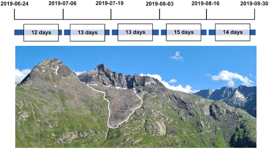
Zahs et al. (2022): https://doi.org/10.11588/data/TGSVUI.
📑 Citation
If you use py4dgeo in a scientific context, please cite the following article:
@Article{py4dgeo_softwarex,
   author = {Anders, K. and Kempf, D. and Albert, W. and Andriushchenko, P. and Huang, X. and Hulskemper, D. and Isensee, T. and Kapitan, D. and Tabernig, R. and Weiser, H. and Winiwarter, L. and Zahs, V. and Höfle, B.},
   title = {py4dgeo: Open-source scientific software for topographic change analysis in 3D/4D geographic point clouds},
   journal = {SoftwareX},
   volume = {34},
   pages = {102670},
   DOI = {10.1016/j.softx.2026.102670},
   year = {2026},
   type = {Journal Article}
}
As a software citation, please reference the appropriate release version. You can find the Bibtex reference of the latest release via the Cite this repository link on the right side of this website (source: CITATION.cff).
💟 Funding / Acknowledgements
The initial software development was supported by the Scientific Software Center (SSC) in the Open Call 2021. The scientific software project is further supported by the research projects Extract4D, CharAct4D and AImon5.0.
🔔 Contact / Bugs / Feature Requests
You think you have found a bug or have specific request for a new feature? Please open a new issue in the online code repository on Github. Also for general questions please use the issue system.
Scientific requests can be directed to the 3DGeo Research Group Heidelberg and its respective members.
📄 How to contribute
We welcome contributions of new methods and usage demonstrations! Please see the full guidelines in our CONTRIBUTING.md for details on how to get started.
📜 License
See LICENSE.md.
📚 Related literature
- Anders, K., Winiwarter, L., Mara, H., Lindenbergh, R., Vos, S.E. & Höfle, B. (2021): Fully automatic spatiotemporal segmentation of 3D LiDAR time series for the extraction of natural surface changes. ISPRS Journal of Photogrammetry and Remote Sensing, 173, pp. 297-308. DOI: 10.1016/j.isprsjprs.2021.01.015.
- Lague, D., Brodu, N., & Leroux, J. (2013). Accurate 3D comparison of complex topography with terrestrial laser scanner: Application to the Rangitikei canyon (N-Z). ISPRS Journal of Photogrammetry and Remote Sensing, 82, pp. 10-26. DOI: 10.1016/j.isprsjprs.2013.04.009.
- Tabernig, R., Albert, W., Weiser, H., & Höfle, B. (2025). A hierarchical approach for near real-time 3D surface change analysis of permanent laser scanning point clouds. In: 6th Joint International Symposium on Deformation Monitoring (JISDM). DOI: 10.5445/IR/1000180377
- Winiwarter, L., Anders, K., Höfle, B. (2021): M3C2-EP: Pushing the limits of 3D topographic point cloud change detection by error propagation. ISPRS Journal of Photogrammetry and Remote Sensing, 178, pp. 240–258. DOI: 10.1016/j.isprsjprs.2021.06.011.
- Zahs, V., Winiwarter, L., Anders, K., Williams, J.G., Rutzinger, M. & Höfle, B. (2022): Correspondence-driven plane-based M3C2 for lower uncertainty in 3D topographic change quantification. ISPRS Journal of Photogrammetry and Remote Sensing, 183, pp. 541-559. DOI: 10.1016/j.isprsjprs.2021.11.018.
Project details
Verified details
These details have been verified by PyPIProject links
GitHub Statistics
Maintainers
Release history Release notifications | RSS feed


Download files
Download the file for your platform. If you're not sure which to choose, learn more about installing packages.
Source Distribution
Built Distributions
Filter files by name, interpreter, ABI, and platform.
If you're not sure about the file name format, learn more about wheel file names.
Copy a direct link to the current filters
File details
Details for the file py4dgeo-1.2.0.tar.gz.
File metadata
- Download URL: py4dgeo-1.2.0.tar.gz
- Upload date:
- Size: 24.0 MB
- Tags: Source
- Uploaded using Trusted Publishing? Yes
- Uploaded via: twine/6.1.0 CPython/3.13.12
File hashes
| Algorithm | Hash digest | |
|---|---|---|
| SHA256 |
f257d435743aa0c72a49f53323db80a5689553529dc832f1e26cd9f9080a92b4
|
|
| MD5 |
fb020e42f0ef7a215c60715bd67884c1
|
|
| BLAKE2b-256 |
b94534dc019e934d9d44c781ff0342107995b5cd81a223057decdb4c069b9465
|
Provenance
The following attestation bundles were made for py4dgeo-1.2.0.tar.gz:
Publisher:
pypi.yml on 3dgeo-heidelberg/py4dgeo
-
Statement:
-
Statement type:
https://in-toto.io/Statement/v1 -
Predicate type:
https://docs.pypi.org/attestations/publish/v1 -
Subject name:
py4dgeo-1.2.0.tar.gz -
Subject digest:
f257d435743aa0c72a49f53323db80a5689553529dc832f1e26cd9f9080a92b4 - Sigstore transparency entry: 1942100765
- Sigstore integration time:
-
Permalink:
3dgeo-heidelberg/py4dgeo@7a25cd64fc245bac5b1af0b4722ffe6028b4adf0 -
Branch / Tag:
refs/heads/main - Owner: https://github.com/3dgeo-heidelberg
-
Access:
public
-
Token Issuer:
https://token.actions.githubusercontent.com -
Runner Environment:
github-hosted -
Publication workflow:
pypi.yml@7a25cd64fc245bac5b1af0b4722ffe6028b4adf0 -
Trigger Event:
workflow_dispatch
-
Statement type:
File details
Details for the file py4dgeo-1.2.0-cp314-cp314t-win_amd64.whl.
File metadata
- Download URL: py4dgeo-1.2.0-cp314-cp314t-win_amd64.whl
- Upload date:
- Size: 1.0 MB
- Tags: CPython 3.14t, Windows x86-64
- Uploaded using Trusted Publishing? Yes
- Uploaded via: twine/6.1.0 CPython/3.13.12
File hashes
| Algorithm | Hash digest | |
|---|---|---|
| SHA256 |
f5758c0436d23e3fd367be2891b710c7fee251b2135efa9df98223007af952bf
|
|
| MD5 |
73544e04d2ed9139a33f6589877c1d27
|
|
| BLAKE2b-256 |
0ee3655b325dc592d405e9a3823de83d99fa56a5a6d23466e614d0db9942a799
|
Provenance
The following attestation bundles were made for py4dgeo-1.2.0-cp314-cp314t-win_amd64.whl:
Publisher:
pypi.yml on 3dgeo-heidelberg/py4dgeo
-
Statement:
-
Statement type:
https://in-toto.io/Statement/v1 -
Predicate type:
https://docs.pypi.org/attestations/publish/v1 -
Subject name:
py4dgeo-1.2.0-cp314-cp314t-win_amd64.whl -
Subject digest:
f5758c0436d23e3fd367be2891b710c7fee251b2135efa9df98223007af952bf - Sigstore transparency entry: 1942101358
- Sigstore integration time:
-
Permalink:
3dgeo-heidelberg/py4dgeo@7a25cd64fc245bac5b1af0b4722ffe6028b4adf0 -
Branch / Tag:
refs/heads/main - Owner: https://github.com/3dgeo-heidelberg
-
Access:
public
-
Token Issuer:
https://token.actions.githubusercontent.com -
Runner Environment:
github-hosted -
Publication workflow:
pypi.yml@7a25cd64fc245bac5b1af0b4722ffe6028b4adf0 -
Trigger Event:
workflow_dispatch
-
Statement type:
File details
Details for the file py4dgeo-1.2.0-cp314-cp314t-manylinux_2_27_x86_64.manylinux_2_28_x86_64.whl.
File metadata
- Download URL: py4dgeo-1.2.0-cp314-cp314t-manylinux_2_27_x86_64.manylinux_2_28_x86_64.whl
- Upload date:
- Size: 567.8 kB
- Tags: CPython 3.14t, manylinux: glibc 2.27+ x86-64, manylinux: glibc 2.28+ x86-64
- Uploaded using Trusted Publishing? Yes
- Uploaded via: twine/6.1.0 CPython/3.13.12
File hashes
| Algorithm | Hash digest | |
|---|---|---|
| SHA256 |
8d36d4845766220fd211e0fc4217c6e03b6974cce764b443dc47c6910e4f57c2
|
|
| MD5 |
e5ff5e71a1a22e978035c5cee73fe1d9
|
|
| BLAKE2b-256 |
380f5e65c73a459e264f490f228eb110c1d87a91dd4758d43f00915ecde5c753
|
Provenance
The following attestation bundles were made for py4dgeo-1.2.0-cp314-cp314t-manylinux_2_27_x86_64.manylinux_2_28_x86_64.whl:
Publisher:
pypi.yml on 3dgeo-heidelberg/py4dgeo
-
Statement:
-
Statement type:
https://in-toto.io/Statement/v1 -
Predicate type:
https://docs.pypi.org/attestations/publish/v1 -
Subject name:
py4dgeo-1.2.0-cp314-cp314t-manylinux_2_27_x86_64.manylinux_2_28_x86_64.whl -
Subject digest:
8d36d4845766220fd211e0fc4217c6e03b6974cce764b443dc47c6910e4f57c2 - Sigstore transparency entry: 1942101906
- Sigstore integration time:
-
Permalink:
3dgeo-heidelberg/py4dgeo@7a25cd64fc245bac5b1af0b4722ffe6028b4adf0 -
Branch / Tag:
refs/heads/main - Owner: https://github.com/3dgeo-heidelberg
-
Access:
public
-
Token Issuer:
https://token.actions.githubusercontent.com -
Runner Environment:
github-hosted -
Publication workflow:
pypi.yml@7a25cd64fc245bac5b1af0b4722ffe6028b4adf0 -
Trigger Event:
workflow_dispatch
-
Statement type:
File details
Details for the file py4dgeo-1.2.0-cp314-cp314t-macosx_14_0_arm64.whl.
File metadata
- Download URL: py4dgeo-1.2.0-cp314-cp314t-macosx_14_0_arm64.whl
- Upload date:
- Size: 640.8 kB
- Tags: CPython 3.14t, macOS 14.0+ ARM64
- Uploaded using Trusted Publishing? Yes
- Uploaded via: twine/6.1.0 CPython/3.13.12
File hashes
| Algorithm | Hash digest | |
|---|---|---|
| SHA256 |
e65349e47c60c829105c7456b39f3750c0cfba461761beca5ecd42cd1c38a413
|
|
| MD5 |
d79e60d0286b7ef2d220ec27f24253c1
|
|
| BLAKE2b-256 |
62c44dbebf8c87a8a42f267241ff679ced4cebbbe747912aeec6ac79f18caeb4
|
Provenance
The following attestation bundles were made for py4dgeo-1.2.0-cp314-cp314t-macosx_14_0_arm64.whl:
Publisher:
pypi.yml on 3dgeo-heidelberg/py4dgeo
-
Statement:
-
Statement type:
https://in-toto.io/Statement/v1 -
Predicate type:
https://docs.pypi.org/attestations/publish/v1 -
Subject name:
py4dgeo-1.2.0-cp314-cp314t-macosx_14_0_arm64.whl -
Subject digest:
e65349e47c60c829105c7456b39f3750c0cfba461761beca5ecd42cd1c38a413 - Sigstore transparency entry: 1942101232
- Sigstore integration time:
-
Permalink:
3dgeo-heidelberg/py4dgeo@7a25cd64fc245bac5b1af0b4722ffe6028b4adf0 -
Branch / Tag:
refs/heads/main - Owner: https://github.com/3dgeo-heidelberg
-
Access:
public
-
Token Issuer:
https://token.actions.githubusercontent.com -
Runner Environment:
github-hosted -
Publication workflow:
pypi.yml@7a25cd64fc245bac5b1af0b4722ffe6028b4adf0 -
Trigger Event:
workflow_dispatch
-
Statement type:
File details
Details for the file py4dgeo-1.2.0-cp314-cp314-win_amd64.whl.
File metadata
- Download URL: py4dgeo-1.2.0-cp314-cp314-win_amd64.whl
- Upload date:
- Size: 993.9 kB
- Tags: CPython 3.14, Windows x86-64
- Uploaded using Trusted Publishing? Yes
- Uploaded via: twine/6.1.0 CPython/3.13.12
File hashes
| Algorithm | Hash digest | |
|---|---|---|
| SHA256 |
aaa33709697e070f91dda00d2981c892a6cee9ebef2f97508c1b0c050288effa
|
|
| MD5 |
9e2a0c896e1986dfe398ffdaa67a884b
|
|
| BLAKE2b-256 |
56a72e03f2208686f4124eb0642da76ad39bb68f9dae88b5216c9fcc0db544fc
|
Provenance
The following attestation bundles were made for py4dgeo-1.2.0-cp314-cp314-win_amd64.whl:
Publisher:
pypi.yml on 3dgeo-heidelberg/py4dgeo
-
Statement:
-
Statement type:
https://in-toto.io/Statement/v1 -
Predicate type:
https://docs.pypi.org/attestations/publish/v1 -
Subject name:
py4dgeo-1.2.0-cp314-cp314-win_amd64.whl -
Subject digest:
aaa33709697e070f91dda00d2981c892a6cee9ebef2f97508c1b0c050288effa - Sigstore transparency entry: 1942101286
- Sigstore integration time:
-
Permalink:
3dgeo-heidelberg/py4dgeo@7a25cd64fc245bac5b1af0b4722ffe6028b4adf0 -
Branch / Tag:
refs/heads/main - Owner: https://github.com/3dgeo-heidelberg
-
Access:
public
-
Token Issuer:
https://token.actions.githubusercontent.com -
Runner Environment:
github-hosted -
Publication workflow:
pypi.yml@7a25cd64fc245bac5b1af0b4722ffe6028b4adf0 -
Trigger Event:
workflow_dispatch
-
Statement type:
File details
Details for the file py4dgeo-1.2.0-cp314-cp314-manylinux_2_27_x86_64.manylinux_2_28_x86_64.whl.
File metadata
- Download URL: py4dgeo-1.2.0-cp314-cp314-manylinux_2_27_x86_64.manylinux_2_28_x86_64.whl
- Upload date:
- Size: 566.5 kB
- Tags: CPython 3.14, manylinux: glibc 2.27+ x86-64, manylinux: glibc 2.28+ x86-64
- Uploaded using Trusted Publishing? Yes
- Uploaded via: twine/6.1.0 CPython/3.13.12
File hashes
| Algorithm | Hash digest | |
|---|---|---|
| SHA256 |
29975f8262b900f28963e352c4d8547565de51a50f088f2787d82110a73ecb3c
|
|
| MD5 |
f81688204630ddeae91bb611ca6a33b6
|
|
| BLAKE2b-256 |
07fbddb145d6cd0c255b377cfdb16a1629a94c1ed0543b318e29fdb3175c645d
|
Provenance
The following attestation bundles were made for py4dgeo-1.2.0-cp314-cp314-manylinux_2_27_x86_64.manylinux_2_28_x86_64.whl:
Publisher:
pypi.yml on 3dgeo-heidelberg/py4dgeo
-
Statement:
-
Statement type:
https://in-toto.io/Statement/v1 -
Predicate type:
https://docs.pypi.org/attestations/publish/v1 -
Subject name:
py4dgeo-1.2.0-cp314-cp314-manylinux_2_27_x86_64.manylinux_2_28_x86_64.whl -
Subject digest:
29975f8262b900f28963e352c4d8547565de51a50f088f2787d82110a73ecb3c - Sigstore transparency entry: 1942101429
- Sigstore integration time:
-
Permalink:
3dgeo-heidelberg/py4dgeo@7a25cd64fc245bac5b1af0b4722ffe6028b4adf0 -
Branch / Tag:
refs/heads/main - Owner: https://github.com/3dgeo-heidelberg
-
Access:
public
-
Token Issuer:
https://token.actions.githubusercontent.com -
Runner Environment:
github-hosted -
Publication workflow:
pypi.yml@7a25cd64fc245bac5b1af0b4722ffe6028b4adf0 -
Trigger Event:
workflow_dispatch
-
Statement type:
File details
Details for the file py4dgeo-1.2.0-cp314-cp314-macosx_14_0_arm64.whl.
File metadata
- Download URL: py4dgeo-1.2.0-cp314-cp314-macosx_14_0_arm64.whl
- Upload date:
- Size: 622.2 kB
- Tags: CPython 3.14, macOS 14.0+ ARM64
- Uploaded using Trusted Publishing? Yes
- Uploaded via: twine/6.1.0 CPython/3.13.12
File hashes
| Algorithm | Hash digest | |
|---|---|---|
| SHA256 |
5aaf3e6bdc4a3785d8095c9949de4f9204811fdba2ed559fbd0abdc743544681
|
|
| MD5 |
42cc558bdc6c80e13f580dd6ee0e8c80
|
|
| BLAKE2b-256 |
b656c1967c87fbb70407697c1ae06d7e43bc644b2215d677afcbe82f4c6931c0
|
Provenance
The following attestation bundles were made for py4dgeo-1.2.0-cp314-cp314-macosx_14_0_arm64.whl:
Publisher:
pypi.yml on 3dgeo-heidelberg/py4dgeo
-
Statement:
-
Statement type:
https://in-toto.io/Statement/v1 -
Predicate type:
https://docs.pypi.org/attestations/publish/v1 -
Subject name:
py4dgeo-1.2.0-cp314-cp314-macosx_14_0_arm64.whl -
Subject digest:
5aaf3e6bdc4a3785d8095c9949de4f9204811fdba2ed559fbd0abdc743544681 - Sigstore transparency entry: 1942102030
- Sigstore integration time:
-
Permalink:
3dgeo-heidelberg/py4dgeo@7a25cd64fc245bac5b1af0b4722ffe6028b4adf0 -
Branch / Tag:
refs/heads/main - Owner: https://github.com/3dgeo-heidelberg
-
Access:
public
-
Token Issuer:
https://token.actions.githubusercontent.com -
Runner Environment:
github-hosted -
Publication workflow:
pypi.yml@7a25cd64fc245bac5b1af0b4722ffe6028b4adf0 -
Trigger Event:
workflow_dispatch
-
Statement type:
File details
Details for the file py4dgeo-1.2.0-cp313-cp313-win_amd64.whl.
File metadata
- Download URL: py4dgeo-1.2.0-cp313-cp313-win_amd64.whl
- Upload date:
- Size: 962.8 kB
- Tags: CPython 3.13, Windows x86-64
- Uploaded using Trusted Publishing? Yes
- Uploaded via: twine/6.1.0 CPython/3.13.12
File hashes
| Algorithm | Hash digest | |
|---|---|---|
| SHA256 |
4ce64597fdf5edb44c891e7c9e35440ef5ef257ce80a132306b258cdca491ff7
|
|
| MD5 |
d8ed5031fc2c1e8d96137dcadd42a020
|
|
| BLAKE2b-256 |
ee654bbe13ea20439a894e4d968b5c3fe5e64d680b64e24e8aee1f16954584c0
|
Provenance
The following attestation bundles were made for py4dgeo-1.2.0-cp313-cp313-win_amd64.whl:
Publisher:
pypi.yml on 3dgeo-heidelberg/py4dgeo
-
Statement:
-
Statement type:
https://in-toto.io/Statement/v1 -
Predicate type:
https://docs.pypi.org/attestations/publish/v1 -
Subject name:
py4dgeo-1.2.0-cp313-cp313-win_amd64.whl -
Subject digest:
4ce64597fdf5edb44c891e7c9e35440ef5ef257ce80a132306b258cdca491ff7 - Sigstore transparency entry: 1942101841
- Sigstore integration time:
-
Permalink:
3dgeo-heidelberg/py4dgeo@7a25cd64fc245bac5b1af0b4722ffe6028b4adf0 -
Branch / Tag:
refs/heads/main - Owner: https://github.com/3dgeo-heidelberg
-
Access:
public
-
Token Issuer:
https://token.actions.githubusercontent.com -
Runner Environment:
github-hosted -
Publication workflow:
pypi.yml@7a25cd64fc245bac5b1af0b4722ffe6028b4adf0 -
Trigger Event:
workflow_dispatch
-
Statement type:
File details
Details for the file py4dgeo-1.2.0-cp313-cp313-manylinux_2_27_x86_64.manylinux_2_28_x86_64.whl.
File metadata
- Download URL: py4dgeo-1.2.0-cp313-cp313-manylinux_2_27_x86_64.manylinux_2_28_x86_64.whl
- Upload date:
- Size: 566.1 kB
- Tags: CPython 3.13, manylinux: glibc 2.27+ x86-64, manylinux: glibc 2.28+ x86-64
- Uploaded using Trusted Publishing? Yes
- Uploaded via: twine/6.1.0 CPython/3.13.12
File hashes
| Algorithm | Hash digest | |
|---|---|---|
| SHA256 |
7d6e4ef27b3653d4df66c4b0d9b33bd17974316edfeaa5a42fcd5cc59baef108
|
|
| MD5 |
ac67a8f9fd8dfeb52d36b0470d85da52
|
|
| BLAKE2b-256 |
6cd838bb869796e3b5ec81b1c0863a8e635dc2fc5083a55ac8711723f5e17bee
|
Provenance
The following attestation bundles were made for py4dgeo-1.2.0-cp313-cp313-manylinux_2_27_x86_64.manylinux_2_28_x86_64.whl:
Publisher:
pypi.yml on 3dgeo-heidelberg/py4dgeo
-
Statement:
-
Statement type:
https://in-toto.io/Statement/v1 -
Predicate type:
https://docs.pypi.org/attestations/publish/v1 -
Subject name:
py4dgeo-1.2.0-cp313-cp313-manylinux_2_27_x86_64.manylinux_2_28_x86_64.whl -
Subject digest:
7d6e4ef27b3653d4df66c4b0d9b33bd17974316edfeaa5a42fcd5cc59baef108 - Sigstore transparency entry: 1942100951
- Sigstore integration time:
-
Permalink:
3dgeo-heidelberg/py4dgeo@7a25cd64fc245bac5b1af0b4722ffe6028b4adf0 -
Branch / Tag:
refs/heads/main - Owner: https://github.com/3dgeo-heidelberg
-
Access:
public
-
Token Issuer:
https://token.actions.githubusercontent.com -
Runner Environment:
github-hosted -
Publication workflow:
pypi.yml@7a25cd64fc245bac5b1af0b4722ffe6028b4adf0 -
Trigger Event:
workflow_dispatch
-
Statement type:
File details
Details for the file py4dgeo-1.2.0-cp313-cp313-macosx_14_0_arm64.whl.
File metadata
- Download URL: py4dgeo-1.2.0-cp313-cp313-macosx_14_0_arm64.whl
- Upload date:
- Size: 621.5 kB
- Tags: CPython 3.13, macOS 14.0+ ARM64
- Uploaded using Trusted Publishing? Yes
- Uploaded via: twine/6.1.0 CPython/3.13.12
File hashes
| Algorithm | Hash digest | |
|---|---|---|
| SHA256 |
6385ddc1722e1f7208c0a527349e4c352f3707aed256c5022935edfaa68b951e
|
|
| MD5 |
527603521ac5ff1a2910f2b7e6f40a96
|
|
| BLAKE2b-256 |
f0b40f706606902c6fb3b6f34cc431de4849ab03ea7ee047b0ff3659eb8c5cec
|
Provenance
The following attestation bundles were made for py4dgeo-1.2.0-cp313-cp313-macosx_14_0_arm64.whl:
Publisher:
pypi.yml on 3dgeo-heidelberg/py4dgeo
-
Statement:
-
Statement type:
https://in-toto.io/Statement/v1 -
Predicate type:
https://docs.pypi.org/attestations/publish/v1 -
Subject name:
py4dgeo-1.2.0-cp313-cp313-macosx_14_0_arm64.whl -
Subject digest:
6385ddc1722e1f7208c0a527349e4c352f3707aed256c5022935edfaa68b951e - Sigstore transparency entry: 1942101647
- Sigstore integration time:
-
Permalink:
3dgeo-heidelberg/py4dgeo@7a25cd64fc245bac5b1af0b4722ffe6028b4adf0 -
Branch / Tag:
refs/heads/main - Owner: https://github.com/3dgeo-heidelberg
-
Access:
public
-
Token Issuer:
https://token.actions.githubusercontent.com -
Runner Environment:
github-hosted -
Publication workflow:
pypi.yml@7a25cd64fc245bac5b1af0b4722ffe6028b4adf0 -
Trigger Event:
workflow_dispatch
-
Statement type:
File details
Details for the file py4dgeo-1.2.0-cp312-cp312-win_amd64.whl.
File metadata
- Download URL: py4dgeo-1.2.0-cp312-cp312-win_amd64.whl
- Upload date:
- Size: 962.7 kB
- Tags: CPython 3.12, Windows x86-64
- Uploaded using Trusted Publishing? Yes
- Uploaded via: twine/6.1.0 CPython/3.13.12
File hashes
| Algorithm | Hash digest | |
|---|---|---|
| SHA256 |
44b59916819bec76facaba8db314a8d0ef7688d5fc175a58df5c3ef12568a5e2
|
|
| MD5 |
fbb958c0e9a2e27ac0bc3034200c7eed
|
|
| BLAKE2b-256 |
d9729a8034ea3f475d96b6b7f66e108362e64a7a322e3f966645525cb3846c10
|
Provenance
The following attestation bundles were made for py4dgeo-1.2.0-cp312-cp312-win_amd64.whl:
Publisher:
pypi.yml on 3dgeo-heidelberg/py4dgeo
-
Statement:
-
Statement type:
https://in-toto.io/Statement/v1 -
Predicate type:
https://docs.pypi.org/attestations/publish/v1 -
Subject name:
py4dgeo-1.2.0-cp312-cp312-win_amd64.whl -
Subject digest:
44b59916819bec76facaba8db314a8d0ef7688d5fc175a58df5c3ef12568a5e2 - Sigstore transparency entry: 1942101575
- Sigstore integration time:
-
Permalink:
3dgeo-heidelberg/py4dgeo@7a25cd64fc245bac5b1af0b4722ffe6028b4adf0 -
Branch / Tag:
refs/heads/main - Owner: https://github.com/3dgeo-heidelberg
-
Access:
public
-
Token Issuer:
https://token.actions.githubusercontent.com -
Runner Environment:
github-hosted -
Publication workflow:
pypi.yml@7a25cd64fc245bac5b1af0b4722ffe6028b4adf0 -
Trigger Event:
workflow_dispatch
-
Statement type:
File details
Details for the file py4dgeo-1.2.0-cp312-cp312-manylinux_2_27_x86_64.manylinux_2_28_x86_64.whl.
File metadata
- Download URL: py4dgeo-1.2.0-cp312-cp312-manylinux_2_27_x86_64.manylinux_2_28_x86_64.whl
- Upload date:
- Size: 566.7 kB
- Tags: CPython 3.12, manylinux: glibc 2.27+ x86-64, manylinux: glibc 2.28+ x86-64
- Uploaded using Trusted Publishing? Yes
- Uploaded via: twine/6.1.0 CPython/3.13.12
File hashes
| Algorithm | Hash digest | |
|---|---|---|
| SHA256 |
c8e89782f46f6dc02e728188e519a9a27eeb2d6009b59259f77458074ceffc6c
|
|
| MD5 |
8644559c8d7bd832cec38ab9fdf50bbe
|
|
| BLAKE2b-256 |
c7592c07a6e66dd631bdfd162f038a7ff67a06d85155335d9af29d8aaff387fb
|
Provenance
The following attestation bundles were made for py4dgeo-1.2.0-cp312-cp312-manylinux_2_27_x86_64.manylinux_2_28_x86_64.whl:
Publisher:
pypi.yml on 3dgeo-heidelberg/py4dgeo
-
Statement:
-
Statement type:
https://in-toto.io/Statement/v1 -
Predicate type:
https://docs.pypi.org/attestations/publish/v1 -
Subject name:
py4dgeo-1.2.0-cp312-cp312-manylinux_2_27_x86_64.manylinux_2_28_x86_64.whl -
Subject digest:
c8e89782f46f6dc02e728188e519a9a27eeb2d6009b59259f77458074ceffc6c - Sigstore transparency entry: 1942101703
- Sigstore integration time:
-
Permalink:
3dgeo-heidelberg/py4dgeo@7a25cd64fc245bac5b1af0b4722ffe6028b4adf0 -
Branch / Tag:
refs/heads/main - Owner: https://github.com/3dgeo-heidelberg
-
Access:
public
-
Token Issuer:
https://token.actions.githubusercontent.com -
Runner Environment:
github-hosted -
Publication workflow:
pypi.yml@7a25cd64fc245bac5b1af0b4722ffe6028b4adf0 -
Trigger Event:
workflow_dispatch
-
Statement type:
File details
Details for the file py4dgeo-1.2.0-cp312-cp312-macosx_14_0_arm64.whl.
File metadata
- Download URL: py4dgeo-1.2.0-cp312-cp312-macosx_14_0_arm64.whl
- Upload date:
- Size: 621.4 kB
- Tags: CPython 3.12, macOS 14.0+ ARM64
- Uploaded using Trusted Publishing? Yes
- Uploaded via: twine/6.1.0 CPython/3.13.12
File hashes
| Algorithm | Hash digest | |
|---|---|---|
| SHA256 |
e248263aca078cc8db1fca3c1fac2ed2dc36c4a1f86d54804eb65e409168c8ba
|
|
| MD5 |
fdd103261b469adbd767371838a9ea71
|
|
| BLAKE2b-256 |
1af9ecf1fc90eb247a627b5fc89cc105ce4eb4caca8119cb5d556564c1da4768
|
Provenance
The following attestation bundles were made for py4dgeo-1.2.0-cp312-cp312-macosx_14_0_arm64.whl:
Publisher:
pypi.yml on 3dgeo-heidelberg/py4dgeo
-
Statement:
-
Statement type:
https://in-toto.io/Statement/v1 -
Predicate type:
https://docs.pypi.org/attestations/publish/v1 -
Subject name:
py4dgeo-1.2.0-cp312-cp312-macosx_14_0_arm64.whl -
Subject digest:
e248263aca078cc8db1fca3c1fac2ed2dc36c4a1f86d54804eb65e409168c8ba - Sigstore transparency entry: 1942101778
- Sigstore integration time:
-
Permalink:
3dgeo-heidelberg/py4dgeo@7a25cd64fc245bac5b1af0b4722ffe6028b4adf0 -
Branch / Tag:
refs/heads/main - Owner: https://github.com/3dgeo-heidelberg
-
Access:
public
-
Token Issuer:
https://token.actions.githubusercontent.com -
Runner Environment:
github-hosted -
Publication workflow:
pypi.yml@7a25cd64fc245bac5b1af0b4722ffe6028b4adf0 -
Trigger Event:
workflow_dispatch
-
Statement type:
File details
Details for the file py4dgeo-1.2.0-cp311-cp311-win_amd64.whl.
File metadata
- Download URL: py4dgeo-1.2.0-cp311-cp311-win_amd64.whl
- Upload date:
- Size: 955.9 kB
- Tags: CPython 3.11, Windows x86-64
- Uploaded using Trusted Publishing? Yes
- Uploaded via: twine/6.1.0 CPython/3.13.12
File hashes
| Algorithm | Hash digest | |
|---|---|---|
| SHA256 |
83e895753264110ef8194159be8fe5cd715327ddad1a107cf48ce2fde6037e16
|
|
| MD5 |
15c840b3f40546c4a21d30d6c3b692c0
|
|
| BLAKE2b-256 |
1d20221cc22a397c8a892d58ac9e7b16d933e32269212ac572bc163afd9caa22
|
Provenance
The following attestation bundles were made for py4dgeo-1.2.0-cp311-cp311-win_amd64.whl:
Publisher:
pypi.yml on 3dgeo-heidelberg/py4dgeo
-
Statement:
-
Statement type:
https://in-toto.io/Statement/v1 -
Predicate type:
https://docs.pypi.org/attestations/publish/v1 -
Subject name:
py4dgeo-1.2.0-cp311-cp311-win_amd64.whl -
Subject digest:
83e895753264110ef8194159be8fe5cd715327ddad1a107cf48ce2fde6037e16 - Sigstore transparency entry: 1942101045
- Sigstore integration time:
-
Permalink:
3dgeo-heidelberg/py4dgeo@7a25cd64fc245bac5b1af0b4722ffe6028b4adf0 -
Branch / Tag:
refs/heads/main - Owner: https://github.com/3dgeo-heidelberg
-
Access:
public
-
Token Issuer:
https://token.actions.githubusercontent.com -
Runner Environment:
github-hosted -
Publication workflow:
pypi.yml@7a25cd64fc245bac5b1af0b4722ffe6028b4adf0 -
Trigger Event:
workflow_dispatch
-
Statement type:
File details
Details for the file py4dgeo-1.2.0-cp311-cp311-manylinux_2_27_x86_64.manylinux_2_28_x86_64.whl.
File metadata
- Download URL: py4dgeo-1.2.0-cp311-cp311-manylinux_2_27_x86_64.manylinux_2_28_x86_64.whl
- Upload date:
- Size: 563.7 kB
- Tags: CPython 3.11, manylinux: glibc 2.27+ x86-64, manylinux: glibc 2.28+ x86-64
- Uploaded using Trusted Publishing? Yes
- Uploaded via: twine/6.1.0 CPython/3.13.12
File hashes
| Algorithm | Hash digest | |
|---|---|---|
| SHA256 |
1a63240a9943f975f06ce7a013309a78a78e68c528217491b64d629024275b30
|
|
| MD5 |
0ee8041eac466c491c506d377c9561bc
|
|
| BLAKE2b-256 |
35d432c2e888cb6956455a353cf26444ee25def47fb793df5c34356fda5ce83f
|
Provenance
The following attestation bundles were made for py4dgeo-1.2.0-cp311-cp311-manylinux_2_27_x86_64.manylinux_2_28_x86_64.whl:
Publisher:
pypi.yml on 3dgeo-heidelberg/py4dgeo
-
Statement:
-
Statement type:
https://in-toto.io/Statement/v1 -
Predicate type:
https://docs.pypi.org/attestations/publish/v1 -
Subject name:
py4dgeo-1.2.0-cp311-cp311-manylinux_2_27_x86_64.manylinux_2_28_x86_64.whl -
Subject digest:
1a63240a9943f975f06ce7a013309a78a78e68c528217491b64d629024275b30 - Sigstore transparency entry: 1942101113
- Sigstore integration time:
-
Permalink:
3dgeo-heidelberg/py4dgeo@7a25cd64fc245bac5b1af0b4722ffe6028b4adf0 -
Branch / Tag:
refs/heads/main - Owner: https://github.com/3dgeo-heidelberg
-
Access:
public
-
Token Issuer:
https://token.actions.githubusercontent.com -
Runner Environment:
github-hosted -
Publication workflow:
pypi.yml@7a25cd64fc245bac5b1af0b4722ffe6028b4adf0 -
Trigger Event:
workflow_dispatch
-
Statement type:
File details
Details for the file py4dgeo-1.2.0-cp311-cp311-macosx_14_0_arm64.whl.
File metadata
- Download URL: py4dgeo-1.2.0-cp311-cp311-macosx_14_0_arm64.whl
- Upload date:
- Size: 618.3 kB
- Tags: CPython 3.11, macOS 14.0+ ARM64
- Uploaded using Trusted Publishing? Yes
- Uploaded via: twine/6.1.0 CPython/3.13.12
File hashes
| Algorithm | Hash digest | |
|---|---|---|
| SHA256 |
8dddb669c8774c2b997aa3126370d494f6021dc30086d2cb71ed8fba98a22b0f
|
|
| MD5 |
e551d82e3a5cf9c3488462728abb28c9
|
|
| BLAKE2b-256 |
3a86dd8760c7c06a349347a3e09cc958e6354623e4a69ed8ed49dc36fb3120e3
|
Provenance
The following attestation bundles were made for py4dgeo-1.2.0-cp311-cp311-macosx_14_0_arm64.whl:
Publisher:
pypi.yml on 3dgeo-heidelberg/py4dgeo
-
Statement:
-
Statement type:
https://in-toto.io/Statement/v1 -
Predicate type:
https://docs.pypi.org/attestations/publish/v1 -
Subject name:
py4dgeo-1.2.0-cp311-cp311-macosx_14_0_arm64.whl -
Subject digest:
8dddb669c8774c2b997aa3126370d494f6021dc30086d2cb71ed8fba98a22b0f - Sigstore transparency entry: 1942101508
- Sigstore integration time:
-
Permalink:
3dgeo-heidelberg/py4dgeo@7a25cd64fc245bac5b1af0b4722ffe6028b4adf0 -
Branch / Tag:
refs/heads/main - Owner: https://github.com/3dgeo-heidelberg
-
Access:
public
-
Token Issuer:
https://token.actions.githubusercontent.com -
Runner Environment:
github-hosted -
Publication workflow:
pypi.yml@7a25cd64fc245bac5b1af0b4722ffe6028b4adf0 -
Trigger Event:
workflow_dispatch
-
Statement type:
File details
Details for the file py4dgeo-1.2.0-cp310-cp310-win_amd64.whl.
File metadata
- Download URL: py4dgeo-1.2.0-cp310-cp310-win_amd64.whl
- Upload date:
- Size: 953.1 kB
- Tags: CPython 3.10, Windows x86-64
- Uploaded using Trusted Publishing? Yes
- Uploaded via: twine/6.1.0 CPython/3.13.12
File hashes
| Algorithm | Hash digest | |
|---|---|---|
| SHA256 |
71878b8fb1d7e306129144d3f047c8290bcc44659e9ceb2e6d2bdd84c51edb99
|
|
| MD5 |
ef03bed8e5580e5ce665a7ccf59c5142
|
|
| BLAKE2b-256 |
8f34736886196351c6de18ab0b9ce577d8d5714ef8931b84310f32777bcc420c
|
Provenance
The following attestation bundles were made for py4dgeo-1.2.0-cp310-cp310-win_amd64.whl:
Publisher:
pypi.yml on 3dgeo-heidelberg/py4dgeo
-
Statement:
-
Statement type:
https://in-toto.io/Statement/v1 -
Predicate type:
https://docs.pypi.org/attestations/publish/v1 -
Subject name:
py4dgeo-1.2.0-cp310-cp310-win_amd64.whl -
Subject digest:
71878b8fb1d7e306129144d3f047c8290bcc44659e9ceb2e6d2bdd84c51edb99 - Sigstore transparency entry: 1942101976
- Sigstore integration time:
-
Permalink:
3dgeo-heidelberg/py4dgeo@7a25cd64fc245bac5b1af0b4722ffe6028b4adf0 -
Branch / Tag:
refs/heads/main - Owner: https://github.com/3dgeo-heidelberg
-
Access:
public
-
Token Issuer:
https://token.actions.githubusercontent.com -
Runner Environment:
github-hosted -
Publication workflow:
pypi.yml@7a25cd64fc245bac5b1af0b4722ffe6028b4adf0 -
Trigger Event:
workflow_dispatch
-
Statement type:
File details
Details for the file py4dgeo-1.2.0-cp310-cp310-manylinux_2_27_x86_64.manylinux_2_28_x86_64.whl.
File metadata
- Download URL: py4dgeo-1.2.0-cp310-cp310-manylinux_2_27_x86_64.manylinux_2_28_x86_64.whl
- Upload date:
- Size: 563.3 kB
- Tags: CPython 3.10, manylinux: glibc 2.27+ x86-64, manylinux: glibc 2.28+ x86-64
- Uploaded using Trusted Publishing? Yes
- Uploaded via: twine/6.1.0 CPython/3.13.12
File hashes
| Algorithm | Hash digest | |
|---|---|---|
| SHA256 |
4c0916afd40be3b3b58abdb01df9eb899594a59423dc4ae482dac63e41441853
|
|
| MD5 |
c2f0674ac9bed2761fe5c8e7179ad8b4
|
|
| BLAKE2b-256 |
a12c1c384484cc9732b5155d74e442605155f6e4661feacddb328f89c575f907
|
Provenance
The following attestation bundles were made for py4dgeo-1.2.0-cp310-cp310-manylinux_2_27_x86_64.manylinux_2_28_x86_64.whl:
Publisher:
pypi.yml on 3dgeo-heidelberg/py4dgeo
-
Statement:
-
Statement type:
https://in-toto.io/Statement/v1 -
Predicate type:
https://docs.pypi.org/attestations/publish/v1 -
Subject name:
py4dgeo-1.2.0-cp310-cp310-manylinux_2_27_x86_64.manylinux_2_28_x86_64.whl -
Subject digest:
4c0916afd40be3b3b58abdb01df9eb899594a59423dc4ae482dac63e41441853 - Sigstore transparency entry: 1942100828
- Sigstore integration time:
-
Permalink:
3dgeo-heidelberg/py4dgeo@7a25cd64fc245bac5b1af0b4722ffe6028b4adf0 -
Branch / Tag:
refs/heads/main - Owner: https://github.com/3dgeo-heidelberg
-
Access:
public
-
Token Issuer:
https://token.actions.githubusercontent.com -
Runner Environment:
github-hosted -
Publication workflow:
pypi.yml@7a25cd64fc245bac5b1af0b4722ffe6028b4adf0 -
Trigger Event:
workflow_dispatch
-
Statement type:
File details
Details for the file py4dgeo-1.2.0-cp310-cp310-macosx_14_0_arm64.whl.
File metadata
- Download URL: py4dgeo-1.2.0-cp310-cp310-macosx_14_0_arm64.whl
- Upload date:
- Size: 617.1 kB
- Tags: CPython 3.10, macOS 14.0+ ARM64
- Uploaded using Trusted Publishing? Yes
- Uploaded via: twine/6.1.0 CPython/3.13.12
File hashes
| Algorithm | Hash digest | |
|---|---|---|
| SHA256 |
883b7ee521e45febb40b217edc9d2432615427e0eead51f8def7f80abcf531ff
|
|
| MD5 |
a536b7daa051229eb56551dba569e5ba
|
|
| BLAKE2b-256 |
c9ae7adf8ff93d46cd202976d7649d95d649b0a6e33c480c70b10b3055a93748
|
Provenance
The following attestation bundles were made for py4dgeo-1.2.0-cp310-cp310-macosx_14_0_arm64.whl:
Publisher:
pypi.yml on 3dgeo-heidelberg/py4dgeo
-
Statement:
-
Statement type:
https://in-toto.io/Statement/v1 -
Predicate type:
https://docs.pypi.org/attestations/publish/v1 -
Subject name:
py4dgeo-1.2.0-cp310-cp310-macosx_14_0_arm64.whl -
Subject digest:
883b7ee521e45febb40b217edc9d2432615427e0eead51f8def7f80abcf531ff - Sigstore transparency entry: 1942100879
- Sigstore integration time:
-
Permalink:
3dgeo-heidelberg/py4dgeo@7a25cd64fc245bac5b1af0b4722ffe6028b4adf0 -
Branch / Tag:
refs/heads/main - Owner: https://github.com/3dgeo-heidelberg
-
Access:
public
-
Token Issuer:
https://token.actions.githubusercontent.com -
Runner Environment:
github-hosted -
Publication workflow:
pypi.yml@7a25cd64fc245bac5b1af0b4722ffe6028b4adf0 -
Trigger Event:
workflow_dispatch
-
Statement type:


