





pynsee gives a quick access to more than 150 000 macroeconomic series,
a dozen datasets of local data, numerous sources available on insee.fr,
geographical limits of administrative areas taken from IGN
as well as key metadata and SIRENE database containing data on all French companies.
Have a look at the detailed API page portail-api.insee.fr.
This package is a contribution to reproducible research and public data transparency. It benefits from the developments made by teams working on APIs at INSEE and IGN.
Installation & API subscription
Credentials are necessary to access SIRENE API available through pynsee by the module sirene. API credentials can be created here : portail-api.insee.fr. All other modules are freely accessible.
# Download Pypi package
pip install pynsee[full]

# Get the development version from GitHub
# git clone https://github.com/InseeFrLab/pynsee.git
# cd pynsee
# pip install .[full]

# Subscribe to portail-api.insee.fr and get your credentials!
# Save your credentials with init_conn function :
from pynsee.utils import init_conn
init_conn(sirene_key="my_sirene_key")

# Beware : any change to the keys should be tested after having cleared the cache
# Please do : from pynsee.utils import clear_all_cache; clear_all_cache()
Data Search and Collection Advice
- Macroeconomic data :
First, use
get_dataset_listto search what are your datasets of interest and then get the series list withget_series_list. Alternatively, you can make a keyword-based search withsearch_macrodata, e.g.search_macrodata('GDP'). Then, get the data withget_datasetorget_series - Local data : use first
get_local_metadata, then get data withget_local_data - Melodi (progressively replacing Local data and Macroeconomic data) : use first
get_catalog, then get data withget_datasetorget_series - Metadata : e.g. function to get the classification of economic activities (Naf/Nace Rev2)
get_activity_list - Sirene (French companies database) : use first
get_dimension_list, then usesearch_sirenewith dimensions as filtering variables - Geodata : get the list of available geographical data with
get_geodata_listand then retrieve it withget_geodata - Files on insee.fr: get the list of available files on insee.fr with
get_file_listand then download it withdownload_file
For further advice, have a look at the documentation and gallery of the examples.
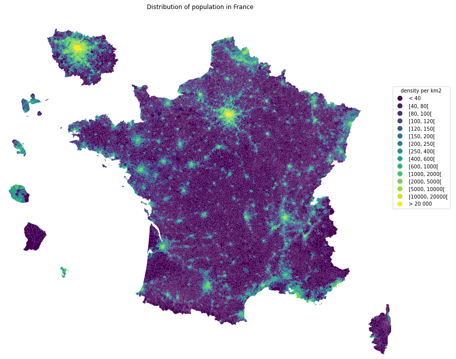
Example - Population Map
import math

import matplotlib.cm as cm
import matplotlib.pyplot as plt
import numpy as np
import pandas as pd

from pynsee.geodata import get_geodata_list, get_geodata


# get geographical data list
geodata_list = get_geodata_list()
# get departments geographical limits
mapcom = get_geodata("ADMINEXPRESS-COG-CARTO.LATEST:commune").to_crs(epsg=3035)

# area calculations depend on crs which fits metropolitan france but not overseas departements
# figures should not be considered as official statistics
mapcom.attrs["area"] = mapcom.area / 10**6
mapcom = mapcom.to_crs(epsg=3857)

mapcom['REF_AREA'] = 'D' + mapcom['code_insee']
mapcom['density'] = mapcom['population'] / mapcom.attrs["area"]

mapcom = mapcom.transform_overseas(departement=['971', '972', '974', '973', '976', 'NR'],
                          factor=[1.5, 1.5, 1.5, 0.35, 1.5, 1.5])

mapcom = mapcom.zoom(
    departement=["75","92", "93", "91", "77", "78", "95", "94"],
    factor=1.5, startAngle = math.pi * (1 - 3.5 * 1/9))

density_ranges = [
    40, 80, 100, 120, 150, 200, 250, 400, 600, 1000, 2000, 5000, 10000, 20000
]

rvals = np.full(len(mapcom), "< 40", dtype=object)

list_ranges = ["< 40"]

for rmin, rmax in zip(density_ranges, density_ranges[1:]):
    range_string = f"[{rmin}, {rmax}["
    list_ranges.append(range_string)

    rvals[(mapcom.density >= rmin) & (mapcom.density < rmax)] = range_string

rvals[mapcom.density.values > density_ranges[-1]] = "> 20 000"

list_ranges.append("> 20 000")

mapcom.loc[:, "range"] = pd.Categorical(rvals, ordered=True, categories=list_ranges)

fig, ax = plt.subplots(1, 1, figsize=(15, 15))
lgd = {'bbox_to_anchor': (1.1, 0.8), 'title': 'density per km2'}
mapcom.plot(column="range", cmap=cm.viridis, legend=True, ax=ax, legend_kwds=lgd)
ax.set_axis_off()
ax.set(title='Distribution of population in France')
plt.show()

fig.savefig('pop_france.svg',
            format='svg', dpi=1200,
            bbox_inches = 'tight',
            pad_inches = 0)
How to avoid proxy issues ?
# Use the proxy_server argument of the init_conn function to change the proxy server address
from pynsee.utils import init_conn
init_conn(sirene_key="my_sirene_key",
          http_proxy="http://my_proxy_server:port",
          https_proxy="http://my_proxy_server:port")

# Beware : any change to the keys should be tested after having cleared the cache
# Please do : from pynsee.utils import *; clear_all_cache()

# Alternativety you can use directly environment variables as follows.
# Beware not to commit your credentials!
import os
os.environ['sirene_key'] = 'my_sirene_key'
os.environ['http_proxy'] = "http://my_proxy_server:port"
os.environ['https_proxy'] = "http://my_proxy_server:port"
Support
Feel free to open an issue with any question about this package using the Github repository.
Contributing
All contributions, whatever their forms, are welcome. See CONTRIBUTING.md


Release files for pynsee 0.3.0
For a detailed explanation of source distributions (sdists) and built distributions (wheels), please see the package formats documentation.
Source distribution (sdist)
| File | Size | Uploaded | Provenance | Actions |
|---|---|---|---|---|
| pynsee-0.3.0.tar.gz | 9.8 MB | Without provenance | Details for pynsee-0.3.0.tar.gz |
Built distribution (wheel)
| File | Interpreter | ABI | Platform | Actions Reset |
|---|---|---|---|---|
| pynsee-0.3.0-py3-none-any.whl | Python 3 | none | any | Details for pynsee-0.3.0-py3-none-any.whl |
Total release size: 19.6 MB
Release files / pynsee-0.3.0.tar.gz
| Download URL | pynsee-0.3.0.tar.gz |
|---|---|
| Size | 9.8 MB |
| Tags | Source |
|
SHA-256 checksum How to use checksums |
8389b0c587478ed97c2f8444fe965e8827b0e8fdfcb55d784d8408491bbc7163
|
|
BLAKE2b-256 checksum How to use checksums |
60b8e7b54b887dde98130727a037e01b77250be175fdd8d47b53e95d3fa48024
|
| Upload date | |
|
Uploaded using Trusted Publishing? What is trusted publishing? |
No |
| Uploaded via |
twine/6.2.0 CPython/3.9.25
|
Release files / pynsee-0.3.0-py3-none-any.whl
| Download URL | pynsee-0.3.0-py3-none-any.whl |
|---|---|
| Size | 9.8 MB |
| Tags | Python 3 |
|
SHA-256 checksum How to use checksums |
df742645ade7ffac7b8a25d24b95e9d7b38ba84fffd2bad7765da3daca6c675a
|
|
BLAKE2b-256 checksum How to use checksums |
276d2cd644fadb62f6fbcc60a628668c35db53a2dd74c2512eb27776323f92f8
|
| Upload date | |
|
Uploaded using Trusted Publishing? What is trusted publishing? |
No |
| Uploaded via |
twine/6.2.0 CPython/3.9.25
|
Security for pynsee 0.3.0
Provenance
Provenance describes where a file came from. On PyPI, provenance is shared via attestations, which provide a verifiable record of the build or publishing details. View details, limitations and caveats.
No provenance found
None of the files in this release were uploaded with provenance metadata.
A note on package security
PyPI is a repository for distributing packages, not a service for auditing them. While third-party security researchers and our staff do their best to detect and remove malicious packages, PyPI cannot guarantee the quality, security or suitability of any given package.
To learn more about protecting yourself from malicious actors, visit our package security documentation.














