
PyWorldAtlas: offline world geography for Python
Offline country profiles, physical geography, optional 3D maps, distances, and learning tools for Python.




248 profiles · 248 optional 3D maps · 6,265 populated places · 0 core runtime dependencies
Documentation · Quickstart · Playground · 3D maps · Examples · API reference
No installation needed: open the browser playground and run the guided Python examples.
PyWorldAtlas is an offline world-geography Python package built around one bundled, source-aware database. It turns country profiles, physical geography, cities, distances, borders, optional 3D maps, and learning tools into ordinary Python objects for developers, classrooms, and curious learners. No API key is required, and installed features work offline.
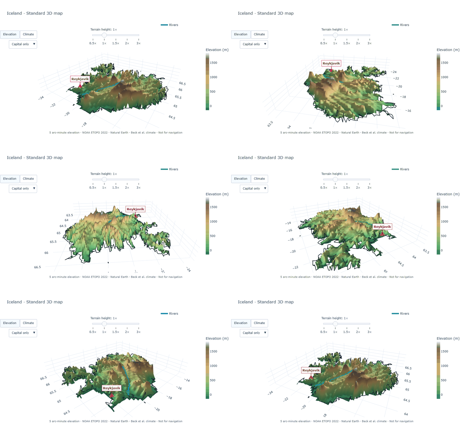
One complete rotation of Iceland rendered by the Standard map edition with elevation, coastline, Reykjavík, a river overlay, and source notes. Select the animation for the map guide.
Install
python -m pip install pyworldatlas
PyWorldAtlas supports Python 3.10 through 3.14. The installed package works offline and has no third-party runtime dependencies.
Confirm the installation or make a quick terminal lookup:
pyworldatlas --version
pyworldatlas country Japan
pyworldatlas search guinea
The command is a small companion to the Python API. It reads the same bundled
database and prints concise messages instead of Python tracebacks for ordinary
lookup errors. Run pyworldatlas --help for every command.
Add the recommended global 3D map edition when you want interactive terrain:
python -m pip install "pyworldatlas[maps]"
Use pyworldatlas[maps-overview] for the smaller Overview edition. Map data is
optional, so the core installation stays unchanged. To replace an older
installation, add --upgrade to the same command.
Meet a country
from pyworldatlas import Atlas

with Atlas() as atlas:
    brazil = atlas.country("Brazil")
    print(brazil.summary())
🇧🇷 Brazil · Brasil
Formal name: Federative Republic of Brazil
Capital: Brasília
Location: Americas · South America
Population snapshot: 209,469,333
Currency: Brazilian Real (BRL, R$)
Languages: English (en), Spanish (es), French (fr), Portuguese (pt-BR)
Anthem title: Hino Nacional Brasileiro · Brazilian National Anthem
Motto: Ordem e Progresso · Order and Progress
Highest point: Pico da Neblina (2,994 m)
Dominant climate class: Aw · Tropical, savannah
Source-listed rivers: Amazon, Río de la Plata/Paraná, Tocantins
Source-listed lakes: Lagoa dos Patos, Lagoa Mirim
Atlas opens a bundled, read-only SQLite database. Results are immutable,
typed models rather than loosely structured dictionaries, and loaded records
remain usable after the atlas is closed.
Open the terrain
from pyworldatlas import Atlas

with Atlas() as atlas:
    atlas.map("Iceland").show(auto_rotate=True)
The one-line call opens a local, rotatable 3D map in the default browser with
elevation, Köppen-Geiger climate coloring, rivers, the country outline, and the
primary capital. Adjust terrain height, show every bundled river name, or hide
labels for a clean presentation view. Play or pause rotation, adjust its speed,
and download a high-resolution PNG of the current angle. The viewer and data
remain offline after installation. Use
atlas.map("Iceland").write_html("iceland-map.html", auto_rotate=True) to
create a standalone rotating document for a lesson or presentation.
Compare the map editions and learn the API.
What you can explore
| Area | Included capabilities |
|---|---|
| Country profiles | Codes, names, capitals, population, currencies, languages, timezones, postal formats, anthem titles, reviewed mottos, and demonyms |
| Names and writing systems | English identities, selected local-language names, scripts, reviewed official forms, and source-provided romanization |
| Physical geography | Land and water area, coastline, elevation extremes, rivers, lakes, and climate summaries |
| Interactive maps | Optional offline 3D elevation and climate surfaces for all 248 profiles, with rotation and speed controls, crisp PNG export, terrain-height settings, and selectable labels |
| Places and measurement | 6,265 cities and capitals with search, nearby-place discovery, readable coordinates, distance, compass direction, bearing, and midpoint calculations |
| Land connections | Reviewed neighbors, shared neighbors, shortest border paths, crossings, and connected components |
| Learning tools | Readable profiles, stable samples, flashcards, deterministic multiple-choice questions, rankings, discovery cards, and Unicode-preserving JSON |
Explore with small, readable programs
Look up countries by familiar name or standard code:
with Atlas() as atlas:
    assert atlas.country("Japan") == atlas.country("JP")
    assert atlas.country("JPN") == atlas.country("392")
    print(atlas.country("Japan").name_in("ja"))
Measure and connect places:
with Atlas() as atlas:
    tokyo = atlas.city("Tokyo", country="JP")
    paris = atlas.city("Paris", country="FR")

    print(tokyo.coordinates.format())
    print(tokyo.coordinates.dms())
    print(f"{atlas.distance_between(tokyo, paris):,.0f} km")
    print(tokyo.coordinates.compass_direction_to(paris.coordinates))

    nearby = atlas.nearest_cities(tokyo, within_country="JP", limit=3)
    print([result.city.name for result in nearby])

    route = atlas.border_path("Portugal", "China")
    print(" → ".join(route.names))
Build a repeatable lesson:
with Atlas() as atlas:
    questions = atlas.quiz(topic="local_names", count=5, seed=42)

    for question in questions:
        print(question.prompt)
        for number, choice in enumerate(question.choices, 1):
            print(f"  {number}. {choice}")
        print("Answer:", question.answer_number)
Distances are great-circle surface measurements, not road or flight routes. Border paths use the reviewed land-border graph and do not infer maritime or boundary geometry.
Built for learning
- Offline: lessons and programs do not depend on an external service.
- Repeatable: seeded samples, flashcards, and quizzes produce stable results.
- Source-aware: provenance and coverage limits are documented.
- Beginner-friendly: common tasks use small Python objects and methods.
- Honest about missing data: unavailable values remain
Noneor empty tuples.
The project provides factual geography and transparent calculations, not political commentary or opinion. Read the educational and neutrality policy for the formal publication standard.
Coverage at a glance
Library 0.9.5 includes dataset 2026.07.22.7 and schema 7.
| Dataset area | Coverage |
|---|---|
| Countries and areas | 248 |
| Primary capitals | 241 / 248 |
| Populated places | 6,265 |
| Selected local-language identities | 248 / 248 |
| Anthem titles | 234 / 248 |
| Reviewed land-border relationships | 319 |
| Highest and lowest points | 240 / 248 |
| Köppen-Geiger climate profiles | 241 / 248 |
| Overview and Standard map coverage | 248 / 248 each |
See the generated project status for complete coverage and data quality for interpretation limits.
Data and trust
Field families use defined source roles rather than one unreviewed compilation. The builder retains source snapshots, checksums, review decisions, and exact coverage gates. Sources include United Nations M49, GeoNames, Unicode CLDR, UNGEGN, Natural Earth, the CIA World Factbook, Wikidata, IANA registries, the Beck et al. Köppen-Geiger dataset, and NOAA NCEI ETOPO 2022.
- Data sources and freshness
- Data quality and limitations
- Educational purpose and editorial policy
- Third-party notices
Documentation and community
- Run Python in the browser
- Try the classroom-friendly learning lab
- Browse complete recipes
- Read the country-profile guide
- Explore physical geography
- Open interactive 3D maps
- Review the API
- See the roadmap
Questions, factual corrections, documentation improvements, and focused code contributions are welcome. Start with CONTRIBUTING.md, follow the code of conduct, and report security concerns through SECURITY.md.
Development
python maintain.py bootstrap
python maintain.py check
maintain.py check runs tests, builds the core and optional-map distributions,
installs the wheels in isolation, renders an offline map, executes examples,
builds strict documentation and doctests, and audits the release contents.
License
PyWorldAtlas code is available under the MIT License. Bundled data retains its original terms and attribution; see THIRD_PARTY_NOTICES.md.
1 maintainer

Release files for pyworldatlas 0.9.5
For a detailed explanation of source distributions (sdists) and built distributions (wheels), please see the package formats documentation.
Source distribution (sdist)
| File | Size | Uploaded | |
|---|---|---|---|
| pyworldatlas-0.9.5.tar.gz | 602.4 kB | Details |
Built distribution (wheel)
| File | Interpreter | ABI | Platform | Reset |
|---|---|---|---|---|
| pyworldatlas-0.9.5-py3-none-any.whl | Python 3 | none | any | Details |
Total release size: 1.2 MB
Release files / pyworldatlas-0.9.5.tar.gz
| Download URL | pyworldatlas-0.9.5.tar.gz |
|---|---|
| Size | 602.4 kB |
| Tags | Source |
|
SHA-256 checksum How to use checksums |
3376d8c9b67393236d0fc95d2052e2bd80d5e1fbcf87ceeae298ad54b75a622d
|
|
BLAKE2b-256 checksum How to use checksums |
ec5daef3808605461dd5ee19ad331e8056fdd9d17f9b69a322990022d06c5366
|
| Upload date | |
|
Uploaded using Trusted Publishing? What is trusted publishing? |
Yes |
| Uploaded via |
twine/7.0.0 CPython/3.13.14
|
Provenance
Provenance describes where a file came from. On PyPI, provenance is shared via attestations, which provide a verifiable record of the build or publishing details. View details, limitations and caveats.


PyPI Publish Attestation
PyPI verified that this artifact, at this checksum, originated from the publisher listed below.
Signed by GitHub Actions, verified by PyPI on Aug 21, 2026.
Transparency logRelease files / pyworldatlas-0.9.5-py3-none-any.whl
| Download URL | pyworldatlas-0.9.5-py3-none-any.whl |
|---|---|
| Size | 566.2 kB |
| Tags | Python 3 |
|
SHA-256 checksum How to use checksums |
3e891fc66559a233b88f336a2f8a0a7498cedd2616ab108218dfa48d82c57fb4
|
|
BLAKE2b-256 checksum How to use checksums |
608b8c928b8907f53f557908f3aac3c3b91485db425e7ad1159d16d80f96b08d
|
| Upload date | |
|
Uploaded using Trusted Publishing? What is trusted publishing? |
Yes |
| Uploaded via |
twine/7.0.0 CPython/3.13.14
|
Provenance
Provenance describes where a file came from. On PyPI, provenance is shared via attestations, which provide a verifiable record of the build or publishing details. View details, limitations and caveats.
PyPI Publish Attestation
PyPI verified that this artifact, at this checksum, originated from the publisher listed below.
Signed by GitHub Actions, verified by PyPI on Aug 21, 2026.
Transparency log













