
RANGE 🌎 — Multi-Resolution Geo-Embeddings for Any Location
Retrieval Augmented Neural Fields for Multi-Resolution Geo-Embeddings (CVPR 2025)
📄 Paper (arXiv:2502.19781) · 💻 Code (github.com/mvrl/RANGE) · 🤗 Models & Database (HuggingFace) · 🔬 MVRL Lab
RANGE turns geographic coordinates (longitude, latitude) into rich, general-purpose embedding vectors that you can drop into any downstream model — species distribution, climate, land cover, population, housing prices, or any task where where matters.
How it works
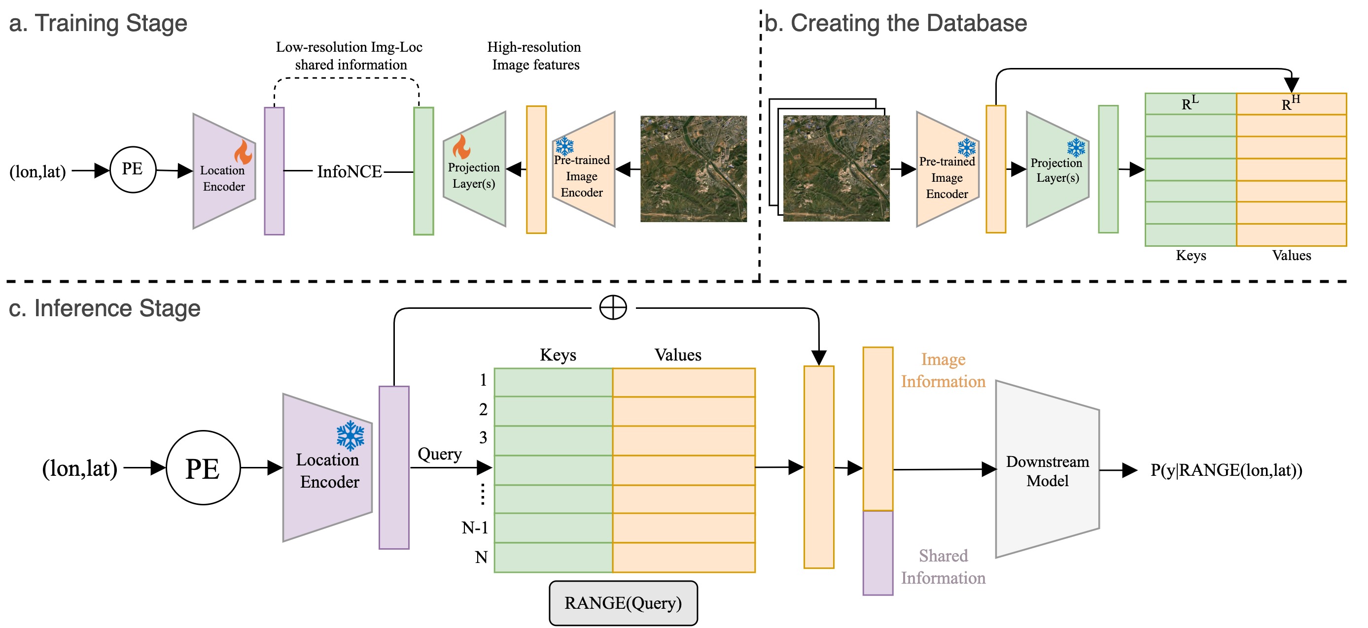
Location encoders like SatCLIP learn a smooth neural field over the globe, which captures low-frequency spatial patterns but washes out fine detail. RANGE is a retrieval-augmented location encoder: for a query location, it estimates the visual features a satellite image at that location would have, by retrieving from a pre-built database of (location, SatCLIP embedding, image embedding) triplets:
- RANGE retrieves database entries whose semantic (SatCLIP) embeddings are similar to the query's, and aggregates their high-resolution image embeddings.
- RANGE+ additionally retrieves by geographic proximity on the sphere and blends the two estimates with a weight β — moving β trades off between smooth, low-frequency embeddings (β→0) and sharp, high-frequency ones (β→1), giving you multi-scale control at inference time.
The final embedding concatenates this estimated high-resolution visual feature (1024-d) with the smooth SatCLIP location feature (256-d) into a 1280-d vector. Across 7 downstream benchmarks (biome, ecoregion, country, temperature, elevation, population, housing), RANGE outperforms state-of-the-art location encoders such as SatCLIP, GeoCLIP, CSP, and SINR — see the paper for full tables.
Installation
pip install rangegeo
Dependencies are minimal: torch, numpy, einops, huggingface_hub.
Usage
from rangegeo import RANGE

# downloads the SatCLIP backbone + RANGE database from HuggingFace on first use
model = RANGE("RANGE+", db="large", beta=0.5)   # or "RANGE"

# coordinates are (longitude, latitude) in degrees
embeddings = model.encode([
    [-90.19, 38.63],   # St. Louis
    [ 85.32, 27.72],   # Kathmandu
])
print(embeddings.shape)  # (2, 1280) numpy float32
That's it — encode() accepts any (N, 2) array-like of (lon, lat) degrees,
batches internally (default batch size 10000), and runs on GPU automatically
when available.
Options:
| argument | values | meaning |
|---|---|---|
model_name |
"RANGE+" (default), "RANGE" |
RANGE+ adds geographic retrieval + β control |
db |
"large" (default), "med" |
retrieval database (~0.9 GB / ~0.45 GB, cached after first download) |
beta |
0.0 – 1.0 (default 0.5) | RANGE+ smoothness↔detail trade-off |
device |
"cuda", "cpu" |
default: auto |
pretrained_path, db_path |
local paths | use a fine-tuned SatCLIP backbone or a custom/regenerated database |
The model is a regular torch.nn.Module: inside a torch pipeline you can call
model(coords_tensor) directly with an (N, 2) double tensor of (lon, lat).
For training code, evaluation benchmarks, database generation
(generate_db.py), and baseline encoders, see the
GitHub repository.
Citation
@article{dhakal2025range,
  title={RANGE: Retrieval Augmented Neural Fields for Multi-Resolution Geo-Embeddings},
  author={Dhakal, Aayush and Sastry, Srikumar and Khanal, Subash and Ahmad, Adeel and Xing, Eric and Jacobs, Nathan},
  booktitle={Computer Vision and Pattern Recognition},
  year={2025},
  organization={IEEE/CVF}
}
License
MIT — © the RANGE authors (MVRL, Washington University in St. Louis).
1 maintainer

Download files
Download the file for your platform. If you're not sure which to choose, learn more about installing packages.
Source Distribution
Built Distribution
Filter files by name, interpreter, ABI, and platform.
If you're not sure about the file name format, learn more about wheel file names.
Copy a direct link to the current filters
File details
Details for the file rangegeo-0.1.0.tar.gz.
File metadata
- Download URL: rangegeo-0.1.0.tar.gz
- Upload date:
- Size: 2.0 MB
- Tags: Source
- Uploaded using Trusted Publishing? No
- Uploaded via:
twine/7.0.0 CPython/3.12.9
File hashes
| Algorithm | Hash digest | |
|---|---|---|
| SHA256 |
f964b0e15089b83b22e696d8d433d062fc04140063f15a570efb4490031f2cfe
|
|
| MD5 |
0d8a01a0a468b04f618983a7b7051b3b
|
|
| BLAKE2b-256 |
294094fb50fd973f0b2231dba68b016f5f9085aca34cc8cf1bb3c19f917aa2c4
|
File details
Details for the file rangegeo-0.1.0-py3-none-any.whl.
File metadata
- Download URL: rangegeo-0.1.0-py3-none-any.whl
- Upload date:
- Size: 2.0 MB
- Tags: Python 3
- Uploaded using Trusted Publishing? No
- Uploaded via:
twine/7.0.0 CPython/3.12.9
File hashes
| Algorithm | Hash digest | |
|---|---|---|
| SHA256 |
8d22eba787ac754279088094eb05432bed0e5357fb5a55b40c36df88bc9f1167
|
|
| MD5 |
3c0c387de4e1bfc421f4ffcd3bd28f35
|
|
| BLAKE2b-256 |
c224e2b74654af0a3dd1fffe068ffec80c849ec01f76ac00ec5e4d7585d0b581
|







