
reflex-map3d
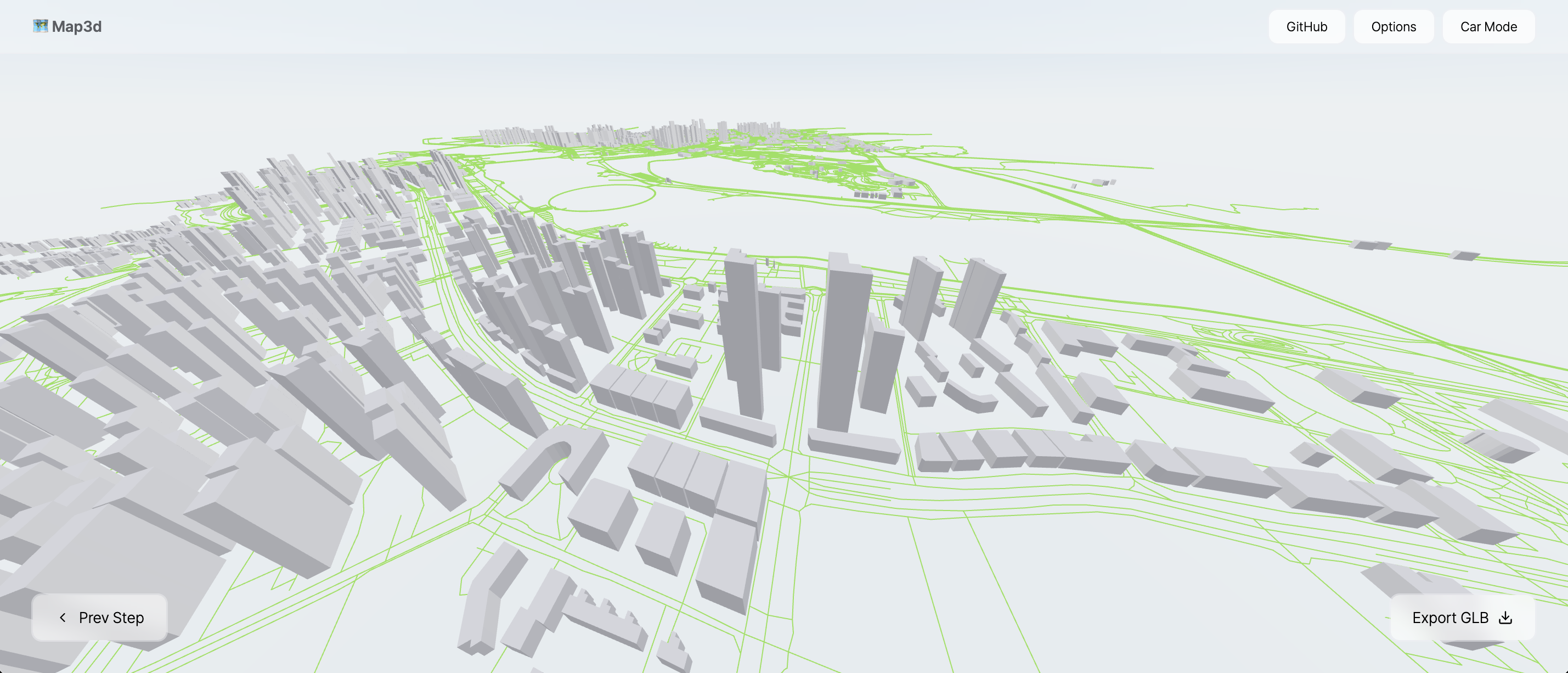
Generate a real-world 3D city from OpenStreetMap data, inside a Reflex app.
This is a port of cartesiancs/map3d — a React-Three-Fiber 3D building mapper — to Reflex custom components. You pick an area on a Leaflet map, the buildings and roads come from the Overpass API, the scene is extruded in three.js, and the result can be exported as a GLB file for Blender, Unreal, a digital twin, drone survey work or GPS-marker overlays.
Install
pip install reflex-map3d
The npm side (three, @react-three/fiber, @react-three/drei,
react-leaflet, leaflet) is installed automatically by Reflex the first time
the app compiles. There is no npm package to add by hand: the React sources ship
inside the wheel and are compiled by the app's own Vite build.
Quick start
The whole workflow in one component:
import reflex as rx
from reflex_map3d import map3d_viewer


def index() -> rx.Component:
    return map3d_viewer(height="100vh")


app = rx.App()
app.add_page(index)
That gives you the upstream map3d experience: draw a box, download the area, orbit the city, export GLB.
The three components
| Component | Factory | What it does |
|---|---|---|
Map3dAreaSelector |
map3d_area_selector |
Leaflet map, drag-to-select a bounding box |
Map3dScene |
map3d_scene |
The react-three-fiber city: buildings, roads, export |
Map3dViewer |
map3d_viewer |
Both of the above plus the step-by-step shell |
Use the viewer when you want the finished product; use the selector and the scene separately when the data should live in your Reflex state.
Composing the pieces
The interesting pattern: the bounding box goes to the backend, Python queries Overpass, and the buildings come back as ordinary state. Nothing in the browser talks to Overpass, so you can cache, filter, enrich or persist the data first.
from typing import Any

import reflex as rx
from reflex_map3d import fetch_buildings_async, map3d_area_selector, map3d_scene


class State(rx.State):
    bbox: dict[str, float] | None = None
    buildings: list[dict[str, Any]] = []
    export_trigger: int = 0

    @rx.event
    def select(self, bbox: dict[str, float]):
        self.bbox = bbox

    @rx.event(background=True)
    async def load(self):
        async with self:
            area = self.bbox
        if not area:
            return
        found = await fetch_buildings_async(area)
        async with self:
            self.buildings = found

    @rx.event
    def export_glb(self):
        self.export_trigger += 1


def index() -> rx.Component:
    return rx.vstack(
        map3d_area_selector(on_select=State.select, height="400px"),
        rx.hstack(
            rx.button("Load", on_click=State.load),
            rx.button("Export GLB", on_click=State.export_glb),
        ),
        map3d_scene(
            bbox=State.bbox,
            buildings=State.buildings,
            export_trigger=State.export_trigger,
            height="600px",
        ),
    )
Letting the browser fetch instead
If you would rather not proxy the data through Python, set auto_fetch:
map3d_scene(
    bbox={"north": 40.762, "south": 40.750, "east": -73.974, "west": -73.988},
    auto_fetch=True,
    fetch_roads_from_overpass=True,
    height="600px",
)
Data shapes
A bounding box is always {"north": float, "south": float, "east": float, "west": float}.
A building or road is:
{
    "id": 12345,
    "type": "way",
    "tags": {"building": "yes", "height": "31", "name": "…"},
    "geometry": [{"lat": 40.7581, "lng": -73.9855}, ...],
}
Anything matching that shape renders — the geometry does not have to come from
OpenStreetMap. Building height is read from the height tag, or from
building:levels × level_height, falling back to default_height.
Python helpers
from reflex_map3d import (
    BBox,                    # normalised bounding box with .center, .span, .to_dict()
    to_bbox,                 # coerce any bbox-ish value into a BBox
    buildings_query,         # the Overpass QL, if you want to run it yourself
    roads_query,
    fetch_buildings,         # blocking
    fetch_roads,
    fetch_buildings_async,   # for @rx.event(background=True)
    fetch_roads_async,
    to_features,             # raw Overpass elements -> the render shape
    OverpassError,           # raised when every endpoint refuses
)
Requests are POSTed with the query in the data form field, as the Overpass API
documents — sending it as a raw body is what earns a 406 Not Acceptable from
the public endpoint. When that endpoint rate-limits (429) or times out
(504), the call falls through to FALLBACK_OVERPASS_URLS before giving up.
Set overpass_url to your own instance and no mirror is tried.
BBox.span is the dlat + dlng heuristic map3d uses to warn about large areas
(it warns above 0.1). Overpass is a shared free service — keep areas small,
cache what you fetch, and consider pointing overpass_url at your own instance
for anything beyond a demo.
Props
map3d_area_selector
| Prop | Type | Default | Notes |
|---|---|---|---|
center |
list[float] |
[40.8, -73.95] |
[lat, lng] the map opens at |
zoom |
int |
13 |
|
tile_url |
str |
OSM raster tiles | Any XYZ template |
attribution |
str |
OSM attribution | Keep it when using OSM tiles |
min_zoom / max_zoom |
int |
2 / 19 |
|
rectangle_color |
str |
"#1f6feb" |
Selection stroke |
show_controls |
bool |
True |
The built-in mode/clear buttons |
select_label / drag_label / clear_label |
str |
English labels | For translated UIs |
Events: on_select(bbox), on_clear(), on_mode_change(drag_enabled).
map3d_scene
| Prop | Type | Default | Notes |
|---|---|---|---|
bbox |
dict |
None |
The area the projection is centred on |
buildings / roads |
list[dict] |
[] |
Features to render |
auto_fetch |
bool |
False |
Fetch buildings in the browser |
fetch_roads_from_overpass |
bool |
False |
Fetch roads in the browser |
overpass_url / overpass_timeout |
str / int |
public endpoint / 25 |
|
scale |
int |
51000 |
World units per degree of latitude |
default_height / level_height |
float |
10.0 / 2.2 |
Metres |
building_color / highlight_color |
str |
"#9da0a3" / "#007bff" |
|
road_color / road_width / road_elevation |
"#34f516" / 1.0 / 0.1 |
||
show_roads / show_tooltip / show_sky / show_environment |
bool |
True |
|
environment_preset |
str |
"city" |
drei preset name |
background |
str |
None |
Solid canvas colour |
orbit_controls |
bool |
True |
|
drive_mode / drive_speed / drive_color |
False / 3.0 / "orange" |
WASD driving | |
camera_fov / camera_near / camera_far / camera_position |
90 / 0.1 / 7000 / [0, 120, 260] |
||
auto_frame |
bool |
True |
Pull the camera back to fit the area |
ambient_intensity |
float |
π/2 |
|
export_trigger |
int |
0 |
Increment it to export a GLB |
export_filename |
str |
"scene.glb" |
Events: on_building_click(info), on_building_hover(info), on_export(info),
on_load(info), on_error(message).
map3d_viewer
Takes the selector props (center, zoom, tile_url, attribution), most of
the scene's styling props, plus include_roads, max_span, title and
description. Events: on_select, on_load, on_export, on_step_change,
on_building_click, on_error.
Exporting GLB
Export is edge-triggered: bump export_trigger and the browser downloads a
binary GLB of everything in the scene. on_export then fires with
{"filename": ..., "bytes": ...}. The file never round-trips through the
backend, so large cities do not cost you any server bandwidth.
Notes and caveats
- Data accuracy. Straight from upstream: OpenStreetMap height values are
often missing or wrong, so buildings fall back to
default_height. Treat the output as an approximation, not a survey. - Sizing. Every component fills its container, so give it a height
(
height="600px",height="100vh", …).create()applies a sensible default if you forget. - The drei environment map (
show_environment=True) streams an HDR file from a CDN. Behind a firewall or a strict CSP that fetch fails; the scene catches it and renders without image-based lighting rather than blanking out. Setshow_environment=Falseto skip it entirely. - Server-side rendering. All three components are
NoSSRComponents — three.js and Leaflet both touchwindowon import — so they mount on the client only. - Rate limits. The public Overpass endpoint throttles aggressively. Cache.
Demo app
cd map3d_demo
uv pip install -r requirements.txt
uv run reflex run
Four pages: the composed selector + backend fetch, the all-in-one viewer, preset city bounding boxes, and an offline page that renders synthetic geometry with no network at all.
Credits
- Upstream project: cartesiancs/map3d by Hyeong Jun Huh, MIT licensed.
- Map data © OpenStreetMap contributors, ODbL.
License
MIT
1 maintainer

Download files
Download the file for your platform. If you're not sure which to choose, learn more about installing packages.
Source Distribution
Built Distribution
Filter files by name, interpreter, ABI, and platform.
If you're not sure about the file name format, learn more about wheel file names.
Copy a direct link to the current filters
File details
Details for the file reflex_map3d-0.1.1.tar.gz.
File metadata
- Download URL: reflex_map3d-0.1.1.tar.gz
- Upload date:
- Size: 41.5 kB
- Tags: Source
- Uploaded using Trusted Publishing? Yes
- Uploaded via:
twine/7.0.0 CPython/3.13.14
File hashes
| Algorithm | Hash digest | |
|---|---|---|
| SHA256 |
247894a1f73213124f26bb4a13eb706d425e89cc0f5efe6b545db751323583f5
|
|
| MD5 |
0fbbc1ecdee9692d48780cea8b8afdff
|
|
| BLAKE2b-256 |
82a308818e839b576ff53702d3467887bae7986f766129d974801e3042d8c55f
|
Provenance
The following attestation bundles were made for reflex_map3d-0.1.1.tar.gz:
Publisher:
release.yml on ecrespo/reflex-map3d
-
Statement:
-
Statement type:
https://in-toto.io/Statement/v1 -
Predicate type:
https://docs.pypi.org/attestations/publish/v1 -
Subject name:
reflex_map3d-0.1.1.tar.gz -
Subject digest:
247894a1f73213124f26bb4a13eb706d425e89cc0f5efe6b545db751323583f5 - Sigstore transparency entry: 2810592709
- Sigstore integration time:
-
Permalink:
ecrespo/reflex-map3d@096415f18ec846cf67b9ae4d5fc26a4fa612ae22 -
Branch / Tag:
refs/heads/main - Owner: https://github.com/ecrespo
-
Access:
public
-
Token Issuer:
https://token.actions.githubusercontent.com -
Runner Environment:
github-hosted -
Publication workflow:
release.yml@096415f18ec846cf67b9ae4d5fc26a4fa612ae22 -
Trigger Event:
push
-
Statement type:
File details
Details for the file reflex_map3d-0.1.1-py3-none-any.whl.
File metadata
- Download URL: reflex_map3d-0.1.1-py3-none-any.whl
- Upload date:
- Size: 44.4 kB
- Tags: Python 3
- Uploaded using Trusted Publishing? Yes
- Uploaded via:
twine/7.0.0 CPython/3.13.14
File hashes
| Algorithm | Hash digest | |
|---|---|---|
| SHA256 |
a9fe58226f8b8de4740c23182e3f76341a16754452048c34a5b43a2b704b185b
|
|
| MD5 |
277f97c13031de00aacbaee44c905b3f
|
|
| BLAKE2b-256 |
ecce72f33e006bf5244c0d4d44c90342126b6728e6a7a1ec082ebd27feaf8103
|
Provenance
The following attestation bundles were made for reflex_map3d-0.1.1-py3-none-any.whl:
Publisher:
release.yml on ecrespo/reflex-map3d
-
Statement:
-
Statement type:
https://in-toto.io/Statement/v1 -
Predicate type:
https://docs.pypi.org/attestations/publish/v1 -
Subject name:
reflex_map3d-0.1.1-py3-none-any.whl -
Subject digest:
a9fe58226f8b8de4740c23182e3f76341a16754452048c34a5b43a2b704b185b - Sigstore transparency entry: 2810592725
- Sigstore integration time:
-
Permalink:
ecrespo/reflex-map3d@096415f18ec846cf67b9ae4d5fc26a4fa612ae22 -
Branch / Tag:
refs/heads/main - Owner: https://github.com/ecrespo
-
Access:
public
-
Token Issuer:
https://token.actions.githubusercontent.com -
Runner Environment:
github-hosted -
Publication workflow:
release.yml@096415f18ec846cf67b9ae4d5fc26a4fa612ae22 -
Trigger Event:
push
-
Statement type:













