Catchmentwide erosion rate calculator

Project description
NEW in version 1.4 (released 2025-06-04):
Use funtion reproject() to reproject all raster datasets to match the DEM. This
may fix issues such as to missing projection in the shielding raster or minor
mismatches in the raster resolutions.
Updated lithological ('quartz') weighing functions.
Use functions get_ages_from_server() and get_erates_from_server() to obtain
point-based exposure ages and erosion rates calculated by the online calculator
from sample data in your Excel spreadsheet and save the results as spreadsheet.
See updated documentation quickstart.ipynb
Catchmentwide erosion rates with riversand
riversand is a python package to calculate catchmentwide erosion rates from
cosmogenic nuclide concentrations in river sand samples. The program computes
the hypsometric statistics of the catchment area from a digital elevation model.
It uses the online erosion rate calculator by Greg Balco
(e.g. http://stoneage.hzdr.de/) to determine predicted
nuclide concentrations $N$ for given erosion rates $E$, and calculates
the erosion rate that corresponds to the measured nuclide concentration from a
polynomial fit $N(E)$.
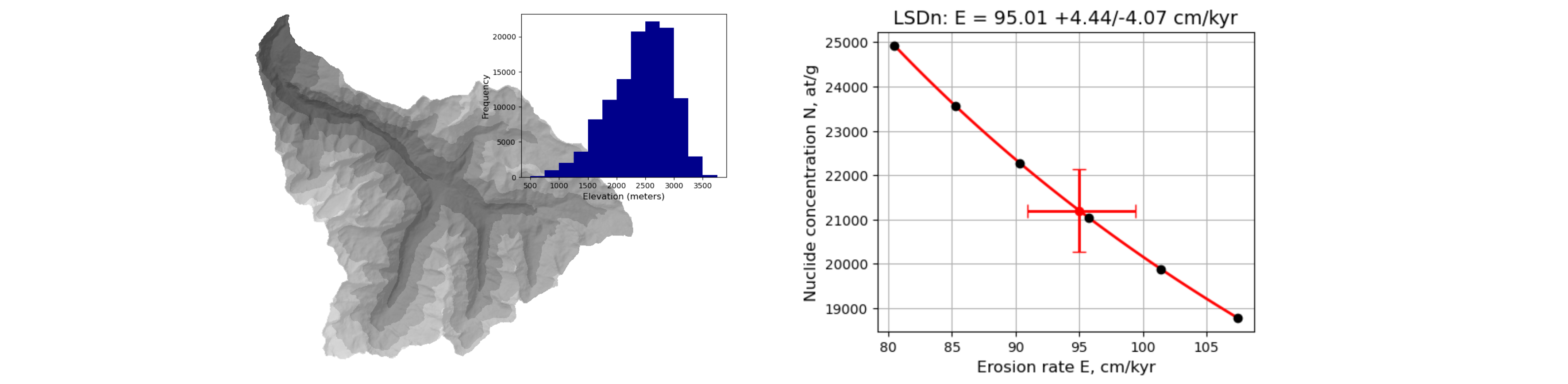
The method works for in situ Be-10 and Al-26 data. It is fast (few seconds for one catchment) for all production scaling methods implemented in the online calculator (St: Lal 1991/Stone 2000; Lm: Lal/Stone with a geomagnetic correction after Nishiizumi et al. 1989; LSDn: Lifton et al. 2014) and independent of the catchment size or the resolution of the digital elevation model. It is considered robust for catchments up to approx. 600 km x 600 km; for larger catchments the effect of latitude on cosmogenic production may become significant.
The approach is described in:
Stübner, K., Balco, G., and Schmeisser, N. (2023). Riversand: a new tool for efficient computation of catchmentwide erosion rates. Radiocarbon. (link).
Definitely check out the documentation of the online calculator (e.g. here or here) and the publication Balco et al. (2008) before using this calculator.
Documentation
quickstart.ipynbstep_by_step.ipynbtest_data/: geotiffs of a 35m-resolution digital elevation model, a topographic shielding raster generated with TopoToolbox and a binary raster indicating quartz-bearing and quartz-free lithologies; shapefiles with catchment outlines; a spreadsheet with sample data.
Installation
Install latest version of riversand by running:
$ pip install riversand==1.4
Requirements
- numpy, scipy, pandas, xarray
- rasterio, fiona, pyproj
- odfpy, openpyxl
- matplotlib
License
Release history Release notifications | RSS feed


Download files
Download the file for your platform. If you're not sure which to choose, learn more about installing packages.
Source Distribution
Built Distribution
Filter files by name, interpreter, ABI, and platform.
If you're not sure about the file name format, learn more about wheel file names.
Copy a direct link to the current filters
File details
Details for the file riversand-1.4.tar.gz.
File metadata
- Download URL: riversand-1.4.tar.gz
- Upload date:
- Size: 60.1 kB
- Tags: Source
- Uploaded using Trusted Publishing? No
- Uploaded via: twine/6.1.0 CPython/3.11.12
File hashes
| Algorithm | Hash digest | |
|---|---|---|
| SHA256 |
cbad6da19a34b067c6ba26e7503c9a0be7e583bf20f993e4c755cf56cbab8c3b
|
|
| MD5 |
772eac30c7156411a3e513f950db4dc4
|
|
| BLAKE2b-256 |
0275c69be78608599194d590b7ed4a89bb6ef57979962490df0a77fee0c2b8ce
|
File details
Details for the file riversand-1.4-py3-none-any.whl.
File metadata
- Download URL: riversand-1.4-py3-none-any.whl
- Upload date:
- Size: 62.2 kB
- Tags: Python 3
- Uploaded using Trusted Publishing? No
- Uploaded via: twine/6.1.0 CPython/3.11.12
File hashes
| Algorithm | Hash digest | |
|---|---|---|
| SHA256 |
623ec8a301c0499f41498f684c292ee3ad43eb61b0370ff3ab9cc69f8462ea02
|
|
| MD5 |
1d77f88f5de00ea9c580cb4512c170ec
|
|
| BLAKE2b-256 |
63ce409b3c66a5e209ed37e4f9d4b465de85d0891bd220f313a309aff4d64f27
|


