








satprint -- Satellite Terrain to 3D-Printable Models
Pick a place on a map. Get a watertight STL of its terrain and buildings, a multi-color 3MF ready for a multi-material printer, and a GLB with satellite imagery draped over it.
satprint turns real elevation data into a solid relief model scaled to your printer: the terrain on top, four walls and a flat base. Cities can carry their OpenStreetMap buildings, and the multi-color 3MF splits the model into land, water, buildings and a border frame, one filament each.
Documentation: suchanek.github.io/satprint
satellite elevation  ->  heightmap (meters)       ->  STL solid
AWS Terrain Tiles        clamp sea, smooth,           terrain + walls + base
(SRTM, ASTER, GMTED)     scale to mm, exaggerate      + OSM buildings
                                                      + land/water/border 3MF
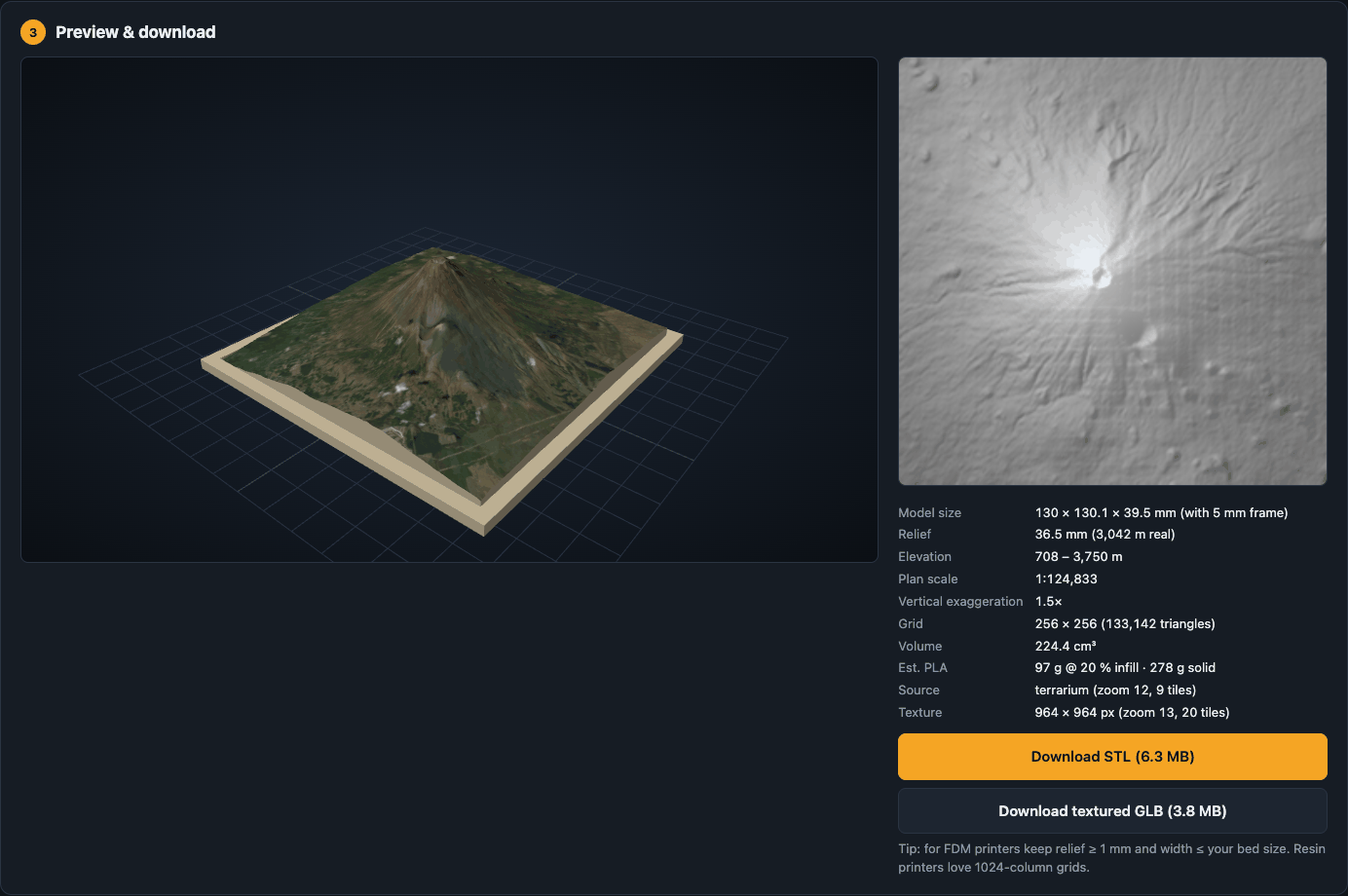
Mount Fuji from real elevation tiles, 120 mm wide with a 5 mm frame, 1.5x exaggeration:
Features
- Real elevation, no API key. Elevation comes from the public
AWS Terrain Tiles set
(SRTM, ASTER, GMTED and others), cached under
~/.cache/satprint/tiles. You can also upload a 16-bit PNG, TIFF or GeoTIFF heightmap, or use a procedural demo terrain that needs no network. - Print-aware output. True plan scale, vertical exaggeration or a fixed relief height, base thickness, sea-level flattening, Gaussian smoothing and grids up to 1024 columns. Each build reports model size, scale, triangle count, volume and an estimated PLA weight.
- Watertight by construction. Every edge is shared by exactly two outward-wound triangles, so slicers (Bambu Studio, PrusaSlicer, Cura, Chitubox) load the STL without repair.
- Buildings from OpenStreetMap, as closed solids standing on the terrain.
Landmark towers keep their setbacks where OSM maps them as
building:partshapes, domes, onion domes, cones and pyramids get their roof shapes, and overlapping footprints are merged so no two solids pass through each other. A few landmarks, such as the Sphere in Las Vegas, get exact shapes. Heights are in true proportion by default, with a multiplier. OpenFreeMap, Overpass or Overture Maps. - Bridges over water from OpenStreetMap, as a raised deck on evenly spaced piers, in the STL, GLB and 3MF. Deck heights are estimated from the banks.
- Roads from OpenStreetMap, as raised strips that follow the terrain, in the STL, GLB and 3MF. Which roads are drawn depends on the model scale.
- Multi-color 3MF. Land, water, buildings, roads and an optional border frame are separate parts of one object, already on filaments 1 to 5 in Bambu Studio. Water is the OSM sea, rivers and lakes, plus the flattened sea.
- Border frame. A rectangular rim around the model, 1 mm above the base by default, in the STL, GLB and 3MF.
- Textured GLB. Satellite imagery draped over the terrain and the roofs, for viewing in Blender, macOS Quick Look or a web viewer. The web preview shows it.
- Search and presets. Search any place by name, or pick one of 70 presets: 40 cities and landmarks, which turn buildings on, and 30 mountains and landscapes.
- Web app, CLI and REST API. Builds run as background jobs, and the page
shows each stage with tile counts. Interactive API docs are at
/docs.
Install
satprint needs Python 3.12 or 3.13. It is on PyPI:
pipx install satprint            # or: pip install satprint
pipx install "satprint[overture]"   # with the Overture Maps building source
From a clone, for development:
git clone https://github.com/suchanek/satprint.git
cd satprint
poetry install                   # add --extras geotiff for GeoTIFF georeferencing
See Installation for Docker.
Run the web app
satprint serve                   # http://127.0.0.1:7417
satprint serve --host 0.0.0.0 --port 7417
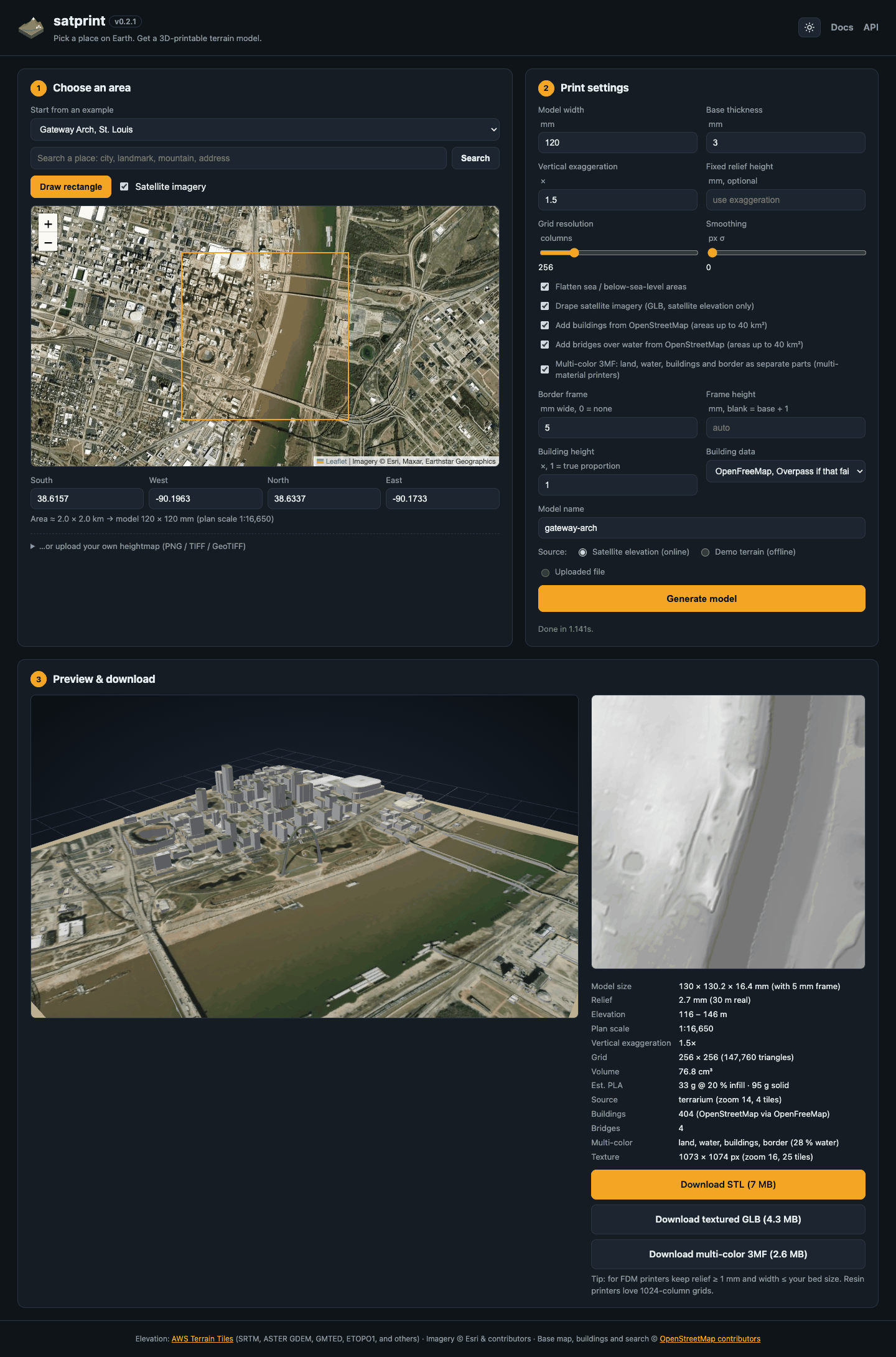
- Choose an area. Search for a place, pick a preset, click Draw rectangle and drag on the map, or type the bounds. Dragging the map afterwards slides it under the rectangle, so you can move the area without redrawing it. The hint line shows the real size of the area and the model it makes.
- Set the print. Model width, base thickness, vertical exaggeration (1.5x to 3x reads well for most landscapes; 1x is true scale) or a fixed relief height. Resolution sets the grid columns: 256 is fine for FDM, 512 to 1024 for resin. Check Add buildings for a city, and Multi-color 3MF plus a Border frame width for a multi-material print.
- Generate. The textured model appears in the 3D preview. Download the STL to print in one color, the 3MF to print in several, or the GLB to view.
After you change the code, restart satprint serve to pick up the change.
Print in several colors
The multi-color 3MF holds up to five parts, in this filament order:
| Filament | Part | Display color |
|---|---|---|
| 1 | land |
green |
| 2 | water |
blue |
| 3 | buildings |
white |
| 4 | roads |
dark gray |
| 5 | border |
dark gray |
Bridges share the buildings part. Parts without geometry are left out, and
the parts after them move up a filament.
To print it on a Bambu printer with an AMS:
- In Bambu Studio, set up one filament per part, up to five, in the left sidebar, or sync them from the AMS.
- Open the 3MF. Bambu Studio reports that it loads "geometry only", as it does for any 3MF it did not write; the part names and filaments still come through.
- To check or change a part's filament, open the object list: in the left sidebar, under Process, click Objects and expand the model.
- Slice. The preview shows each part in its filament's color.
Other slicers open the same parts with every part on filament 1; assign the filaments by hand.
Command line
# Matterhorn, 120 mm wide, 2x exaggeration
satprint build --bbox 45.93 7.58 46.02 7.72 --width 120 --exaggeration 2 -o matterhorn.stl

# Fixed 15 mm relief, smoothed, with a hillshade preview PNG
satprint build --bbox 36.02 -112.25 36.20 -111.95 --relief 15 --smoothing 1 \
               --preview canyon.png -o grand-canyon.stl

# Midtown Manhattan with buildings, plus a textured GLB
satprint build --bbox 40.7414 -73.9997 40.7684 -73.9683 --width 150 \
               --buildings --glb midtown.glb -o midtown.stl

# The Golden Gate Bridge, with piers at most 20 mm apart
satprint build --bbox 37.805 -122.490 37.835 -122.465 --bridges -o golden-gate.stl

# San Francisco with buildings and roads, roads as their own 3MF part
satprint build --bbox 37.745 -122.45 37.775 -122.41 --width 150 --buildings \
               --roads --3mf sf.3mf -o sf.stl

# Venice as a four-color 3MF: land, water, buildings and a 5 mm border frame
satprint build --bbox 45.43 12.32 45.446 12.343 --buildings --frame 5 \
               --3mf venice.3mf -o venice.stl

# From your own DEM in meters, 12 km across
satprint build --file dem.tif --ground-width 12000 -o dem.stl

# Offline demo terrain
satprint build --synthetic -o demo.stl
Bounds are SOUTH WEST NORTH EAST in decimal degrees. The command prints a
JSON summary: elevation range, scale, triangle count, volume and a watertight
check. satprint build --help lists every option.
REST API
| Method | Path | Purpose |
|---|---|---|
GET |
/api/presets |
Named example areas, grouped |
GET |
/api/search?q=... |
Place search; each hit has a bbox |
POST |
/api/upload |
Multipart heightmap upload; returns an upload_id |
POST |
/api/model |
Build a model; returns stats, a preview PNG and download URLs |
POST |
/api/jobs |
Same body as /api/model, built in the background; returns a job_id |
GET |
/api/jobs/{id} |
Job status, current stage with done and total, and the /api/model response as result when done |
GET |
/api/model/{id}/{name}.stl |
Binary STL |
GET |
/api/model/{id}/{name}.glb |
Textured GLB, when glb_url is set |
GET |
/api/model/{id}/{name}.3mf |
Multi-color 3MF, when threemf_url is set ("multicolor": true) |
GET |
/api/model/{id}/heightmap.png |
Hillshade preview |
curl -s localhost:7417/api/model -H 'content-type: application/json' -d '{
  "source": "terrarium",
  "bbox": {"south": 35.28, "west": 138.65, "north": 35.45, "east": 138.82},
  "width_mm": 150, "exaggeration": 1.2, "resolution": 512, "name": "fuji"
}' | python -c 'import json,sys; j=json.load(sys.stdin); print(j["stl_url"], j["info"]["height_mm"])'
How the scaling works
- Plan scale is
width_mm / ground_width_m. The depth follows the true aspect ratio of the area, from great-circle distances along the center lines of the bounding box. - Vertical scale is the plan scale times the exaggeration, so
exaggeration = 1is a true-scale model. Withrelief_mmset, the vertical scale puts the highest point exactly that far above the base, and the effective exaggeration is reported back. - Lakes. Water bodies are set to the lower shore of their outline, since elevation data over water is noisy and can print a lake as a raised plateau.
- Sea level. Samples below 0 m (bathymetry in the source data) are clamped to 0 by default, so coastlines print as a flat plane.
- Buildings use the plan scale for their heights, so
building_scale = 1keeps them in true proportion to the map.
Data sources
| Data | Source | Cache |
|---|---|---|
| Elevation | AWS Terrain Tiles | ~/.cache/satprint/tiles |
| Imagery (GLB texture) | Esri World Imagery | ~/.cache/satprint/imagery |
| Buildings, bridges, roads and water | OpenFreeMap vector tiles, zoom 14, rebuilt from OSM about weekly | ~/.cache/satprint/vtiles |
| Buildings, fallback; roof shapes | Overpass API, 0.01° tiles | ~/.cache/satprint/osm |
| Buildings, optional | Overture Maps GeoParquet on S3, per release | ~/.cache/satprint/overture |
| Place search | Nominatim, one request per second | in memory |
- Buildings. A building with no
heightorbuilding:levelstag gets 8 m. Building parts are extruded from the ground, ignoringmin_height, so nothing floats. Buildings sink 0.3 mm into the terrain so they fuse with it when sliced. Areas are limited to 40 km² with buildings on, and very small footprints are dropped. A building that crosses a vector-tile edge arrives as two solids that meet at the edge. - Bridges. Only bridges over water are built, from the OSM bridge outlines and bridge-tagged road, rail and path lines. Each is cut to the water plus a landing of about 30 m on each bank. OSM has no deck heights, so a landing is flat at the highest ground under it, and the deck blends the landings' heights over the water, at least 1 mm above it. The span is a thin slab, open underneath, on piers at even spacing; they are not the real piers, and there are no towers or cables. Areas are limited to 40 km², as with buildings.
- Roads. Roads are raised 0.4 mm strips, at least 0.8 mm wide, so most are drawn wider than they are. Minor classes are left out of large areas, where they would cover the land. Roads stop at water, buildings and bridges; tunnels, rail and ferries are left out. Areas are limited to 40 km², as with buildings. On rough ground at a fine grid, roads stand up to 0.3 mm taller so they clear the terrain everywhere.
- Roof shapes. Roofs tagged
roof:shapedome, onion, cone or pyramidal get that shape, fromroof:heightorroof:levels, else a hemisphere-like height from the footprint's size. Other roofs are flat. The vector tiles carry no roof tags, so a small Overpass query adds them; if it fails, the roofs are flat and the build says so. A shaped roof starts no lower than the larger flat roofs around it, and smaller parts standing on it, such as a lantern on a dome, stand in a hole cut in the roof, so the solids never pass through each other. - Landmarks. A few buildings that roof tags cannot describe are replaced by exact shapes from published dimensions: the Sphere in Las Vegas, a 157 m sphere cut by the ground at 112 m, and, as meshes with open archways and separate legs, the Gateway Arch, the Eiffel Tower, the Space Needle and Christ the Redeemer. The Arch, the Needle's saucer and the Eiffel Tower's archways are overhangs that may want slicer supports.
- Overture Maps. Choose it with "Building data" or
--building-source overture. It merges OSM with Microsoft and Google footprints, so it finds buildings OSM lacks, and keeps the roof tags. It needs theovertureextra (pip install "satprint[overture]", about 190 MB with pyarrow; the Docker image has it). - Overpass. Choose it with "Building data" in the web app or
--building-source overpasson the CLI, for the latest OSM edits. The default "auto" uses it only if OpenFreeMap fails. Its tiles download two at a time, busy answers are retried with backoff, and a server that times out is skipped for 10 minutes. When some tiles fail, the rest stay cached, so generating again fetches only the missing ones. - Imagery. The texture is at most 2048 px on its longer side. Esri's terms
of use govern the imagery. Set
"texture": falseto skip it.
Limits
- Source resolution is about 30 m (SRTM) over most land and about 10 m at zoom 14 where available, so areas smaller than about 2 km look blocky. Smoothing helps.
- Elevation and imagery downloads are capped at 64 tiles per request. Shrink the area or lower the resolution if you hit the cap.
- The multi-color split works one grid cell at a time, so a river narrower than a cell does not show. Raise the resolution to keep it.
- The GLB is for viewing. FDM slicers ignore textures, so print the STL or the 3MF.
- Built models live in memory, the last 32. A download link is valid until the server restarts.
Layout
satprint/
  terrain.py    elevation sources (terrain tiles, synthetic, file), imagery, scaling, hillshade
  mesh.py       heightmap to watertight solid, land/water split, frame, STL, GLB and 3MF writers
  buildings.py  OSM buildings to closed solids on the terrain, roof shapes
  bridges.py    OSM bridges over water to decks on piers
  roads.py      OSM roads to raised strips draped on the terrain
  landmarks.py  exact shapes and meshes for a few landmarks
  overture.py   Overture Maps building source (overture extra)
  water.py      water map and the multi-color 3MF parts
  osm.py        OpenFreeMap, Overpass and Nominatim clients
  presets.py    named example areas
  app.py        FastAPI backend, background jobs, in-memory model store
  cli.py        satprint serve / satprint build
  static/       web app: index.html, style.css, app.js (Leaflet and three.js from CDNs)
tests/          pytest suite, offline: every network client is faked
Development
poetry install --with dev
pre-commit install
pytest -q
The pre-commit hooks run the standard file checks, ruff, detect-secrets, ty and
pytest. pycodekg and dockg index the repo for agents through .mcp.json;
they are global tools, not dependencies. To build the docs site locally, run
poetry install --with docs and mkdocs serve.
Docker
A prebuilt image for linux/amd64 and linux/arm64 is on Docker Hub:
docker run -d -p 7417:7417 -v satprint-tiles:/home/satprint/.cache/satprint egsuchanek/satprint
Then open http://localhost:7417. See Installation to build the image yourself.
License
MIT. See LICENSE.
Map data: Terrain Tiles © Mapzen and AWS Open Data (SRTM, ASTER GDEM, GMTED2010, ETOPO1, NED, EU-DEM and others). Imagery © Esri, Maxar, Earthstar Geographics. Street map, buildings, bridges, roads, water and search © OpenStreetMap contributors, under the ODbL. Overture buildings © Overture Maps Foundation and OpenStreetMap contributors, under the ODbL.
Citation
If you use satprint in your research or project, please cite it:
Suchanek, E. G. (2026). satprint: Satellite Terrain to 3D-Printable Models (Version 0.4.1) [Software]. Flux-Frontiers. https://doi.org/10.5281/zenodo.23094151
@software{suchanek_satprint,
  author    = {Suchanek, Eric G.},
  title     = {{satprint}: Satellite Terrain to 3D-Printable Models},
  version   = {0.4.1},
  year      = {2026},
  publisher = {Flux-Frontiers},
  url       = {https://github.com/suchanek/satprint},
  doi       = {10.5281/zenodo.23094151},
}
The DOI is the Zenodo concept DOI, which always resolves to the newest archived release. The citation metadata is also in CITATION.cff. See the changelog for release history.
1 maintainer

Metadata
1 maintainer
Release files for satprint 0.4.1
For a detailed explanation of source distributions (sdists) and built distributions (wheels), please see the package formats documentation.
Source distribution (sdist)
| File | Size | Uploaded | |
|---|---|---|---|
| satprint-0.4.1.tar.gz | 95.4 kB | Details |
Built distribution (wheel)
| File | Interpreter | ABI | Platform | Reset |
|---|---|---|---|---|
| satprint-0.4.1-py3-none-any.whl | Python 3 | none | any | Details |
Total release size: 191.1 kB
Release files / satprint-0.4.1.tar.gz
| Download URL | satprint-0.4.1.tar.gz |
|---|---|
| Size | 95.4 kB |
| Tags | Source |
|
SHA-256 checksum How to use checksums |
474efda521e161518205d4969e19569dc05dbc05018e26ccf83a85151a28c6a6
|
|
BLAKE2b-256 checksum How to use checksums |
ce06076c507f4d18af55e0efa574423200ed8926cf967997afefbd28e430a81e
|
| Upload date | |
|
Uploaded using Trusted Publishing? What is trusted publishing? |
Yes |
| Uploaded via |
twine/7.0.0 CPython/3.13.14
|
Provenance
Provenance describes where a file came from. On PyPI, provenance is shared via attestations, which provide a verifiable record of the build or publishing details. View details, limitations and caveats.


PyPI Publish Attestation
PyPI verified that this artifact, at this checksum, originated from the publisher listed below.
Signed by GitHub Actions, verified by PyPI on Oct 6, 2026.
Transparency logRelease files / satprint-0.4.1-py3-none-any.whl
| Download URL | satprint-0.4.1-py3-none-any.whl |
|---|---|
| Size | 95.7 kB |
| Tags | Python 3 |
|
SHA-256 checksum How to use checksums |
c4fbcfc1f9a5074fa6cfdbc3a937962c7cf00499d5eecbb960d00cdff210a0f9
|
|
BLAKE2b-256 checksum How to use checksums |
debdb987c7288e7e2dace95a009eb64dd7e3d2d20e35093dce83eb3036711200
|
| Upload date | |
|
Uploaded using Trusted Publishing? What is trusted publishing? |
Yes |
| Uploaded via |
twine/7.0.0 CPython/3.13.14
|
Provenance
Provenance describes where a file came from. On PyPI, provenance is shared via attestations, which provide a verifiable record of the build or publishing details. View details, limitations and caveats.
PyPI Publish Attestation
PyPI verified that this artifact, at this checksum, originated from the publisher listed below.
Signed by GitHub Actions, verified by PyPI on Oct 6, 2026.
Transparency log













