

segment-lidar




Python package for segmenting aerial LiDAR data using Segment-Anything Model (SAM) from Meta AI.
This package is specifically designed for unsupervised instance segmentation of LiDAR data. It brings together the power of the Segment-Anything Model (SAM) developed by Meta Research and the segment-geospatial package from Open Geospatial Solutions to automatize instance segmentation of 3D point cloud data.
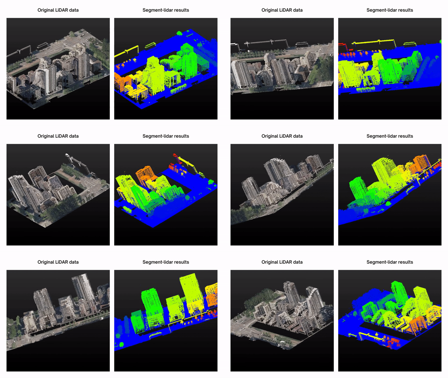
Installation
We recommand using Python>=3.9. First, you need to install PyTorch. Please follow the instructions here.
Then, you can easily install segment-lidar from PyPI:
pip install segment-lidar
Or, you can install it from source by running the following commands:
git clone https://github.com/Yarroudh/segment-lidar
cd segment-lidar
python setup.py install
Please, note that the actual version is always under tests. If you find any issues or bugs, please report them in issues section. The second version should implement more advanced features and fonctionalities.
Documentation
If you are using segment-lidar, we highly recommend that you take the time to read the documentation. The documentation is an essential resource that will help you understand the features of the package, as well as provide guidance on how to use it effectively.
Basic tutorial
A basic tutorial is available here.
You can also refer to API for more information about different parameters.
Without ground filtering
from segment_lidar import samlidar, view

viewpoint = view.TopView()

model = samlidar.SamLidar(ckpt_path="sam_vit_h_4b8939.pth")
points = model.read("pointcloud.las")
labels, *_ = model.segment(points=points, view=view, image_path="raster.tif", labels_path="labeled.tif")
model.write(points=points, segment_ids=labels, save_path="segmented.las")
With ground filtering
from segment_lidar import samlidar, view

viewpoint = view.TopView()

model = samlidar.SamLidar(ckpt_path="sam_vit_h_4b8939.pth")
points = model.read("pointcloud.las")
cloud, non_ground, ground = model.csf(points)
labels, *_ = model.segment(points=cloud, view=view, image_path="raster.tif", labels_path="labeled.tif")
model.write(points=points, non_ground=non_ground, ground=ground, segment_ids=labels, save_path="segmented.las")
Note: The latest version of segment-lidar supports defining a custom pinhole camera, with or without interactive visualization, and save the view as an image. Please, refer to the documentation for more details.
Sample data
For testing purposes, you can download a sample here: pointcloud.las.
This data was retrieved from AHN-4. For more data, please visit GeoTiles.nl.
Model checkpoints
Click the links below to download the checkpoint for the corresponding model type.
vit_h: ViT-H SAM model.vit_l: ViT-L SAM model.vit_b: ViT-B SAM model.
Docker Image
segment-lidar is also available as Docker image.
These are the steps to run segment-lidar as a Docker container:
- First pull the image using the
docker pullcommand:
docker pull yarroudh/segment-lidar
- To run the Docker container and mount your data and script file inside it, use the
docker runcommand with the-voption to specify the path to the host directory and the path to the container directory where you want to mount the data folder. For example:
docker run -d -v ABSOLUTE_PATH_TO_HOST_DATA:/home/user yarroudh/segment-lidar
This command will start a Docker container in detached mode, mount the ABSOLUTE_PATH_TO_HOST_DATA directory on the host machine to the /home/user/data directory inside the container, and run the yarroudh/segment-lidar image. Do not change the path of the directory inside the container.
- Find the container ID and copy it. You can use the
docker pscommand to list all running containers and their IDs. - Launch a command inside the container using
docker exec, use the container ID or name and the command you want to run. For example:
docker exec CONTAINER_ID python SCRIPT_FILE
- To copy the output of the command from the container to a local path, use the
docker cpcommand with the container ID or name, the path to the file inside the container, and the path to the destination on the host machine. For example:
docker cp CONTAINER_ID:/home/user/PATH_TO_OUTPUT PATH_ON_HOST_MACHINE
- Finally, after executing all the commands and copying the results to your local machine, you can stop the Docker container using the
docker stopcommand followed by the container ID or name:
docker stop CONTAINER_ID
Related repositories
We would like to express our acknowledgments to the creators of:
Please, visit these repositories for more information about image raster automatic segmentation using SAM from Meta AI.
License
This software is under the BSD 3-Clause "New" or "Revised" license which is a permissive license that allows you almost unlimited freedom with the software so long as you include the BSD copyright and license notice in it. Please refer to the LICENSE file for more detailed information.
Citation
The use of open-source software repositories has become increasingly prevalent in scientific research. If you use this repository for your research, please make sure to cite it appropriately in your work. The recommended citation format for this repository is provided in the accompanying BibTeX citation. Additionally, please make sure to comply with any licensing terms and conditions associated with the use of this repository.
@misc{yarroudh:2023:samlidar,
  author = {Yarroudh, Anass},
  title = {LiDAR Automatic Unsupervised Segmentation using Segment-Anything Model (SAM) from Meta AI},
  year = {2023},
  howpublished = {GitHub Repository},
  url = {https://github.com/Yarroudh/segment-lidar}
}
Yarroudh, A. (2023). LiDAR Automatic Unsupervised Segmentation using Segment-Anything Model (SAM) from Meta AI [GitHub repository]. Retrieved from https://github.com/Yarroudh/segment-lidar
Author
This software was developped by Anass Yarroudh, a Research Engineer in the Geomatics Unit of the University of Liege. For more detailed information please contact us via ayarroudh@uliege.be, we are pleased to send you the necessary information.
Copyright © 2023, Geomatics Unit of ULiège. Released under BSD-3 Clause License.
1 maintainer

Metadata
1 maintainer
Release files for segment-lidar 0.2.1
For a detailed explanation of source distributions (sdists) and built distributions (wheels), please see the package formats documentation.
Source distribution (sdist)
| File | Size | Uploaded | |
|---|---|---|---|
| segment-lidar-0.2.1.tar.gz | 16.5 kB | Details |
Built distribution (wheel)
| File | Interpreter | ABI | Platform | Reset |
|---|---|---|---|---|
| segment_lidar-0.2.1-py3-none-any.whl | Python 3 | none | any | Details |
Total release size: 30.6 kB
Release files / segment-lidar-0.2.1.tar.gz
| Download URL | segment-lidar-0.2.1.tar.gz |
|---|---|
| Size | 16.5 kB |
| Tags | Source |
|
SHA-256 checksum How to use checksums |
181a35daa802fe2976a53932ad9122b766c2ea91f1bd771d93e3b03b7b6d7b42
|
|
BLAKE2b-256 checksum How to use checksums |
06c0e374af09ec0ec739f8e47eb9e8c4e845dc541426be226efc3f41307f3bb5
|
| Upload date | |
|
Uploaded using Trusted Publishing? What is trusted publishing? |
No |
| Uploaded via |
twine/4.0.2 CPython/3.9.18
|
Release files / segment_lidar-0.2.1-py3-none-any.whl
| Download URL | segment_lidar-0.2.1-py3-none-any.whl |
|---|---|
| Size | 14.1 kB |
| Tags | Python 3 |
|
SHA-256 checksum How to use checksums |
900d8d727b7359e36f17890039590507252c2ba63361f2b00a1018e1ee942439
|
|
BLAKE2b-256 checksum How to use checksums |
a131be7e704e77e98410f0abcbccef71ffc6493c8843da3d6920a480b65600b0
|
| Upload date | |
|
Uploaded using Trusted Publishing? What is trusted publishing? |
No |
| Uploaded via |
twine/4.0.2 CPython/3.9.18
|














