
A python library to generate and interact with flatmaps in a jupyter notebook using the ipyleaflet library.


Project description

SPARClet
A python library to generate and interact with flatmaps in a jupyter notebook using the ipyleaflet library.
Project Goals
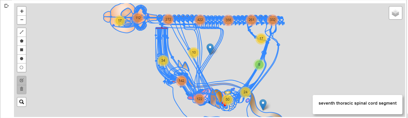
SPARC has created detailed maps of the PNS, stored as flatmaps. However, the current interactivity possible with these flatmaps is basic and non-extensible. We use here ipyleaflet, a popular javascript library for adding interactive features to geographical maps to display and intergrate flatmaps in Jupyter notebooks, popular for their use in scientific data analysis and computing. Using this, we hope to allow researchers much greater and extensible interactivity with SPARC flatmaps in an easy to use manner. These additonal fucntionalities could help a researcher agument the research process and help in developing a deeper understanding of theor field of study. To allow for easier use by other, we also built a new python library called Sparclet.
Solution
We created Sparclet, a pypi application that allows flatmaps to be viewed in Jupyter Notebook and be interacted in novel ways using the ipyleaflet library to help facilitate an individualized research process. We went about this using the following solutions.
- Simplified the process of retrieving flatmaps from their APIs by building a python routine that requires a user to only provide the model number of a species or a model to generate the maps locally.
- Added functions pertaining to adding markers and annotations that could be stored as study-specific file on a server.
- Added multiple functionalities such as layer control, hovering annotations, custom drawing tools, heatmaps and antpaths for interacting with the flatmaps
- We also attempted to provide additonal fucntionalities such as comparing cross species maps with a splitmap feature with respect to specific anatomical regions. A search bar that could be used for navigating annotations and obtain methods used in relevant studies.
- Created a new open source python library that coule be used by the SPARC community in the future. The additional fucntionalities mentioned above will be the subjects of open source contributions to our library.
Functions
Listed below are functions that can be called in regard to their class
Build_map class
Build_map class wraps the access to flatmap server and consequent construction of ipyleaflet map object. It asks the server for the set of flatmaps it currently has access to, from which the user can select one using a numerical tag. In the future, we hope to provide a more human-friendly access to individual maps.
__init__: this is the function that calls the class itself. the parameters it takes in are the server url and the tag. The tag is the index in the list of image layers in the server. To determine the tag you will have to use a GET request like below

 import requests
 req = requests.get(server_url)
 url_dict = req.json()
 print(url_dict)

  then see where the desired flatmap falls in the dictionary, the index is the tag (remeber index starts at 0)

get_url_dict: retrieves the Accept header, giving details on max zoom, min zoom, and bounds

get_model_id: retrieves the unique id attached to the flatmap, used in the url

get_model_name: retrieves the identifiable name for the flatmap

get_model_layer_url: creates the url that is linked to the location of the layer in the server

get_model_image_layer: retrieves image that make up the flatmap

get_tile_urls: creates and returns tile urls that make up the map used in ipyleaflet

get_annotations: retrieves annotation data that correlates with the flatmap features

split_map: puts two maps side by side for analysis

build_map_without_markers: creates the general flatmap with out feature markers
leaflet_addons class
leaflet_addons wraps the interactive features added by ipyleaflet, which can be extended by extending this class. Users can select which interactive features they want to have on the current flatmap.
add_markers: adds markers to the location of the annotation feature

hover: allows the user to hover over the flatmap and get real time feedback

update_html: updates the widget at bottom right with label of the current object being hovered on
CustomWTKLayer class
A custom version of WKTLayer in ipyleaflet, used for hover.
_get_data1: stores annotaion data in self.data
Sparclet python package
We welcome open source contributions to our library. There a many more functionalities that can be added to the flatmaps and we were restricted by the duration of the codeathon. We will be maintaining this library and making it more beneficial to the SPARC community.
Team Members
Archit Bhatnagar -Max Planck Institute of Molecular Cell Biology and Genetics, Dresden
Chloe Hoff -Undergrad at the University of Vermont
Koustubh Sudarshan -Dalhousie University, Canada & UCLA Cardiac Arrhythmia Center, USA .
Example Code:
from sparclet.main import *
# Whole rat flatmap
map1 = Build_Map('https://mapcore-demo.org/current/flatmap/v2', 2)
# Build given map
built_map = map1.build_map_without_markers()
# Leaflet addons
leaf = leaflet_addons(map1, built_map)
# Example addon: Hover over map to see label names
leaf.hover()
# Display map
built_map
Release history Release notifications | RSS feed


Download files
Download the file for your platform. If you're not sure which to choose, learn more about installing packages.
Source Distribution
Built Distribution
Filter files by name, interpreter, ABI, and platform.
If you're not sure about the file name format, learn more about wheel file names.
Copy a direct link to the current filters
File details
Details for the file sparclet-1.0.1.tar.gz.
File metadata
- Download URL: sparclet-1.0.1.tar.gz
- Upload date:
- Size: 11.3 kB
- Tags: Source
- Uploaded using Trusted Publishing? No
- Uploaded via: twine/4.0.1 CPython/3.9.13
File hashes
| Algorithm | Hash digest | |
|---|---|---|
| SHA256 |
f2c9a2006f6d7ba89eb56a00b3a580da8f8fe8e6c5097dd2ea29f62e7c28776b
|
|
| MD5 |
fbbff757e9078535a65f4c276d9c3a80
|
|
| BLAKE2b-256 |
cfb12a0d415ce5e2919b9ee013999d1baf6e84d53a891da59fdd2de0e2f284ee
|
File details
Details for the file sparclet-1.0.1-py3-none-any.whl.
File metadata
- Download URL: sparclet-1.0.1-py3-none-any.whl
- Upload date:
- Size: 9.5 kB
- Tags: Python 3
- Uploaded using Trusted Publishing? No
- Uploaded via: twine/4.0.1 CPython/3.9.13
File hashes
| Algorithm | Hash digest | |
|---|---|---|
| SHA256 |
f93be3b19398b998fc24354b2d65740affbad3f4116bf718ca16ed11a528062f
|
|
| MD5 |
f0fafb580d15d0dbdea54559a4716baf
|
|
| BLAKE2b-256 |
719e77d3225dfd55fa06c020d06a0277433f4c6a6279b60556d3ba9440452618
|






