
track2corridor-geo




Build an auditable centerline and corridor from ground mobile laser-scanning (MLS) trajectory points.
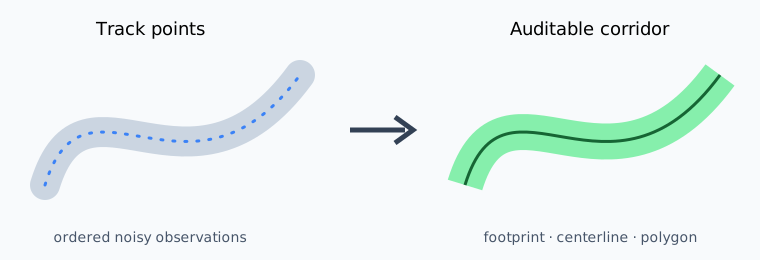
Here, a noisy track means ordered trajectory coordinates with positional
scatter, short side deviations, or gaps around the route actually travelled. It
does not mean the complete laser point cloud. track2corridor converts those
ordered trajectory points into a buffered footprint, raster
skeleton, NetworkX graph, centerline, and fixed-width corridor. It exposes every
intermediate geometry and a diagnostics report instead of hiding algorithmic
warnings behind a single polygon.
Quick start
python -m pip install track2corridor-geo
track2corridor build track.laz \
  --footprint-width 20 \
  --corridor-width 8 \
  --output corridor.gpkg
CSV input must contain x,y columns and needs an explicit projected CRS:
track2corridor build track.csv --crs EPSG:32637 --output corridor.gpkg
Reproducible example
Generate and process three deterministic trajectory scenarios plus equivalent CSV, LAZ, and GeoPackage inputs:
python examples/run_examples.py
| scenario | purpose | expected diagnostic |
|---|---|---|
mls-s-track |
positional scatter around a smooth MLS trajectory | one connected graph component |
disconnected |
a gap wider than the point footprint | two graph components and centerline parts |
short-spur |
a short side deviation from the main route | branch-pruning behavior is recorded |
format-track |
identical ordered points in CSV, LAZ, and GeoPackage | all readers return the same coordinates |
Generated inputs, outputs, and diagnostics are placed under
examples/generated/. To run the standard case through the CLI:
track2corridor build examples/generated/mls-s-track.csv \
  --crs EPSG:32637 \
  --time-field sequence \
  --footprint-width 14 \
  --corridor-width 6 \
  --cell-size 1 \
  --min-branch-length 4 \
  --output examples/generated/mls-s-track-cli.gpkg \
  --diagnostics examples/generated/mls-s-track-cli.json
The GeoPackage contains three inspectable layers:
| layer | meaning |
|---|---|
footprint |
union of point buffers used as raster input |
centerline |
graph edges converted back to line geometry |
corridor |
fixed-width buffer around the derived centerline |
The JSON report records input point count, raster dimensions and cell count, skeleton pixels, graph nodes and edges, connected components, pruned nodes, extended endpoints, and centerline part count.
Parameters
| option | default | effect |
|---|---|---|
--footprint-width |
20 m | width of the buffered point footprint |
--corridor-width |
8 m | final corridor width |
--cell-size |
footprint / 16 | raster resolution; smaller is slower |
--min-branch-length |
10 m | removes shorter leaf branches |
--extend-endpoints |
0 m | extends graph leaves before buffering |
--max-cells |
10,000,000 | rejects unexpectedly large rasters |
Python API
from track2corridor import CorridorOptions, CorridorResult, build_corridor

result: CorridorResult = build_corridor(
    points,
    "EPSG:32637",
    CorridorOptions(footprint_width=14, corridor_width=6, cell_size=1),
)
print(result.diagnostics.to_dict())
Input behavior
- LAS/LAZ uses
gps_timefor stable ordering when that dimension exists. - CSV uses source order unless
--time-fieldis supplied. - Other vector formats must contain only Point geometries and retain their CRS.
- An explicit
--crsmust match embedded CRS metadata; reprojection is never performed automatically.
Limits
- Coordinates must use a projected CRS with horizontal units in metres.
- The method derives a skeleton from point buffers; it is not a map-matching or trajectory-inference algorithm.
- Disconnected point clusters produce multiple centerline components.
- Dense data, a very small cell size, or a very large extent can create expensive
rasters;
--max-cellsprovides a hard safety limit. - Results should be visually reviewed when the footprint contains loops, wide junctions, or sparse gaps.
Run track2corridor --help for all options. Exit code 0 means success and 2
means invalid input or a processing failure.
The pre-release and launch checks are listed in
docs/release-checklist.md.
Development
python -m pip install -e ".[test]"
python -m ruff check .
python -m ruff format --check .
python -m pytest
Copyright 2026 Alena Nikitina. Licensed under the Apache License 2.0.
1 maintainer

Metadata
1 maintainer
Release files for track2corridor-geo 0.1.1
For a detailed explanation of source distributions (sdists) and built distributions (wheels), please see the package formats documentation.
Source distribution (sdist)
| File | Size | Uploaded | |
|---|---|---|---|
| track2corridor_geo-0.1.1.tar.gz | 19.8 kB | Details |
Built distribution (wheel)
| File | Interpreter | ABI | Platform | Reset |
|---|---|---|---|---|
| track2corridor_geo-0.1.1-py3-none-any.whl | Python 3 | none | any | Details |
Total release size: 33.3 kB
Release files / track2corridor_geo-0.1.1.tar.gz
| Download URL | track2corridor_geo-0.1.1.tar.gz |
|---|---|
| Size | 19.8 kB |
| Tags | Source |
|
SHA-256 checksum How to use checksums |
5df32bdd70e18b733e0a0596da6f555465b86232aec2b92a6808ecdfa44bda3f
|
|
BLAKE2b-256 checksum How to use checksums |
c9a36c0ce66188897d3726d8d3640d278945ceb04e3fe7963c5a343a63f7a41b
|
| Upload date | |
|
Uploaded using Trusted Publishing? What is trusted publishing? |
Yes |
| Uploaded via |
twine/7.0.0 CPython/3.13.14
|
Provenance
Provenance describes where a file came from. On PyPI, provenance is shared via attestations, which provide a verifiable record of the build or publishing details. View details, limitations and caveats.


PyPI Publish Attestation
PyPI verified that this artifact, at this checksum, originated from the publisher listed below.
Signed by GitHub Actions, verified by PyPI on Oct 1, 2026.
Transparency logRelease files / track2corridor_geo-0.1.1-py3-none-any.whl
| Download URL | track2corridor_geo-0.1.1-py3-none-any.whl |
|---|---|
| Size | 13.5 kB |
| Tags | Python 3 |
|
SHA-256 checksum How to use checksums |
fefd481c13d3e03f45fe134d750e41bf7c727359ce81b8bafd09d583bc54ba8b
|
|
BLAKE2b-256 checksum How to use checksums |
898b83494369384f7ff709bb82cd14a580e5157bf59c432b2d054d626d6e0afd
|
| Upload date | |
|
Uploaded using Trusted Publishing? What is trusted publishing? |
Yes |
| Uploaded via |
twine/7.0.0 CPython/3.13.14
|
Provenance
Provenance describes where a file came from. On PyPI, provenance is shared via attestations, which provide a verifiable record of the build or publishing details. View details, limitations and caveats.
PyPI Publish Attestation
PyPI verified that this artifact, at this checksum, originated from the publisher listed below.
Signed by GitHub Actions, verified by PyPI on Oct 1, 2026.
Transparency log












