
UrbanMARL: Vectorized Urban Multi-Agent Reinforcement Learning





UrbanMARL is a high-performance, GPU-vectorized, data-driven multi-agent reinforcement learning (MARL) framework and digital twin simulator tailored for 6G geospatial radio environments, Unmanned Aerial Vehicles (UAVs), Mobile Edge Computing (MEC) networks, and other emerging applications.
UrbanMARL is built natively on TorchRL, PyTorch, TensorDict, and BenchMARL, vectorizes 3D spatial ray-casting of Line-of-Sight (LoS) paths, ITU-R P.1410 urban map procedural generation, mmWave radio propagation, and M/M/c queuing dynamics across hundreds of concurrent environments.
UrbanMARL is developed to extend the PhD research project titled "Three-Dimensional Mobility for Multi-UAV Assisted Multi-Access Edge Computing" conducted by Dr. Basheer Raddwan under the supervision of Prof. Ibrahim Al-Baltah, at the Department of Information Technology, Faculty of Computer and Information Technology, Sana’a University, Yemen, by refactoring the Panda5gSim project into a fully vectorized, data-driven, GPU-accelerated, and TorchRL-compatible MARL framework.
🎥 Video Overview
Rendering example of 3D and 2D geospatial and building heatmap during training of 6 MARL algorithms with 3 task scenarios; using 3 UAV-BS and 10 UE. Orange lines show UAV trajectories, green and red lines show LoS/NLoS conditions.
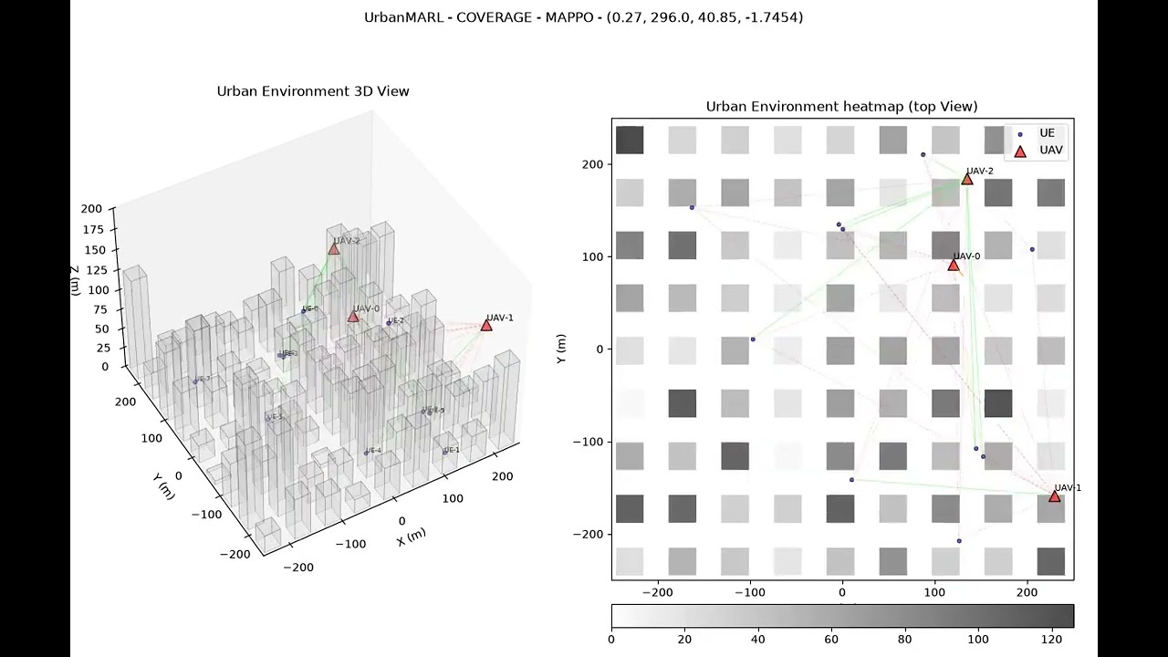
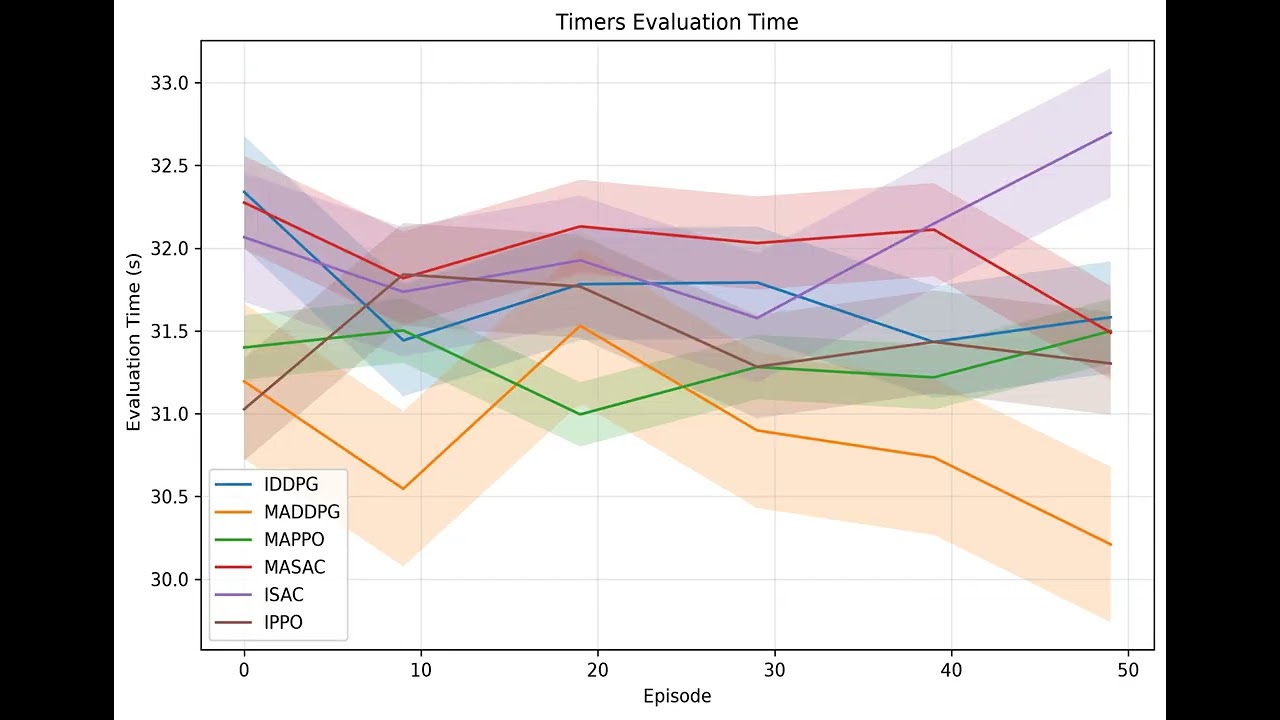
Example of analysis and result evaluation images rendered in a single video.
💡 Key Features
- ⚡ 100% Vectorized PyTorch Core: Batched 3D spatial movement, line-of-sight (LoS) calculations, building collision detection, radio propagation, and queuing systems run natively on GPU/CPU without python-loop bottlenecks.
- 🏢 ITU-R P.1410 3D Procedural Urban Maps: Realistic 3D urban environments parameterized by building coverage ($\alpha$), building density ($\beta$), height distribution ($\gamma$), street width, and building dimensions using Poisson Point Processes.
- 📡 Vectorized mmWave Radio Channel Model: Computes Friis path loss, LoS/NLoS attenuation exponent shifts, Signal-to-Interference-plus-Noise Ratio (SINR), and Shannon channel capacity for 29 GHz / 6G networks.
- 🖥️ Vectorized M/M/c MEC Queue Model: Pure PyTorch tensor implementation of M/M/c queuing theory calculating server utilization, average queue lengths, waiting times, and total response delay.
- 🤖 BenchMARL & TorchRL Native: Fully compatible with BenchMARL task APIs (
UrbanEnvTask). Supports SOTA MARL algorithms (MAPPO, MADDPG, MASAC, IPPO, IDDPG, ISAC, QMIX). - 🎬 3D Rendering & Analytics Suite: Includes interactive Matplotlib/MP4 3D trajectory rendering, CSV/TensorBoard logging, and evaluation plotters.
🎮 Scenarios Overview
| Scenario Name | Description | Agent Action Space | Observation Space |
|---|---|---|---|
uav_navigation |
Multi-UAV assest 5G+/6G wireless network independently/cooperatively learn to improve the coverage by navigating the simulation volume to find the best positions. | Continuous velocity $(v_h, \phi, v_z)$ | UAV Position $(x,y,z)$ & Battery level |
uav_ue_los |
Multi-UAV assest 5G+/6G wireless network independently/cooperatively learn to maximize the Line-of-sight status with ground IoTs/users for high-altitude platform stations and UAV relays. | Continuous velocity $(v_h, \phi, v_z)$ | UAV Position $(x,y,z)$ & Battery level |
coverage |
Multi-UAV assest 5G+/6G wireless network independently/cooperatively learn to maximize the spatial coverage. | Continuous velocity $(v_h, \phi, v_z)$ | UAV Position $(x,y,z)$ & Battery level |
⚙️ Installation
Prerequisites
- Python: $\ge 3.10$ tested on 3.12
- PyTorch: $\ge 2.12.0$ (CUDA recommended for large batch sizes)
Setup Steps
-
Clone the repository:
git clone https://github.com/yemenlinux/vUrbanMARL.git
cd vUrbanMARL
-
Create a virtual environment (optional but recommended):
Using conda:
    conda create -n vurbanmarl python=3.12
    conda activate vurbanmarl
Using standard Python venv:
python3 -m venv venv
source venv/bin/activate
-
Install dependencies and the package:
For CPU-only installation:
pip install -r requirements/cpu.txt
For GPU installation (CUDA 12.6 - recommended for old GPUs):
pip install -r requirements/cuda126.txt
For GPU installation (CUDA 13.0 - recommended for new GPUs):
pip install -r requirements/cuda130.txt
🚀 Quick Start
1. Direct PyTorch / TorchRL Usage
You can instantiate and step through UrbanEnv directly using TorchRL semantics:
import torch
from urbanmarl.envs.base_env import UrbanEnv

# Initialize environment with 64 parallel batched environments on GPU/CPU
env = UrbanEnv(
    num_envs=64,
    scenario="uav_navigation",
    num_uavs=3,
    num_ues=50,
    device="cuda" if torch.cuda.is_available() else "cpu",
)

# Reset environment
tensordict = env.reset()
print("Initial Observation:", tensordict["agents", "observation"].shape)

# Sample action and step
actions = env.action_spec.sample()
tensordict.update(actions)
next_tensordict = env.step(tensordict)

print("Reward:", next_tensordict["next", "agents", "reward"].shape)
print("Done:", next_tensordict["next", "done"].shape)
2. Running MARL Benchmarks via BenchMARL
Run comparative benchmark training across multiple MARL algorithms (e.g., MAPPO, MADDPG):
python scripts/run_benchmark.py
Or execute full benchmark experiments with automated result collection and plotting:
python scripts/full_experiment.py
📊 Evaluation & Visualization
- Interactive Notebooks: Explore evaluate.ipynb and test_renderer.ipynb for plotting scalar metrics and rendering 3D UAV trajectories over procedurally generated building maps.
- Result Processing: Utilities in urbanmarl/eval_results.py format CSV/TensorBoard outputs into publication-ready figures.
📄 License
This project is released under the MIT License.
Affiliation and Sponsors
Department of Information Technology, Faculty of Computer and Information Technology, Sana’a University, Yemen.
✍️ Authors & Citation
Created by: Dr. Basheer Raddwan
Supervised by: Prof. Ibrahim Al-Baltah
If you use UrbanMARL in your research, please cite:
@inproceedings{raddwan_urbanmarl_2026,
	title = {{UrbanMARL}: {A} {Vectorized} {Urban} {Simulator} for {Multi}-{Agent} {Reinforcement} {Learning}},
	url = {https://www.researchgate.net/doi/10.13140/RG.2.2.17864.69122},
	doi = {10.13140/RG.2.2.17864.69122},
	urldate = {2026-07-31},
	author = {Raddwan, Basheer and Al-Baltah, Ibrahim and Zahary, Ammar and Alshamery, Anwar},
	year = {2026},
}
Related work
@article{RADDWAN2025104019,
title = {Quantify the joint effect of mobility and urban environment on computation offloading to multi-UAV MEC network: Sojourn time},
journal = {Ad Hoc Networks},
volume = {179},
pages = {104019},
year = {2025},
issn = {1570-8705},
doi = {https://doi.org/10.1016/j.adhoc.2025.104019},
url = {https://www.sciencedirect.com/science/article/pii/S1570870525002677},
author = {Raddwan, Basheer and Al-Baltah, Ibrahim}
}

@ARTICLE{11050367,
  author={Raddwan, Basheer and Al-Baltah, Ibrahim},
  journal={IEEE Access},
  title={Mobility-Aware Bivariate Line-of-Sight Probability for Air-to-Ground Communications Using Millimeter and Terahertz Waves},
  year={2025},
  volume={13},
  number={},
  pages={123913-123930},
  keywords={Air to ground communication;Atmospheric modeling;Layout;Geometry;Line-of-sight propagation;Directional antennas;Ray tracing;Communication channels;Buildings;ITU;Line-of-sight probability;mobility;air-to-ground communication;multi-access edge computing;ray-tracing;unmanned aerial vehicles;service time;sojourn time;urban;simulation},
  doi={10.1109/ACCESS.2025.3582890}}

@INPROCEEDINGS{10777167,
  author={Raddwan, Basheer and Al-Baltah, Ibrahim and Ghaleb, Mukhtar},
  booktitle={2024 1st International Conference on Emerging Technologies for Dependable Internet of Things (ICETI)},
  title={Environment-Aware 3D Mobility Simulation for the 5G and 6G Wireless Networks},
  year={2024},
  volume={},
  number={},
  pages={1-8},
  keywords={Three-dimensional displays;Mobility models;Biological system modeling;Wireless networks;Urban areas;Interference;Ray tracing;Throughput;3GPP;Signal to noise ratio;urban;5G;6G;mobility;ray-tracing;simulation;open-source;handover rate;framework;multi-access edge computing;unmanned aerial vehicle;3D mobility;3D environment},
  doi={10.1109/ICETI63946.2024.10777167}}
Contributors:
- Dr. Basheer Raddwan
- Prof. Ibrahim Al-Baltah
1 maintainer

Download files
Download the file for your platform. If you're not sure which to choose, learn more about installing packages.
Source Distribution
Built Distribution
Filter files by name, interpreter, ABI, and platform.
If you're not sure about the file name format, learn more about wheel file names.
Copy a direct link to the current filters
File details
Details for the file urbanmarl-0.1.0.tar.gz.
File metadata
- Download URL: urbanmarl-0.1.0.tar.gz
- Upload date:
- Size: 978.1 kB
- Tags: Source
- Uploaded using Trusted Publishing? No
- Uploaded via:
twine/7.0.0 CPython/3.12.13
File hashes
| Algorithm | Hash digest | |
|---|---|---|
| SHA256 |
ca73becd59030b3af4c1a3f261597070921c5c05b51841f17a24f8711bd283ac
|
|
| MD5 |
f09336fc9171e833b3e182cb53672a9e
|
|
| BLAKE2b-256 |
431ef949cdf1227ec29150027426395cbc49367b3db975215066f15b82dbd27e
|
File details
Details for the file urbanmarl-0.1.0-py3-none-any.whl.
File metadata
- Download URL: urbanmarl-0.1.0-py3-none-any.whl
- Upload date:
- Size: 50.7 kB
- Tags: Python 3
- Uploaded using Trusted Publishing? No
- Uploaded via:
twine/7.0.0 CPython/3.12.13
File hashes
| Algorithm | Hash digest | |
|---|---|---|
| SHA256 |
2864e25b0ee8ca37b482b5a8934cfb1d32b7c8694d9a998635eb23ca2a3a1aa4
|
|
| MD5 |
fb101b6c1766d51bd5a3ea29f68a965c
|
|
| BLAKE2b-256 |
780f482c22d1d1bf0e946c6a8b24ba910c618f5bb998180686a246081fe4a045
|














