Versatile Modeling of Deformation
Verified details
These details have been verified by PyPIProject links
GitHub Statistics
Maintainers


Project description

Versatile Modeling Of Deformation


Authors: Mario Angarita, Ronni Grapenthin, Scott Henderson, Michael Christoffersen and Kyle Anderson
What is VMOD?
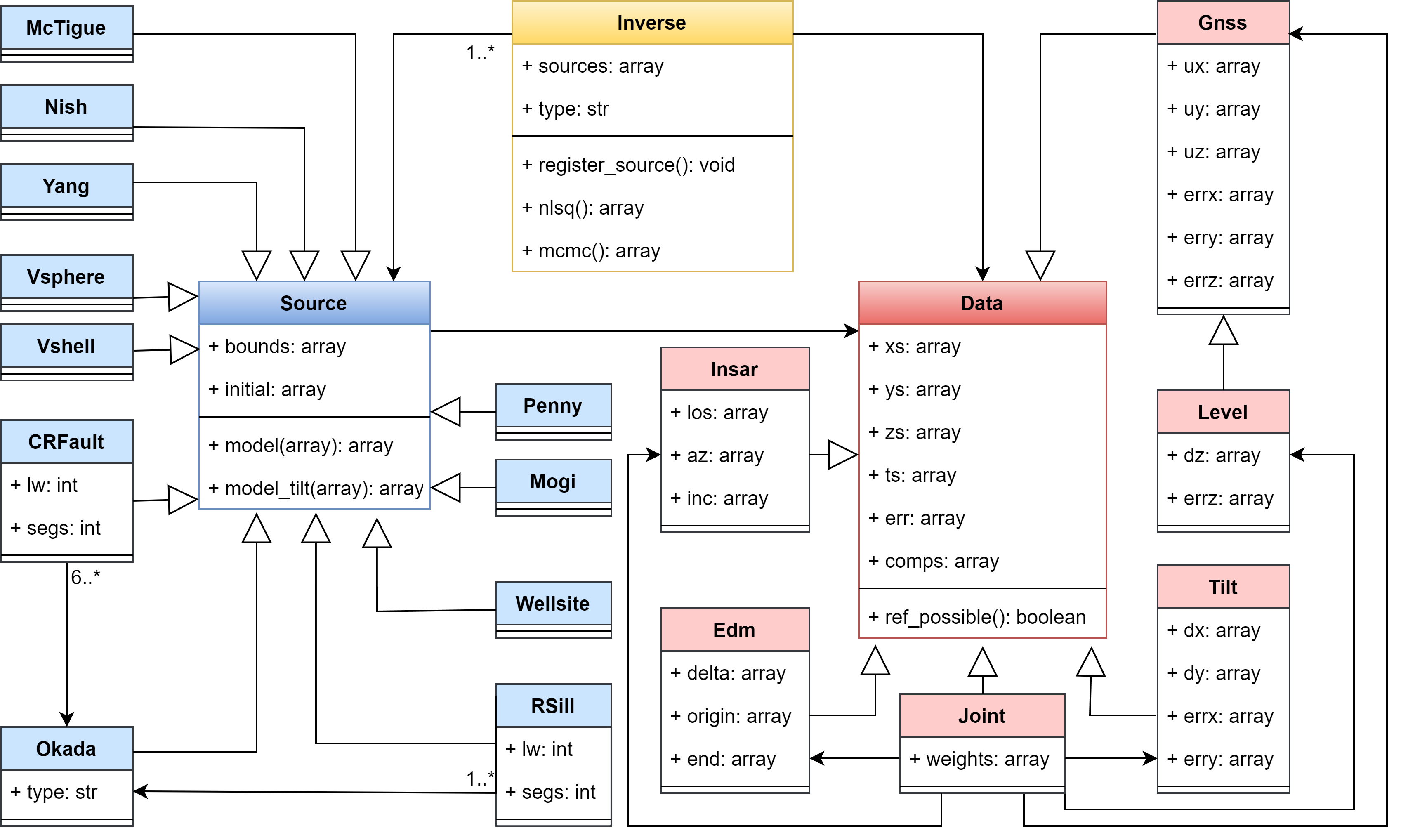
VMOD is a python-based object oriented framework. Its main purpose is to model multiple types of geodetic data including:
- GNSS
- InSAR
- Level
- EDM
- Tilt
These observations can be interpreted with one or more analytical models that represent pressurized sources such as:
- Pressurized sphere in elastic medium
- Pressurized sphere in viscoelastic medium
- Pressurized sphere in a viscoelastic shell in elastic medium
- Pressurized prolate spheroid in elastic medium
- Dislocation (Fault/Sill) in elastic medium
- Penny shaped crack in elastic medium
- Point source in elastic medium
- Wellsite in porelastic medium
- Ring fault in elastic medium
- Regularized fault/sill in elastic medium
- Open conduit in elastic medium
The framework offers two different inversion techniques to solve for the source parameters:
- Non-linear least squares
- Bayesian approach
The inversions can include one or multiple data types in the inversion and the model can be composed by multiple sources. The user can customize or inherit current models to create complexer geometries.
Standard Installation
We recommend using Anaconda or Miniconda to create an environment in which to install VMOD to prevent dependency conflicts.
conda env create --file=environment.yml
conda activate vmod
python -m jupyterlab
Then run one of the notebooks.
Run an inversion:
In this repository we included several notebooks to show the steps necessary to run an inversion using GNSS, InSAR, and joint datasets. We also included an example for an InSAR dataset on Unimak Island.
Stress calculations:
VMOD allows to calculate Coulomb stress changes for forward models in the notebook Coulomb stress changes and the magnitude and orientation of principal stresses
Add new datatype:
Users wishing to include a new datatype should clone the source repository and create a new file in the data folder. This file should contain a new class that inherit from the 'Data' class and that has the functions to initialize the attributes, adding the components belonging to the datatype and a function to derive the components from 3d displacements. For example, in the Insar class we defined the following functions:
class Insar(Data):
    def __init__():
        ...
    def add_los(self, los):
        ...
    def from_model3d(self, func):
        ...
Add new model:
Users wishing to include a new model should clone the source repository and create a new file in the source folder. This file should contain a new class that inherit from the 'Source' class and that has a function returning the names of the parameters in your model and a function that gives the implementation of your model and return the 3d displacement. If you want to use this model with data that has a temporal dependency you should include the function 'model_t' that implements a time-dependant model. As an option you can include additional functions that return tilt displacements with the function 'model_tilt' or if it has a temporal dependency 'model_tilt_t'. For example, here we show the required functions in our Mogi model:
class Mogi(Source):
    def set_parnames(self):
        ...
    def model(self, params):
        ...
Publications:
A list of publications where VMOD has been used:
- Grapenthin, R., Cheng, Y., Angarita, M., Tan, D., Meyer, F. J., Fee, D., & Wech, A. (2022). Return from Dormancy: Rapid inflation and seismic unrest driven by transcrustal magma transfer at Mt. Edgecumbe (L’úx Shaa) Volcano, Alaska. Geophysical Research Letters, 49(20), e2022GL099464. https://doi.org/10.1029/2022GL099464
- Grapenthin, R., Kyle, P., Aster, R. C., Angarita, M., Wilson, T., & Chaput, J. (2022). Deformation at the open-vent Erebus volcano, Antarctica, from more than 20 years of GNSS observations. Journal of Volcanology and Geothermal Research, 432, 107703. https://doi.org/10.1016/j.jvolgeores.2022.107703
- Graves, E. J., et al. "InSAR-observed surface deformation in New Mexico’s Permian Basin shows threats and opportunities presented by leaky injection wells." Scientific Reports 13.1 (2023): 17308. https://doi.org/10.1038/s41598-023-42696-9
Project details
Verified details
These details have been verified by PyPIProject links
GitHub Statistics
Maintainers


Download files
Download the file for your platform. If you're not sure which to choose, learn more about installing packages.
Source Distribution
Built Distribution
Filter files by name, interpreter, ABI, and platform.
If you're not sure about the file name format, learn more about wheel file names.
Copy a direct link to the current filters
File details
Details for the file vmod_geodesy-2.0.0.tar.gz.
File metadata
- Download URL: vmod_geodesy-2.0.0.tar.gz
- Upload date:
- Size: 59.9 kB
- Tags: Source
- Uploaded using Trusted Publishing? Yes
- Uploaded via: twine/6.1.0 CPython/3.13.7
File hashes
| Algorithm | Hash digest | |
|---|---|---|
| SHA256 |
e988962371673de31524898769c24b9bc242bde50600f79683ed223908da98d3
|
|
| MD5 |
364520068992f9720bfc14668ce363da
|
|
| BLAKE2b-256 |
c3dda770f2795b6baf79d0754531d1afa2a8fffa1e115f0acb1dc13284479428
|
Provenance
The following attestation bundles were made for vmod_geodesy-2.0.0.tar.gz:
Publisher:
python-publish.yml on uafgeotools/vmod
-
Statement:
-
Statement type:
https://in-toto.io/Statement/v1 -
Predicate type:
https://docs.pypi.org/attestations/publish/v1 -
Subject name:
vmod_geodesy-2.0.0.tar.gz -
Subject digest:
e988962371673de31524898769c24b9bc242bde50600f79683ed223908da98d3 - Sigstore transparency entry: 700132037
- Sigstore integration time:
-
Permalink:
uafgeotools/vmod@4c04a8454f5ecf0ac9eb5bdb02bbdc5a834b42d6 -
Branch / Tag:
refs/tags/v2.0.0 - Owner: https://github.com/uafgeotools
-
Access:
public
-
Token Issuer:
https://token.actions.githubusercontent.com -
Runner Environment:
github-hosted -
Publication workflow:
python-publish.yml@4c04a8454f5ecf0ac9eb5bdb02bbdc5a834b42d6 -
Trigger Event:
release
-
Statement type:
File details
Details for the file vmod_geodesy-2.0.0-py3-none-any.whl.
File metadata
- Download URL: vmod_geodesy-2.0.0-py3-none-any.whl
- Upload date:
- Size: 71.4 kB
- Tags: Python 3
- Uploaded using Trusted Publishing? Yes
- Uploaded via: twine/6.1.0 CPython/3.13.7
File hashes
| Algorithm | Hash digest | |
|---|---|---|
| SHA256 |
c68b7a5d41c73f212920f22e70538eadfd3103b1aa207abc85caf91433b9c5f2
|
|
| MD5 |
61721c899b61d15812191730049890cf
|
|
| BLAKE2b-256 |
4acd67dfe20cc12af3b33bcdaf12001130520ffef625f1472cfbe98e626563fb
|
Provenance
The following attestation bundles were made for vmod_geodesy-2.0.0-py3-none-any.whl:
Publisher:
python-publish.yml on uafgeotools/vmod
-
Statement:
-
Statement type:
https://in-toto.io/Statement/v1 -
Predicate type:
https://docs.pypi.org/attestations/publish/v1 -
Subject name:
vmod_geodesy-2.0.0-py3-none-any.whl -
Subject digest:
c68b7a5d41c73f212920f22e70538eadfd3103b1aa207abc85caf91433b9c5f2 - Sigstore transparency entry: 700132046
- Sigstore integration time:
-
Permalink:
uafgeotools/vmod@4c04a8454f5ecf0ac9eb5bdb02bbdc5a834b42d6 -
Branch / Tag:
refs/tags/v2.0.0 - Owner: https://github.com/uafgeotools
-
Access:
public
-
Token Issuer:
https://token.actions.githubusercontent.com -
Runner Environment:
github-hosted -
Publication workflow:
python-publish.yml@4c04a8454f5ecf0ac9eb5bdb02bbdc5a834b42d6 -
Trigger Event:
release
-
Statement type:


