
OptiDamTool















About
OptiDamTool is a Python package designed for analytics and decision-making in dam management. Conceptualized and released on May 29, 2025, the package offers tools for modeling and analyzing hydrological flow across a network of connected dams.
Leveraging functionalities from the open-source GeoAnalyze package, OptiDamTool provides classes that that assist users in preparing inputs for simulating water erosion and sediment transport, and supports decision-making in dam network deployment aimed at environmental sustainability.
Classes
OptiDamTool.WatemSedem
Provides tools to prepare inputs for the WaTEM/SEDEM model, which simulates soil erosion, sediment transport capacity, and sediment delivery to stream networks at the watershed scale. While this class includes built-in methods for generating most required inputs, it is still recommended to consult the GeoAnalyze documentation for any geospatial operations not covered by its methods.
- Convert Digital Elevation Model (DEM) data into the stream files required for the WaTEM/SEDEM model with the
river routing = 1extension enabled. - Extend input rasters beyond the model region and fills NoData cells with valid values, as WaTEM/SEDEM does not support NoData.
- Perform reprojection, clipping, resolution rescaling, and reclassification of rasters.
- Processe open-source Esri land cover data.
- Generate a land management factor raster from land cover inputs.
- Compute the product of soil erodibility and rainfall erosivity factors.
- Convert raster files to the Idrisi raster format, with the
.rstfile extension. - Generate effective upstream drainage area polygons for selected dam locations within a stream network.
OptiDamTool.Network
Offers methods for establishing hydrological and sedimentation flow connectivity between dams using the stream network.
- Identify connectivity between adjacent upstream and downstream dams.
- Compute the controlled upstream drainage areas for selected dam locations within a stream network.
- Estimate sediment inflow to dams based on controlled upstream drainage areas.
- Simulate storage dynamics of individual dams in a system due to sedimentation, using a mass balance approach.
- Generate updated dam location points and their corresponding controlled drainage polygons when dams become inactive during system-wide storage dynamics simulation.
OptiDamTool.Analysis
Provides methods for analyzing simulation outputs and generating insights.
- Integrate sediment delivery to stream segments.
- Generate stream shapefiles with comprehensive information of each segment's drainage area and sediment input.
- Summarize total sediment dynamics for the model region.
- Assign a Coordinate Reference System and the default
GTiffdriver to output Idrisi raster files from a WaTEM/SEDEM simulation.
OptiDamTool.SystemDesign
Provides methods for optimizing dam systems within a watershed using a multi-objective evolutionary computation framework.
- For a fixed number of dams, it determines optimal locations and storage capacities based on annual sediment inflows along watershed drainage pathways.
- Retrieve detailed simulation results for a selected solution scenario.
OptiDamTool.Visual
Provides methods for visualizing simulation outputs.
-
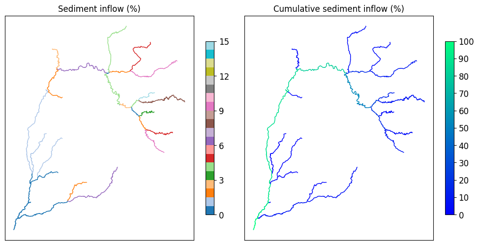
Produces a figure showing sediment inflow percentages to stream segments, relative to the total sediment input across all stream segments.
-
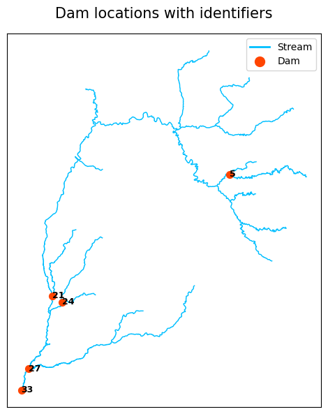
Creates a figure showing dam locations along the stream path.
-
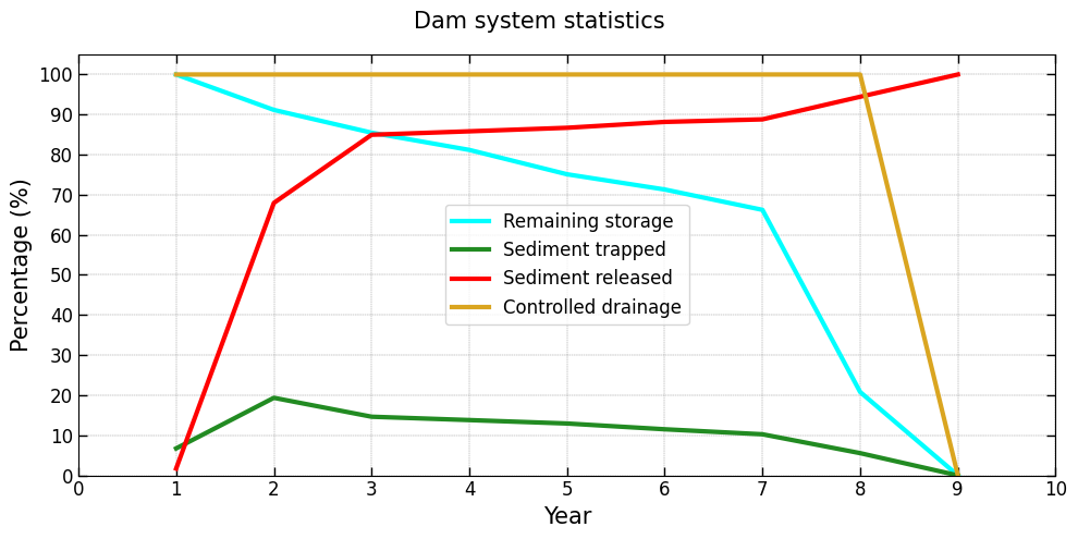
Produces a figure showing dam system-level statistics, including controlled drainage area, remaining storage, sediment trapped, and sediment released.
-
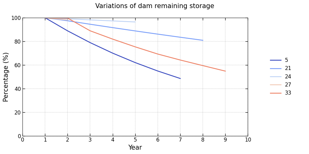
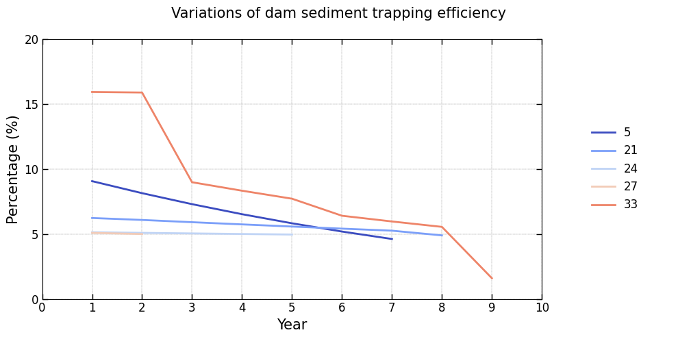
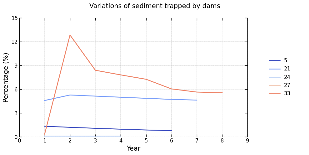
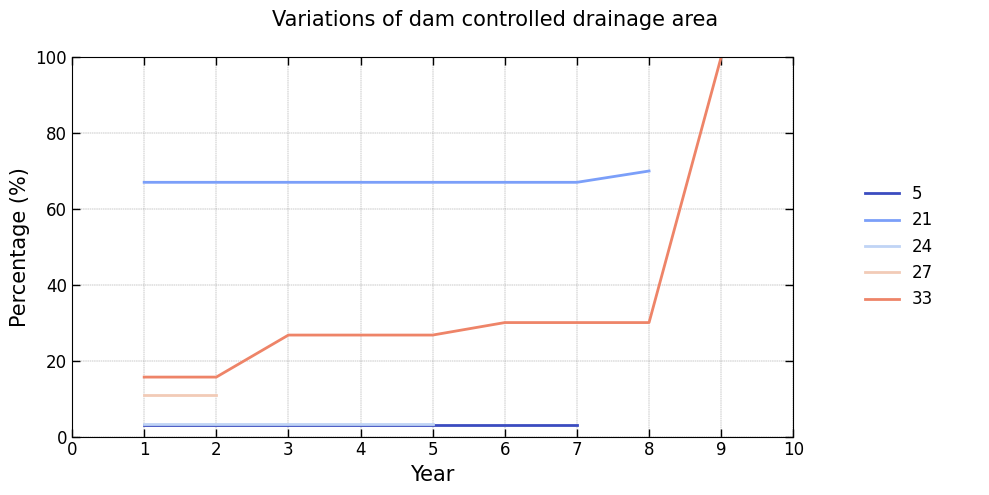
Displays figures illustrating the annual variability of key features for each dam in the system:
Controlled drainage area: Percentage of the drainage area managed by each dam, relative to the total stream drainage area, evaluated at the start of the simulation year.Remaining storage: Percentage of storage capacity remaining relative to the dam’s initial storage, evaluated at the start of the simulation year.Trap efficiency: Efficiency of sediment trapping expressed as a percentage, evaluated at the start of the simulation year.Trapped sediment: Percentage of sediment retained by the dam, relative to the total sediment input across all stream segments, evaluated at the end of the simulation year.
-
Generates Pareto front visualizations to support the analysis of multi-objective optimization results, including parallel coordinate plots and two-dimensional trade-off projections.
The examples below show typical outputs produced by these visualization methods:
Installation
To install, use pip:
pip install OptiDamTool
Quickstart
A brief example of how to start:
import OptiDamTool
watem_sedem = OptiDamTool.WatemSedem()
network = OptiDamTool.Network()
Documentation
For detailed information, see the documentation.
Support
If this project has been helpful and you'd like to contribute to its development, consider sponsoring with a coffee! Support will help maintain, improve, and expand this open-source project, ensuring continued valuable tools for the community.

1 maintainer

Metadata
1 maintainer
Release files for OptiDamTool 0.6.0
For a detailed explanation of source distributions (sdists) and built distributions (wheels), please see the package formats documentation.
Source distribution (sdist)
| File | Size | Uploaded | |
|---|---|---|---|
| optidamtool-0.6.0.tar.gz | 54.2 kB | Details |
Built distribution (wheel)
| File | Interpreter | ABI | Platform | Reset |
|---|---|---|---|---|
| optidamtool-0.6.0-py3-none-any.whl | Python 3 | none | any | Details |
Total release size: 105.1 kB
Release files / optidamtool-0.6.0.tar.gz
| Download URL | optidamtool-0.6.0.tar.gz |
|---|---|
| Size | 54.2 kB |
| Tags | Source |
|
SHA-256 checksum How to use checksums |
f91262a6e90a7b90eb4577cff8035184c893c683fb035f816778a7c9330f11ba
|
|
BLAKE2b-256 checksum How to use checksums |
57bf697ba4bf93c4e04b525da4ae3e7fec84690507df1a96251a47f233035b9b
|
| Upload date | |
|
Uploaded using Trusted Publishing? What is trusted publishing? |
No |
| Uploaded via |
twine/6.2.0 CPython/3.14.4
|
Release files / optidamtool-0.6.0-py3-none-any.whl
| Download URL | optidamtool-0.6.0-py3-none-any.whl |
|---|---|
| Size | 50.9 kB |
| Tags | Python 3 |
|
SHA-256 checksum How to use checksums |
fd1d8dc692f17e4891014fb578694c702351284da160acc4bdf71f0858876685
|
|
BLAKE2b-256 checksum How to use checksums |
78ca4776d9d3e18b79edf93f5cf8ebe693f8eefe6cf3df2ee01495c8ae8eb9fc
|
| Upload date | |
|
Uploaded using Trusted Publishing? What is trusted publishing? |
No |
| Uploaded via |
twine/6.2.0 CPython/3.14.4
|














