Package python pour récupérer les données modélisées de prévision de MétéoFrance

Project description


MeteoFetch permet de récupérer les dernières prévisions modèles MétéoFrance Arome (0.025°, 0.01°, et les cinq domaines Outre-Mer) et Arpege (0.25° et 0.1°) sans clé d'API.
Les prévisions sont renvoyés sous forme de xarray.DataArray. Le package est en cours de développement.
Plus de précisions sur https://meteo.data.gouv.fr.
Installation
pip install meteofetch
Usage
from meteofetch import Arome0025

datasets = Arome0025.get_latest_forecast(paquet='SP3')
datasets['ssr']
Par défaut, meteofetch sert à l'utilisateur toutes les variables contenues dans le paquet requêté.
Il est cependant conseillée de préciser les variables voulues pour limiter l'usage mémoire :
from meteofetch import Arome001

datasets = Arome001.get_latest_forecast(paquet='SP1', variables=('u10', 'v10'))
datasets['u10']

datasets = Arome001.get_latest_forecast(paquet='SP2', variables='sp')
datasets['t']
Vous pouvez ensuite utiliser les méthodes usuelles proposées par xarray pour traiter les DataArray :
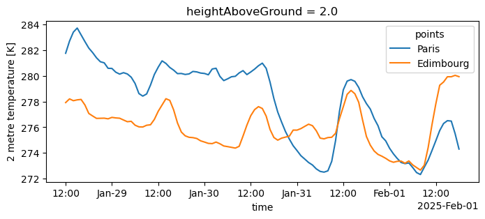
import xarray as xr
import matplotlib.pyplot as plt
from meteofetch import Arpege01

dim = "points"
coords = ["Paris", "Edimbourg"]
x = xr.DataArray([2.33, -3.18], dims=dim)
y = xr.DataArray([48.9, 55.95], dims=dim)

datasets = Arpege01.get_latest_forecast(paquet="SP1", variables="t2m")

plt.figure(figsize=(8, 3))
datasets["t2m"].sel(lon=x, lat=y, method="nearest").assign_coords(
    {dim: coords}
).plot.line(x="time")
Ou encore :
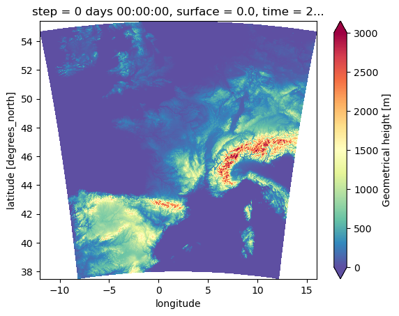
from meteofetch import Arome001

datasets = Arome001.get_latest_forecast(paquet='SP3', variables='h')

datasets['h'].plot(cmap='Spectral_r', vmin=0, vmax=3000)
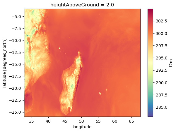
Les domaines Outre-Mer sont également disponibles :
from meteofetch import (
    AromeOutreMerAntilles,
    AromeOutreMerGuyane,
    AromeOutreMerIndien,
    AromeOutreMerNouvelleCaledonie,
    AromeOutreMerPolynesie,
)

datasets = AromeOutreMerIndien.get_latest_forecast(paquet="SP1")
datasets["t2m"].mean(dim="time").plot(cmap="Spectral_r")
Nomenclature
Arpege 0.25° est un modèle couvrant le globe, alors que les trois autres (Arpege 0.1°, Arome 0.025° et Arome 0.01°) sont à aires limitées. Arpege 0.1° couvre l'Europe, tandis que les deux modèles Arome couvrent la France, mais avec des résolutions différentes.
Arome 0.01°
Résumé des champs contenus dans chaque paquet requêtable pour Arome 0.01° :
| Paquet | Champ | Description | Dimensions | Shape d'un run complet |
|---|---|---|---|---|
| SP1 | u10 | 10 metre U wind component | (time, lat, lon) | (52, 1791, 2801) |
| v10 | 10 metre V wind component | (time, lat, lon) | (52, 1791, 2801) | |
| t2m | 2 metre temperature | (time, lat, lon) | (52, 1791, 2801) | |
| r2 | 2 metre relative humidity | (time, lat, lon) | (52, 1791, 2801) | |
| efg10 | 10 metre eastward wind gust since previous post-processing | (time, lat, lon) | (51, 1791, 2801) | |
| nfg10 | 10 metre northward wind gust since previous post-processing | (time, lat, lon) | (51, 1791, 2801) | |
| SP2 | sp | Surface pressure | (time, lat, lon) | (52, 1791, 2801) |
| CAPE_INS | Convective Available Potential Energy instantaneous | (time, lat, lon) | (52, 1791, 2801) | |
| lcc | Low cloud cover | (time, lat, lon) | (51, 1791, 2801) | |
| mcc | Medium cloud cover | (time, lat, lon) | (51, 1791, 2801) | |
| hcc | High cloud cover | (time, lat, lon) | (51, 1791, 2801) | |
| tgrp | Graupel (snow pellets) precipitation | (time, lat, lon) | (51, 1791, 2801) | |
| tirf | Time integral of rain flux | (time, lat, lon) | (51, 1791, 2801) | |
| tsnowp | Total snow precipitation | (time, lat, lon) | (51, 1791, 2801) | |
| SP3 | h | Geometrical height | (lat, lon) | (1791, 2801) |
| HP1 | ws | Wind speed | (time, heightAboveGround, lat, lon) | (52, 2, 1791, 2801) |
| u | U component of wind | (time, heightAboveGround, lat, lon) | (52, 2, 1791, 2801) | |
| v | V component of wind | (time, heightAboveGround, lat, lon) | (52, 2, 1791, 2801) | |
| r | Relative humidity | (time, heightAboveGround, lat, lon) | (52, 4, 1791, 2801) | |
| u10 | 10 metre U wind component | (time, lat, lon) | (52, 1791, 2801) | |
| v10 | 10 metre V wind component | (time, lat, lon) | (52, 1791, 2801) | |
| si10 | 10 metre wind speed | (time, lat, lon) | (52, 1791, 2801) | |
| wdir10 | 10 metre wind direction | (time, lat, lon) | (52, 1791, 2801) | |
| wdir | Wind direction | (time, heightAboveGround, lat, lon) | (52, 3, 1791, 2801) | |
| u100 | 100 metre U wind component | (time, lat, lon) | (52, 1791, 2801) | |
| v100 | 100 metre V wind component | (time, lat, lon) | (52, 1791, 2801) | |
| si100 | 100 metre wind speed | (time, lat, lon) | (52, 1791, 2801) |
Arome 0.025°
Résumé des champs contenus dans chaque paquet requêtable pour Arome 0.025° :
| Paquet | Champ | Description | Dimensions | Shape d'un run complet |
|---|---|---|---|---|
| SP1 | fg10 | Maximum 10 metre wind gust since previous post-processing | (time, lat, lon) | (51, 717, 1121) |
| efg10 | 10 metre eastward wind gust since previous post-processing | (time, lat, lon) | (51, 717, 1121) | |
| nfg10 | 10 metre northward wind gust since previous post-processing | (time, lat, lon) | (51, 717, 1121) | |
| u10 | 10 metre U wind component | (time, lat, lon) | (52, 717, 1121) | |
| v10 | 10 metre V wind component | (time, lat, lon) | (52, 717, 1121) | |
| si10 | 10 metre wind speed | (time, lat, lon) | (52, 717, 1121) | |
| wdir10 | 10 metre wind direction | (time, lat, lon) | (52, 717, 1121) | |
| t2m | 2 metre temperature | (time, lat, lon) | (52, 717, 1121) | |
| r2 | 2 metre relative humidity | (time, lat, lon) | (52, 717, 1121) | |
| prmsl | Pressure reduced to MSL | (time, lat, lon) | (52, 717, 1121) | |
| ssrd | Surface short-wave (solar) radiation downwards | (time, lat, lon) | (51, 717, 1121) | |
| tp | Total Precipitation | (time, lat, lon) | (51, 717, 1121) | |
| tgrp | Graupel (snow pellets) precipitation | (time, lat, lon) | (51, 717, 1121) | |
| tsnowp | Total snow precipitation | (time, lat, lon) | (51, 717, 1121) | |
| SP2 | d2m | 2 metre dewpoint temperature | (time, lat, lon) | (52, 717, 1121) |
| sh2 | 2 metre specific humidity | (time, lat, lon) | (52, 717, 1121) | |
| mx2t | Maximum temperature at 2 metres since previous post-processing | (time, lat, lon) | (51, 717, 1121) | |
| mn2t | Minimum temperature at 2 metres since previous post-processing | (time, lat, lon) | (51, 717, 1121) | |
| t | Temperature | (time, lat, lon) | (52, 717, 1121) | |
| sp | Surface pressure | (time, lat, lon) | (52, 717, 1121) | |
| blh | Boundary layer height | (time, lat, lon) | (52, 717, 1121) | |
| h | Geometrical height | (lat, lon) | (717, 1121) | |
| lcc | Low cloud cover | (time, lat, lon) | (51, 717, 1121) | |
| mcc | Medium cloud cover | (time, lat, lon) | (51, 717, 1121) | |
| hcc | High cloud cover | (time, lat, lon) | (51, 717, 1121) | |
| tirf | Time integral of rain flux | (time, lat, lon) | (51, 717, 1121) | |
| CAPE_INS | Convective Available Potential Energy instantaneous | (time, lat, lon) | (52, 717, 1121) | |
| SP3 | sshf | Time-integrated surface sensible heat net flux | (time, lat, lon) | (51, 717, 1121) |
| slhf | Time-integrated surface latent heat net flux | (time, lat, lon) | (51, 717, 1121) | |
| strd | Surface long-wave (thermal) radiation downwards | (time, lat, lon) | (51, 717, 1121) | |
| ssr | Surface net short-wave (solar) radiation | (time, lat, lon) | (51, 717, 1121) | |
| str | Surface net long-wave (thermal) radiation | (time, lat, lon) | (51, 717, 1121) | |
| ssrc | Surface net short-wave (solar) radiation, clear sky | (time, lat, lon) | (51, 717, 1121) | |
| strc | Surface net long-wave (thermal) radiation, clear sky | (time, lat, lon) | (51, 717, 1121) | |
| iews | Instantaneous eastward turbulent surface stress | (time, lat, lon) | (51, 717, 1121) | |
| inss | Instantaneous northward turbulent surface stress | (time, lat, lon) | (51, 717, 1121) | |
| IP1 | z | Geopotential | (time, isobaricInhPa, lat, lon) | (52, 24, 717, 1121) |
| t | Temperature | (time, isobaricInhPa, lat, lon) | (52, 24, 717, 1121) | |
| u | U component of wind | (time, isobaricInhPa, lat, lon) | (52, 24, 717, 1121) | |
| v | V component of wind | (time, isobaricInhPa, lat, lon) | (52, 24, 717, 1121) | |
| r | Relative humidity | (time, isobaricInhPa, lat, lon) | (52, 24, 717, 1121) | |
| IP2 | crwc | Specific rain water content | (time, isobaricInhPa, lat, lon) | (52, 24, 717, 1121) |
| cswc | Specific snow water content | (time, isobaricInhPa, lat, lon) | (52, 24, 717, 1121) | |
| clwc | Specific cloud liquid water content | (time, isobaricInhPa, lat, lon) | (52, 24, 717, 1121) | |
| ciwc | Specific cloud ice water content | (time, isobaricInhPa, lat, lon) | (52, 24, 717, 1121) | |
| cc | Fraction of cloud cover | (time, isobaricInhPa, lat, lon) | (52, 24, 717, 1121) | |
| IP3 | ws | Wind speed | (time, isobaricInhPa, lat, lon) | (52, 24, 717, 1121) |
| pv | Potential vorticity | (time, isobaricInhPa, lat, lon) | (52, 24, 717, 1121) | |
| q | Specific humidity | (time, isobaricInhPa, lat, lon) | (52, 24, 717, 1121) | |
| w | Vertical velocity | (time, isobaricInhPa, lat, lon) | (52, 24, 717, 1121) | |
| dpt | Dew point temperature | (time, isobaricInhPa, lat, lon) | (52, 24, 717, 1121) | |
| wdir | Wind direction | (time, isobaricInhPa, lat, lon) | (52, 24, 717, 1121) | |
| wz | Geometric vertical velocity | (time, isobaricInhPa, lat, lon) | (52, 24, 717, 1121) | |
| IP4 | tke | Turbulent kinetic energy | (time, isobaricInhPa, lat, lon) | (51, 24, 717, 1121) |
| IP5 | vo | Vorticity (relative) | (time, isobaricInhPa, lat, lon) | (52, 5, 717, 1121) |
| absv | Absolute vorticity | (time, isobaricInhPa, lat, lon) | (52, 5, 717, 1121) | |
| papt | Pseudo-adiabatic potential temperature | (time, isobaricInhPa, lat, lon) | (52, 20, 717, 1121) | |
| z | Geopotential | (time, potentialVorticity, lat, lon) | (52, 2, 717, 1121) | |
| u | U component of wind | (time, potentialVorticity, lat, lon) | (52, 2, 717, 1121) | |
| v | V component of wind | (time, potentialVorticity, lat, lon) | (52, 2, 717, 1121) | |
| HP1 | ws | Wind speed | (time, heightAboveGround, lat, lon) | (52, 22, 717, 1121) |
| u | U component of wind | (time, heightAboveGround, lat, lon) | (52, 22, 717, 1121) | |
| v | V component of wind | (time, heightAboveGround, lat, lon) | (52, 22, 717, 1121) | |
| pres | Pressure | (time, heightAboveGround, lat, lon) | (52, 25, 717, 1121) | |
| t | Temperature | (time, heightAboveGround, lat, lon) | (52, 25, 717, 1121) | |
| r | Relative humidity | (time, heightAboveGround, lat, lon) | (52, 25, 717, 1121) | |
| u10 | 10 metre U wind component | (time, lat, lon) | (52, 717, 1121) | |
| v10 | 10 metre V wind component | (time, lat, lon) | (52, 717, 1121) | |
| si10 | 10 metre wind speed | (time, lat, lon) | (52, 717, 1121) | |
| wdir10 | 10 metre wind direction | (time, lat, lon) | (52, 717, 1121) | |
| wdir | Wind direction | (time, heightAboveGround, lat, lon) | (52, 24, 717, 1121) | |
| u200 | 200 metre U wind component | (time, lat, lon) | (52, 717, 1121) | |
| v200 | 200 metre V wind component | (time, lat, lon) | (52, 717, 1121) | |
| si200 | 200 metre wind speed | (time, lat, lon) | (52, 717, 1121) | |
| u100 | 100 metre U wind component | (time, lat, lon) | (52, 717, 1121) | |
| v100 | 100 metre V wind component | (time, lat, lon) | (52, 717, 1121) | |
| si100 | 100 metre wind speed | (time, lat, lon) | (52, 717, 1121) | |
| HP2 | crwc | Specific rain water content | (time, heightAboveGround, lat, lon) | (52, 25, 717, 1121) |
| cswc | Specific snow water content | (time, heightAboveGround, lat, lon) | (52, 25, 717, 1121) | |
| z | Geopotential | (time, heightAboveGround, lat, lon) | (52, 25, 717, 1121) | |
| q | Specific humidity | (time, heightAboveGround, lat, lon) | (52, 25, 717, 1121) | |
| clwc | Specific cloud liquid water content | (time, heightAboveGround, lat, lon) | (52, 25, 717, 1121) | |
| ciwc | Specific cloud ice water content | (time, heightAboveGround, lat, lon) | (52, 25, 717, 1121) | |
| cc | Fraction of cloud cover | (time, heightAboveGround, lat, lon) | (52, 25, 717, 1121) | |
| dpt | Dew point temperature | (time, heightAboveGround, lat, lon) | (52, 25, 717, 1121) | |
| tke | Turbulent kinetic energy | (time, heightAboveGround, lat, lon) | (51, 25, 717, 1121) |
Arpege 0.25°
Résumé des champs contenus dans chaque paquet requêtable pour Arpege 0.25° :
| Paquet | Champ | Description | Dimensions | Shape |
|---|---|---|---|---|
| SP1 | fg10 | Maximum 10 metre wind gust since previous post-processing | (time, lat, lon) | (102, 721, 1440) |
| efg10 | 10 metre eastward wind gust since previous post-processing | (time, lat, lon) | (102, 721, 1440) | |
| nfg10 | 10 metre northward wind gust since previous post-processing | (time, lat, lon) | (102, 721, 1440) | |
| u10 | 10 metre U wind component | (time, lat, lon) | (103, 721, 1440) | |
| v10 | 10 metre V wind component | (time, lat, lon) | (103, 721, 1440) | |
| si10 | 10 metre wind speed | (time, lat, lon) | (103, 721, 1440) | |
| wdir10 | 10 metre wind direction | (time, lat, lon) | (103, 721, 1440) | |
| t2m | 2 metre temperature | (time, lat, lon) | (103, 721, 1440) | |
| r2 | 2 metre relative humidity | (time, lat, lon) | (103, 721, 1440) | |
| prmsl | Pressure reduced to MSL | (time, lat, lon) | (103, 721, 1440) | |
| ssrd | Surface short-wave (solar) radiation downwards | (time, lat, lon) | (102, 721, 1440) | |
| tp | Total Precipitation | (time, lat, lon) | (102, 721, 1440) | |
| tsnowp | Total snow precipitation | (time, lat, lon) | (102, 721, 1440) | |
| SP2 | d2m | 2 metre dewpoint temperature | (time, lat, lon) | (103, 721, 1440) |
| sh2 | 2 metre specific humidity | (time, lat, lon) | (103, 721, 1440) | |
| mx2t | Maximum temperature at 2 metres since previous post-processing | (time, lat, lon) | (102, 721, 1440) | |
| mn2t | Minimum temperature at 2 metres since previous post-processing | (time, lat, lon) | (102, 721, 1440) | |
| t | Temperature | (time, lat, lon) | (103, 721, 1440) | |
| sp | Surface pressure | (time, lat, lon) | (103, 721, 1440) | |
| blh | Boundary layer height | (time, lat, lon) | (103, 721, 1440) | |
| lcc | Low cloud cover | (time, lat, lon) | (103, 721, 1440) | |
| mcc | Medium cloud cover | (time, lat, lon) | (103, 721, 1440) | |
| hcc | High cloud cover | (time, lat, lon) | (103, 721, 1440) | |
| sshf | Time-integrated surface sensible heat net flux | (time, lat, lon) | (102, 721, 1440) | |
| slhf | Time-integrated surface latent heat net flux | (time, lat, lon) | (102, 721, 1440) | |
| strd | Surface long-wave (thermal) radiation downwards | (time, lat, lon) | (102, 721, 1440) | |
| ssr | Surface net short-wave (solar) radiation | (time, lat, lon) | (102, 721, 1440) | |
| str | Surface net long-wave (thermal) radiation | (time, lat, lon) | (102, 721, 1440) | |
| iews | Instantaneous eastward turbulent surface stress | (time, lat, lon) | (102, 721, 1440) | |
| inss | Instantaneous northward turbulent surface stress | (time, lat, lon) | (102, 721, 1440) | |
| h | Geometrical height | (lat, lon) | (721, 1440) | |
| CAPE_INS | Convective Available Potential Energy instantaneous | (time, lat, lon) | (103, 721, 1440) | |
| IP1 | z | Geopotential | (time, isobaricInhPa, lat, lon) | (103, 34, 721, 1440) |
| t | Temperature | (time, isobaricInhPa, lat, lon) | (103, 34, 721, 1440) | |
| u | U component of wind | (time, isobaricInhPa, lat, lon) | (103, 34, 721, 1440) | |
| v | V component of wind | (time, isobaricInhPa, lat, lon) | (103, 34, 721, 1440) | |
| r | Relative humidity | (time, isobaricInhPa, lat, lon) | (103, 34, 721, 1440) | |
| IP2 | ws | Wind speed | (time, isobaricInhPa, lat, lon) | (103, 34, 721, 1440) |
| q | Specific humidity | (time, isobaricInhPa, lat, lon) | (103, 34, 721, 1440) | |
| w | Vertical velocity | (time, isobaricInhPa, lat, lon) | (103, 34, 721, 1440) | |
| dpt | Dew point temperature | (time, isobaricInhPa, lat, lon) | (103, 34, 721, 1440) | |
| wdir | Wind direction | (time, isobaricInhPa, lat, lon) | (103, 34, 721, 1440) | |
| IP3 | clwc | Specific cloud liquid water content | (time, isobaricInhPa, lat, lon) | (103, 24, 721, 1440) |
| ciwc | Specific cloud ice water content | (time, isobaricInhPa, lat, lon) | (103, 24, 721, 1440) | |
| cc | Fraction of cloud cover | (time, isobaricInhPa, lat, lon) | (103, 24, 721, 1440) | |
| tke | Turbulent kinetic energy | (time, isobaricInhPa, lat, lon) | (103, 24, 721, 1440) | |
| IP4 | pv | Potential vorticity | (time, isobaricInhPa, lat, lon) | (103, 26, 721, 1440) |
| vo | Vorticity (relative) | (time, isobaricInhPa, lat, lon) | (103, 26, 721, 1440) | |
| absv | Absolute vorticity | (time, isobaricInhPa, lat, lon) | (103, 26, 721, 1440) | |
| papt | Pseudo-adiabatic potential temperature | (time, isobaricInhPa, lat, lon) | (103, 20, 721, 1440) | |
| z | Geopotential | (time, potentialVorticity, lat, lon) | (103, 3, 721, 1440) | |
| u | U component of wind | (time, potentialVorticity, lat, lon) | (103, 3, 721, 1440) | |
| v | V component of wind | (time, potentialVorticity, lat, lon) | (103, 3, 721, 1440) | |
| HP1 | ws | Wind speed | (time, heightAboveGround, lat, lon) | (103, 22, 721, 1440) |
| u | U component of wind | (time, heightAboveGround, lat, lon) | (103, 22, 721, 1440) | |
| v | V component of wind | (time, heightAboveGround, lat, lon) | (103, 22, 721, 1440) | |
| pres | Pressure | (time, heightAboveGround, lat, lon) | (103, 24, 721, 1440) | |
| t | Temperature | (time, heightAboveGround, lat, lon) | (103, 24, 721, 1440) | |
| r | Relative humidity | (time, heightAboveGround, lat, lon) | (103, 24, 721, 1440) | |
| wdir | Wind direction | (time, heightAboveGround, lat, lon) | (103, 24, 721, 1440) | |
| u200 | 200 metre U wind component | (time, lat, lon) | (103, 721, 1440) | |
| v200 | 200 metre V wind component | (time, lat, lon) | (103, 721, 1440) | |
| si200 | 200 metre wind speed | (time, lat, lon) | (103, 721, 1440) | |
| u100 | 100 metre U wind component | (time, lat, lon) | (103, 721, 1440) | |
| v100 | 100 metre V wind component | (time, lat, lon) | (103, 721, 1440) | |
| si100 | 100 metre wind speed | (time, lat, lon) | (103, 721, 1440) | |
| HP2 | z | Geopotential | (time, heightAboveGround, lat, lon) | (103, 24, 721, 1440) |
| q | Specific humidity | (time, heightAboveGround, lat, lon) | (103, 24, 721, 1440) | |
| clwc | Specific cloud liquid water content | (time, heightAboveGround, lat, lon) | (103, 24, 721, 1440) | |
| ciwc | Specific cloud ice water content | (time, heightAboveGround, lat, lon) | (103, 24, 721, 1440) | |
| cc | Fraction of cloud cover | (time, heightAboveGround, lat, lon) | (103, 24, 721, 1440) | |
| dpt | Dew point temperature | (time, heightAboveGround, lat, lon) | (103, 24, 721, 1440) | |
| tke | Turbulent kinetic energy | (time, heightAboveGround, lat, lon) | (103, 24, 721, 1440) |
Release history Release notifications | RSS feed


Download files
Download the file for your platform. If you're not sure which to choose, learn more about installing packages.
Source Distribution
Built Distribution
Filter files by name, interpreter, ABI, and platform.
If you're not sure about the file name format, learn more about wheel file names.
Copy a direct link to the current filters
File details
Details for the file meteofetch-0.2.4.tar.gz.
File metadata
- Download URL: meteofetch-0.2.4.tar.gz
- Upload date:
- Size: 589.3 kB
- Tags: Source
- Uploaded using Trusted Publishing? No
- Uploaded via: twine/6.1.0 CPython/3.13.1
File hashes
| Algorithm | Hash digest | |
|---|---|---|
| SHA256 |
5b37a42b7f868c5d29a0c28ca2283d070f907ddd191f38c77cdf0a18161bc42c
|
|
| MD5 |
a6d04e19a5c0acb2fd777771b0240ae8
|
|
| BLAKE2b-256 |
a658725de785c5c523e4e19ef204e03c1312afb0debfd7c2174ad6815eea8d0c
|
File details
Details for the file meteofetch-0.2.4-py3-none-any.whl.
File metadata
- Download URL: meteofetch-0.2.4-py3-none-any.whl
- Upload date:
- Size: 15.8 kB
- Tags: Python 3
- Uploaded using Trusted Publishing? No
- Uploaded via: twine/6.1.0 CPython/3.13.1
File hashes
| Algorithm | Hash digest | |
|---|---|---|
| SHA256 |
0aeb3b4b388a7e3227d3b2572ad4fff273a1e2520c2c59bc677a1678613593c6
|
|
| MD5 |
5b4d94cd59e984adaebe4961f65b3f9e
|
|
| BLAKE2b-256 |
0eee7e3533cdba6add895bba56bf3951eca076722d50370abe6941a2058e5110
|


