Fast methods to work with hydro- and topography data in pure Python.


Project description


Intro
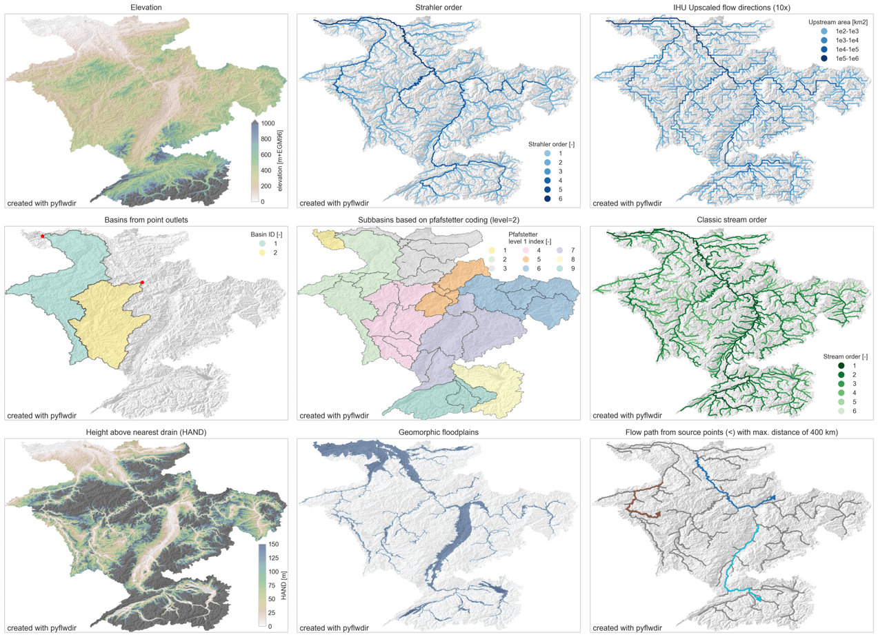
PyFlwDir contains a series of methods to work with gridded DEM and flow direction datasets, which are key to many workflows in many earth sciences. PyFlwDir supports several flow direction data conventions and can easily be extended to include more. The package contains some unique methods such as Iterative Hydrography Upscaling (IHU) method to upscale flow directions from high resolution data to coarser model resolution.
PyFlwDir is in pure python and powered by numba to keep it fast.
Featured methods
flow directions from elevation data using a steepest gradient algorithm
strahler stream order
flow direction upscaling
(sub)basin delineation
pfafstetter subbasins delineation
classic stream order
height above nearest drainage (HAND)
geomorphic floodplain delineation
up- and downstream tracing and arithmetics
hydrologically adjusting elevation
upstream accumulation
vectorizing streams
many more!
Installation
Quickstart
See user guide
Reference API
See reference API
Development and Testing
Welcome to the PyFlwDir project. All contributions, bug reports, bug fixes, documentation improvements, enhancements, and ideas are welcome. See Contributing to PyFlwDir for how we work.
Release history Release notifications | RSS feed


Download files
Download the file for your platform. If you're not sure which to choose, learn more about installing packages.
Source Distribution
Built Distribution
Filter files by name, interpreter, ABI, and platform.
If you're not sure about the file name format, learn more about wheel file names.
Copy a direct link to the current filters
File details
Details for the file pyflwdir-0.5.12.tar.gz.
File metadata
- Download URL: pyflwdir-0.5.12.tar.gz
- Upload date:
- Size: 1.2 MB
- Tags: Source
- Uploaded using Trusted Publishing? No
- Uploaded via: twine/6.1.0 CPython/3.13.13
File hashes
| Algorithm | Hash digest | |
|---|---|---|
| SHA256 |
b7ac69ee90f09626a827a3db3648bf28781400171ec8ed432c46020cf048c32a
|
|
| MD5 |
3b595fbd5394e377b13ef5fc9ee90d58
|
|
| BLAKE2b-256 |
8a4f745448e062d51fda4f2879ef18a16b1ad7afffc3bab2a5d66dc803353f52
|
File details
Details for the file pyflwdir-0.5.12-py3-none-any.whl.
File metadata
- Download URL: pyflwdir-0.5.12-py3-none-any.whl
- Upload date:
- Size: 66.5 kB
- Tags: Python 3
- Uploaded using Trusted Publishing? No
- Uploaded via: twine/6.1.0 CPython/3.13.13
File hashes
| Algorithm | Hash digest | |
|---|---|---|
| SHA256 |
0e1b292fb6671b32d502f0c1425b5205b4bce73aee9c0f49c8b664accd615438
|
|
| MD5 |
7eded8a33085e8ecf7b87149f6d402b8
|
|
| BLAKE2b-256 |
ad8b0382a28d88e48b4788bca131c86de9447e6bd34f9bc14e1884917a18786e
|


