

rasterstats is a Python module for summarizing geospatial raster datasets based on vector geometries. It includes functions for zonal statistics and interpolated point queries. The command-line interface allows for easy interoperability with other GeoJSON tools.
Documentation
For details on installation and usage, visit the documentation at http://pythonhosted.org/rasterstats.
What does it do?
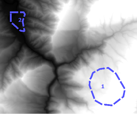
Given a vector layer and a raster band, calculate the summary statistics of each vector geometry. For example, with a polygon vector layer and a digital elevation model (DEM) raster, compute the mean elevation of each polygon.
Command Line Quick Start
The command line interfaces to zonalstats and point_query are rio subcommands which read and write geojson features
$ fio cat polygon.shp | rio zonalstats -r elevation.tif

$ fio cat points.shp | rio pointquery -r elevation.tif
See the CLI Docs. for more detail.
Python Quick Start
For zonal statistics
>>> from rasterstats import zonal_stats
>>> stats = zonal_stats("tests/data/polygons.shp", "tests/data/slope.tif")
>>> stats[0].keys()
dict_keys(['min', 'max', 'mean', 'count'])
>>> [f['mean'] for f in stats]
[14.660084635416666, 56.60576171875]
and for point queries
>>> from rasterstats import point_query
>>> point = {'type': 'Point', 'coordinates': (245309.0, 1000064.0)}
>>> point_query(point, "tests/data/slope.tif")
[74.09817594635244]
Issues
Find a bug? Report it via github issues by providing
a link to download the smallest possible raster and vector dataset necessary to reproduce the error
python code or command to reproduce the error
information on your environment: versions of python, gdal and numpy and system memory
1 maintainer

Metadata
1 maintainer
Release files for rasterstats 0.21.0
For a detailed explanation of source distributions (sdists) and built distributions (wheels), please see the package formats documentation.
Source distribution (sdist)
| File | Size | Uploaded | Provenance | |
|---|---|---|---|---|
| rasterstats-0.21.0.tar.gz | 76.8 kB | Without provenance | Details |
Built distribution (wheel)
| File | Interpreter | ABI | Platform | Reset |
|---|---|---|---|---|
| rasterstats-0.21.0-py3-none-any.whl | Python 3 | none | any | Details |
Total release size: 96.0 kB
Release files / rasterstats-0.21.0.tar.gz
| Download URL | rasterstats-0.21.0.tar.gz |
|---|---|
| Size | 76.8 kB |
| Tags | Source |
|
SHA-256 checksum How to use checksums |
2b955f6775b7f641c8094d00bc4381492184ba162b5dba1baa69df8db98efa5f
|
|
BLAKE2b-256 checksum How to use checksums |
3e5d52d2c6985c6ff3cefdd31876bd3e6e8ac09a5fc6d52703ed4dfa3b228062
|
| Upload date | |
|
Uploaded using Trusted Publishing? What is trusted publishing? |
No |
| Uploaded via |
twine/6.2.0 CPython/3.14.5
|
Release files / rasterstats-0.21.0-py3-none-any.whl
| Download URL | rasterstats-0.21.0-py3-none-any.whl |
|---|---|
| Size | 19.1 kB |
| Tags | Python 3 |
|
SHA-256 checksum How to use checksums |
6157d8bd1cc2fe3b3714abfa53b6a18c299efa7f70e8d9af71d3ef0408ac5c5d
|
|
BLAKE2b-256 checksum How to use checksums |
052e7c85f00260aa332fbab9caba209290a07be645ee1d5691415ae635a7382a
|
| Upload date | |
|
Uploaded using Trusted Publishing? What is trusted publishing? |
No |
| Uploaded via |
twine/6.2.0 CPython/3.14.5
|
Security for rasterstats 0.21.0
Provenance
Provenance describes where a file came from. On PyPI, provenance is shared via attestations, which provide a verifiable record of the build or publishing details. View details, limitations and caveats.
No provenance found
None of the files in this release were uploaded with provenance metadata.
A note on package security
PyPI is a repository for distributing packages, not a service for auditing them. While third-party security researchers and our staff do their best to detect and remove malicious packages, PyPI cannot guarantee the quality, security or suitability of any given package.
To learn more about protecting yourself from malicious actors, visit our package security documentation.














