
Welcome to Geoformat
Introduction
Geoformat is geopsatial library. The library aim is to simplify loading data and manipulations. Until now this library is in Alpha mode. This means that for the moment the structure of this library is not full oriented object compatible.
Installation
$ pip install geoformat
Geolayer structure
Geolayer is the equivalent of an attribute table. It stores entities that (see below) contain attribute data and/or geographic information.
For the moment a geolayer is a python dictionary. Some developments are underway to make it a python object easier to manipulate.
How is organised a geolayer
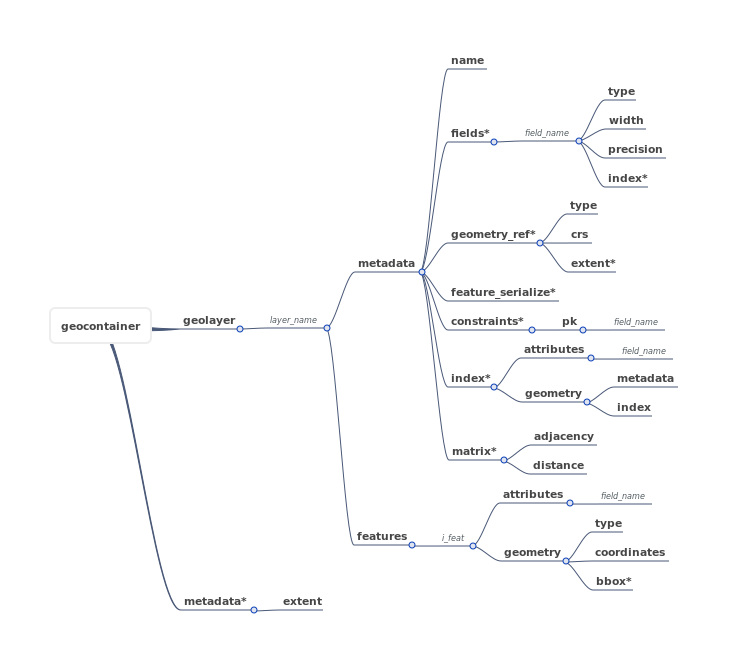
Geolayer metadata
'metadata' key in geolayer root structure is used to inform the structure of the geolayer.
If geolayer contains attribute data "fields" key must be filled in. If geolayer contains geometries data "geometry_ref" key must be filled in.
Field type
Each field in geolayer must be filed in "metadata" => "fields" structure.
Is informed : - field name - field type (mandatory) - field width (if necessary) - field precision (if necessary) - field index (optional)
    | type          | width    | precision | index    |
    +===============+==========+===========+==========+
    | 'Integer'     | None     | None      | Optional |
    | 'IntegerList' | None     | None      | Optional |
    | 'Real'        | Required | Required  | Optional |
    | 'RealList'    | Required | Required  | Optional |
    | 'String'      | Required | None      | Optional |
    | 'StringList'  | Required | None      | Optional |
    | 'Binary'      | None     | None      | Optional |
    | 'Date'        | None     | None      | Optional |
    | 'Time'        | None     | None      | Optional |
    | 'DateTime'    | None     | None      | Optional |
    | 'Boolean'     | None     | None      | Optional |
Geometry type
Each geometrie in geolayer must be filed in "metadata" => "geometry_ref" structure.
Is informed - type : each geometries type code present in geolayer (see table below) - crs : coordinate reference systeme in WKT format or EPSG
List of valid geometries :
| Code | Name |
|---|---|
| 0 | Unknown |
| 1 | Point |
| 2 | LineString |
| 3 | Polygon |
| 4 | MultiPoint |
| 5 | MultiLinestring |
| 6 | MultiPolygon |
| 7 | GeometryCollection |
| 100 | None |
Feature structure
The feature is de basic object that contains information. This information is of two types:
- attributes : alphanumeric data that describes feature
- geometry : type and coordinates that describe geometrically the feature
attributes
geometry
There are seven types of geometries that we can group into 3 categories.
basics
| type | representation | sample data | geoformat |
|---|---|---|---|
| Point |  |
underground station | { |
| LineString |  |
a road | { |
| Polygon |  |
an island | { |
composed
| type | representation | sample data | geoformat |
|---|---|---|---|
| MultiPoint |  |
exits from same underground station | { |
| MultiLineString |  |
a river with several tributaries | { |
| MultiPolygon |  |
a country with an island | { |
sets
| type | representation | sample data | geoformat |
|---|---|---|---|
| GeometryCollection |  |
a mix of all examples above | { |
Drivers
Driver are usefull for reading and writing data in a geospatial standard like Esri Shapefile, Geojson, Postgres/Postig, csv ...
Geoformat is progressively integrating its own drivers but it is possible to use the GDAL/OGR library drivers.
Geoformat driver
| driver | read | write | read function name | write function name |
|---|---|---|---|---|
| Geojson | X | X | geojson_to_geolayer | geolayer_to_geojson |
| Postgres / Postgis | NOK | X | geolayer_to_postgres | |
| CSV | X | X | csv_to_geolayer | geolayer_to_csv |
| esri shapefile | X | X | shapefile_to_geolayer | geolayer_to_shapefile |
OGR GDAL driver
Usefull if you want to work with ESRI SHAPEFILE or MAP INFO FILE or GML you can use this two functions :
| read | write |
|---|---|
| ogr_layer_to_geolayer | geolayer_to_ogr_layer |
list of maintained drivers :
| driver_name |
|---|
| "ESRI SHAPEFILE" |
| "MAPINFO FILE" |
| "POSTGRESQL" |
| "GML" |
| "KML" |
| "XLSX" |
| "CSV" |
| "GEOJSON" |
Examples
Open a geocontainer
A container is an equivalent to folder or a database containing one or several geolayer.
import geoformat

commune_path = 'data/FRANCE_IGN/COMMUNE_2016_MPO_L93.shp'
gare_path = 'data/FRANCE_IGN/GARES_PT_L93.shp'

layer_list = [commune_path, gare_path]

geocontainer = geoformat.ogr_layers_to_geocontainer(layer_list)

print(geocontainer['layers'].keys())

# >>>dict_keys(['COMMUNE_2016_MPO_L93', 'GARES_PT_L93'])
Open a geolayer
A geolayer is an equivalent to a file or a table in database containing one or several features with attibutes and/or geometry.
import geoformat

departement_path = 'data/FRANCE_IGN/DEPARTEMENT_2016_L93.shp'

geolayer = geoformat.shapefile_to_geolayer(departement_path)

print(len(geolayer['features']))

# >>>96
Print data geolayer
Sometime it can be uselful to print in terminal geolayer's attributes.
import geoformat

region_path = 'data/FRANCE_IGN/REGION_2016_L93.shp'

geolayer = geoformat.shapefile_to_geolayer(region_path)

print(geoformat.print_features_data_table(geolayer))


### >>>
+--------+----------+-------------------------------------+------------+------------+
| i_feat | CODE_REG | NOM_REG                             | POPULATION | SUPERFICIE |
+========+==========+=====================================+============+============+
| 0      | 76       | LANGUEDOC-ROUSSILLON-MIDI-PYRENEES  | 5683878    | 7243041    |
| 1      | 75       | AQUITAINE-LIMOUSIN-POITOU-CHARENTES | 5844177    | 8466821    |
| 2      | 84       | AUVERGNE-RHONE-ALPES                | 7757595    | 7014795    |
| 3      | 32       | NORD-PAS-DE-CALAIS-PICARDIE         | 5987883    | 3187435    |
| 4      | 44       | ALSACE-CHAMPAGNE-ARDENNE-LORRAINE   | 5552388    | 5732928    |
| 5      | 93       | PROVENCE-ALPES-COTE D'AZUR          | 4953675    | 3155736    |
| 6      | 27       | BOURGOGNE-FRANCHE-COMTE             | 2819783    | 4746283    |
| 7      | 52       | PAYS DE LA LOIRE                    | 3660852    | 2997777    |
| 8      | 28       | NORMANDIE                           | 3328364    | 2728511    |
| 9      | 11       | ILE-DE-FRANCE                       | 11959807   | 1205191    |
| 10     | 24       | CENTRE-VAL DE LOIRE                 | 2570548    | 3905914    |
| 11     | 53       | BRETAGNE                            | 3258707    | 2702269    |
| 12     | 94       | CORSE                               | 320208     | 875982     |
+--------+----------+-------------------------------------+------------+------------+
Change geolayer coordinate reference system [CRS]
It can be usefull to change the projection for a layer. In this example we will transform a geolayer in projection Lambert93 [EPSG:2154] to coordinates system WGS84 [EPSG:4326].
import geoformat

region_path = 'data/FRANCE_IGN/REGION_2016_L93.shp'

geolayer = geoformat.shapefile_to_geolayer(region_path)

geolayer = geoformat.reproject_geolayer(geolayer, in_crs=2154, out_crs=4326)

print(geolayer['metadata']['geometry_ref']['crs'])

# >>>4326
Write geolayer in a OGR compatible GIS file
You can obviously convert a geolayer in a compatible OGR file format. In this case ye put a geolayer in 'ESRi SHAPEFILE' format and we create a new file in 'GEOJSON' (we add a reprojection because geojson should be in WGS84 coordinates system).
import geoformat

gares_shp_path = 'data/FRANCE_IGN/GARES_L93.shp'
gares_geojson_path =  'data/FRANCE_IGN/GARES_L93.geojson'

geolayer = geoformat.shapefile_to_geolayer(gares_shp_path, encoding='iso-8859-15')

geolayer = geoformat.reproject_geolayer(geolayer, in_crs=2154, out_crs=4326)

geoformat.geolayer_to_geojson(geolayer, gares_geojson_path, overwrite=True)

geojson_geolayer = geoformat.geojson_to_geolayer(path=gares_geojson_path)

# print 10 first features of geojson geolayer
print(geoformat.print_features_data_table(geojson_geolayer, limit=10))

>>>
+--------+------------+---------------+------+-----------+------------+------+---------+------------+------------+-----------+-----------+------------------+-----------------+-------+--------------------------------+
| i_feat | code_uic   | libelle_ga    | fret | voyageurs | code_ligne | rang | pk      | x_lambert_ | y_lambert_ | x_wgs84   | y_wgs84   | commune          | departemen      | type  | coordinates                    |
+========+============+===============+======+===========+============+======+=========+============+============+===========+===========+==================+=================+=======+================================+
| 0      | 87471185.0 | Messac-Guipry | N    | O         | 463000     | 1.0  | 398+272 | 339653.0   | 6757878.0  | -202440.0 | 6077344.0 | Messac           | Ille-et-Vilaine | Point | [-1.8185528943432585, 47. ...] |
| 1      | 87471029.0 | Vern          | N    | O         | 466000     | 1.0  | 50+491  | 357685.0   | 6781809.0  | -177731.0 | 6114673.0 | Vern-sur-Seiche  | Ille-et-Vilaine | Point | [-1.5965909351293788, 48. ...] |
| 2      | 87476317.0 | Quimperlé     | O    | O         | 470000     | 1.0  | 639+694 | 210637.0   | 6772419.0  | -395516.0 | 6085140.0 | Quimperlé        | Finistère       | Point | [-3.552988951324049, 47.8 ...] |
| 3      | 87474031.0 | Hanvec        | N    | N         | 470000     | 1.0  | 740+360 | 171994.0   | 6828441.0  | -460348.0 | 6163846.0 | Hanvec           | Finistère       | Point | [-4.135378530070003, 48.3 ...] |
| 4      | 87476671.0 | Questembert   | O    | O         | 470000     | 1.0  | 540+326 | 291464.0   | 6745525.0  | -272690.0 | 6054309.0 | Questembert      | Morbihan        | Point | [-2.4496209535332447, 47. ...] |
| 5      | 87476648.0 | Ste-Anne      | N    | O         | 470000     | 1.0  | 581+996 | 253190.0   | 6747773.0  | -329570.0 | 6053535.0 | Pluneret         | Morbihan        | Point | [-2.960580973370048, 47.6 ...] |
| 6      | 87471243.0 | St-Méen       | O    | N         | 472000     | 1.0  | 68+200  | 315077.0   | 6800114.0  | -243043.0 | 6138128.0 | St-Méen-le-Grand | Ille-et-Vilaine | Point | [-2.1832958937261893, 48. ...] |
| 7      | 87476200.0 | Auray         | O    | O         | 473000     | 1.0  | 584+946 | 250286.0   | 6748188.0  | -333913.0 | 6053823.0 | Auray            | Morbihan        | Point | [-2.99959548260269, 47.68 ...] |
| 8      | 87476408.0 | Belz-Ploemel  | N    | O         | 473000     | 1.0  | 591+597 | 244616.0   | 6745536.0  | -341998.0 | 6049244.0 | Ploemel          | Morbihan        | Point | [-3.072226071667076, 47.6 ...] |
| 9      | 87473330.0 | Quintin       | O    | O         | 475000     | 1.0  | 492+810 | 264298.0   | 6827046.0  | -321902.0 | 6173216.0 | St-Brandan       | Côte-d'Armor    | Point | [-2.8917008446444417, 48. ...] |
+--------+------------+---------------+------+-----------+------------+------+---------+------------+------------+-----------+-----------+------------------+-----------------+-------+--------------------------------+


Download files
Download the file for your platform. If you're not sure which to choose, learn more about installing packages.
Source Distribution
File details
Details for the file geoformat-20240113.tar.gz.
File metadata
- Download URL: geoformat-20240113.tar.gz
- Upload date:
- Size: 2.1 MB
- Tags: Source
- Uploaded using Trusted Publishing? No
- Uploaded via:
twine/3.1.1 pkginfo/1.4.2 requests/2.22.0 setuptools/45.2.0 requests-toolbelt/0.8.0 tqdm/4.66.1 CPython/3.8.10
File hashes
| Algorithm | Hash digest | |
|---|---|---|
| SHA256 |
1ba9eb9330c31647d794a4c6123a19d46dfe14575778ea916941cf1345606413
|
|
| MD5 |
f7914d7fee42c6e41739a41f8e9abf86
|
|
| BLAKE2b-256 |
e4d896c44848b136fd14a039640b695e87250ed402914d04534dd00fe91954b0
|














